Datchet to Hythe End flood improvement measures
Updated 3 June 2025
Applies to England

© Crown copyright 2025
This publication is licensed under the terms of the Open Government Licence v3.0 except where otherwise stated. To view this licence, visit nationalarchives.gov.uk/doc/open-government-licence/version/3 or write to the Information Policy Team, The National Archives, Kew, London TW9 4DU, or email: psi@nationalarchives.gov.uk.
Where we have identified any third party copyright information you will need to obtain permission from the copyright holders concerned.
This publication is available at https://www.gov.uk/government/publications/datchet-to-hythe-end-flood-improvement-measures/datchet-to-hythe-end-flood-improvement-measures
Get the latest project updates on the Datchet to Hythe End flood improvement measures engagement HQ page.
1. Background
Many of the communities in this area have been affected by several major floods. The most notable was in 1947. More recently floods affected homes and businesses in 2003 and again in 2013/14. This followed prolonged and widespread flooding from the River Thames.
River Thames is not the only source of flooding in the area. Other sources that could cause flooding are:
- surface water
- groundwater
- other watercourses
- infrastructure
We are working in partnership with the Royal Borough of Windsor and Maidenhead to find solutions that work for communities and their environment. It is not possible to protect against every eventuality. But we are determined to reduce the risk of flooding and help secure the necessary funding.
We have previously carried out work to refurbish the Battle Bourne embankment flood defence in Old Windsor.

Aerial view showing flooding south of Wraysbury in February 2014.
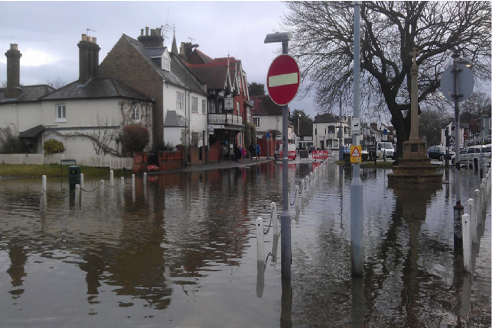
Floodwaters in Datchet village during February 2014. Image shows a flooded street scene with houses to the left and a tree, memorial and sign posts to the right.
2. Plans to better protect the area from flooding
The River Thames between Datchet and Teddington is one of the largest areas of undefended, developed floodplain in England. The area suffered serious floods in the past. Climate change means the risk of flooding is only going to grow. A long-term, sustainable plan is needed to deal with this risk.
The River Thames Scheme was planned to carry out the recommendations set out in the Lower Thames Flood Risk Management Strategy. This was finalised in 2009 after consultation with:
- other public bodies
- businesses
- residents
The Strategy was approved by the Environment Agency Board in 2010 and accepted by the Department for Environment, Food and Rural Affairs (Defra) in 2011.
The River Thames Scheme comprises a new river channel built in 2 sections at Runnymede and Spelthorne.
It also includes improvements to:
- existing river structures
- new recreation areas for communities
- new habitat for wildlife
These measures will:
- better protect thousands of homes and businesses
- enhance the natural environment around the river
- boost the local economy
The River Thames from Datchet to Hythe End was previously included in the River Thames Scheme as Channel 1. However, this work was not possible without more funding or greater flexibility over council tax.
This meant that River Thames Scheme Sponsorship Group decided in July 2020 to proceed without Channel 1. The council’s original commitment of £10 million is still available for alternative flood alleviation works.
3. Datchet to Hythe End flood improvement measures
As a result, we have established the Datchet to Hythe End flood improvement measures project. The project aims to better protect the communities that would previously have been at reduced risk of flooding due to the presence of Channel 1. This includes approximately 2,500 properties.
Find out more about the project on the Datchet to Hythe End flood improvement measures engagement HQ page.
4. Funding
The main source of money for flood schemes are flood and coastal erosion risk management grant-in-aid projects provided by central government through Defra. This funding is governed by the government’s Partnership Funding policy introduced in 2011. It uses the estimated benefits and costs of a project to calculate how much government funding a scheme is eligible for.
The remaining funding, known as Partnership Funding, is then sought from other potential partners. These may include:
- the local council
- regional flood and coastal committees
- utilities and infrastructure companies
- other organisations and businesses that benefit from the scheme
This is the standard way in which flood schemes are funded today.
5. Find out if you are at risk of flooding
Sign up for flood alerts and warnings to stay aware of the risk of flooding in your area. Visit the Flooding and extreme weather page or call Floodline on 0345 988 1188 for more information.
You can also visit the Met Office website for local weather forecasts.
6. Prepare for flooding
Find information about steps you can take to prepare for flooding.
7. Contact
For further information, or to provide feedback please contact:
THM.Schemes@environment-agency.gov.uk
Or call the Environment Agency customer contact centre on 03708 506 506 or Royal Borough of Windsor and Maidenhead on 01628 683 800.
If you are concerned about a pollution incident, or a blockage in the river, please call the Environment Agency’s 24-hour hotline on 0800 80 70 60.