Mine entries data set: User guide
Updated 9 February 2024

© Crown copyright 2024
This publication is licensed under the terms of the Open Government Licence v3.0 except where otherwise stated. To view this licence, visit nationalarchives.gov.uk/doc/open-government-licence/version/3 or write to the Information Policy Team, The National Archives, Kew, London TW9 4DU, or email: psi@nationalarchives.gov.uk.
Where we have identified any third party copyright information you will need to obtain permission from the copyright holders concerned.
This publication is available at https://www.gov.uk/government/publications/coal-mining-data-mine-entries/mine-entries-dataset-user-guide
1. Introduction
The Coal Authority manages the effects of past coal mining, including subsidence damage claims which are not the responsibility of licensed coal mine operators. It deals with mine water pollution and other mining legacy issues. It also owns, on behalf of the country, the majority of the coal in Britain and licenses coal mining.
We use our skills to provide services to other government departments and agencies, local governments and commercial partners. We contribute to the delivery of the UK government’s Industrial Strategy and the environmental, social and economic priorities of the UK, Scottish and Welsh governments.
By sharing our knowledge and expertise we support them, and our partners, to create cleaner, greener nations for us all.
Our purpose is to:
- keep people safe and provide peace of mind
- protect and enhance the environment
- use our information and expertise to help people make informed decisions
- create value and minimise cost to the taxpayer
The Coal Authority is an executive non-departmental public body, sponsored by the Department for Energy Security and Net Zero.
Further information on all the digital data available from the Coal Authority
2. Information about the mine entries data set
The Coal Mines Regulation Act (1872) and Metalliferous Mines Regulation Act (1872) require coal mine operators to deposit mine abandonment plans with the Secretary of State following the end of operations. Before this mine plans were often destroyed or kept in private ownership due to competition between the mine operators.
The Coal Authority’s Mining Heritage Centre in Mansfield, Nottinghamshire, houses around 120,000 coal abandonment plans, covering both opencast and deep mining operations, which show areas of coal extraction and the points of entry into workings.
These plans are held by the Coal Authority on behalf of the Health and Safety Executive. The mining information contained on these plans has been captured in the Coal Authority’s national coal mining database.
The national coal mining database has records of more than 172,000 mine entries within the UK, derived from sources including abandonment, geological and topographical plans.
Coal mining is recorded as far back as the 13th century, but before 1872 there was no requirement to deposit abandonment plans, so there may be many unrecorded mine entries of which the Coal Authority has no information or knowledge. These entries do not, therefore, appear within the national data set as described here.
2.1 Data set history
The mine entries spatial data set was created during the early 1980s in readiness for the automated provision of coal mining reports that was introduced locally in 1985 and established nationally in 1989.
A team of qualified National Coal Board and British Coal Corporation mining surveyors were engaged to rationalise the mining and other source plans, reference them to Ordnance Survey National Grid or County Series and subsequently capture the data into the first computerised mining report system.
The spatial data sets were subsequently migrated into the Coal Authority’s current ESRI-based GIS in 2011.
2.2 Who might require this data set?
This data set is used by the Coal Authority in the production of CON29M mining search reports. These provide property specific searches with regard to potential mining hazards in support of the conveyancing market.
This data set is suitable for use by organisations wishing to identify possible ground instability and potential mining hazards. Users may include but are not limited to local authorities, infrastructure operators, land developers, home-owners, solicitors, loss adjusters, the insurance industry, architects and surveyors.
2.3 What the data set shows
The layer shows the best-plot position for each mine entry from the information held by the Coal Authority and includes a number of attributes.
For around 70% of the recorded mine entries within the data set the Coal Authority holds no treatment details. This is largely because the Coal Authority’s records go back only as far as the nationalisation of the coal industry (1 January 1947). Before this the treatment of any mine entry was a matter between the mineral owner and the mineral worker.
2.4 Coverage
The coverage of the mine entries data set is the known extent of coal mining activity in Great Britain. This area does not represent the full extent of geological coal reserves and resources.
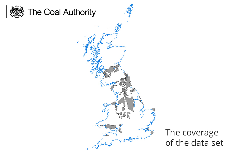
A map showing Great Britain and the coverage of the data set.
3. Technical information
3.1 Definitions - mine entries
Mine entries are entrances into mine workings of which there are two main types, shafts and adits.
Mine shafts are vertical or near vertical entrances, whereas adits are horizontal or near-horizontal (walkable) entrances.
Mine entrances provide points of access, ventilation, drainage and mineral extraction.
3.2 Accuracy - departure
The location of a mine entry fixed by field survey is often different to the position of the same entry shown on the source plan, this difference being termed the ‘departure’.
Experience has shown that the positions shown on certain source plans carry more reliance than others and therefore the departure attributed by the Coal Authority is dependent on the original source as follows.
| Source plan | Departure |
|---|---|
| Definitive position from field survey | 0m departure |
| 1:2,500 Ordnance Survey plan | 5m departure |
| Abandonment plan | 8m departure |
| All other plans and specific instances | 10m departure |
Transfer of information from source plans to the National Coal Mining Database
The position of the mine entries as depicted within the data set is to an extent dependent on the accuracy and diligence of the surveying and recording undertaken at the time of abandonment.
The mining information contained on the rationalised plans was digitised by a team of technicians and captured as polygon, point and line data in the Coal Authority’s National Coal Mining Database.
Most of the abandonment plans were drawn at scales no longer in use, and there is commonly limited control information in relation to current topographical data against which to accurately locate mine entries.
The captured mine entry positions in this digital data set are therefore ‘best fix’ positions based on the source abandonment plans and modern topographical data.
Source accuracy limitations
All plans are representations and may contain inherent simplifications due to generalisation. When features are represented on plans, their scale often determines the level of detail shown. In addition to these simplifications, limitations may also be introduced through the drawing process.
Digitisation process accuracy limitations
The digitisation process is likely to have introduced intrinsic limitations due to simplification requirements.
As different mining surveyors produced plans with variable levels of detail, the Coal Authority’s mining surveyors may have reduced the level of detail contained within the plans in order to produce the digital information.
Scale
The original plans were produced at varying scales, but were in general digitised to a scale of 1:2,500.
Ordnance Survey positional accuracy
Approximately 60% of the Coal Authority’s mine entry locations were moved following the Ordnance Survey positional accuracy improvement programme (PAI).
Expert Coal Authority staff reviewed each mine entry and source records to assess if they needed to be moved in relation to PAI.
Where a mine entry was originally located by surveying surface features and those surface features were within a PAI area, then the mine entry was flagged as needing to be repositioned accordingly.
The repositioning work was an automated ‘rubber sheet’ process, implemented using PAI link files supplied by Ordnance Survey and was subject to quality control procedures carried out by expert Authority mining surveyors.
More information on PAI can be accessed on the Ordnance Survey website: http://www.ordnancesurvey.co.uk/business-and-government/help-and-support/navigation-technology/pai.html
3.3 Data format
The mine entries data set has been created as vector polygon data and is available in ESRI File Geodatabase (.gdb) format. Other geospatial formats, including geopackages and computer-aided design, can be supplied on request but may incur additional processing costs.
The layer file provided will describe the symbology used by the Coal Authority and has been created using ESRI ArcGIS V10.3.1
Use of any other symbology is not advised for this data set as the symbology used by the Coal Authority is an industry standard and any change of this could significantly affect the perceived understanding.
In order to view the correct symbology, the layer file should be loaded in your GIS system.
3.4 Field descriptions
|
Data Field |
Explanation of Data Field |
|---|---|
|
OBJECTID |
OBJECTID File GeoDB ID number |
|
S_ OBJECTID[footnote 1] |
Source Object ID Unique Coal Authority ID number |
|
ASUM_DMT |
ASSUMED SHAFT DIAMETER Where information about the diameter of a shaft is not known it will be assumed. The assumption will be based upon comparison with other shafts in the vicinity, the likely date it was sunk and any other relevant information. |
|
MI_CODE |
MINERAL Mineral worked. Most are coal but we hold records for other minerals on the system in cases where they were worked with the coal or close to the coal seams. |
|
SOLD_IND |
CONVEYED Conveyed Indicator: True or False. True equals the mine entry has been conveyed. |
|
ADT_ANGL |
ADIT ANGLE Adit Direction – If the mine entry is an adit, then this is the recorded direction, in degrees from North, of the entrance roadway. If the mine entry is a shaft then no direction is recorded and this field is populated by default with a ‘0’. |
|
DPARTURE |
DEPARTURE An assumed distance representing the potential difference between a mine entry’s plotted position and its true position. This assumed distance will be between 0 to 10 metres and will depend, inter alia on age, scale, condition and status of the source plan from which the position is taken. |
|
OWNER[footnote 1] |
OWNER Owner of the mine entry. |
|
RFRNC |
REFERENCE The reference number of the mine entry derived from the km square location. |
|
TRMT_IN |
TREATED Treated Indicator: True or False. True denotes we hold record of treatment details on our database. False denotes we hold no record of treatment details on our database. Treatment details are generally only known post coal industry nationalisation in 1947. |
|
SHFT_DMT |
ACTUAL SHAFT DIAMETER Diameter of mine entry in metres. Where a shaft is not circular the maximum diagonal dimension will be used. |
|
DEPTH |
SHAFT DEPTH Depth of mine entry in metres from surface. The Coal Authority will only provide the depth of a mine entry where this is known. |
|
SOLD_DT |
DATE OF CONVEYANCE The date the mine entry was conveyed. |
|
TRTMT_DT |
DATE OF TREATMENT Date the mine entry was treated, if known. |
|
SOURCE[footnote 1] |
MINE ENTRY SOURCE Source documents for mine entry. There may be several source documents for the same mining information and in many instances these documents are very old. As a general rule older sources are not as accurate as more recent records. |
|
TRTMT_DS[footnote 1] |
TREATMENT DESCRIPTION This is where a description of treatment, if any, carried out to the mine entry is recorded on our database. |
|
TYPE |
MINE ENTRY TYPE Denotes if mine entry is a shaft or an adit. Shaft being a vertical or near vertical entrance to an underground mine. Adit is an entrance to an underground mine which is horizontal or nearly horizontal. |
|
DRIFT_DP |
DRIFT THICKNESS Depth in metres of surface deposits at mine entry xy, where known. |
|
NAME |
MINE ENTRY NAME Local name of mine entry. |
|
OPENCAST_ FLAG |
WITHIN OPENCAST AREA Opencast Flag: True or False. True denotes we believe this mine entry to have been removed by subsequent surface mining activities. |
|
COLLIERY_NAME |
COLLIERY Name of colliery this mine entry is associated with. This attribute is rarely populated. |
|
GLOBALID |
GlobalID A Universal Unique Identifier automatically assigned by the geodatabase. |
|
VERIFIED |
Verified Verified indicator: True or False. An attribute that determines whether manual intervention is required. Where verified indicator equals False then further information should be sought from the Coal Authority when used in the context of a mining search report, for example CON29M |
3.5 Data update frequency
The Coal Authority is constantly reviewing and updating its data. We therefore make no representation that the mine entries data set remains complete, accurate, up-to-date, reliable or exhaustive. Weekly, annual or one-off updates will be provided as per the licence arrangement.
4. Licensing information
The Coal Authority does not sell its digital spatial data to external parties. Instead, it grants external parties a licence to use the data, subject to terms and conditions. In general, a licence fee will be payable based on the type of data, geographic area required, the number of simultaneous users, and the duration (years) of a licence.
All recipients of a licence are required to return a signed licence document to us before authorisation for release of digital data is given.
These are general comments for guidance only. Full details of the terms and conditions of supply are included within licences.
The Coal Authority’s data team will be happy to discuss your proposed use of data and can be contacted at datasolutions@coal.gov.uk .
The data team will usually be able to provide reassurance that the licence will cover individual user requirements or include additional ‘special conditions’ in the licence documentation, addressing specific requirements within the Coal Authority’s permitted usage.
5. Limitations and exclusion of liability
The Coal Authority is committed to ensuring that the digital data it holds and releases to external parties under licence has been through a robust internal approval process to ensure that corporate quality assurance standards are maintained.
This approval process is intended to ensure that all data released is :
- is quality assured
- meets agreed data management standards
- is not in breach of any 3rd party intellectual property rights, or other contractual issues - such as confidentiality issues
5.1 Limitations
This data set is based on, and limited to, an interpretation of the records in the possession of the Coal Authority at the time the data set was created.
The data set does not categorise the risk of surface collapse and no account is taken of any past remediation that may have been undertaken.
An indication of presence of a coal mining related feature, such as a mine entry, does not necessarily mean that a location will be affected by ground movement or subsidence. Such an assessment can only be made by inspection of the area by a qualified professional.
If customers are uncertain about the use of particular data they should seek professional advice. However, they may consult the Coal Authority’s data team on technical matters, licensing arrangements, or general aspects including the appropriateness and limitations of the data.
5.2 Exclusions
The databases comprising the subject matter of this report are made up of information supplied to the Coal Authority by third parties under statutory obligation and of which the Coal Authority has no direct knowledge and has not necessarily had the opportunity to verify. Accordingly, it can have no liability for the accuracy of the information comprising the databases or for any loss of whatever nature directly or indirectly caused which may result from any reliance placed upon it.
The licensee takes the information as provided without any such express or implied warranty and must rely upon its own enquiries and where necessary obtain appropriate insurance against any loss arising.