UKHO supports UK emergency services by unlocking access to marine data sets
Rich geospatial data is now accessible via ResilienceDirect to support emergency responders and planners across the UK
The UK Hydrographic Office (UKHO) has launched a range of services providing UK emergency responders and planners with access to an extensive suite of marine geospatial data through the UK government’s centralised ResilienceDirect network.
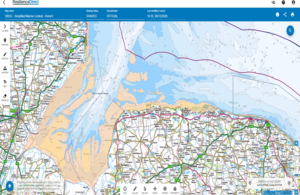
A range of seven different data sets have been added to ResilienceDirect over the last month. These data sets complement the existing Simplified Marine Context Service, which was developed by the UKHO in response to a need for marine context data within a range of government applications.
The addition of the Simplified Marine Context service to the Cabinet Office’s ResilienceDirect platform will give civil protection practitioners access to vital marine data in the preparation, response and recovery phases of an event or emergency. ResilienceDirect is a private secure web-based service for the UK and Overseas Territories which enables civil protection practitioners to work together across geographical and organisational boundaries.
The newly added data sets include extensive information on the UK Exclusive Economic Zone, Continental Shelf and Territorial Boundaries, UK port limits, current UK 6 and 12 nautical mile fishing limits and Marine Protected Areas. There is also vital information on essential offshore infrastructure and wreck data. As the service develops, additional layers will be added.
Luana Avagliano, Head of ResilienceDirect, commented:
I am thrilled to be working with the UK Hydrographic Office, ensuring that the UK ResilienceDirect service now has sanitised digital marine coverage to provide a full capability where the land ends. Their world-leading digital services will support our community and assist with our mission to save lives and aim to keep the UK safe.
Simon Hampshire, Product Manager, UKHO, said:
Emergency responders do nothing less than put their lives on the line to help us during times of crisis. Effective data is a crucial part of their efforts, giving them the insights needed to produce robust operational plans and ensure they have full knowledge of the geography of an incident. We are proud to support our colleagues across government and bring our extensive data to these responders via ResilienceDirect. With our Simplified Marine Context Service and range of marine geospatial services, we are helping responders and planners access the crucial data they need to operate effectively within the challenging marine environment.
According to the Coastguard Search and Rescue Coordination Network, in 2018 there were more than 24,000 incidents in UK waters. The addition of reliable marine data can significantly improve the process of emergency response, allowing for greater cross-government collaboration in responding to large incidents that involve the maritime environment.