Heavy rain increases flood-risk across South East
Don’t drive through floodwater – stay away from swollen rivers.
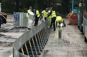
Picture shows workers in yellow jackets assembling metal barriers in a concreted area with buses parked to the right
The Environment Agency is warning communities that persistent heavy rain could lead to an increased risk of flooding across South East England over the next few days.
The forecast heavy rain could cause surface water flooding in local communities, and see a rise in river levels, and travel disruption as roads and rail lines may be affected.
At midday today, there were 82 flood alerts, which means flooding is possible, while it is expected in another 28 locations across the region. With further rainfall forecast, this figure is likely to go up.
Dave Bedlington, duty manager for the Environment Agency, said:
Heavy downpours across the South East have led to surface water flooding and significant travel disruption today, Friday 20 December, and may do so into the weekend. Due to the heavy rain, we have put up temporary flood barriers in Guildford, on Mary Road, through the bus depot and on to Leas Road, and Guildford Road Bridge in Leatherhead, protecting almost 70 properties in the two locations.
In response to recent rainfall and increasing river flows on the River Thames, the Environment Agency has operated the Maidenhead, Windsor and Eton Flood Alleviation Scheme, which includes the Jubilee River, which has been reducing the risk of flooding from the River Thames to approximately 3,000 properties in Maidenhead, Windsor and Eton since 2002.
We are assessing 3 rivers in the east of the region, the Mole, the Medway and the Stour, and will issue any local flood alerts or warnings locally as required.
Our teams have been out on the ground checking flood defences, clearing debris from rivers, and will continue to support our partners to reduce the impacts of the heavy rain. We will issue flood warnings and alerts where necessary.
We urge the public to prepare to take action when at risk of flooding, even if a temporary barrier is in place. There are a number of things you can do to prepare for flooding to keep yourself and your family safe. Find out if your home is at risk, sign-up for flood warnings and be ready to take action. For more information, visit GOV.UK or call Floodline on 0345 988 1188.
People should remain vigilant, check their flood-risk and plan to stay safe. We urge people to stay away from swollen rivers and not to walk or drive through flood water as just 30cm/12ins of flowing water is enough to move your car.
People on Twitter can follow updates on flood-risk on the Environment Agency’s South East and national accounts, @EnvAgencySE and @EnvAgency.
Notes to editors
Flood alerts indicate that people should be aware. Flood warnings mean that flooding is expected and people should take action to stay safe. A severe flood warning means that there is a risk to life – people should take immediate action and follow the advice of the emergency services.
What are temporary barriers and how do they work?
- Temporary flood barriers are portable metal frames with a water proof barrier that can be quickly deployed to help reduce the impact of flooding.
- When deployed, our barriers create a temporary wall to help reduce the impact of flooding to people properties and businesses.
- When there is no longer a risk of flooding the temporary barriers are completely removed. The barrier is checked and put back into storage ready to be used again.
- Temporary flood barriers can reduce the impact of flooding in communities which do not currently benefit from a permanent flood protection scheme.
- Although temporary flood barriers can reduce the impact of flooding when in place, we cannot guarantee that they will always be deployed and effective in every situation. We strongly advise that people continue to prepare and take action to reduce the impact of flooding to homes and businesses.
Jubilee River
- The Jubilee River, part of the Maidenhead, Windsor and Eton Flood Alleviation Scheme, was designed to alleviate flooding to those areas flooded in the Great Floods of 1947, when 2,000 homes were flooded.
- The river was designed to appear natural with the channel varying in shape, containing wetlands and islands. This wildlife corridor, known as Dorney Wetlands, is part of the 193 hectares of native woodland, 38 hectares of reed bed and 326 hectares of wildflower grassland.