Devon section of King Charles III England Coast Path complete
Some 78 miles on the south coast and 75 miles on the north coast is now open. Works have seen upgraded walkways, landscaping and habitat improvements
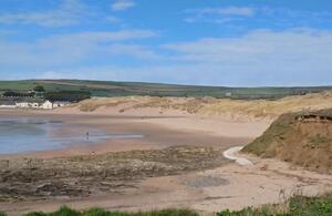
Croyde causeway restoration. Photo: Devon County Council
Two new sections of the King Charles III England Coast Path (KCIIIECP), together covering more than 150 miles along the north and south coasts of Devon, have been opened today (17 December).
These works form part of a national programme to create a coastal footpath around the whole of England and establish coastal access rights between the trail and mean low water. Once completed the KCIIIECP will be the longest managed coastal walking route in the world and the UK’s longest National Trail. In Devon, the paths adopt and in places improve the existing South West Coast Path.
On the north coast, the new section of KCIIIECP stretches from Combe Martin to Marsland Mouth on the Devon-Cornwall border, whilst on the south coast the new section is from Cremyll at the Tamar estuary, to Kingswear.
These two sections join other open sections around the south-west peninsula and create an amazing 600 miles of continuous open trail, with an accessible coastal margin to the water’s edge taking in typical coastal land types such as cliffs, dunes, beaches and foreshore, from Brean Down to Lyme Regis around the south-west peninsula. This not only also takes the total of open KCIIIECP nationally to over 2000 miles, but also significantly improves the existing South West Coast Path.
The north coast stretches from Combe Martin to Marsland Mouth
Route clearance for the new path at Downend Croyde. Photo: Devon County Council
The 75 miles north coast stretch is set against the backdrop of Lundy Island. It passes through the Taw Torridge estuaries, a haven for wildfowl, waders and gulls, the sand dunes of Braunton Burrows, home to over 470 species of plants and wildflowers and also a training beach for the D-Day landings in 1944 and the undulating Hartland Peninsular. Part of this stretch, between Hartland Point and Marsland Mouth, around 10 miles in length, is seen as one of the toughest sections to walk in the southwest. The route passes through the holiday centres of Ilfracombe, Woolacombe, Croyde, Saunton Sands, Appledore and Westward Ho!
Access to the saltmarsh in the coastal margin of the Taw-Torridge estuary is to be excluded all year-round as it is unsuitable for public access.
As the South West Coast Path, becomes part of the KCIIIECP improvement works have included restoring a concrete causeway across the southern part of Croyde beach and at Watertown in Appledore a new short section of off-road, traffic free path, above the high tide line, has improved connectivity between Appledore and Northam Burrows.
The south coast stretches from Cremyll at the Tamar estuary, to Kingswear

Mothecombe Beach. Photo: Devon County Council
The 78 miles south coast stretch runs along the clifftops between the historic ports of Plymouth and Dartmouth/Kingswear. The trail crosses seven estuaries, six by ferry and one that can only be crossed on foot at low tide. The route includes the iconic coastal bar of Slapton Sands from Torcross and Strete Gate which has its own historic links to the preparations for the Normandy landings in 1944. The trail passes a number of other notable historic sites including the Iron Age promontory fort of Bolt Tail camp, Fort Charles, Salcombe, the village of Hallsands and Dartmouth Castle.
Opportunities for spotting wildlife are plenty with several protected wildlife sites along the route, such as the intertidal habitats at the Erme and Kingsbridge Estuaries and at Slapton Ley where cirl bunting and shore dock can be found.
Improvements to these sections have been completed by Devon County Council and with the support of the South West Coast Path Association. These include a new, short section of path above an existing coastal defence feature to improve access at high tide at Mothecombe beach; reinstating a section of path previously lost to erosion at Blackpool Sands and at Stoke Fleming building a new path to improve and increase provision of off-road, traffic free walking to the east of the village and gives impressive coastal views over Blackpool Sands.
Andrea Ayres of Natural England said:
Natural England wants to make it easier for everyone to connect with nature, and the new sections of the King Charles III England Coast Path will give people the chance to explore amazing landscapes on both the north and south coasts of Devon.
By joining up the places where people live, work and enjoy, the improved coast path will benefit the local economy and local communities and makes it easier for everyone to enjoy.
Councillor Jacqi Hodgson, Devon County Council cabinet member for climate change and biodiversity said:
The King Charles III England Coast Path is a wonderful addition to the National Trails family.
In addition to the significant contribution to health and wellbeing, the Coast Path provides for and supports green infrastructure within and between Devon’s Protected Landscapes, enabling our communities and visitors to sensitively enjoy our amazing coastline.
Lorna Sherriff, National Trail Officer, South West Coast Path Association said:
It’s wonderful to see the investment along the Coast Path around Devon.
These works have enhanced the trail, and the new crossing of the B3231 at Down End near Croyde is an improvement, which the charity has been championing to ensure the safety of walkers in this area.
It’s great to have this opened before the Christmas period so people can get out, connect with nature, and enjoy the improved Coast Path route.
You can plan your walk on the KCIIIECP by visiting the National Trails website for up-to-date information on the South West Coast Path National Trail and KCIIIECP.
Background
The Marine and Coastal Access Act 2009 places a duty on the Secretary of State and Natural England to secure a long-distance walking trail around the open coast of England, together with public access rights to a wider area of land along the way for people to enjoy.
Natural England is working at pace to ensure completion of the KCIIIECP. 2000 miles are open at the time of this publication. Subject to resources we expect to complete the KCIIIECP by spring 2026.
- To plan their visit walkers can access route maps of all opened sections of the King Charles III England Coast Path and any local diversions on the [National Trails website] (http://www.nationaltrail.co.uk) and can check for any restrictions to access at Natural England - Open Access maps.
- You can promote your business, service, event or place of interest for free on the National Trails website, inspire people to spend more time in your area and benefit from the economic impact of visitors.
- National Trails, marked by the acorn symbol, pass through spectacular scenery, support local tourism and offer a range of routes from short circular walks to long distance challenges.
King Charles III England Coast Path:
- A map showing progress to complete the King Charles III England Coast Path is at King Charles III England Coast Path: improving public access to the coast.
- The King Charles III England Coast Path will be our longest National Trail, passing through some of our finest countryside, maritime and industrial heritage, coastal settlements and rural locations.
- It will also be the world’s longest managed coastal trail (i.e. the trail is maintained to National Trail standards).
- It will secure legal rights of public access for the first time to typical coastal land including foreshore, beaches, dunes and cliffs that lies between the trail and the sea.
Improvements to existing access to the coastline include:
- A clear and continuous way-marked walking route along this part of the coast, bringing some sections of the existing coastal footpath closer to the sea and linking some places together for the first time.
- Targeted adjustments to make the trail more accessible for people with reduced mobility, where reasonable.
- Uniquely amongst our National Trails the KCIIIECP may be moved in response to natural coastal changes, through ‘roll back’ if the coastline erodes or slips, solving the long-standing difficulties of maintaining a continuous route along the coast – and making a true coastal path practicable. The legal provision for roll back is proposed to sections of the trail where a need has been foreseen but can be retrospectively applied to other parts of the route if deemed necessary.
- The route of the trail can also be altered through planning proposals and where coastal and flood defence works or habitat creation would impact on the proposed or open route of the KCIIIECP.
- You can find out more about progress near you to create the King Charles III England Coast path at King Charles III England Coast Path: improving public access to the coast.
- We work closely with a broad range of national and regional stakeholders around the country including wildlife trusts, National Trust, RSPB, NFU, CLA, RA, OSS, Environment Agency and local authorities.
The Countryside Code is the official guide on how to enjoy nature and treat both it, and the people who live and work there, with respect.
For landowners:
Landowners who have KCIIIECP coastal access rights on their land enjoy the lowest liabilities in England. See King Charles III England Coast Path: manage your land in the coastal margin.
About Natural England
Established in 2006, Natural England is the government’s independent adviser on the natural environment. Our work is focused on enhancing England’s wildlife and landscapes and maximising the benefits they bring to the public.
- We establish and care for England’s main wildlife and geological sites, ensuring that over 4,000 National Nature Reserves (NNRs) and Sites of Special Scientific Interest are looked after and improved.
- We work to ensure that England’s landscapes are effectively protected, designating England’s National Parks and National Landscapes , and advising widely on their conservation.
- We run Environmental Stewardship and other green farming schemes that deliver over £400 million a year to farmers and landowners, enabling them to enhance the natural environment across two thirds of England’s farmland.
- We fund, manage, and provide scientific expertise for hundreds of conservation projects each year, improving the prospects for thousands of England’s species and habitats.
- We promote access to the wider countryside, helping establish National Trails and coastal trails and ensuring that the public can enjoy and benefit from them.