Adur tidal walls scheme harnesses the unique power of the Giken
The Environment Agency's Adur tidal walls scheme in Shoreham-by-Sea is reaching the final stages of construction.
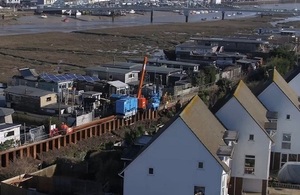
Giken piling train in Shoreham-by-Sea
The Environment Agency’s Adur tidal walls scheme in Shoreham-by-Sea is making great strides as it nears the final stages of construction with completion expected by the end of the year.
A major component to making good progress has been the use of the Giken press piling train to drive in the steel piles. This is a Giken silent piling unit, power pack, and crane mounted onto the piles (a ‘reaction stand’), using the installed piles as tracks – like a train. The Giken piler drives piles silently by pressing them into the ground. This is located at the front of the ‘train’ pressing piles in at the front. The whole train walks along, following the Giken silent piler to install piles in a linear fashion.
This equipment has proved to be key to working in the tight spaces between the Shoreham houseboats and the houses landside of the path, driving in the steel piles to form the wall’s core support.
The planning process needed to be carefully managed to ensure that stakeholder agreements were completed on time because of the specialist Giken press piling train required to install the sheet piles. This needed to be booked 6 months in advance as there are only a few in the world. Scheme contract partners Team Van Oord developed a stakeholder engagement programme to set out the process to obtain the agreements and the roles of project team organisations at each stage.
Following completion of sheet piling in the W5 reach*, the Giken train will be decommissioned on Thursday 2 August. The W5 reach is scheduled for reopening this autumn.
*The 7.2 kilometre long defence is split into 10 sections labelled as E for east or W for west of the river, ie E1, E2, E3, W1, W2, W3, W4, W5, W6, W7.
An Environment Agency spokesperson said:
We would like to thank everyone in Shoreham-by-Sea for their continued patience and support. More than two-thirds of the Shoreham Adur tidal walls flood defence scheme has now been completed. Having started construction in October 2016 we expect to finish by the end of this year.
A Team Van Oord spokesperson said:
In the W5 reach we have had to install some 1,176 sheet piles – each one 11 metres long. The work was complicated by being close to 40 houseboats along a stretch of 700m. However, we made sure to consult with stakeholders and houseboat owners keeping them informed on developments.
Thanks to their cooperation, we were able to continue the pile driving works in this reach without closing a larger area to the public.
Further information about the scheme is available on GOV.UK.
In addition, there is a dedicated visitor centre for the project, located in the Beach Green car park in Shoreham, and open from midday to 5pm Monday to Friday.
Contact details: email shorehamwestbank@environment-agency.gov.uk or write to:
SSD Enquiries
Environment Agency
Guildbourne House
Chatsworth Road
Worthing
BN11 1LD
For general information on how to prepare for flooding and the latest flood warnings in force please visit our floodline page or ring Floodline on 0345 9881188.
Notes to editors
The Shoreham Adur tidal walls scheme, made up of raised walls and embankments along the River Adur, is being constructed by the Environment Agency. Once complete, it will reduce the tidal flood risk to thousands of homes and commercial properties in the area, as well as protecting important local infrastructure such as roads, railway lines and Shoreham Airport. It is part of the Environment Agency’s 6-year plan to reduce the risk of flooding to at least 300,000 homes by 2020/21.
Adur tidal walls scheme in numbers
- 7.2km of defences
- 2,527 properties protected
- 2.5km of steel sheet piling
- 3km of flood embankment
- 1km of concrete walls
- ½km of flood glass
- ½km of rock revetment
- 2,316 lizards and slow worms relocated
- 14,000m2 saltmarsh habitat to be created
Other key points of the scheme
The scheme will reduce the risk of flooding to over 2,300 homes and 169 commercial properties. Consultation events in 2014 and 2015 provided public feedback on the designs now incorporated into the detailed designs.
The scheme boundary includes the nationally designated Adur Estuary Site of Special Scientific Interest (SSSI) and a RSPB reserve. These areas have over-wintering bird populations and significant areas of saltmarsh and mudflat. Saltmarsh and mudflat are priority habitats that have been identified as requiring conservation action under the Natural Environment and Rural Communities Act (2006).
The Environment Agency is aiming to minimise loss of saltmarsh habitat by moving the embankment next to the airport further back from its current position to create new saltmarsh habitat.