Draft MGN 687 (M+F) Safety of Navigation: methodology for assessing marine navigation safety and emergency response risks of fin/shellfish and seaweed/algal farms
Published 13 October 2026

© Crown copyright 2026
This publication is licensed under the terms of the Open Government Licence v3.0 except where otherwise stated. To view this licence, visit nationalarchives.gov.uk/doc/open-government-licence/version/3 or write to the Information Policy Team, The National Archives, Kew, London TW9 4DU, or email: psi@nationalarchives.gov.uk.
Where we have identified any third party copyright information you will need to obtain permission from the copyright holders concerned.
This publication is available at https://www.gov.uk/government/consultations/consultation-on-methodology-for-assessing-marine-navigation-safety-and-emergency-response-risks-of-finshellfish-and-seaweedalgal-farms/draft-mgn-687-mf-safety-of-navigation-methodology-for-assessing-marine-navigation-safety-and-emergency-response-risks-of-finshellfish-and-seaweed
Summary
This Marine Guidance Note highlights issues that need to be taken into consideration when assessing the impact on navigational safety and emergency response (search and rescue) caused by the placement of fin/shellfish and seaweed/algal farms. It applies to proposals in United Kingdom internal waters, Territorial Sea and Exclusive Economic Zone.
Key Points:
-
The placement of fin/shellfish and seaweed/algal farms in UK waters has the potential to affect shipping, safety, the freedom of navigation, and emergency response.
-
To deliver improved socio-economic objectives, a balance needs to be struck between minimising negative impacts on maritime safety whilst maximising the contribution of fin/shellfish and seaweed/algal farms to the economy. Although the concepts and operation of each sector are fundamentally different, the approach to assessing risk is the same with a proportionate approach applied.
-
This guidance has been produced to assist marine licence applicants in preparing their Navigation Risk Assessment (NRA) and emergency response arrangements for all types of fin/shellfish and seaweed/algal farms, and to identify the type and level of information that should be provided by the applicant. It includes templates that applicants may wish to follow in preparing their submission.
1. Introduction
1.1 This Marine Guidance Note intends to provide advice to fin/shellfish farms and seaweed/algal farm developers on the development of their methodology for assessing the navigational implications of their planned farm. This document aims to provide additional supporting information when putting together an application to the relevant Marine Licensing regulator, with the intention of streamlining the process for applicants.
1.2 The Maritime and Coastguard Agency (MCA) is a statutory consultee and/or primary advisor, depending on the relevant legislation (Table 1) to the marine licensing and offshore consenting regulators throughout the UK. We have an interest in all works associated with the marine environment, and the potential impact on the safety of navigation, access to ports, harbours and marinas and any impact on our search and rescue obligations.
Table 1: List of Marine Regulators
| Country | England | Wales | Scotland | Northern Ireland |
|---|---|---|---|---|
| Area from coast (in nautical miles) and legislation | 0-12nm & 12-200nm Marine and Coastal Access Act 2009 |
0-12nm & 12-200nm Marine and Coastal Access Act 2009 |
0-12nm – Marine (Scotland) Act 2010 12-200nm – Marine and Coastal Access Act 2009 |
0-12nm – Marine Act (Northern Ireland) 2013 12-200nm – Marine and Coastal Access Act 2009 |
| Licensing Authority | Marine Management Organisation | Natural Resources Wales | Marine Directorate Marine environment: licensing and consenting requirements - gov.scot | 0-12nm Department of Agriculture, Environment and Rural Affairs 12-200nm - Marine Management Organisation |
2. Background
2.1 Aquaculture sites are typically located inshore in sheltered areas, in varying depths of water usually up to 200m. They often consist of surface or sub-surface infrastructure and can be presented in a range of layouts depending on the design, which may include umbilical connections to shore or discharge pipes. These installations have the potential to be a direct risk to navigation and impact the marine environment, with the main considerations being:
- reduction in sea room that could lead to grounding,
- compression of traffic which could lead to collision,
- increased vessel movements contributing to collision risk,
- re-routing vessels around a farm,
- restricting access to sheltered anchorages,
- preventing the freedom of navigation through a site and
- constricting traffic or funnelling shipping.
2.2 This guidance aims to mitigate the risk to shipping and navigation and aims to ensure the risk is within the parameters of As Low As Reasonably Practicable (ALARP). It details the type and quality of evidence that MCA expects fin/shellfish farm and seaweed/algal farm marine licence applicants to provide to demonstrate that their project is well-considered with regard to navigational safety.
2.3 The recommendations in this guidance should be used to assess all reasonably foreseeable navigational scenarios where the siting, construction, extension, operation, or decommissioning of aquaculture infrastructure could create, or contribute to, an obstruction or danger to navigation or emergency response activities.
2.4 Marine licence applications are assessed on a case-by-case basis, taking account of site-specific circumstances and information. This guidance is not intended to provide a definitive or exhaustive list of requirements. Additional considerations, hazards, or risks may be identified during stakeholder consultation and will need to be taken into account as part of the assessment process.
2.5 Should navigational considerations not be suitably addressed, this may lead or result in delays or objections to development proposals on the grounds of navigation safety or emergency response preparedness.
2.6 So far as is reasonably practicable, all information supplied to MCA in connection with the criteria set out here should be supported by robust evidence and/or verification by independent third parties as appropriate.
3. Statutory Harbour Authorities
3.1 Statutory Harbour Authorities (SHA) are bodies responsible for navigation within localised areas of waterways, typically in and around areas of ports or harbours. It is important to distinguish early in the project lifecycle whether the area of development falls within a SHA, as this will determine which organisation will hold the relevant responsibility for the area.
3.2 Inside a Statutory Harbour Authority
3.2.1 Inside Statutory Harbour Authority (SHA) limits, the relevant harbour authority will have jurisdiction for the safety of navigation before and during construction, the operational lifespan, and the decommissioning of the farm. Applicants should discuss their proposals with the relevant SHA to obtain the relevant approvals and permits or works licences in addition to marine licensing requirements.
3.3 Outside a Statutory Harbour Authority
3.3.1 In the absence of an SHA, the responsible navigation authority is the MCA. The MCA must be reassured that the risks to vessel activity in the area have been fully assessed, relative to the scale of the works (for guidance on Proportionality, see section 6.4).
3.3.2 It is important to identify appropriate stakeholders for consultation, i.e. those who will have an interest in the effect on navigation and emergency response of the proposed development. It is important to give stakeholders the opportunity to provide their views on hazard identification, risk control options and risk tolerability. Applicants should aim to achieve agreement with stakeholders that risks in the hazard log are reduced to a level that is as low as reasonably practicable (ALARP).
3.3.3 Stakeholder groups may include representatives from the following sectors:
- commercial shipping, e.g. operators, associations,
- ports, harbours and marinas,
- recreation, e.g. Royal Yachting Association (RYA), sailing and recreational clubs,
- fishing associations,
- emergency response, e.g. local lifeboat rescue organisation,
- government agencies/departments and regulators, e.g. General Lighthouse Authority (GLA), Health and Safety Executive (HSE).
(Note: The above list of examples is not exhaustive. Appropriate stakeholders should be identified on a case-by-case basis.)
4. Fin/Shellfish and Seaweed/Algal Farms
4.1. Marine Licence Process
4.1.1 An applicant wishing to install a fin/shellfish and seaweed/algal farm would likely require a marine licence from the relevant Marine Licensing regulators (Table 1) for actions such as construction, alteration and improvement, or deposit of any substances or objects in the sea from a vehicle or vessel. Any marine licensing requirements should be discussed with the relevant regulator as per their guidance.
4.1.2 A marine licence application should be supported by appropriate technical information, such as site layout plans, equipment specifications, environmental assessments and a Navigational Risk Assessment (NRA). This MGN sets out guidance on the development and presentation of the NRA.
4.1.3 During the licensing process, the marine licensing regulator will consider any impacts on interference with other legitimate users of the sea, navigation safety and emergency response. They also ensure that applications are in line with all relevant international legislation and Marine Plans. Further information on the marine licensing process can be found through the appropriate marine licensing regulator websites.
4.1.4 In all cases, the MCA would expect applicants to have appropriate recovery arrangements for all the equipment and infrastructure for decommissioning of the farm, in all eventualities, including large-scale damage or bankruptcy. The seabed and water column must be returned to the original profile following the decommissioning. It is the responsibility of the applicant to ensure that the area is appropriately marked until made safe for other marine users.
5. Exemptions
5.1 In some cases, the proposed aquaculture sites may qualify for a Marine Licence Exemption, depending on a range of factors including the type, scale and location of the site. The relevant Marine Regulator (see Table 1) provides further guidance on the activities which may be exempt from a Marine Licence via their respective websites.
5.2 The applicant should confirm whether their activity falls within the scope of exempted activity but is reminded that any activity not meeting the exemption criteria will require a Marine Licence.
5.3 An applicant for an exempt activity is still required to present the details of their proposals along with a proportionate assessment on the navigational risks to the surrounding area with the suggested risk mitigation measures. This serves to demonstrate to the MCA that the risk to navigation has been considered and is ALARP and demonstrates to the relevant marine licensing regulator that positive engagement with the MCA has been undertaken.
5.4 Those seeking further guidance on Marine Licensing Exemptions are encouraged to contact the relevant marine licence regulator; however, the MCA would still expect consultation with the Marine Safety and PNT Services branch to determine the navigational risk of the proposed site.
6. Navigation Risk Assessment
6.1 This section aims to provide information on how to develop the NRA in a proportionate and suitable manner to demonstrate that navigational risks have been considered and properly mitigated to satisfy the ALARP requirement.
6.2 Navigation Risk Assessment Overview
In developing the NRA, the MCA recommends following the International Maritime Organization (IMO) Formal Safety Assessment (FSA) methodology, which is the internationally recognised approach for assessing impacts on shipping and navigation. The principles can be applied to any type or scale of works or development at sea, and this guidance note applies the principles for applicants to risk assess the scale of works to be undertaken in a proportionate manner.
As a minimum, the MCA would expect the NRA to contain the following (this is not an exhaustive list):
- the methodology used,
- description of the proposed development including the materials to be deployed, and the configuration of components,
- location depicted on a nautical chart, including latitude and longitude coordinates in WGS84 datum, and where possible, a shapefile or other GIS object (e.g. KML) must be provided (in WGS84 datum),
- description of the marine environment including identification of other marine infrastructure in the area,
- an analysis of local marine traffic, of both AIS data and locally sourced information to incorporate non-AIS vessels and an assessment of future traffic with the development in place,
- Assessment of emergency response and search and rescue,
- Risk matrix to define risk tolerability, Hazard log, and Risk control log (see section 7).
6.2.1 The MCA will consider each assessment on a case-by-case basis and will be prepared in principle to accept a change in scope, depth, tools and techniques resulting from the assessed risk as the full assessment progresses. Applicants are advised to contact the MCA as early as possible prior to developing the assessment.
6.2.2 An NRA must be submitted to support the Marine Licence application as required by the relevant Marine Licensing Regulator in the UK, to assess the impact and risk of the site to shipping, navigation and emergency response (see Annex 1). The Marine Licensing Regulator will then consult with the MCA, General Lighthouse Authority (GLA) and others as part of the formal marine licence consultation process on the suitability and acceptability of the NRA to ensure the risk to navigation is reduced to As Low As Reasonably Practicable (ALARP)[footnote 1] (see section 5.3).
6.2.3 The NRA should include the effect on navigation within the area proposed for the farm, plus the wider effects of vessel traffic transiting to locations outside of the immediate area of study (e.g. navigational squeeze and in-combination/cumulative impacts with other existing structures). The NRA should assess this for the periods of the construction, operational and decommissioning phases of the farm.
6.3 ALARP Principle
6.3.1 As Low As Reasonably Practicable (ALARP) is a risk management principle based on reducing risks to a level where further reduction would be disproportionate to the benefits gained. This would typically be due to factors like cost, time, or technological feasibility. In essence, ALARP involves a balance between the cost of reducing a risk and the benefit gained in terms of reduced harm or danger. A risk is considered ALARP when all possible measures to reduce it have been implemented, unless the cost of further mitigation is grossly disproportionate to the reduction in risk.
6.3.2 The outcome of a risk assessment would identify risk into the following three categories:
- Intolerable: risk reduction required regardless of cost,
- Tolerable, if ALARP: risk reduction measures applied, and relevant good practice in place,
- Broadly acceptable: relevant good practice in place.
6.3.3 When organisations are considering ALARP principles, they will need to carefully determine tolerability levels in terms of consequence and likelihood, which will help to set the level at which a risk may cross from broadly acceptable, to tolerable (if ALARP) to intolerable.
6.4 Proportionality
6.4.1 The scope and depth of the applicants assessment of navigational risk, together with the tools and techniques necessary to carry this out, should be relevant to the scale of the development and magnitude of the risks. Before applying for a marine licence, applicants are advised to:
- Inform the MCA of their proposals and seek guidance,
- Carry out a preliminary hazard analysis,
- Define an appropriate programme of work, including the methodology proposed to undertake the work, supplemented by diagrams where possible,
- Define the tools and techniques to be used,
- Be prepared to change scope, depth, tools and techniques resulting from assessed risk as the full assessment progresses.
6.5 Risk Assessment
6.5.1 The scope of the NRA should be discussed with the MCA on a case-by-case basis. As a minimum, the MCA would expect the items listed below to be considered for inclusion in the NRA:
a) Project details and scope – overview of the proposals including how the farm will sit in the water column, composition, materials, layout and dimensions. Farming, seeding and harvesting timescales, and methodology. Diagrams will be helpful.
b) The NRA must be based on a sound knowledge of the traffic densities and types. Therefore, the existing traffic baseline for the full site, including surrounding areas, is required. The traffic survey should include, as appropriate:
-
Automatic Identification System (AIS) data (class A and B) - at least 28 days of seasonal data (14 days peak summer and 14 days peak winter) and a desktop study with local consultation to ensure all vessel types found in the area, including personal watercraft, are captured. This should include traffic densities and type, other offshore infrastructure and any other navigational features (as seen on nautical charts etc). AIS data should be overlaid on nautical charts to give context and show navigational features in the area. AIS surveys may not be appropriate in all cases, particularly in remote locations that may only be visited by vessels and craft not carrying and operating AIS. In this instance, traffic surveys must include alternative sources of data and information, listed below.
-
Radar and visual surveys may be appropriate and should be considered according to location, scale of the project and vessel types in the area.
-
Other data sources to identify non-AIS traffic, such as recreational vessels (e.g. RYA Coastal Atlas), personal watercraft and smaller fishing vessels (e.g. Vessel Monitoring System).
-
The traffic study should be supported by local consultation with stakeholders.
c) A hazard log listing the hazards created or changed by the introduction of the farm and its associated equipment (see template in section 7.1);
d) A qualitative and/or quantitative assessment on the risks associated with the hazards during construction, operation and decommissioning:
- a risk control log (see template in section 7.2) including the risks, the risk mitigation measures, and the residual risk after applying suitable risk control measures,
- the tolerability of the residual risk (see section 7.6), and
- An ALARP declaration should then be stated.
e) An emergency response and Search And Rescue (SAR) overview, including the layout and access for service craft or emergency response vessels. This includes confirmation of the applicant’s ability to self-rescue and the availability of the standby vessel for use in an emergency. The emergency response arrangements should be detailed in the Marine Emergency Action Card and agreed with HM Coastguard in advance via oelo@mcga.gov.uk.
f) Monitoring, maintenance and inspection arrangements (including frequency) for the site and response times should any component break free. Where the proposed farm location is near to other projects or proposed projects in the vicinity, these should be considered cumulatively and in combination with each other in relation to shipping and navigation.
6.5.2 The MCA will assess all points above, as well as any other relevant supporting documents, to assess whether the claim that the risks associated with the site are ‘Tolerable’ based on the ALARP principle.
6.6 Tolerability of Individual Risks
6.6.1 Applicants should aim to achieve agreement with stakeholders that risks in the hazard log are reduced to a level that is ALARP. Failure to reach an agreement may result in delays or objections from stakeholders within the licensing process.
a) Risk
Each risk entered in the hazard log should be assessed against a risk matrix. Section 6 provides examples of risks and scoring. Other risk scoring systems may be used, and the techniques selected will need to be justified in the submission. There must be no unacceptable risks.
- All risks assessed as Tolerable with ‘x’ (e.g. scores 3 to 5, in table 7.4) shall be subject to an assessment of rule compliance and proposed risk controls. Further risk control options must be considered to the point where further risk control is grossly disproportionate (i.e. the ALARP principle) and an ALARP justification and declaration made.
b) Evidence
For each entry in the hazard log, the sources of evidence must be listed, e.g. expert judgement, quantitative calculations and the related risk scores justified.
c) Risk Controls
For each entry in the hazard log, the risk controls must be listed.
6.6.2 There is no generally accepted standard for a risk matrix. However, as a minimum, applicants will be expected to define the following as appropriate to their project: - likelihood/frequency of incident scenarios, - severity/consequence of incident scenarios, - risk matrix, - tolerability matrix scores.
6.7 Risk Mitigation Measures
6.7.1 Risk mitigation measures may include, but are not limited to:
- Aids to Navigation/lighting and marking arrangements as agreed with the relevant General Lighthouse Authority
- The publication of Maritime Safety Information by the UK Hydrographic Office (UKHO), and the update of nautical charts and publications
- Standby vessel for response to an emerging emergency
- GPS/AIS monitoring of equipment
- Third Party Verification of mooring arrangements (undertaken by an independent and suitably qualified assessor); and
- Marine Emergency Action Card
This list is simply a guide; the applicant should ensure all associated risks are suitably mitigated against to ALARP status.
Third-party verification is typically undertaken by an independent, competent, and suitably experienced individual or organisation to provide assurance regarding the quality of the design, fabrication, installation, and operation of the project. Third-party verification of the mooring arrangements is required prior to construction to provide assurance against the loss of infrastructure and is ideally secured through a condition of the marine licence.
6.8 Additional Information
6.8.1 The NRA should include detailed information of any consultation with local users or any consideration of the potential impact the site may have on vessels operating in the local area, including emergency response resources. It is beneficial to know if local consultation with users has been undertaken to ensure that the selection for the site is suitable and does not unsafely restrict vessels or impede access in any way.
6.8.2 The MCA would also like to ensure that consultation has been undertaken with the relevant General Lighthouse Authority regarding the lighting and marking of the site.
6.8.3 The MCA would expect the NRA to also detail the decommissioning arrangements once the site has reached the end of its operational lifespan.
6.8.4 Once the applicant has completed an NRA and submitted it as part of their marine licence application, the MCA will formally respond through the marine licence consultation process.
6.8.5 Notifications to local users and mariners must be issued and include the following organisations:
- The relevant local HM Coastguard zone (to be confirmed by MCA on a project basis) and oelo@mcga.gov.uk
- Marine Safety & PNT Services - navigationsafety@mcga.gov.uk
- Northern Lighthouse Board (Scotland and the Isle of Man) - navigation@nlb.org.uk (as appropriate)
- Trinity House (England, Wales and Channel Islands) – navigation@trinityhouse.co.uk (as appropriate)
- Irish Lights (Northern Ireland and Republic of Ireland) – operations@irishlights.ie
- Seafish - kingfisher@seafish.co.uk (as appropriate)
- Others as appropriate (commercial operators, fishing operators/groups and recreational groups, local ports and harbours).
6.9 UK Hydrographic Office (UKHO) Information
6.9.1 The UKHO is responsible for the timely promulgation of information to mariners such as national notices to mariners, navigational warnings, new editions of and updates to nautical charts and publications.
6.9.2 The UKHO acts as NAVAREA I Co-ordinator for the International Maritime Organization (IMO), the International Hydrographic Organization (IHO) World-wide Navigational Warning System and the UK National Co-ordinator for issuing coastal navigational warnings. The Radio Navigational Warnings (RNW) team within the UKHO will pass information to the appropriate co-ordinator should any activities fall outside of NAVAREA I.
Therefore, information must be submitted to the UKHO within set timescales as stated in marine licence conditions, by the marine licence holder to allow for the timely promulgation of information to mariners.
6.9.3 The UKHO should be notified of the relevant limits to be publicised, taking account of any restrictions that apply within one or more areas of the site.
6.9.4 The as-laid latitude and longitude coordinates in WGS84 datum must be supplied to the following email addresses:
7. Potential Incidents and Example Templates
There are direct and indirect impacts on activities and marine users during the construction, operational and decommissioning phases, including but not limited to: Potential incidents resulting from navigation activities
a) Collision - defined as a vessel striking, or being struck, by another vessel, regardless of whether either vessel is underway, anchored or moored; but excludes hitting underwater wrecks.
b) Allision/Contact – defined as a violent contact between a vessel and a fixed structure. Contact is defined as a vessel striking, or being struck, by an external object that is not another vessel or the sea bottom. Sometimes referred to as Impact. An under-keel clearance assessment may be appropriate to assess minimum water depths over infrastructure.
c) Grounding and Stranding - Grounding is defined as the ship coming to rest on, or riding across, underwater features or objects, but where the vessel can be freed from the obstruction by de-ballasting and/or assistance from another vessel (e.g. tug) or by floating off on the next tide. Stranding is defined as being a greater hazard than grounding and is defined as the ship becoming fixed on an underwater feature or object such that the vessel cannot readily be moved by lightening, floating off or with assistance from other vessels (e.g. tugs).
d) Foundering - to sink below the surface of the water.
e) Capsizing/sinking - the overturning of a vessel after attaining negative stability.
f) Fire/Explosion - Fire is defined as the uncontrolled process of combustion characterised by heat or smoke or flame or any combination of these. An explosion is defined as an uncontrolled release of energy which causes a pressure discontinuity or blast wave.
g) Loss of Hull Integrity (LOHI) - defined as the consequence of certain initiating events that result in damage to the external hull, or to internal structure and subdivision, such that any compartment or space within the hull is opened to the sea or to any other compartment or space.
h) Flooding/leaks/swamping - Flooding is defined as sea water, or water ballast, entering a space, from which it should be excluded, in such a quantity that there is a possibility of loss of stability leading to capsizing or sinking of the vessel.
i) Equipment failure/Machinery Related Accidents - Machinery related accidents are defined as any failure of equipment, plant and associated systems which prevents, or could prevent if circumstances dictate, the ship from manoeuvring or being propelled or controlling its stability.
j) Payload Related Accidents - includes loss of stability due to cargo shifting and damage to the vessel’s structure resulting from the method employed for loading or discharging the cargo. This category does not include incidents which can be categorised as Hazardous Substance, Fires, Explosions, Loss of Hull Integrity, Flooding accidents etc.
k) Hazardous Substance Accidents - defined as any substance which, if generated as a result of a fire, accidental release, human error, failure of process equipment, loss of containment, or overheating of electrical equipment, can cause impairment of the health and/or functioning of people or damage to the vessel. These materials may be toxic or flammable gases, vapours, liquids, dusts or solid substances.
l) Accidents to Personnel - defined as those accidents which cause harm to any person on board the vessel, e.g. crew, passengers, stevedores, which do not arise as a result of one of the other accident categories. Essentially, it refers to accidents to individuals, though this does not preclude multiple human casualties as a result of the same hazard, and typically includes harm caused by the movement of the vessel when underway, slips, trips, falls, electrocution and confined space accidents, food poisoning incidents, etc.
m) Accidents to the General Public and Shore Populations - defined as those accidents which lead to injury, death or loss of property amongst the population ashore resulting from one of the other ship accident categories.
7.1 Example Hazard List for Aquaculture Site
| Hazard Log | ||
|---|---|---|
| Number | Name/Type | Description |
| 1 | Collision | Vessels may collide with the working vessels due to poor visibility, navigational error, or adverse weather. |
| 2 | Entanglement | Vessels, particularly small craft or those with exposed propellers, can become entangled in cultivation lines, ropes, and mooring systems. |
| 3 | Reduced Manoeuvrability Space | Seaweed farms occupy surface and subsurface areas, restricting available sea room and forcing vessels into narrower transit routes. |
| 4 | Poor Visibility of Infrastructure | Marker buoys, lines, and submerged farm structures may be difficult to see, especially in low light, rough seas, or poor weather. |
| 5 | Allision | Vessels may strike buoys, floats, or support structures, causing damage to both the vessel and the farm. |
Note: This table is just an example of some risks and is not exhaustive. The applicant should work to ensure all conceivable risks are registered and acknowledged through these documents.
7.2 Example Risk Control List for Aquaculture Sites
| Risk mitigation Log | ||
|---|---|---|
| Number | Name/Type | Description |
| 1 | Notice to Mariners | Official communication issued to inform seafarers about changes, hazards, or important information affecting navigation. |
| 2 | Inform UKHO | Ensure that accurate, up-to-date navigational charts is available to mariners. |
| 3 | Layout design | Good layout design reduces risk at the source by ensuring vessels have enough space, clarity, and predictability to navigate safely. |
| 4 | Lighting and marking | Lighting and marking are used to make marine structures visible and identifiable to vessels, reducing navigation risk. |
| 5 | Guard Vessel | A Guard Vessel is used as a proactive, real-time risk control measure to protect both the development and passing vessels. |
Note: This table is just an example of some risks and is not exhaustive. The applicant should work to ensure all conceivable risks are suitably mitigated and acknowledged through these documents.
7.3 Example Frequency and Severity Index Table
| Frequency Index | |||
|---|---|---|---|
| Frequency Score | 1 | Rare / Improbable | Almost impossible; expected to occur less than once in 100+ years |
| 2 | Unlikely / Remote | Unlikely to occur, though possible under exceptional circumstances | |
| 3 | Possible / Occasional | Might happen occasionally; it is not expected, but it is entirely possible | |
| 4 | Likely / Probable | Will occur several times during the lifecycle of the project or asset | |
| 5 | Almost Certain / Frequent | Expected to happen consistently or multiple times a year |
| Severity Index | |||
|---|---|---|---|
| Severity Score | 1 | Insignificant | Hazard will not result in serious injury or illness, or has a remote possibility of damage |
| 2 | Minor | Hazard could cause illness, injury, or equipment damage, but its effects would not be serious | |
| 3 | Moderate | Hazard can result in serious injury or illness, property or equipment damage | |
| 4 | Major | Hazard can result in serious injury or illness, property or equipment damage | |
| 5 | Critical / Catastrophic | Hazard is capable of causing death and illness |
Note: These tables are just an example. The applicant should consider all sections relevant to their proposal.
7.4 Example Risk Matrix Table
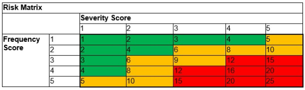
Example Risk Matrix Table
7.5 Example Tolerability Matrix Table
| Tolerability Matrix | ||
|---|---|---|
| Risk Matrix Score | Tolerability | Explanation |
| 1 to 4 | Broadly Acceptable | A technical review is required to confirm that the risk assessment is reasonable. No further action is required |
| 5 to 10 | Tolerable with Additional Controls | A Hazard is currently too high to proceed without changes, but it can be managed to an acceptable level if you implement extra safety measures. |
| 11 to 25 | Unacceptable | A hazard’s potential impact and likelihood are too high to justify the activity under current conditions. |
Note: These tables are just an example. The applicant should consider all sections relevant to their proposal.
7.6 Example Risk Assessment Table
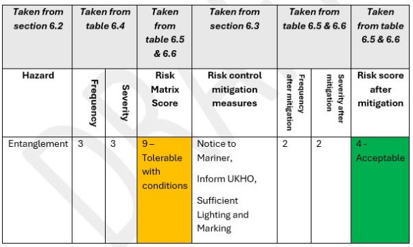
Example Risk Assessment Table
Note: The above example is purely for illustration purposes as to how sections 6.2 to 6.6 could be applied together and is not to be directly used in any application. Each application should calculate their own risks, conditions and matrix.
8. Emergency Response
8.1 Marine Emergency Action Card (MEAC)
8.1.1 As the maritime emergency service in the UK, HM Coastguard requires specific content to be included within the Marine Emergency Action Card (MEAC):
- Summary and description of the site, including location (on a nautical chart), components and dimensions (pictures and/or diagrams), should support a description.
- Contact information including emergency phone number, backup number and any radio frequencies used. Contact email address(es) should also be included.
- Any emergency response structure to be established, including key roles.
- Vessel information, including any vessels permanently contracted/owned by the farm or the types which may be in attendance, including communication information and role.
- If vessel crew have emergency beacons, i.e. Personal Locator Beacons (PLBs), information should be included on the type of beacon and how further information can be gathered, e.g. via the above-listed emergency contact number.
- Monitoring information (which may include vessels detailed above), including any shore-based detection systems (e.g. radar, AIS) and communication capabilities.
- Any hazard markings and/or lights, particularly those on the coast or which may be visible from sea.
- Any pollutants and/or environmental hazards which could pose a risk to emergency responders, the coastline and/or marine environment, including response options.
- HM Coastguard information including nearest MRCC, nearest SAR resources and contact information including telephone and email.
- NOTE: The coastguard should be immediately notified via 999 if a life-threatening emergency occurs.
- Any additional information which may be useful to HM Coastguard.
- It may be beneficial to include a notification diagram and/or flowchart to demonstrate how the emergency notifications will happen.
8.1.2 Any contact information contained in the MEAC and provided to the MCA will be used solely for the purposes of emergency response as part of the Agency’s functions. The information will be kept securely and will not be used for any other purpose without permission from the information provider. The information will be stored by the MCA until the company provides updated information or the farm ceases to exist, at which point the information will be deleted. ##9. Review of Procedure and Good Practice
9.1 This guidance will be reviewed annually to ensure it remains fit for purpose and evolves with the aquaculture industry. The review will consider improvements, concerns and items of good practice with a view to updating, refining and improving guidance and procedures for mitigating risk in the marine environment for fin/shellfish and seaweed/algal farms in the future.
More information
Marine Safety and PNT Services
Maritime and Coastguard Agency
Bay 2/24
Spring Place
105 Commercial Road
Southampton
SO15 1EG
Telephone: 020 3817 2000
Email: navigationsafety@mcga.gov.uk
Website: www.gov.uk/mca
-
Descriptions of ALARP can be found in: a) Health and Safety Executive (2001) ‘Reducing Risks, Protecting People’b) IMO (2018) MSC-MEPC.2/Circ.12/Rev.2 dated 9 April 2018, ‘Revised Guidelines for Formal Safety assessment (FSA) in the IMO Rule-Making Process’ ↩