National Model Design Code: part 1 - the coding process (html accessible version)
Updated 14 October 2021
Applies to England

© Crown copyright 2021
This publication is licensed under the terms of the Open Government Licence v3.0 except where otherwise stated. To view this licence, visit nationalarchives.gov.uk/doc/open-government-licence/version/3 or write to the Information Policy Team, The National Archives, Kew, London TW9 4DU, or email: psi@nationalarchives.gov.uk.
Where we have identified any third party copyright information you will need to obtain permission from the copyright holders concerned.
This publication is available at https://www.gov.uk/government/publications/national-model-design-code/national-model-design-code-part-1-the-coding-process-html-accessible-version
Purpose
1. The purpose of the National Model Design Code is to provide detailed guidance on the production of design codes, guides and policies to promote successful design. It expands on the ten characteristics of good design set out in the National Design Guide, which reflects the government’s priorities and provides a common overarching framework for design.
2. The National Planning Policy Framework (NPPF) makes clear that all local planning authorities should prepare design guides or codes consistent with the principles set out in the National Design Guide and National Model Design Code, and which reflect local character and design preferences. Design codes and guides should provide a framework for creating high-quality places.
3. It also makes clear that the geographic coverage, level of detail and degree of prescription should be tailored to the circumstances and scale of change in each place, and should allow a suitable degree of variety.
4. The tools, processes and outputs described in this guidance can be applied to the range of design advice produced by local authorities, including design codes and design guides. The content and level of detail in design codes or design guides will vary according to the scale at which a code is applied, whether at county, local authority, neighbourhood or site level. For example, for a site with a masterplan and vision the code should be detailed and specific whereas a county-wide code may be high level.
5. A design code is a set of simple, concise, illustrated design requirements that are visual and numerical wherever possible to provide specific, detailed parameters for the physical development of a site or area. This guide is a toolkit to guide local planning authorities on the design parameters and issues that need to be considered and tailored to their own context when producing design codes and guides, as well as methods to capture and reflect the views of the local community from the outset, and at each stage in the process.
6. The National Model Design Code forms part of the government’s planning practice guidance and should be read as part of the National Design Guide, and alongside the planning practice guidance notes referenced in Part 3 of the National Design Guide, Manual for Streets, and other forthcoming guidance relating to the natural and environmental characteristics of development. This guidance is not a statement of national policy, however, the government recommends that the advice in this guidance on how to prepare design codes and guides is to be followed.
Objectives
7. This guidance sets out clear design parameters to help local authorities and communities decide what good quality design looks like in their area, based on local aspirations for how their area will develop, following appropriate local consultation.
8. The National Model Design Code sets out design considerations which local planning authorities will be expected to take into account when developing local design codes and guides and when determining planning applications.
9. Design codes are important because they provide a framework for creating healthy, safe, green, environmentally responsive, sustainable and distinctive places, with a consistent and high-quality standard of design. This can provide greater certainty for communities about the design of development and bring conversations about design to the start of the planning process, rather than the end. The built environment has a significant impact on people’s health and wellbeing. It needs to feel safe and secure for all including those who could be vulnerable. Creating more beautiful places requires a greener approach that supports progress towards our national environmental goals. This means more energy efficient buildings, enhancing nature, integrating with the natural environment creating more resilient places and delivering progress towards to the net zero carbon target by 2050.
10. The government understands that quality design does not look the same across different areas of the country, for instance, that by definition, local vernacular differs and design priorities differ for scale and types of development.
11. The National Model Design Code sets a baseline standard of quality and practice which local planning authorities are expected to take into account when developing local design codes and guides and when determining planning applications, including:
- How the design of new development should enhance the health and wellbeing of local communities and create safe, inclusive, accessible and active environments
- How landscape, green infrastructure and biodiversity should be approached including the importance of streets being tree-lined
- The environmental performance of place and buildings ensuring they contribute to net zero targets
- The layout of new development, including infrastructure and street pattern
- The factors to be considered when determining whether façades of buildings are of sufficiently high quality, and
- That developments should take account of local vernacular, character, heritage, architecture and materials.
12. Design codes can provide a more specific steer on what is acceptable when they are visual and numerical rather than relying on detailed policy wording, as well as being easier to engage with. They can also give developers greater certainty about what may be acceptable when seeking planning permission, and can help lead to faster decisions based on whether a proposal complies with a code, which can help to speed up the delivery of development.
13. For larger schemes, such as phased developments, design codes can help to maintain consistency in the delivery of development over a longer period of time. Codes also set out a necessary level of detail in sensitive locations, for example, with heritage considerations, and they can set out specific ways to maintain local character. Design codes and guides can also be helpful in facilitating custom and self-build. They can help facilitate the use of modern methods of construction and should not constrain technical and environmental innovation.
14. When preparing design codes and guides, communities need to be involved in the process in order to gain measurable community support that is appropriate for the scale and location of new development. Design codes should be prepared in light of information about what is popular locally, on the basis of evidence. This will address the ambition in a new planning system to bring democracy forward so that communities decide what good design means locally and that this is enshrined in design codes and guides.
15. The National Planning Policy Framework sets out that the National Design Guide and National Model Design Code should be used to guide decisions on applications in the absence of locally produced guides or codes. These documents provide guidance on what constitutes well-designed and beautiful places as well as providing a default checklist of issues that schemes will be expected to address.
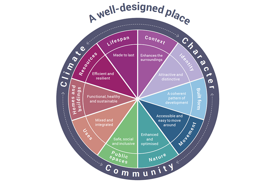
Ten characteristics of well-designed places. (National Design Guide extract).
[Alt text: An image of an infographic extracted from the National Design Guide, which shows the 10 characteristics of well-designed places. These are shown as a coloured pie chart made up of the following “slices”:
- Mid tone purple: Context
- Light purple: Identity
- Light blue: Built form
- Dark blue: Movement
- Dark green: Nature
- Light green: Public Space
- Light orange: Uses
- Dark orange: Homes and buildings
- Dark raspberry: Resources
- Dark purple: Lifespan ]
Application
16. This document should be used as a basis for the production of design codes and guides by local planning authorities. It contains information that should be readily available to the local authority and is intended to be applied flexibly according to local circumstances as not all characteristics and design parameters may be relevant.
17. The document provides design guidance and needs to be used alongside the National Design Guide to inform local design guides and codes as well as decisions on planning applications. The area covered by the design code and the level of detail is to be determined locally. A coding plan will be needed to show the area covered by the code or guide. There is an option to use area types so that the guidance can be adjusted to reflect local character. The commentary in Part 2 provides a checklist of content for design guidance or policies that local authorities may consider including in their local plans if a design code is not appropriate.
18. The National Model Design Code and Guidance Notes is to be applied with simple clear requirements according to local circumstances recognising that not all content may be relevant. Design guides and codes should provide clear parameters within which there is scope for flexible application to allow for innovation. Local authorities will be aware of the need to ensure that design guides and codes are updated over time as social, technical and environmental circumstances change and subject to support from local communities.
19. The National Planning Policy Framework is clear that design policies should be developed with local communities, so they reflect local aspirations. Local authorities should also collaborate with developers and landowners on design codes, particularly in relation to specific sites. Developers and landowners may also choose to prepare their own design code in support of a planning application in collaboration with local authorities and communities, following the principles set out in the National Model Design Code and the National Design Guide.
20. The National Planning Policy Framework is also clear that local planning authorities should develop an overarching design vision and expectations that can inform design codes, guides and other tools that inform the design of the built and natural environment in their area, whether prepared by them or other parties. Local planning authorities should follow the advice in the plan making Planning Practice Guidance, particularly when producing design codes or guides as a supplementary planning document. Planning Practice Guidance Design: Process and Tools sets out guidance on design review and other design assessment approaches which should be considered when developing codes.
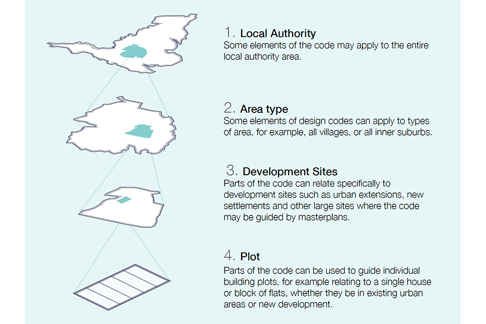
[Alt text: This infographic illustrates the possible areas that elements of a design code might cover.
It shows a series of four simplified maps, stacked vertically from the largest area (England) down to the smallest area (a plot for a single building), with the following accompanying captions:
1. Local Authority. Some elements of the code may apply to the entire local authority area.
2. Area type. Some elements of design codes can apply to types of area, for example, all villages, or all inner suburbs.
3. Development Sites. Parts of the code can relate specifically to development sites such as urban extensions, new settlements and other large sites where the code may be guided by masterplans.
4. Plot. Parts of the code can be used to guide individual building plots, for example relating to a single house or block of flats, whether they be in existing urban areas or new development. ]
Coding process
21. The process of preparing a local design code is based on the following seven steps:
1. Analysis
1A - Scoping: Agreeing on the geographical area to be covered by the code and the policy areas that it will address. 1B - Baseline: Bringing together the analysis that will underpin the code and inform its contents.
2. Vision
2A – Design vision: Dividing the area covered by the code into a set of typical ‘area types’ and deciding on a vision for each of these area types. 2B – Coding plan: Preparing a plan that maps out each of the area types and also identifies large development sites from allocations in the local plan. 2C – Masterplanning: On larger sites working with land owners and developers to agree a masterplan for each of the development sites establishing the key parameters and area types.
3. Code
3A – Guidance for Area Types: Developing guidance for each area type by adjusting a set of design parameters. 3B – Code Wide Guidance: Agree on a set of policies that will apply equally across all area types.
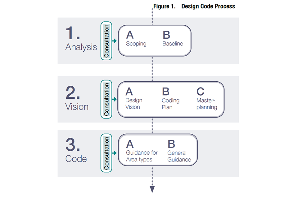
Figure 1. Design code process.
1.A Scoping
22. The first step is to decide on the scope of the code, in particular which parts of the local area it needs to cover, and which policy areas it addresses.
Coverage
23. In terms of geographical coverage some authorities may wish to create a code that covers their entire area. Codes may cover all existing built-up areas, or just new development sites. The options are therefore that the code covers:
- The whole local authority area including all existing settlements and development sites.
- Selected parts of existing settlements and development sites.
- Just development sites.
24. There are benefits in having a single design code covering one of the above options, rather than having separate design codes for each site.
Content
25. The guidance notes include many of the potential issues that might be covered by a design code. These are organised under the ten headings of the National Design Guide and include sub-headings. Codes are not expected to cover all of these issues, and the context and scale of development will determine the appropriate issues that need to be included.
26. Some design parameters are an essential component of design codes for their effective use such as movement pattern, built form, height, land use, character of buildings and public spaces, open space and density while others are discretionary (see Figure 2). The latter include, for example, housing standards that are crucial but may be dealt with elsewhere in local plans.
27. Design codes would be expected to include the following:
- Context - Local character and built heritage.
- Movement - Design of the street network, active travel and public transport.
- Nature - Design of green infrastructure, play spaces, SUDS and the protection of biodiversity.
- Built Form - Density, built form and urban design.
- Identity - character of buildings.
- Public space - Design and of streets and public spaces.
- Homes and Buildings - Type and tenure of homes.
- Uses - Mix of uses and active frontage.
- Resources - Environmental design, renewable energy provision and low energy networks.
- Lifespan - Management and adoption standards.
Other related issues referred to in the National Model Design Code can be covered either in a Code or in other policies in local plans.
28. Some issues will depend on the decision about the coverage of the code. Codes that cover larger schemes will need to include guidance on creating a new street network, public transport routes, planning and designing green spaces and providing schools and other facilities. By contrast in existing built-up areas where the street network etc. already exists, these elements of the code will be less relevant (see Figure 2).
Consultation
The scoping stage should include the development of a consultation strategy for the code based on the guidance set out in the community engagement section of the guidance notes to determine what is popular locally based on evidence from engagement and consultation.
The community engagement process will be heavily dependent on the geographical coverage of the code and the extent to which it applies to existing settlements. This in itself should be the subject of an initial consultation exercise that will:
- Provide briefing and training to community groups involved with the built environment about what a code is and how it is developed.
- Discuss with the groups who wish to be involved, what the code should cover.
The results of this initial engagement will feed into a consultation strategy that will include the stages at which consultation will take place, what techniques will be used and how the community will be engaged.
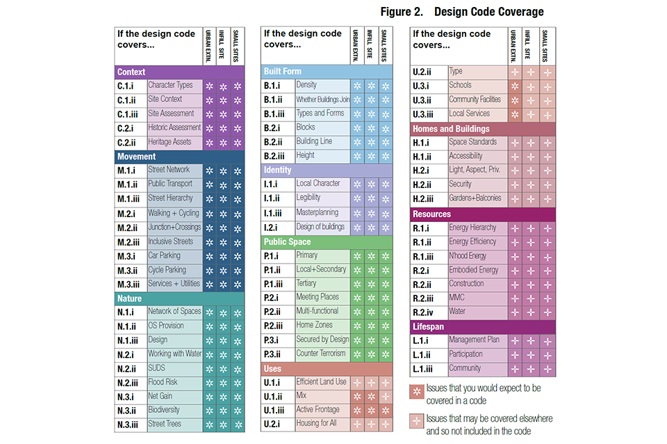
Figure 2. Design code coverage.
[Alt text: This table sets out the issues that you would expect a design code to cover, and the issues that may be covered elsewhere in policy, and so may not be included in a code.
The table is arranged by the 10 characteristics (Context, Movement, Nature, Built Form, Identity, Public Space, Uses, Homes and Buildings, Resources and Lifespan). For each of these it indicates likely code content for three different scales: an urban extension, and infil site, and a small site.
For the first six characteristics, all the relevant issues are expected to be covered at every scale. For “uses” most of the characteristics are expected to be covered at the three scales. For Homes and Buildings, Resources and Lifespan, most of the issues are likely to be covered in other policy, so they won’t always need to be required in codes.]
1.B Baseline
29. Design codes need to be based on an analysis of the area covered. The purpose of the analysis is to understand the area and inform a vision that will, in turn, form the basis for the code.
30. Local planning authorities will need to have an understanding of their area informed by up-to-date evidence such as characterisation studies or site analysis, with input from the community, to support design coding. Local planning authorities may already hold this information, so it is possible that they will not need to carry out further analysis for the purpose of producing a design code. The analysis could include:
- Topographical, geology, ecology, river and waterways, flood risk.
- Landscape character including wider area.
- Open space and green infrastructure.
- Local character.
- Heritage and culture assets, including conservation areas.
- Land use, economic uses.
- Built form, density, massing.
- Community infrastructure and schools.
- Public transport accessibility.
- Road/street hierarchy.
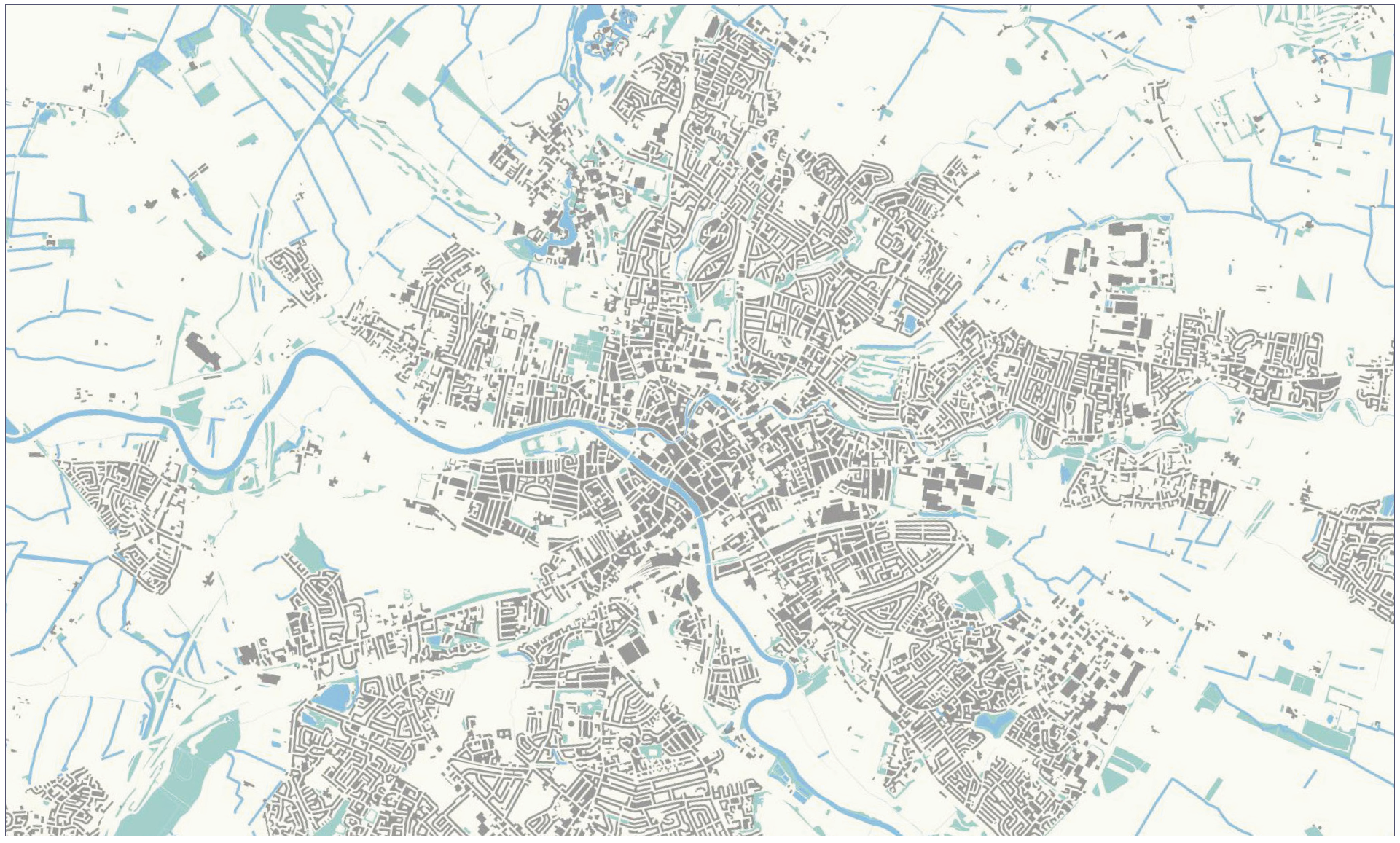
Figure 3. Figure Ground Plan: A set of analysis plans can help understand the local area and inform area types described on the following pages.
31. This analysis will feed into the identification of the ‘area types’ described in the next two steps as well as providing a baseline on issues such as street hierarchy, open space provision, public transport and community facilities that will inform elements of the code.
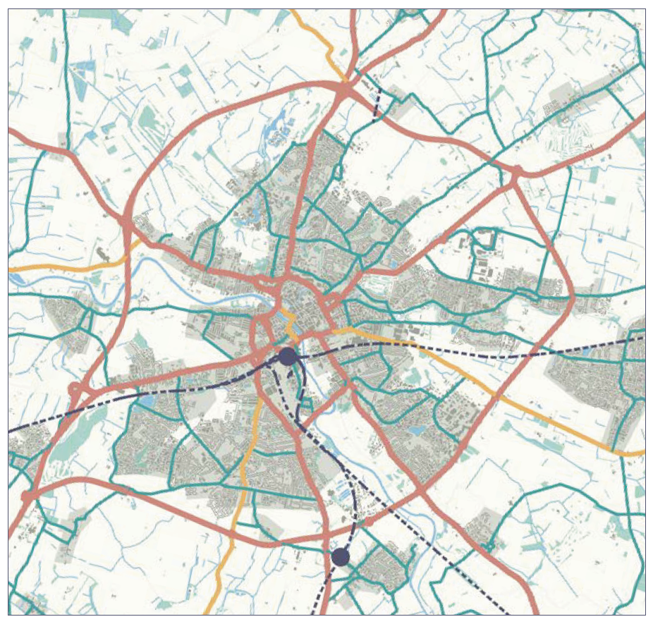
Figure 4. Street Hierarchy: Parts of the design code relate to the character of different street types. This would be facilitated by classifying all of the streets of the local area on the basis of a street hierarchy. This can be done by identifying primary streets and secondary streets, the remainder being local streets.
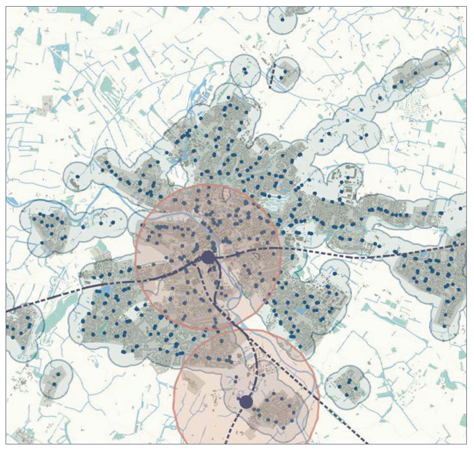
Figure 5. Transport Accessibility: Parts of the design code may allow an increase in densities or building heights in areas of high public transport accessibility. If this is the case, it will be important to have a plan showing public transport accessibility such as a public transport accessibility level plan or equivalent.
[Alt text: Transport Accessibility. The illustration shows a transport accessibility plan of a fictional mid-sized town. Bus stops are illustrated by a dark blue point, surrounded by a blob indicating an 800 meter walking distance. Train stations are illustrated with a black point, surrounded by a larger red blob. This indicates the larger distance people are willing to travel to by walking and cycling to reach a train station. ]
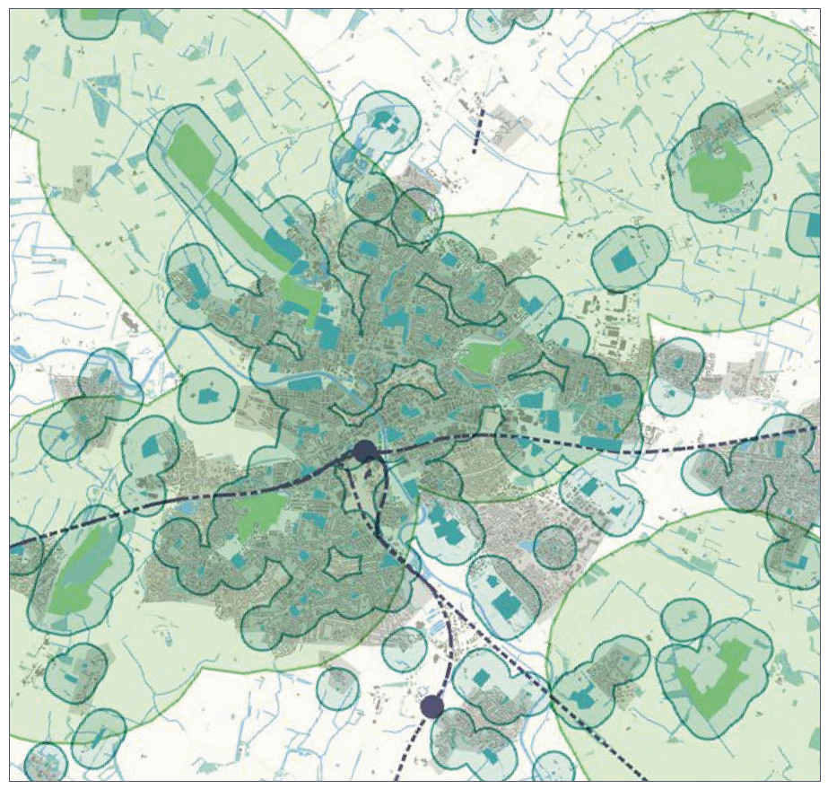
Figure 6. Open Space Provision: The Nature section of the design code relates to open space provision, ecology, green and blue environments and their resilience. There may be value in having an authority wide plan showing each type of open space and natural designations and their relevant proximity zones.
[Alt text: Open Space Provision. The illustration shows an open space plan of a fictional mid-sized town. Large green spaces are shown in light green and smaller green spaces are shown in dark green. Blobs drawn around the green spaces illustrate accessible natural green space standards, which state, for example, that people should have access to green space of a certain size within 5 minutes walk of their home.]
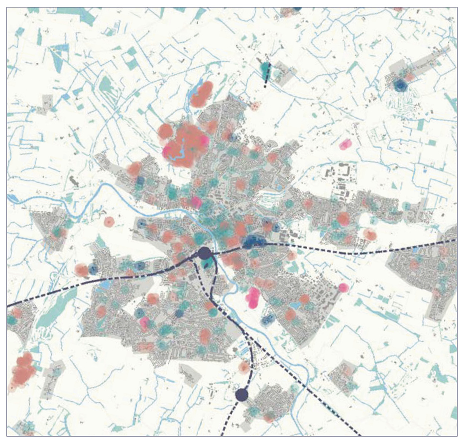
Figure 7. Land Use Pattern: The use section of the design code relates to land use pattern, including cultural spaces, schools and other community facilities and again it may be useful to have an authority-wide plan showing the location of existing facilities.
2.A Design vision
32. Design codes need to be based on a vision for how a place will develop in the future, as set out in the local plan. This vision needs to be developed with the local community and is likely to be an important part of the community engagement process.
33. Local planning authorities should create a vision statement which sets out the specific aims for the design code. These visions need to be aspirational and set the context for the subsequent development of the code covering:
- An appreciation of the existing area or site, its natural, topographical, historical and heritage features.
- Its character and appearance.
- The mix of uses and facilities.
- The amount of green infrastructure and character of green space.
- The way in which it deals with traffic, parking, public transport, walking and cycling.
- Sustainability including energy efficiency, net zero alignment and climate resilience.
Identifying area types
34. When preparing a design code for the whole local planning authority area, one approach is to divide the existing built-up area to be covered by the code into area types. These are areas of character that will be used to set common parameters in the code. If the code is covering a small area, then this stage may not be necessary. However, many places will include a number of different area types which will need to be analysed and mapped.
35. Area types can be identified through characterisation studies, GIS analysis or a combination of these and the experience of planning officials and local communities.
36. Area types are based both on the existing character of the place and how the local authority and community expect the area to develop in the future. In Step 2B we describe ten possible area types as a starting point. Few areas will include all of these types.
37. The area types should be analysed using a standard worksheet (See Fig 8). This is something that can be done as part of consultation events with local communities. This analysis will feed into a vision for what that area type should become in the future.
Consultation
The design visioning process will be an important focus for consultation. This could be undertaken through a series of workshops across the local area that involve communities and stakeholders in the analysis of existing character and visioning of how this character may change.
Wider surveys are likely to be necessary to ensure widespread local input beyond workshop attendees. This can include ‘walking workshops’, photographic surveys and visual preference surveys and sustainability/ environmental surveys to understand the aspects of local character that people value and those that they would like to change.
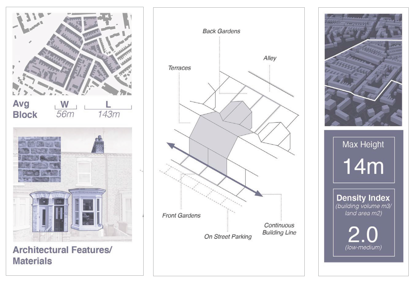
Figure 8. Extracts of Example Area Type Worksheet. See guidance notes appendix for template.
[Alt text: The image is an infographic showing extracts of what an Area Type Worksheet could look like. The contents include:
- a diagram showing the average block size.
- photos of key architectural features and materials (in this case, red brick and prominent bay windows).
- A drawing showing the building line, set back and garden arrangement.
- A 3D plan showing heights and density. ]
2.B Coding plan
38. The analysis will feed into a plan similar to Figure 9, that shows the areas of the authority to which the code will apply along with the distribution of the area types. The plan also shows major development sites based on local plan allocations that will be subject to the masterplanning exercise in Step 2c.
39. The existing built-up area to be covered by the code needs to be identified as an area type or a mixture of area types as illustrated in Figure 10.
40. Some places will include only a few area types, and some may include examples of all ten types. A limited number of area types should be identified to avoid the design code being too complex.
41. Area types can include other uses, such as a small factory or school within a suburban area type. The principle being that, if that site came up for development, then it would be appropriate to be guided by the identified area type.
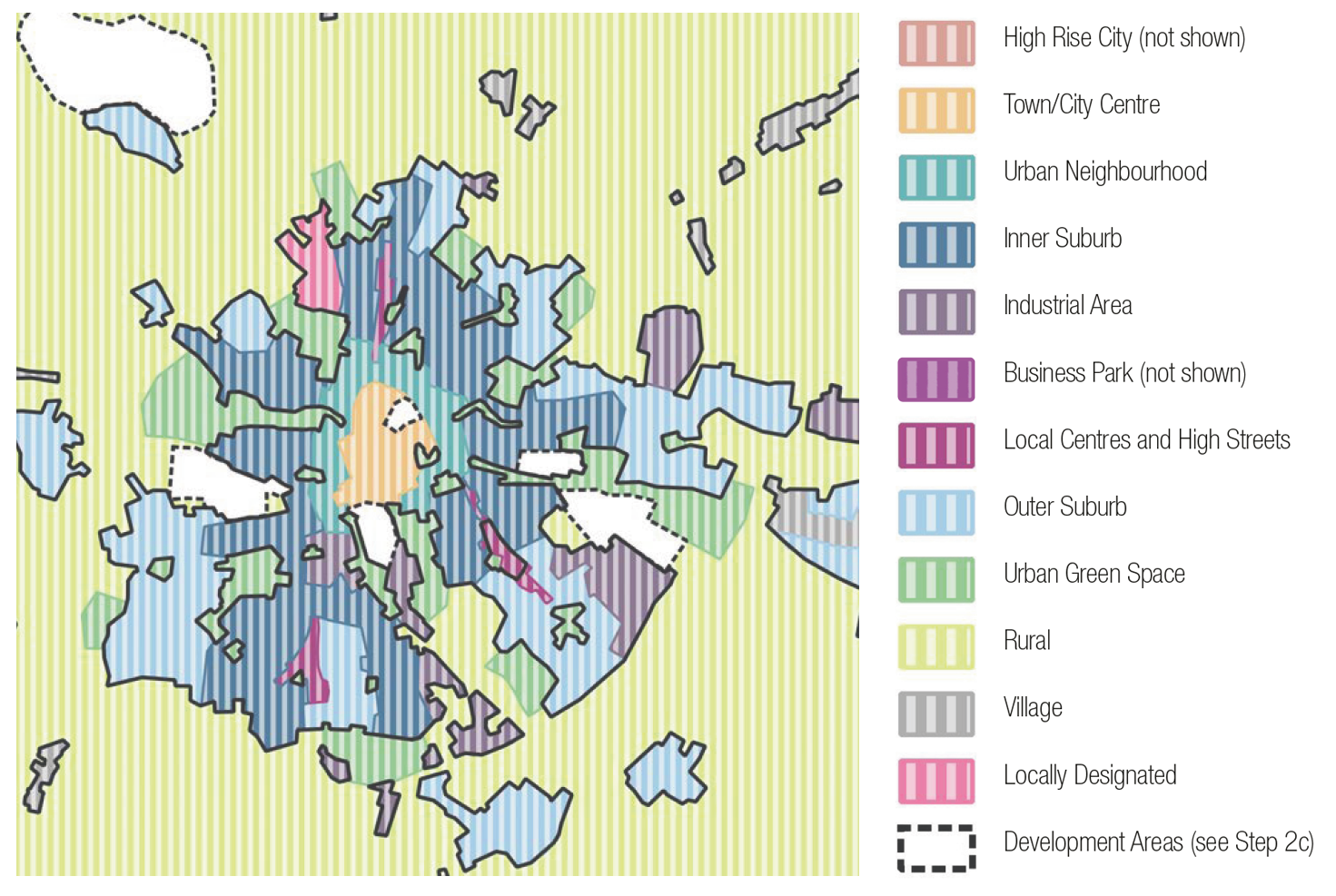
Figure 9. Coding Plan: This plan shows the area to be covered by the code and divides this up into a series of area types as described opposite. Most places will not include all of these area types, and some may include types that fall outside all of these examples.
[Alt text: This is an illustrative map of a fictional mid-sized town, with different areas coloured according to the area type that has been assigned. The map has been produced using a set of example area types, developed for this document. They include the following types. Descriptions are given for these in the following text]
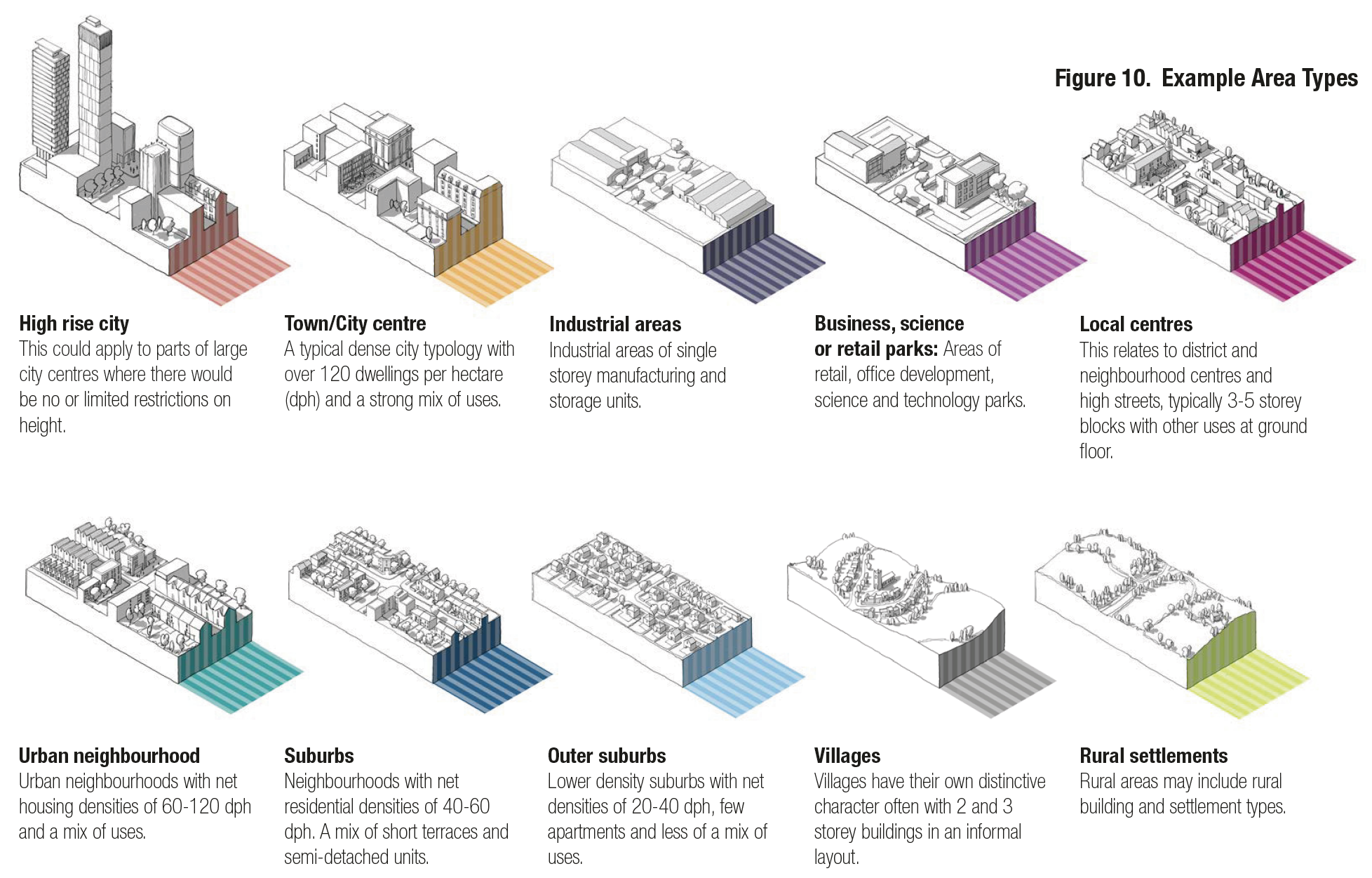
Figure 10. Example Area Types
High rise city. This could apply to parts of large city centres where there would be no or limited restrictions on height.
Town/City centre. A typical dense city typology with over 120 dwellings per hectare (dph) and a strong mix of uses.
Industrial areas. Industrial areas of single storey manufacturing and storage units.
Business, science or retail parks. Areas of retail, office development, science and technology parks.
Local centres. This relates to district and neighbourhood centres and high streets, typically 3 to 5 storey blocks with other uses at ground floor.
Urban neighbourhood. Urban neighbourhoods with net housing densities of 60 to 120 dph and a mix of uses.
Suburbs. Neighbourhoods with net residential densities of 40 to 60 dph. A mix of short terraces and semi-detached units.
Outer suburbs. Lower density suburbs with net densities of 20 to 40 dph, few apartments and less of a mix of uses.
Villages.Villages have their own distinctive character often with 2 and 3 storey buildings in an informal layout.
Rural settlements. Rural areas may include rural building and settlement types.
2.C Master planning
42. If a design code is being prepared for larger sites, it may be necessary to produce a masterplan as part of the design coding exercise. This masterplan will establish a new street network, decide which area types apply, along with various other parameters.
43. These development sites will usually have been allocated in the local plan and will generally be larger sites. Smaller sites can be dealt with within the area type framework.
Who is responsible?
44. The coding framework for development sites can be produced by the local planning authority or the landowner/developer in partnership with a local planning authority. This would be done when the site is allocated for development in the local plan and included in a design code.
What the masterplan includes:
45. Figure 11 shows a notional masterplan for one of the development sites identified on the coding plan in step 2b. The level of detail will vary depending on whether the authority or developer is preparing the masterplan and the complexity of the site. It will also depend on where the site is in the planning process – local plan preparation, pre- application, community consultation, outline or detailed application stages. Landscape can be a major driver in a design process at masterplanning scale. The exercise may include an illustrative masterplan that shows what the area could be like in the future for the purposes of consultation, but the detailed plan would be illustrative.
Consultation
The masterplanning exercise for development sites needs to be subject to a separate community engagement exercise. This will need to be co- ordinated with the consultation on the local plan allocation as well as consultation being undertaken by the owner/developer.
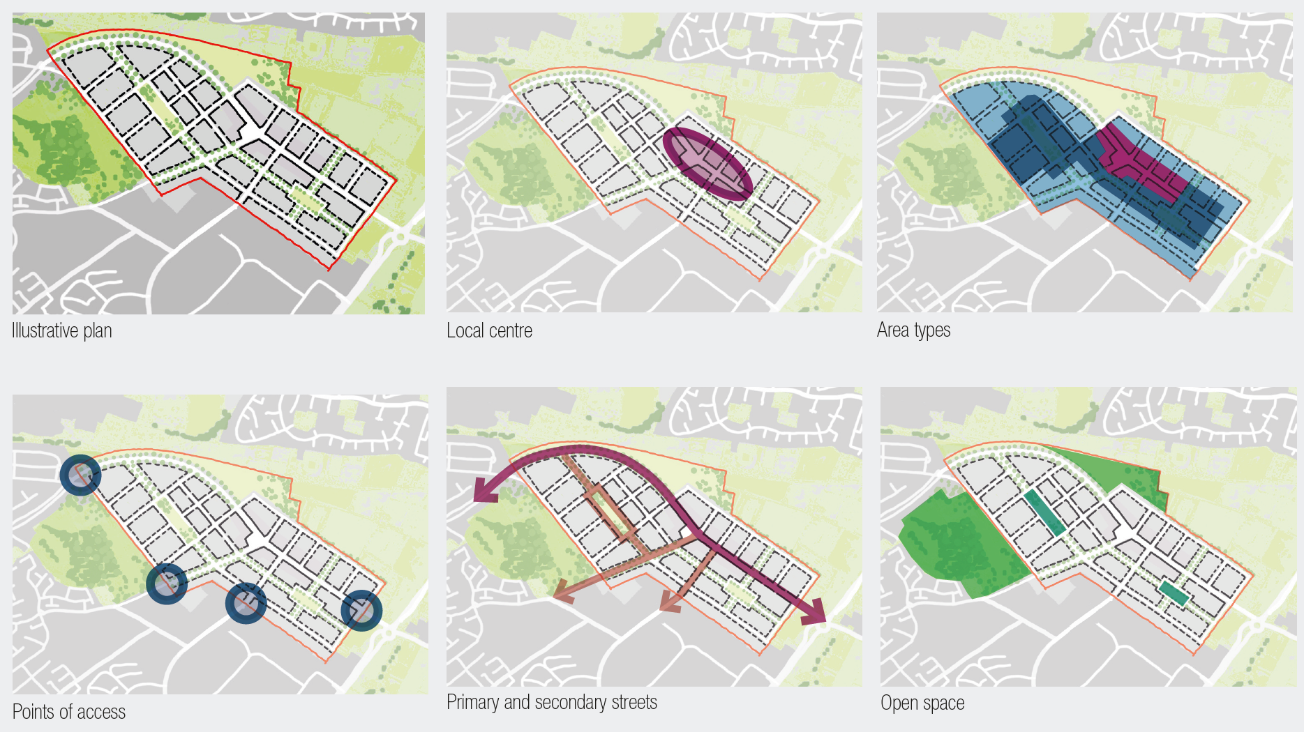
Figure 11. Development Site Masterplan
[Alt text: This series of diagrams relate to the Figure 11 text on the previous page. The diagram series takes an example development site from the coding plan in Stage 2B and shows the key masterplanning principles that might be applied. For example: an illustration of the block structure, the location of a local centre, the location of different area types, the key points of access, the primary and secondary streets, and the location of open spaces.]
The aim of the masterplan is to provide a framework for the application of the design code to the site. This is likely to include:
- The landscape strategy, taking account of existing natural features of the site and wider area, biodiversity and new structural elements.
Green infrastructure including the amount and position of open space provision.
- The number, type and tenure of homes and other uses (from the local plan allocation).
- The points of access and connection to the wider street network.
- The broad position of the primary and secondary streets but not local streets.
- The position of the local centre if relevant.
- The area types that will apply to different parts of the site (which will in turn reference rules on density, height, street building line etc.)
Sustainability measures and supportive design in respect of masterplanning.
3.A guidance for area types
46. This section describes guidance for area types that authorities should consider when creating design codes or guides. These issues will need to be addressed for each area type. If the code is not using an area type approach, these issues will need to be considered for the whole code area.
47. We have used the town centre, urban neighbourhood and suburban area types as examples in this section. These are purely illustrative, and the suggested settings are illustrative and should not be taken as a policy suggestion.
48. This section should be read in conjunction with the guidance notes and the relevant sections are indicated for each issue.
49. The issues covered are:
- Movement: The guidance relating to the network of streets, active travel, and public transport relates to all area types. The key variables being the street types and parking arrangements.
- Nature: Most of the guidance on nature also applies to all area types, the exceptions potentially being open space standards, sustainable drainage systems (SuDS) and urban greening.
- Built form: This is the main issue that varies by area type including density, grain, building line and height.
- Identity: The design of buildings will vary by area type and may vary to a lesser degree within area types.
- Public space: The character of each type of street will vary by area type and will be impacted by the character of the wider area.
- Use: The opportunities for intensification, mix of uses and housing types mix of uses, and active frontage will all vary by area type.
- Homes and buildings: Guidance of privacy distances and garden/balcony sizes may vary by area type.
- Resources: Guidance on net zero solutions, climate resilience and adaptation where this is specific to Area Types and varies from whole code area guidance.
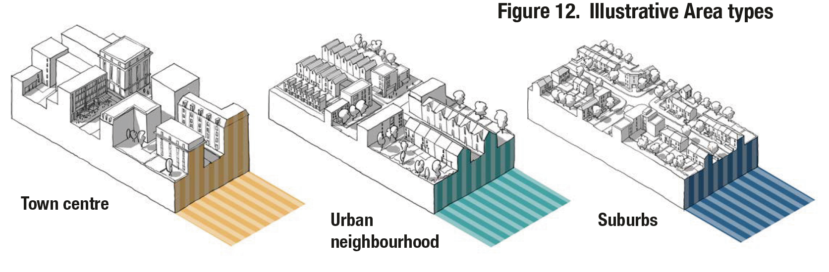
Figure 12. Illustrative Area types
Movement
50. Well-designed places should be accessible and easy to move around. This can be achieved through a connected network of streets, good public transport, the promotion of walking and cycling and well-considered parking and servicing. Detailed information is provided in Guidance Note Code Content: Movement. The following might require area type-specific guidance:
i New streets: All new streets should be safe and overlooked and correspond to their role in the street hierarchy and area type - e.g. a primary street in an urban centre will have a different character to one in a village. See M.1.iii - Street Hierarchy.
ii New junctions: Guides might specify traffic signalled junctions on high streets and less formal, unmarked junctions on local streets. See M.2.ii - Junctions and Crossings.
iii Car parking: Standards for all uses will be set in the local plan, but the ways in which they are accommodated will vary. See Fig 13 and 14 and M.3.i - Car parking.
iv Cycle parking: Standards will be set in the local plan and specified in codes according to context. e.g. public cycle parking on a high street or private cycle storage in a dwelling. See M.3.ii - Cycle parking.
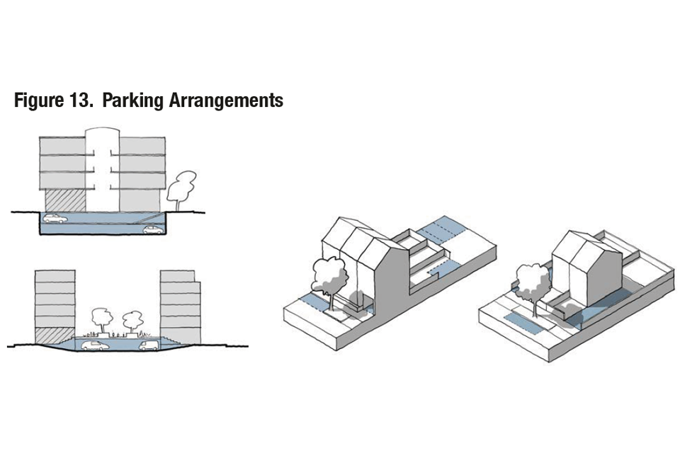
Figure 13. Parking Arrangements
Town centre: New provision should be at basement, semi-basement or decked. New surface parking might be prohibited where there is a clear and compelling justification.
Urban neighbourhood: Likely to be on-street (for visitors), within the building (townhouse), or to the rear in gardens or parking courts.
Suburbs: Likely to be in-curtilage, at the front (with suitable landscape features) or to the side of the property, so cars don’t dominate the street. Visitor parking is likely to be on-street.
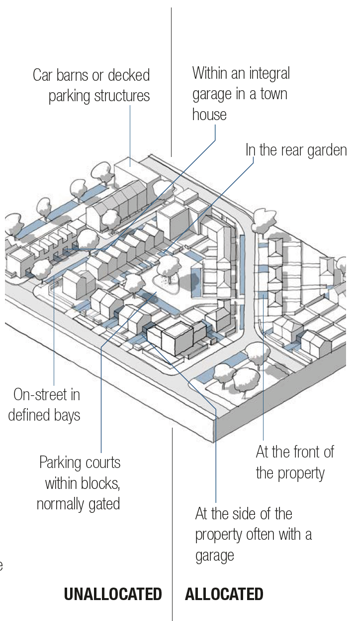
Figure 14. Residential Parking Options
[Alt text: This is an annotated 3D line drawing of a residential neighbourhood, annotated with different residential parking options. They are split into allocated and unallocated solutions. The unallocated solutions include:
- car barns or decked parking structures
- on-street in defined bays
- Parking courts within blocks, normally gated
The allocated parking solutions include:
- Within an integrated garage in a town house
- In the rear garden
- At the front of the property
- At the side of the property, often within a garage ]
Nature
51. Nature and green spaces should be woven into the fabric of our villages, towns and cities. This provides benefits in terms of health and wellbeing, biodiversity, climate and flood mitigation and can connect nature to wider surroundings. Detailed information is provided in Guidance Note Code Content: Nature. Most of the guidance on nature will be general. The following might require area type-specific guidance:
i Open spaces: Open space standards may vary, with less open space in smaller, accessible pockets required in town centres and more generous provision in suburbs. Key principles for integrating green space can be adapted for different contexts. See Fig 15 and N.1.iii - Open Space Design.
ii Sustainable drainage systems (SuDS): In urban areas, these may be integrated into the built environment, while suburbs could make use of natural/landscape features. See Fig 16 and N.2.ii - Sustainable Drainage.
iii Green infrastructure: Urban area types might include requirements for planned open spaces, SuDS and other green infrastructure such as green roofs and walls, lower density areas for more natural green spaces and habitats and utilise urban greening factor tools. See N.3.ii - Planning for Biodiversity.
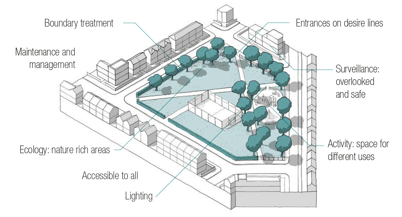
Figure 15. Open Space Design: Key principles of how green space can be integrated to improve the environment and liveability, and which can be tailored to different contexts.
[Alt text: This is an annotated 3D line drawing of an open green space surrounded by buildings. The space has the feel of a neighbourhood park with trees and a playground area. The annotations indicate key elements of good open space design and are as follows:
- Boundary treatment
- Entrances on desire lines
- Surveillance: overlooked and safe
- Activity: space for different uses
- Lighting
- Accessible to all
- Ecology: nature rich areas
- Maintenance and management ]
Figure 16. SuDS toolkit: A variety of tools that can boost sustainable drainage in different contexts.
[Alt text: This is an annotated 3D line drawing of a residential block surrounded by a variety of green and blue spaces. The annotations highlight a variety of sustainable drainage solutions and include:
- Rain capture (water butts)
- Permeable surfacing
- Basins and ponds
- Reedbeds and wetlands
- Connection of nature to wider surroundings
- Rain gardens
- Retention tanks
- Swales
- Street trees
- Green roofs
- Soakaways and filter drains ]
Built form
52. Built form refers to the three-dimensional arrangement of buildings, blocks, streets and spaces. This will form the core of the design code and the settings for each element of built form will vary considerably by area type. Detailed information is provided in Guidance note code content: Built form.
i Density: Codes should define density ranges, which are likely to be higher for town and local centres and lower in suburbs (illustrative example below) Mixed use schemes can be calculated on a pro-rata basis. See B.1.i Density.
Town centres: >200d/ha
Urban Neighbourhoods: 60-120d/ha
Suburbs: 30-50 d/ha
ii Plot ratio: Calculated by dividing the gross floor area of the building by the area of the plot, plot ratios along with site coverage should be used alongside good urban design principles to regulate the density of mixed-use and non-residential uses (example below) See B.1.i Density.
Town centres: >2
Urban neighbourhoods: >1
Suburbs: <0.5
iii Whether buildings join: How buildings relate to neighbouring buildings has an important impact on urban form. Likely variation in guidance by area type is shown in Fig 17. See B.1.ii Whether Building Join.
iv Grain: The pattern of plots in an urban block/area. New development should, where possible, be sympathetic to the existing grain. The grain is likely to be finer (smaller plot size) in town/local centres and coarser (larger plot sizes) in suburbs. See B.1.iii Building Types and Forms.
v Public/private: New development should create a clear separation between the public fronts of buildings and the private rears within the centre of development blocks. This is normally achieved using blocks. Likely variation by area type is shown in Fig 18. See B.2.i Blocks.
vi Edges of development Codes should demonstrate how the edges of plots are treated and how this relates to the landscape and wider context.
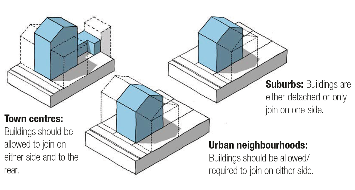
Figure 17. Whether buildings join.
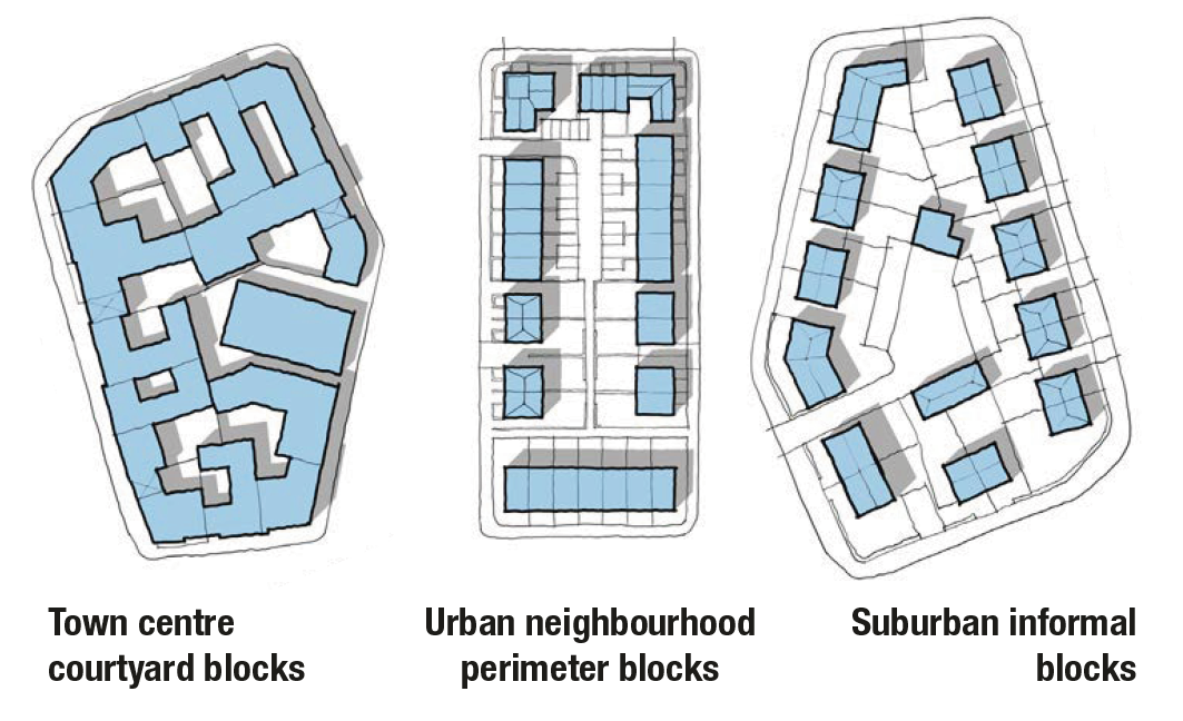
Figure 18. Typical Block Types.
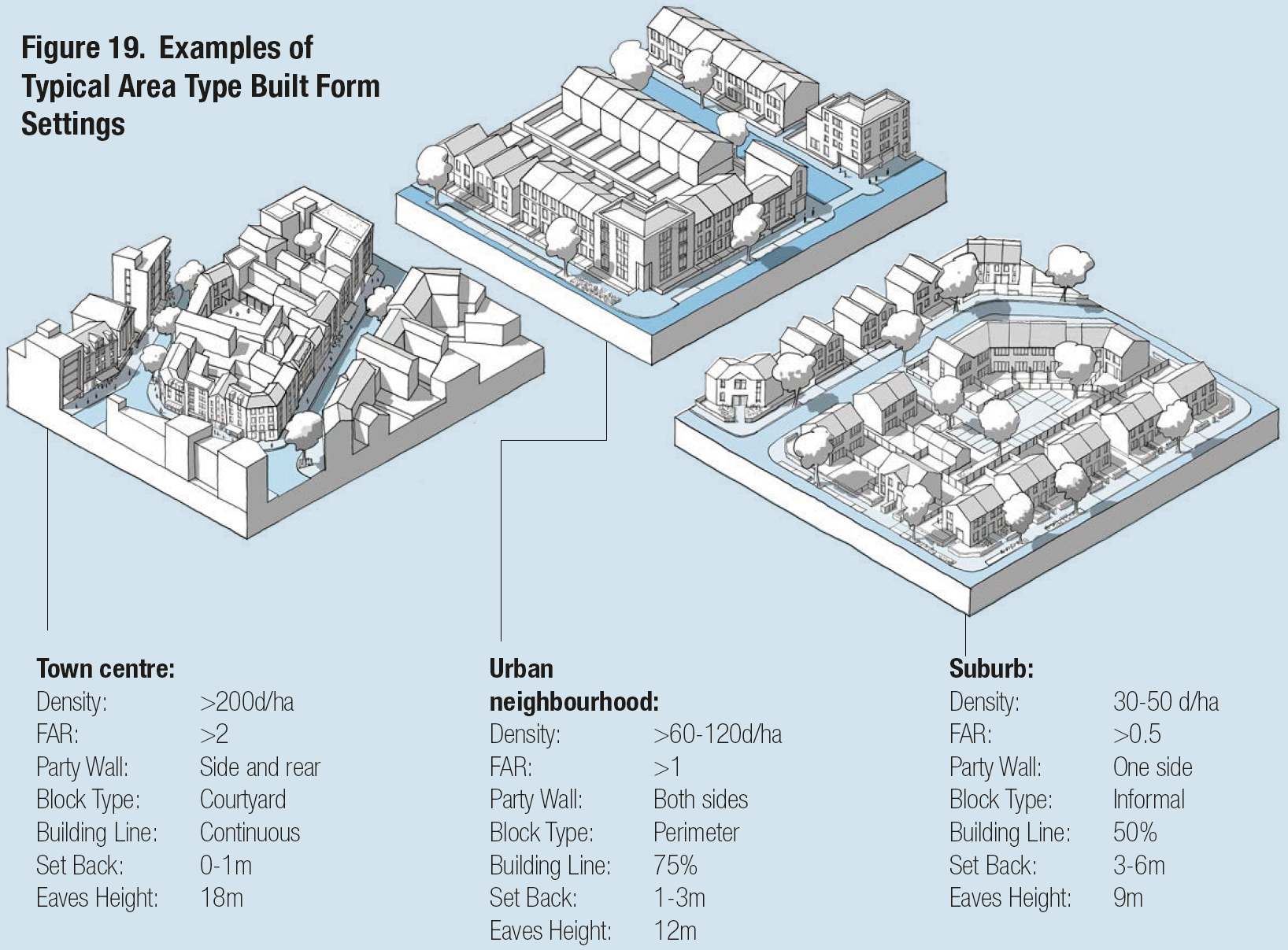
Figure 19. Examples of Typical Area Type Built Form Settings.
[Alt text: Series of three 3D line drawings illustrating how different built form settings can be combined to create area types with distinct forms and characters. The images show a higher-density town centre environment, a medium density urban neighbourhood and a lower density suburb. The following captions provide a list of settings for each example.]
vii Building line: The building line s created by the primary front face of buildings along a street and is a key element of design codes. New development should follow the established building line where it exists. Where there is no building line (for example on the periphery of a town centre or a development site), codes should set one. Coding for building lines can include:
- Variation: The extent to which buildings can be set forward or back from the line.
- Projections: Allowance for elements such as balconies.
- Compliance: The percentage of the building line that should be occupied by development.
- Set-back: The distance that buildings are set-back from the pavement.
Figure 20 shows how building line guidance might change by area type.
See B.2.ii. Building line.
viii Heights: The height of buildings will be a key element of design codes. This is regulated through eaves heights, total heights and exceptions. Figure 21 shows how heights might vary by area type. See B.2.iii Height.
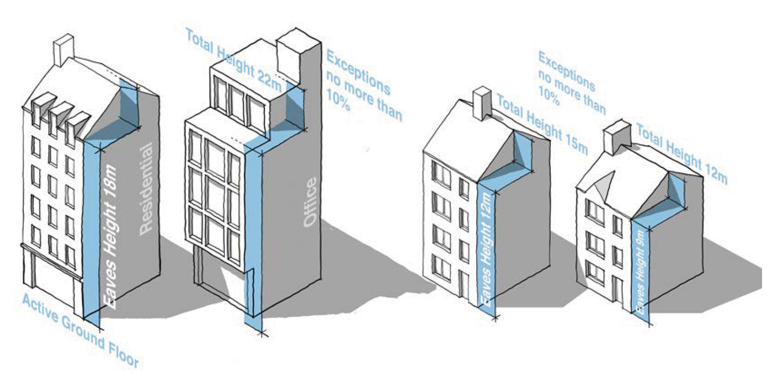
Figure 21. Heights.
Town centre heights: An example showing an eaves height of 18 meters and a maximum height of 23 meters, allowing 5 storeys of housing or 4 storeys of offices over active ground floor uses.
Urban neighbourhood and suburban heights: An example showing an eaves height of 12 meters and 9 meters with maximum height of 3 meters above this, allowing for 4 or 3 storeys of housing.
ix Tall buildings: In many areas codes will need to make provision for taller buildings. Some city area types may include limited restrictions on height. However, in most area types codes can either indicate zones where taller buildings can be considered or indicate the circumstances where exceptions to the height coding might be considered See B.2.iii Height Para 118-119.
53. The identity of an area comes not just from its built form and public spaces but also from the design of its buildings. This is not about architectural style, but about key principles of building design. All new buildings should take into account the architectural character and materials of the surrounding area. In local design codes guidance on identity will vary considerably from area to area, informed by the worksheet at the appendix of the guidance notes, and may include guidance on the following components. Detailed information is provided in Guidance Note Code Content: Identity, in particular Section I.2.i Building Design Principles.
i The base of the building: The ground floor may be treated differently to the upper floors to create a relationship with the street. It may use different materials and include active uses, especially in the context of a town/local centre.
ii Thresholds: Entrances should be emphasised in the architectural treatment of façades. This can include porches, recessed doors and other entrance features.
iii Boundaries: The treatment of boundaries has a significant role to play in creating character. Figure 23 shows how guidance on boundaries might change according to area type.
iv Roofscape: Variation in eaves height and roof forms will vary based on the character of the local area. Historic town centres, villages and suburbs tend to have a variety of roof types whereas a Georgian inner neighbourhood, for example is typically uniform.
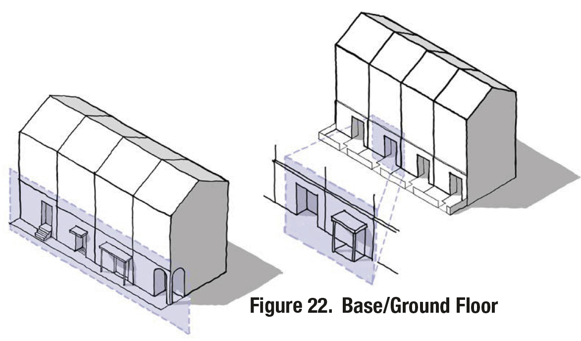
Figure 22. Base/Ground Floor.
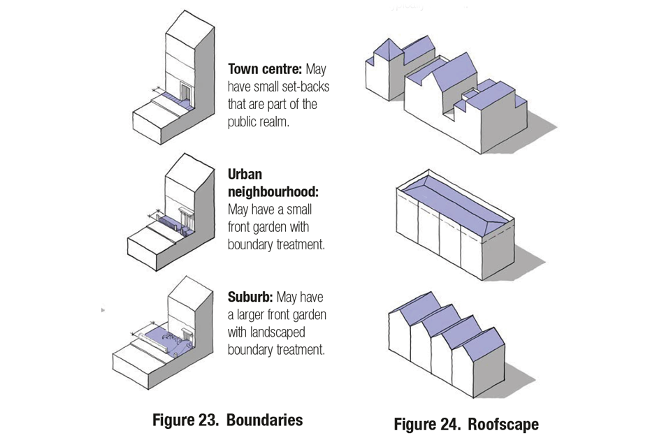
Figure 23. Boundaries. Figure 24. Roofscape.
[Alt text: Fig 23 shows a series of three 3D line drawings illustrating the ways that boundary treatments might vary by area type, using a single building as an example. The following captions explain the likely variations:
- Town centre: May have small set-backs that are part of the public realm.
- Urban neighbourhood: May have a small front garden with boundary treatment.
- Suburb: May have a larger front garden with landscaped boundary treatment.
Fig 24 shows a series of 3 3D illustrative line drawings showing how roofscapes might vary by area type. The first shows a varied roofscape, the second a more uniform flat roofscape and the third a uniform pitched roofscape with gables facing the street. ]
v Windows: Guidance may be provided on the design of windows based on the character of the area. The proportion of glazing may vary with city centres allowing fully glazed façades but elsewhere the glazing ratio might be limited to 35%. Guidance can also direct the orientation of the windows and the depth of reveals.
vi Variation in frontages: Guidance may be provided on the level of articulation such as set-backs, porches, balconies and bays, especially if the character of such features are particular to the existing area. Fig 26 shows how frontage variation can create different characters.
vii Detailing: Guidance may be provided on the use of colour, quality of materials and detailing, drawn from the surrounding context, e.g. an area might be characterised by the use of a particular type of brick. A degree of complexity will ensure that buildings are attractive from a distance and close-up. Fig 27 shows how depth and interest can be created with window details.
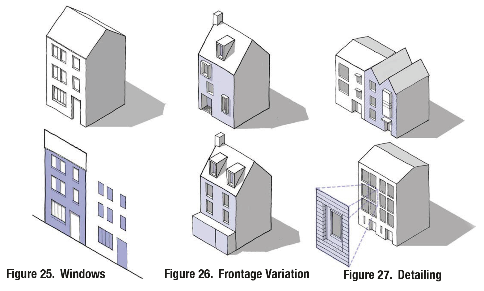
Figure 25. Windows. Figure 26. Frontage Variation. Figure 27. Detailing.
[Alt text: Fig 25 is a 3D line drawing of a house with glazed windows and a door, accompanied below by a diagram showing the resulting ratio of glazed surfaces to facades.
Fig 26 is a 3D line drawing of two houses, illustrating how changes to the variation in frontages can change the character of two buildings with broadly the same underlying form. One shows windows placed in an irregular pattern across the facade, while the other is more ordered and traditional.
Fig 27 shows a 3D line drawing of two buildings, illustrating how depth and interest can be created with window details. The lower image highlights how detailing can create interest when viewed both from a distance and close up. ]
Tall building design principles: Tall buildings may be permitted in certain area types which will require guidance on their design. Key principles are set out below. See I.2.i Para 49 for more detail.
Top: Consider the impact on the skyline. Services need to be concealed, and both the street views and the long views need to be considered.
Form: Should be well-proportioned in terms of slenderness when viewed from all frontages.
Materials: The use of materials to be consistent and simple.
Base: Consider following the building line at street level, which may require a base to the building that is scaled to the surrounding buildings.
Public realm: Public spaces around the base to be generous, well designed and contribute positively to the local context.
Entrance: The entrance needs to clearly marked.
Micro-climate: Needs to be considered in terms of overshadowing and wind. It may be necessary to protect the surrounding public realm from down draughts.
Active frontage: If required by the design code the ground floor of the tall building needs to include active frontages.
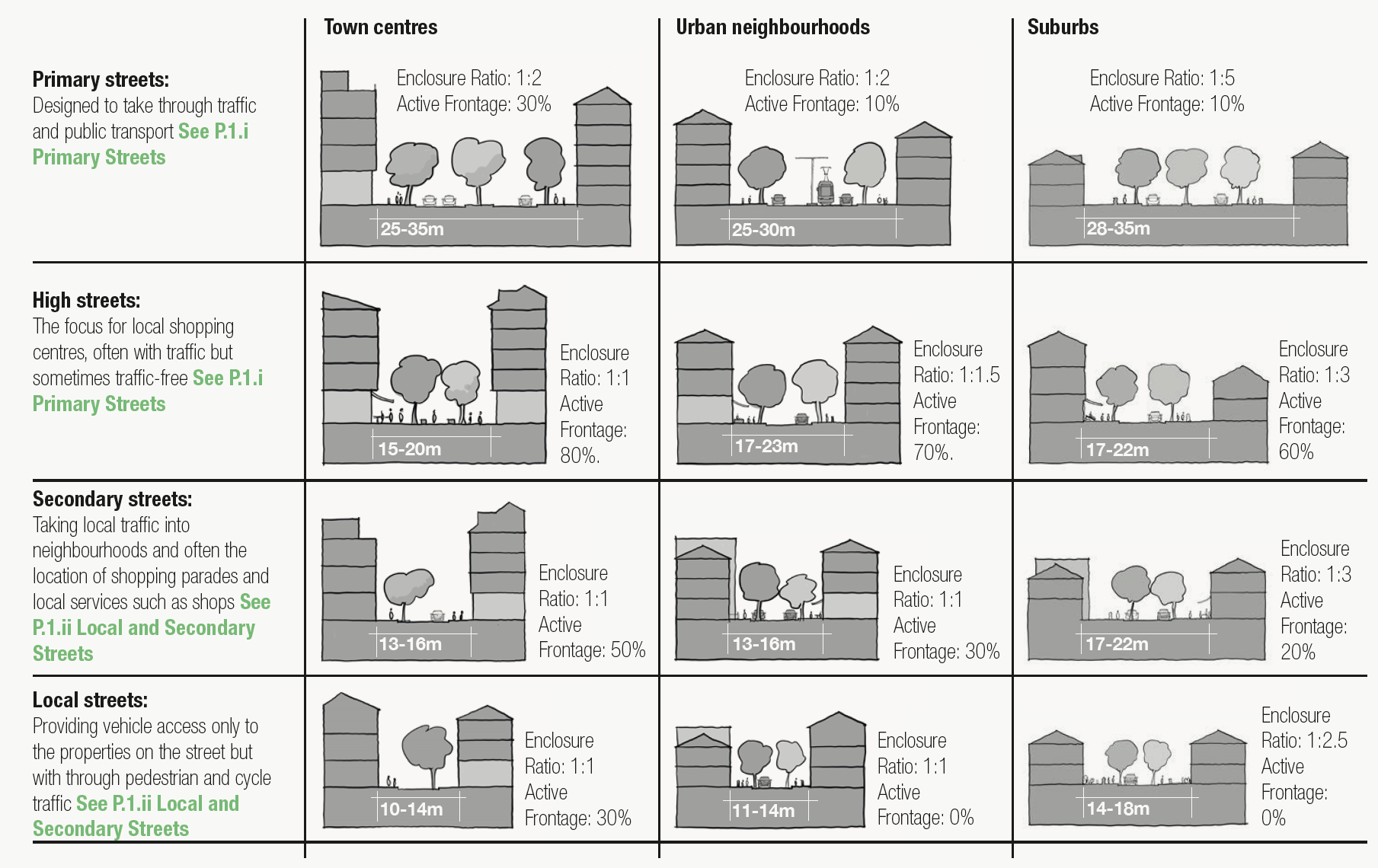
Figure 28. Street Matrix.
[Alt text: Fig 28 is laid out as a table, showing how different levels of the street hierarchy would vary by area type. The types of streets are listed down the left hand side, and the area types are listed across the top. In each instance an image showing an example street section is included, along with examples settings. The reader will read each street type in order, going through the settings for each area type before moving down the street hierarchy. ]
54. The quality of public space is partly about the way it is designed and partly about the way it is enclosed by well-proportioned buildings. Detailed information is provided in Guidance Note Code Content: Public Space. Streets are a component of public space which will vary considerably by area type. Section P.1 details different types of street, showing how urban form can be coordinated with the guidance in Manual for Streets.
i Streets: New development should contribute to the character of the street on which it is located. This character will be different depending where the street sits in the street hierarchy and the context in which it is located. Figure 28 illustrates how the characteristics of a street might vary by area type and position on the street hierarchy. A similar diagram could form part of design code guidance at local level. See P.1 Streets.
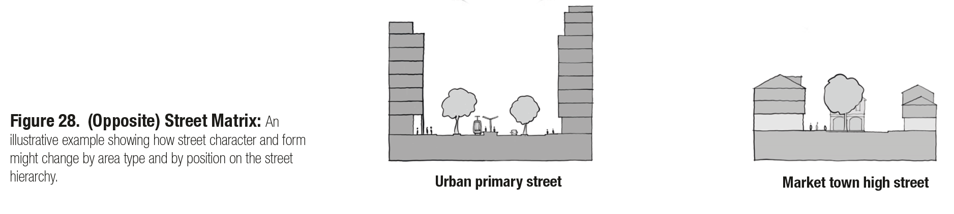
Figure 28. Street Matrix: An illustrative example showing how street character and form might change by area type and by position on the street hierarchy.
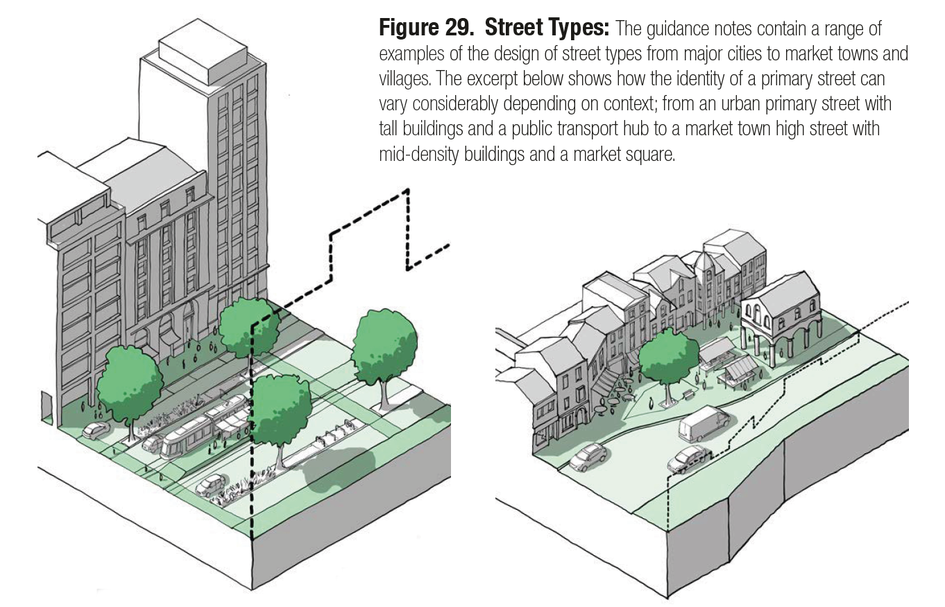
Figure 29. Street Types: The guidance notes contain a range of examples of the design of street types from major cities to market towns and villages. The excerpt below shows how the identity of a primary street can vary considerably depending on context; from an urban primary street with tall buildings and a public transport hub to a market town high street with mid-density buildings and a market square.
Use
55. Sustainable places include a mix of uses that support everyday activities including space to live work and play. Detailed information is provided in Guidance note code content: Use. The following components are likely to vary by area type.
i Intensification: Making more efficient use of land. In urban areas this might mean infill development or development of airspace. In suburban areas it might mean garden development. See U.1.i Efficient use of land.
ii Mix: A mix of uses will likely be a requirement in centres, will be encouraged in urban neighbourhoods and may be permitted but not required in suburbs. See U.1.ii Mix.
iii Active frontage: Ground floor uses that create interest and activity. Requirements for such uses will likely be higher in town/local centres than suburbs and will also vary by street type. See U.1.iii Active Frontage.
iv Housing: The mix of housing tenures and types will vary with apartments being the norm in town centres and a greater mix being required in urban neighbourhoods and suburbs. See U.2. Housing Mix.
v Schools: Guidance on schools will likely be based on similar principles of integrating with the existing built form, but urban areas are likely to require more dense solutions. See U.3.i Schools.
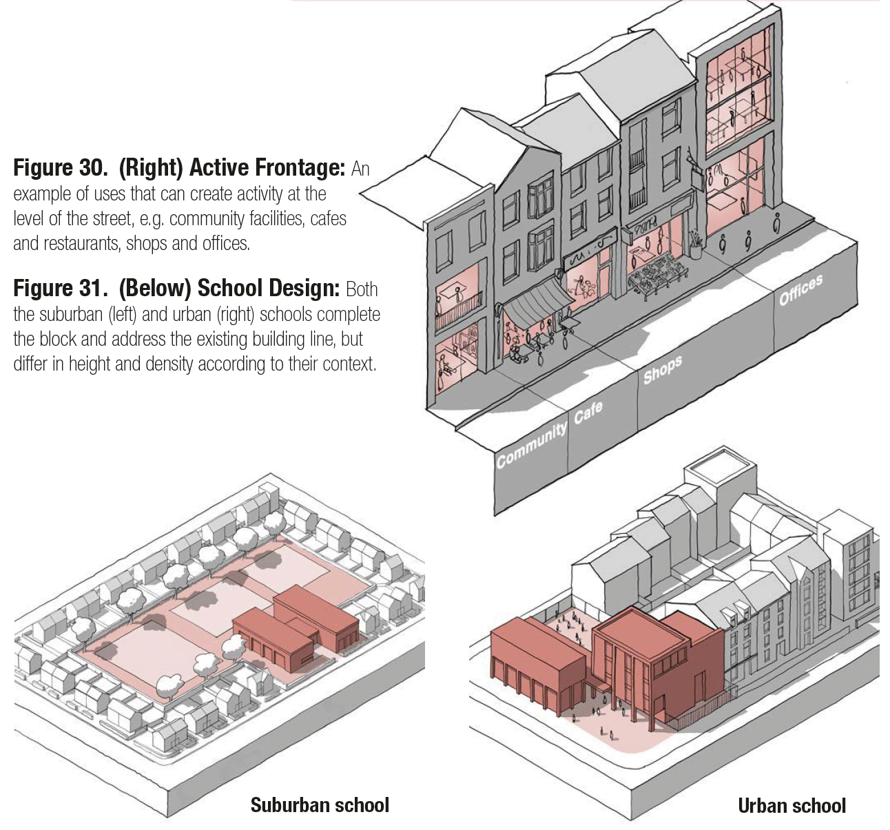
Figure 30. (Right) Active Frontage: An example of uses that can create activity at the level of the street, e.g. community facilities, cafes and restaurants, shops and offices. Figure 31. (Below) School Design: Both the suburban (left) and urban (right) schools complete the block and address the existing building line, but differ in height and density according to their context.
[Alt text: Fig 30 is a 3D line drawing of a section of a street, illustrating a number of different types and configurations of active frontage, including a community use, cafe, shops and offices.
Fig 31 contains a pair of 3D line drawings showing how a school can be integrated into a block in different contexts. The first image shows a suburban school and the second shows a higher density urban school. ]
Homes and buildings
56. Well-designed homes and buildings are functional, accessible and sustainable. Detailed information is provided in Guidance Note Code Content: Homes and Buildings. The majority of issues are unlikely to vary by area type, the elements that may vary are detailed here.
i Lighting, aspect and privacy: In more urban areas there may be a need for more lighting and shorter privacy distances might be acceptable, while in suburban areas lighting might be more minimal and privacy distance might be greater. See H.2.i Lighting Aspect and Privacy.
ii Gardens and balconies: Codes might specify minimum sizes for gardens and balconies to improve well-being and amenity. In more urban areas this might be smaller, while in suburban areas larger garden spaces might be specified. See H.2.iii Gardens and Balconies.
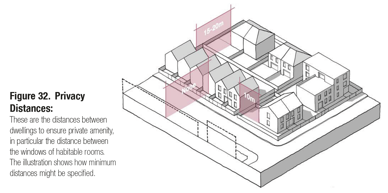
Figure 32. Privacy Distances: These are the distances between dwellings to ensure private amenity, in particular the distance between the windows of habitable rooms. The illustration shows how minimum distances might be specified.
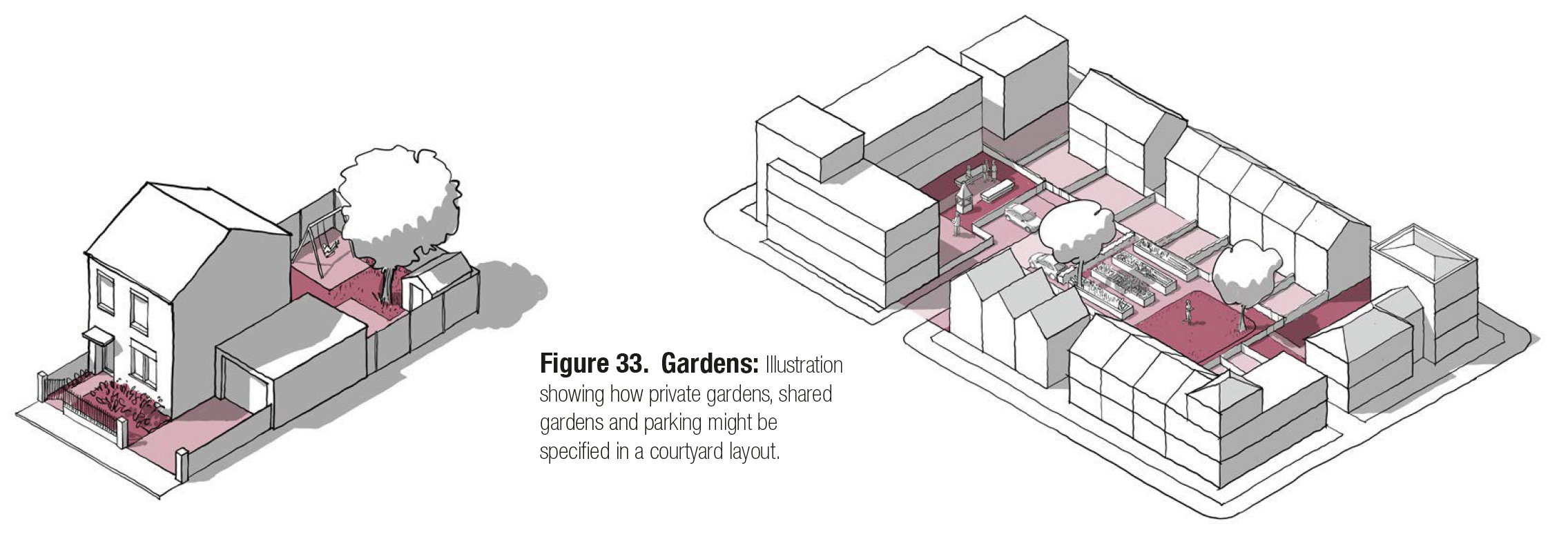
Figure 33. Gardens: Illustration showing how private gardens, shared gardens and parking might be specified in a courtyard layout.
3.B Code wide guidance
57. In addition to the guidance in step 3a the following guidance relates to all development within the area covered by the design code or guide regardless of area type. All of this must be referenced back to a policy within the local plan.
Context
58. An understanding of the context, history and character of an area must influence the siting and design of new development as set out in Guidance Notes Code Content: Context. This should be informed by:
i Character studies: All schemes should consider their context and schemes over a specified size should be accompanied by a context study. See C.1 Character Studies.
ii Historic assets: Schemes should respect the historic assets of the site and its surroundings, making use of existing structures where possible. See C.2 Cultural Heritage.
Figure 34. Context Study Extract. See C.1.ii for example of context study content.
Movement
59. A connected network of streets, good public transport and the promotion of walking and cycling are key principles, as set out in Guidance Notes Code Content: Movement and summarised below:
i Connected places: All schemes should contribute to the creation of an integrated, walkable and safe street network:
- New streets should link at either end to other streets where possible. See M.1.i The Street Network.
- Cul-de-sacs are acceptable only as tertiary streets.
- All new streets should be allocated to a level of the street hierarchy and follow the appropriate guidance. See M.1.iii Street Hierarchy.
- All development should be within easy reach of public transport. See M.1.ii Public Transport.
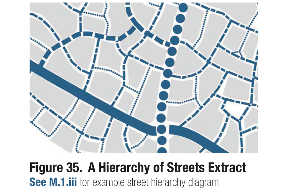
Figure 35. A Hierarchy of Streets Extract. See M.1.iii. for example street hierarchy diagram.
ii Active travel: New development should contribute to the creation of well-lit, direct and overlooked pedestrian and cycle routes. See M.2 Active Travel.
- Low traffic neighbourhoods may be appropriate but only where supported by the local community.
- All streets should be accessible to all members of the community.
- All new streets other than local and tertiary streets should include separate cycle lanes.
- Junctions should be designed in accordance with Manual for Streets to be safe, convenient and attractive for all users. See M.2.ii Junctions and Crossings.
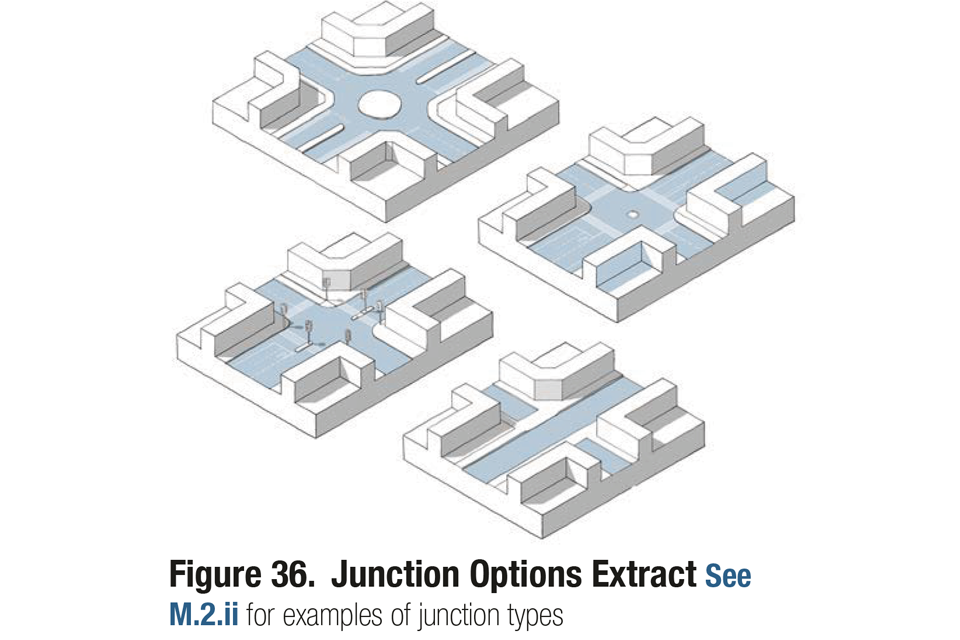
Figure 36. Junction Options Extract. See M.2.ii. for examples of junction types.
iii Car parking: The arrangements for car parking can have a major impact on the quality of place. They should aim to minimise the impact of the car and solutions will vary depending on context, as set out in Section 3A P17. See M.3.i Car Parking.
iv Cycle parking: Provision of the storage of cycles for residents, workers and visitors needs to be integrated into all development. See M.3.ii Cycle Parking.
v Servicing: New development should integrate the requirements of utility providers, refuse collection and emergency access without compromising the quality of place by obstruction of movement or visual intrusion. See M.3.iii Services and Utilities.
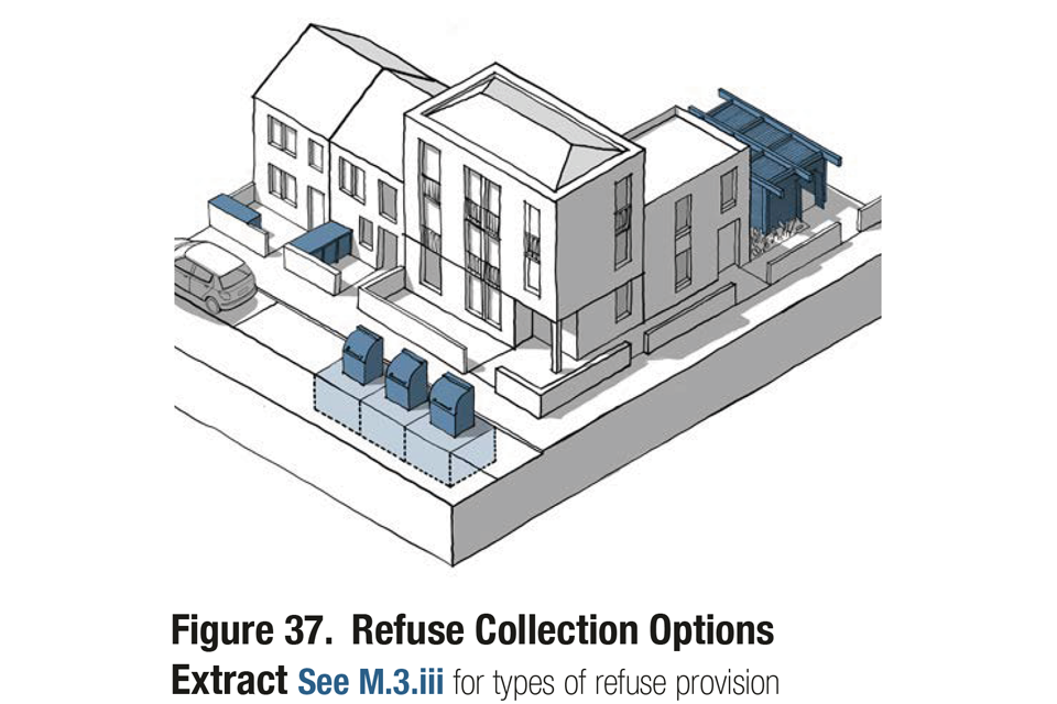
Figure 37. Refuse Collection Options Extract. See M.3.iii for types of refuse provision.
Nature
60. All development should enhance the natural as well as the built environment as set out in Guidance notes code content: Nature. Most of the guidance will apply to all area types and is summarised below:
i Green infrastructure: New development should contribute towards the creation of a network of green spaces and facilitate access to natural green space where possible. Summary below. See N.1.i Network of Spaces.
- The requirement for new green space should be based on the government’s open space and recreation guidance, that is:
- All housing schemes over 15 dwellings should include a Local Area of Play (LAP).
- All schemes over 200 dwellings should include a Local Equipped Area of Play (LEAP) within 400 meters.
- All schemes over 500 dwellings should include a Neighbourhood Equipped Area of Play (NEAP) within 1,000 meters.
ii Water and drainage: Schemes should make the most of waterside locations and address sustainable drainage and flooding, schemes should:
- Make the most of their waterside location, facing onto the water and retaining public access to the water’s edge. See N.2.i Working with Water.
- Integrate sustainable drainage systems into the early stages of design to reduce flood risk and improve water quality, biodiversity and amenity. See N.2.ii Sustainable Drainage.
- Take account of flood risk and the need for measures to address flood risk. See N.2.iii Flood Risk
iii Biodiversity: All schemes will be expected to follow national policy by achieving a minimum 10% net gain in biodiversity.
- Schemes should incorporate biodiversity design principles, e.g. creating and enhancing habitats. See N.3 Biodiversity.
- All new streets should include street trees to improve streets’ popularity and walkability, reduce air pollution and mitigate noise. See N.3.iii Street Trees.
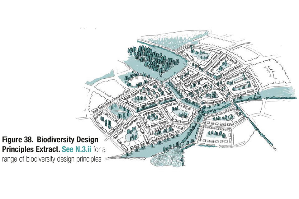
Figure 38. Biodiversity Design Principles Extract. See N.3.ii for a range of biodiversity design principles.
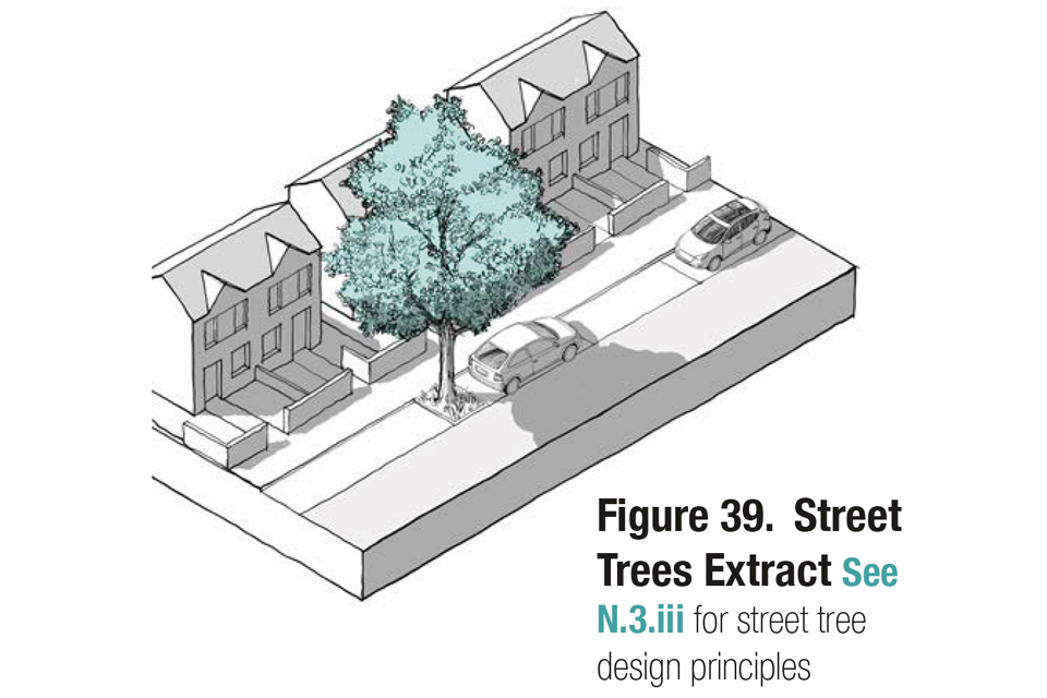
Figure 39. Street Trees Extract. See N.3.iii for street tree design principles.
Built form
61. Most of this guidance will change based on context and area type as set out in Guidance notes code content: Built form. The following will apply to all development:
i Public and private: There should be a clear separation between public and private space, which will generally be achieved through development blocks. New development should repair the existing block structure, where possible. See B.2.i Blocks.
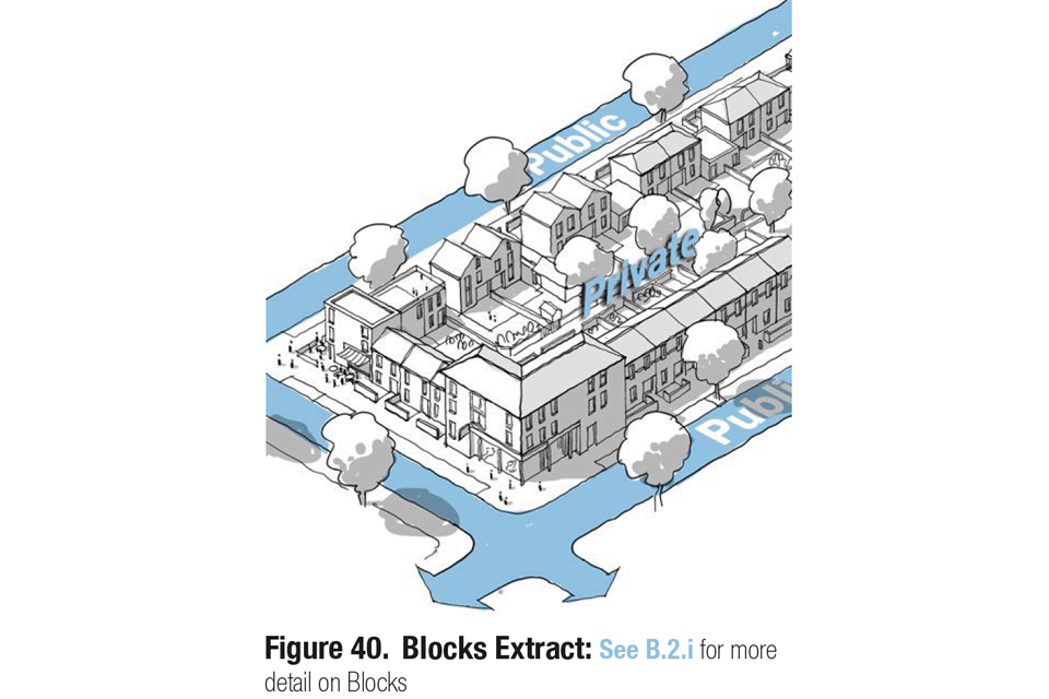
Figure 40. Blocks Extract: See B.2.i for more detail on Blocks.
Identity
62. All schemes should be designed to respect and enhance the existing character of the surrounding area. The principles set out in Guidance notes code content: Identity will apply to most development (summary below)
i Sense of place: All schemes should be designed to enhance local character and legibility by:
- Making use of local materials and detailing. Incorporating legibility and wayfinding strategies Being guided by a strong masterplan.
See I.1 A sense of place.
ii The identity of buildings: All buildings should take account of the principles set out in I.2 The Identity of Buildings.
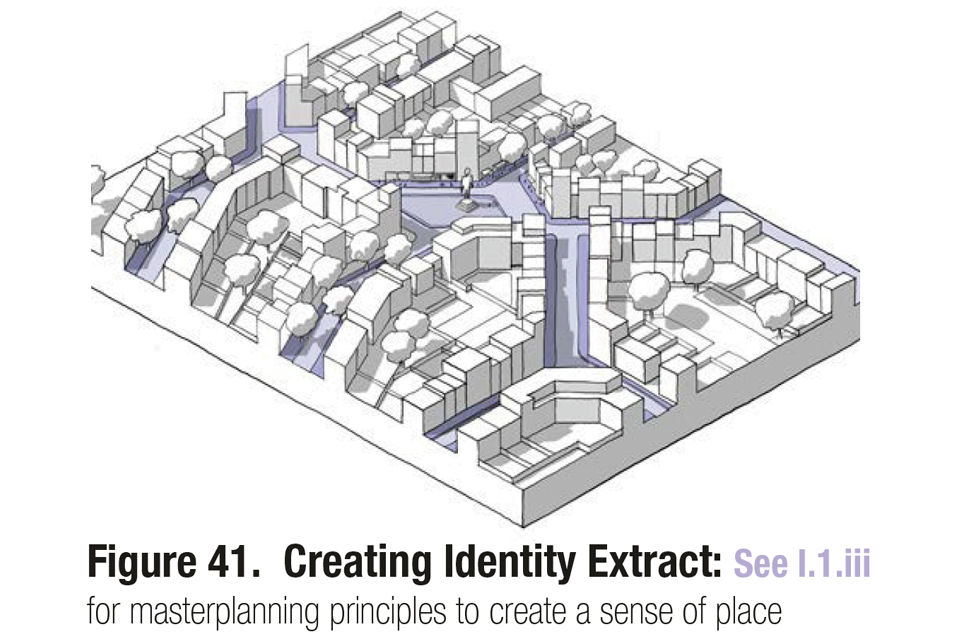
Figure 41. Creating Identity Extract: See I.1.iii for masterplanning principles to create a sense of place.
Public Space
63. Details about how guidance might change by context and area type is set out in Guidance notes code content: Public space. The key principles below will apply more broadly:
i Streets: The design of streets should be based on their place in the street hierarchy and their context. See P.1 Streets.
ii Social interaction: Public spaces should encourage activity and social interaction. See P.2.i Meeting Places.
iii Multi-functional streets: Streets should aim to accommodate a range of travel modes. See P.2.ii Multi-functional Streets.
iv Safety and security: All schemes should aim to create a safe and secure environment and provide a sense of security for all users. Where development is for or has potential for a significant concentration of people, schemes should also consider appropriate and proportionate security measures. See P.3.i Secured by Design & P.3.ii Counter terrorism.
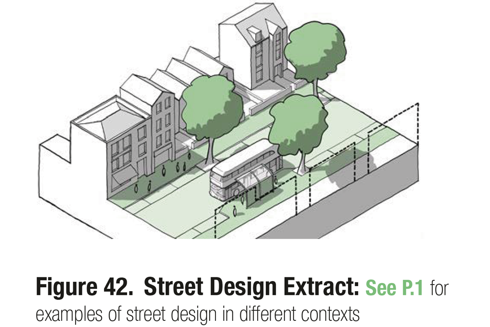
Figure 42. Street Design Extract: See P.1 for examples of street design in different contexts.
Use
64. Much of the guidance on use will vary by context or area type as set out in Guidance Notes Code Content: Use. The following guidance could apply more generally:
i Intensification: Making more efficient use of land is encouraged taking into account context and constraints. See U.1.i Efficient use of land.
ii Variety of activity: A mix of different uses is encouraged, to create variety and activity. See U.1.ii Mix.
iii Housing mix: All schemes should include a mix of tenures and house-types including specialist housing, live/work and custom-build units where possible. See U.2 Housing Mix.
iv Schools: Should be designed as part of the neighbourhood, integrating into the existing building line and block pattern. See U.3.i Schools.
v Community facilities: Larger schemes should make provision for new community facilities and related amenity space. See U.3.ii Community facilities.
vi Local services: All new housing should be within easy access of a range of local services including shops and health facilities. See U.3.iii Local services.
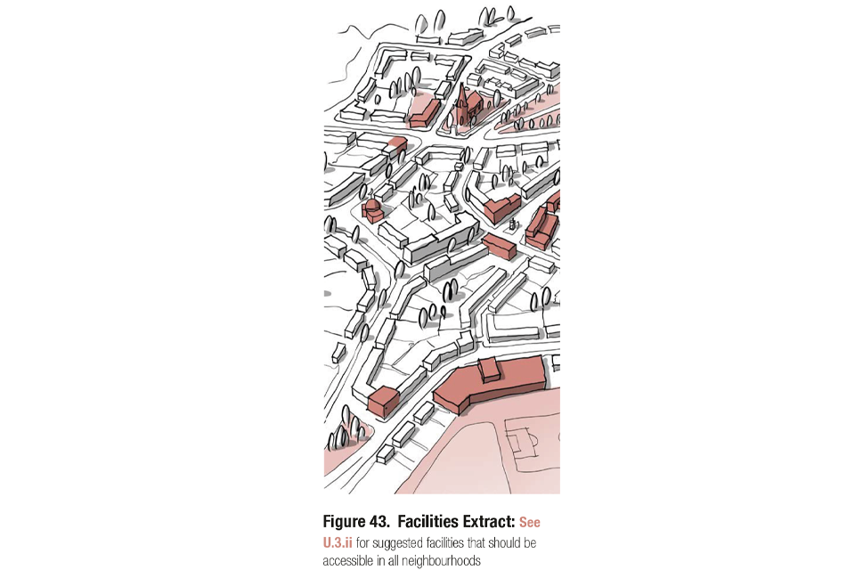
Figure 43. Facilities Extract: See U.3.ii for suggested facilities that should be accessible in all neighbourhoods.
Homes and buildings
65. Standards relating to the design of homes and buildings are important and can be included in design policies in local plans or design codes that are adopted in local plans, with the detailed design of inter-related requirements resolved at project level. The following may be included (See Guidance notes code content: Homes and buildings for more information):
i Space standards: Nationally described space standards may be included in codes. See H.1.i. Space Standards.
ii Accessibility: Codes can identify accessibility standards as set out in Part M of the Building Regulations. See H.1.ii Accessibility.
iii Lighting, aspect and privacy: All habitable rooms should receive adequate levels of daylight. Single aspect north-facing dwellings should be avoided. See H.2.i Lighting, aspect and privacy.
iv Secured by design relating to the home: Codes may incorporate guidance on the security of the home in accordance with Part Q of the Building Regulations. See H.2.ii Security.
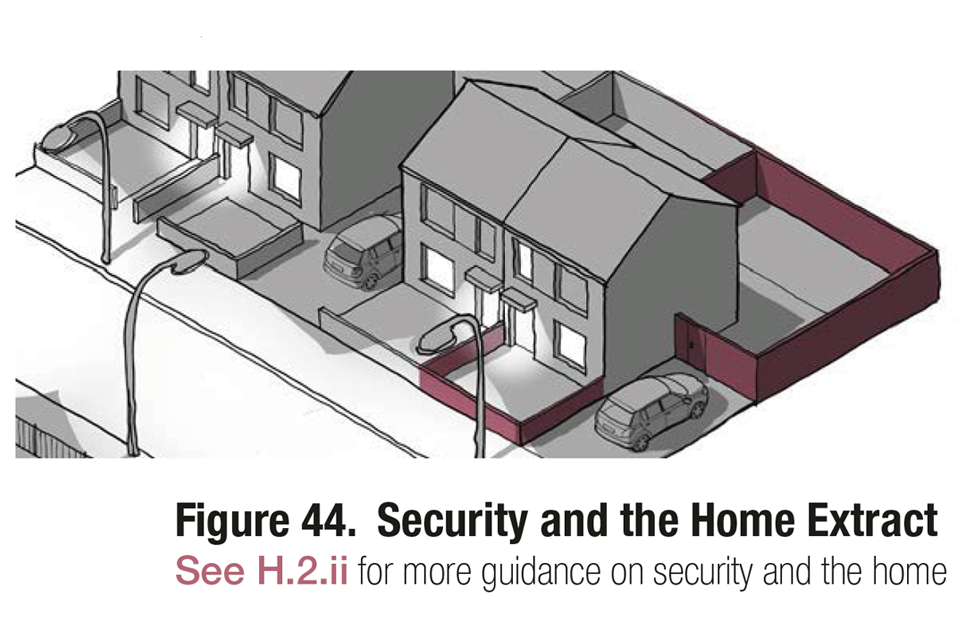
Figure 44. Security and the Home Extract. See H.2.ii for more guidance on security and the home.
Resources
66. Standards relating to sustainability are important and can be incorporated into codes or covered in other policy, and the detail design of inter-related requirements resolved at project level. They might include the following (See Guidance Notes Code Content: Resources):
i Energy efficiency standards: Local authorities can set policies in local plans or design codes that are adopted in local plans for higher energy efficiency standards for their area or specific development sites. See R.1.ii Energy Efficiency.
ii Passive energy design: Development should be designed to optimise passive solar gain without risking overheating. Orientation should be optimised in as far as it does not contradict other approaches in this guide. See R.1.ii Energy Efficiency.
iii Local low carbon, low energy networks: May be encouraged by codes. See R.1.iii Neighbourhood Energy Issues.
iv Environmental standards: Codes may set standards for new development to meet relating to:
- Embodied energy/carbon.
- Whole life-cycle carbon.
- BREEAM Ratings and other best practice guidance.
- Modern Methods of Construction.
- Water usage.
v Onsite renewable sources: The use of renewable energy sources should be maximised and a ‘fabric first’ approach where appropriate. See R.2 Sustainable construction.
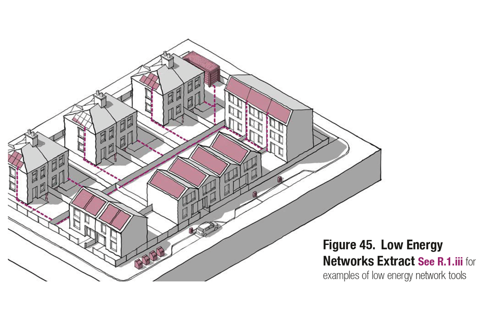
Figure 45. Low Energy Networks Extract. See R.1.iii for examples of low energy network tools.
Lifespan
67. Lifespan relates to way schemes are managed and the way that residents are involved in design and management. These issues can be included in design codes and may include the following (See Guidance notes code content: Lifespan for more information):
i Management plans: These set out the approach to adoption and management, including the potential for community management. They may be a requirement for schemes over a certain size. See L.1.i Management plan.
ii Community participation: Codes may require that consultation take place on all schemes prior to the submission of a planning application. See L.1.ii Participation in Design.
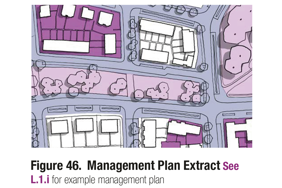
Figure 46. Management Plan Extract. See L.1.i for example management plan.
Glossary
Area type
Parts of the local area that share common features and characteristics. For example, a suburban area type might bring together a number of different housing estates with common densities, heights, building line, party wall condition etc.)under the umbrella term “outer suburbs”.
Common rules and parameters can then be applied to the “outer suburbs” area type in the design code.
Example area types are provided in the National Model Design Code, but in practice area types should be defined locally.
Area type matrix
A table detailing the elements of the design code that are likely to differ between area types.
Area type work sheet
A set of prompts and sections to be completed, detailing the key elements and features that should be considered when undertaking a character study. This is not an exhaustive list and should be adapted locally.
Character study
A process of analysis at area type level to determine the elements and features that contribute to the unique character of a place. This process can be used to determine existing area types, using the area type work sheet.
Coding plan
A plan at local authority level showing the local areas to which a code will apply. The coding plan can show:
- Existing built-up areas
- Landscape designated areas
- Heritage areas
- Protected open space
- Special policy areas
- Development areas
Context study
A mapping exercise detailing spatial information about the area surrounding a site. A suggested list of information that could be included is provided within the context section of Guidance note: code content.
Design code
A set of illustrated design requirements that provide specific, detailed parameters for the physical development of a site or area. The graphic and written components of the code should build upon a design vision, such as a masterplan or other design and development framework for a site or area.
Design guide
A document providing guidance on how development can be carried out in accordance with good design practice, often produced by a local authority.
Design vision
A clear articulation of what an area should be like in the future, developed with the local community. Local planning authorities may wish to create a vision statement setting out specific aims of the design code.
Development area
Parts of the local area where radical, rather than incremental change is planned. These might include regeneration areas where significant change is expected to the existing urban form, urban extensions and new settlements.
Framework plans
A set of plans at local area or settlement level that detail spatial information, for example, street hierarchy, transport accessibility, open space, land use and patterns of built form.
Historic study
A mapping and research exercise detailing historical information about the area surrounding a site. Suggestions about information that could be included is provided within the context section of Guidance note: code content.
Site study
A mapping or diagrammatic exercise, detailing spatial information about a site and its immediate surroundings. A suggested list of information that could be included is provided within the context section of Guidance note: code content.
References to further guidance
There are many other guides to urban design and placemaking that provide more detailed guidance on the themes set out within this document to inform local design codes. The following is a list of key references that provide further information to the guidance set out within the National Model Design Code.
Key references
- Manual for Streets, Department for Transport and Department for Communities and Local Government, 2007
- Manual for Streets 2, Department of Transport, 2010
- National Planning Policy Framework, Ministry of Housing, Communities & Local Government, 2019
- Planning Practice Guidance, Ministry of Housing, Communities and Local Government, 2016
Context
- Understanding Place, Historic Area Assessments, Historic England, 2017.
Movement
- Cycle infrastructure design (Local Transport Note 1/20), Department for Transport, 2020
- Highway Tree Management Operations Note 51, Forestry Commission, 2019
- Inclusive Mobility, Making transport accessible for passengers and pedestrians, Department for Transport, 2005
- Traffic Signs Manual, Chapter 6 Traffic Control, Department for Transport, 2019
- Traffic Signs Regulations and General Directions, an Overview, Department for Transport, 2016
Nature
- Environment Bill 2020, Department for Environment, Food & Rural Affairs, (forthcoming) National Framework of Green Infrastructure Standards. (forthcoming guidance to be announced)
- A Green Future: Our 25 Year Plan to Improve the Environment, Department for Environment, Food and Rural Affairs, 2018
- Flood risk assessments: climate change allowances, Environment Agency, 2020
- Guidance for Outdoor Sport and Play Beyond the Six Acre Standard, England, Fields in Trust, 2015
- Improving access to greenspace: A new review for 2020 (PDF, 1.18MB), Public Health England, 2020
- Flood risk emergency plans for new development, Environment Agency and ADEPT, 2019
- National Area Type Profiles, Natural England, 2014
- Nature Nearby - Accessible Natural Greenspace Guidance (NE265), Natural England, 2010)
- Open space, sports and recreation facilities, public rights of way and local green space, Ministry of Housing, Communities and Local Government, 2014
- Sustainable drainage systems: non-statutory technical standards, Department for Environment, Food and Rural Affairs, 2015
- The Biodiversity Metric 2.0 (JP029), Natural England,
- The Mosaic Approach: Managing Habitats for Species (B2020-009), Natural England, 2013
- The Right Tree in the Right Place for a Resilient Future – Urban Tree Manual, Forestry Commission and Forest Research
- The SuDS Manual (C753), CIRIA, 2015
Built form
- Increasing Residential Density in Historic Environments, Historic England, 2018
Identity
- Streets for All, Advice for Highway and Public Realm Works in Historic Places, Historic England, 2018
Public space
- Hostile Vehicle Mitigation, Centre for the Protection of National Infrastructure
- Influence of bollards on pedestrian evacuation flow (TAL 01/16), Department for Transport, 2017
- Integrated Security, A Public Realm Design Guide for Hostile Vehicle Mitigation - Second Edition (PDF, 3.68MB), Centre for the Protection of National Infrastructure, 2014
- Secured By Design, Police Crime Prevention Initiatives Limited, 2020
- Using bollards to reduce threats from vehicles (TAL 02/13), Department for Transport, 2017
- Vehicle security barriers within the streetscape (TAL 01/11), Department for Transport, 2011
Use
- DH health building notes, Department of Health and Social Care, 2017
- School design and construction, Department of Education, 2020
Homes and buildings
- Technical housing standards – nationally described space standard, Ministry of Housing, Communities and Local Government, 2015
Resources
- BREEAM Technical Standards, BRE
- Future Homes Standards changes to Part L and Part F of the Building Regulations for new dwellings, Ministry of Housing, Communities and Local Government
Lifespan
- Community engagement: guidance for local authorities, Ministry of Housing, Communities and Local Government, 2019