Jetties, Maritime and Inland Waterway Structures
This publication is intended for Valuation Officers. It may contain links to internal resources that are not available through this version.
There are no specific Special Category codes which include jetties, pontoons, berthing and mooring dolphins and shore-arms etc. These maritime and inland waterway structures usually form part of another hereditament, such as oil refineries, liquid bulk storage, gas storage, ship building/repair yards and chemical works.
Maritime and inland waterway structures forming part of local list hereditaments will generally be valued by reference to the contractors basis, using estimated replacement build costs.
Estimated build costs for the structures listed below are contained within the Valuation Office Rating Cost Guide (RCG) and this guidance should be read as an aid to correctly applying these costs.
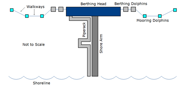
Jetty
A structure projecting from the shore out into the water to allow ships or boats to come alongside for mooring or loading/unloading. Jetties are rateable as part of the land.
Shore-arm or Approach-way
These are jetty structures that provide walkways or roadways and sometimes pipe-racks from shore to boat or ship berths located in deeper water. The typical form of construction is an open structure comprising a suspended reinforced concrete deck supported by steel tubular piles, however structures in shallower water may use a closed structure using granular infill between a pair of walls with ties between.
Berthing heads
Berthing heads are jetty structures that vessels berth against (‘berth’ means the ship is tied up to the jetty or dock) and may incorporate strongpoints with berthing and mooring structures. They are typically located in deeper water.
Berthing dolphin
Berthing dolphins are freestanding structures, (usually secured by piles to the sea or riverbed), that are used to bring a vessel to a halt by absorbing the energy from its approach speed, through fender units that are mounted to the face of the structure.
Mooring dolphin
A mooring dolphin is a structure designed to resist mooring line (rope, cable or chain) tensions, rather than berthing impact forces. Generally, the loading applied to mooring dolphins is less than berthing dolphins, with mooring loads resisted by lines fixed to multiple structures.
Catwalks or walkways between dolphins
A catwalk or walkway is a pedestrian bridge providing operational or maintenance access to offshore dolphins. Load bearing capacity is typically low, as the walkway capacity is limited by the width of the walkway. The structures are typically fabricated offsite, using steel or aluminium sections and are delivered as completed items.
Figure 1 below illustrates a typical layout for some of the above items.
Pontoon
Pontoons are floating platforms capable of accommodating the berthing of offshore vessels. They are linked to the adjacent land or wharf by a bridge. They are more heavily engineered than the pontoons typically found in marina environments and are normally a concrete structure. Pontoons are attached to dolphins (piles), anchors, and other forms of attachment, which permit the pontoon to move vertically to accommodate changes in water level, whether within a dock or due to tidal changes in a harbour. Dolphins in marina environments will typically be smaller than those referenced elsewhere in this document and are used simply to anchor a pontoon in place.
Dolphin (Marina location)
A vertical pile driven into the sea, river or dock bed which is used as a fixing point for a pontoon.
Quays or wharfs
Quays and wharfs (usually where the sea or river side has been artificially built up to provide a level access for boats or ships to come alongside), provide the vertical interface for ships to berth, moor, load and unload goods, personnel and equipment.
Drydock
A drydock comprises an enclosed dock with the ability to drain it of water to enable vessel construction, repair, and maintenance in a dry environment.
Lock
Locks allow raising or lowering of ships or boats between different water levels. They consist of chambers with gates that can be filled or emptied to match the differing water levels.
Dock or lock gates and caissons
Dock gates and Caisson Gates are watertight barriers located at the entrance or exit of a dock or basin. They control water flow, manage water levels, provide access for vessels, and protect against flooding. Dock Gates are normally steel manufactured gates that can open and close, Caissons are large concrete structures that are ballasted and floated in and out of position at high tide.
Slipways
A slipway is an inclined surface usually made of concrete, generally used for launching, hauling, maintenance and retrieving of vessels, and also the landing of goods and personnel. They can vary significantly in size depending on use.
Dredging
Dredging is the process of excavating or removing sediment, debris, or other material from the bottom of bodies of water, such as rivers, lakes, harbours, or oceans. It is primarily done to deepen waterways, maintain navigation channels, control erosion, restore water bodies, or extract valuable minerals and resources.
Linkspan
A linkspan is a type of movable bridge or ramp used to connect a fixed structure, such as a dock or quay, to a ship or ferry. It provides a secure and stable platform for passengers, vehicles, and cargo to move between the shore and the vessel.
Passenger boarding bridge
A passenger boarding bridge is a mechanical connection bridge between the shore and the boat or ferry to allow passengers to disembark and embark from the vessel to the shore. “Bridges” typically found in marina environments will normally be of light construction.
For further advice, please contact a member of Class Co-ordination Team for Specialist Industrial Contractors property.
Jetties, berths, quays, docks and fenders within a port will be rateable as part of the land from which they project, (see Page 45 paragraph 10.2 of the 2nd Wood Committee Report).
Docks, locks and slipways are part of the land and are rateable as such.
Dock-gates, lock gates and caissons are rateable within Class 3 (h) of the plant and machinery regulations (SI 2000 No. 540 (England)).
Floating pontoons together with bridges or gangways will be rateable, subject to them being in the nature of a building or structure, within Class 4 Table 3 of the plant and machinery regulations.
Structures that project into the water beyond the mean tidal low water mark may fall outside of the Billing Authority boundary, the part of the structure beyond that boundary may not be rateable. However, many waterside boundaries have been legally extended by Acts of Parliament, or via local Acts, specifically to extend them so as to make the whole structure rateable.
The survey should be undertaken on the assumption a full contractor’s test valuation will be carried out. Comprehensive details of the structures and any associated plant and machinery will be required, including construction, age and any refurbishment details.
In relation to the below, the following survey details should be recorded:
Dock Gates
Number of gates and dimensions (height, width and thickness).
Caissons
Internal volume (m3).
Dry Dock
Internal volume (m3).
Pontoons
Measured by reference to the surface area(m2) of the structure: length x width.
Slipways
Measured by reference to the surface area (m2) of the structure: length x width.
Locks
Internal volume (m3).
Berthing Heads
The plan area (m2) and loading capacity are key survey requirements. The plan area should be recorded to include the berthing head and any adjoining pipe-rack. These areas should be recorded separately (i.e. berthing head 1000m2, pipe-rack 1000m2). The loading capacity should be recorded in deadweight tonnes (DWT). Details including surfacing and the type of structure (steel, concrete, timber) should also be noted.
Berthing Head Structures
Includes structures such as ship access or loading arm towers and water cannon towers. The number and type of tower is required. General supporting steelwork should be measured by reference to weight (tonnes).
Walkways or Catwalks
Linear meter run (m). Details of construction should also be noted. i.e. steel or timber, open tread, handrails etc.
Berthing Dolphins
Number and type of dolphins (monopile or multi pile).
Mooring Dolphins
Number and type of dolphins (monopile or multi pile).
Dolphins at a Marina Location
Number of dolphins.
Shore or Riverside Arm to Berthing Head
The plan area (m2) and loading capacity are key survey requirements. The plan area should be recorded to include the roadway and any adjoining pipe-rack. These areas should be recorded separately (i.e. roadway 1000m2, pipe-rack 1000m2). The loading capacity (kN/m2) and the use of the structure should be recorded i.e. is it used for pedestrian loading, for vehicles and/or for heavy loading. Details including surfacing and the type of structure (steel, concrete, timber) should also be noted.
Bridges
Measured by reference to the surface area (m2) of the structure: length x width.
For further advice, please contact a member of NVU Industrial Team.
Adjustments to RCG Costs
RCG cost codes 51Z001A, 51Z001B, 51Z001C, 51Z002A, 51Z002B, 51Z003A, 51Z003B, 51Z016, 51Z017 and 51Z019 for jetties, shore-arms, and mooring & berthing dolphins, it is assumed that these structures are located in a deepwater inlet and are associated with a large industrial hereditament. These costs stated in the RCG, have already been adjusted for the factors set out in the cost adjustment notes below and do not require further adjustment.
In respect of all other RCG cost codes within the generic category of ‘Jetties, Maritime and Inland Waterway Structures’ the costs given reflect no addition to cost for the factors set out below and must be adjusted accordingly.
RCG Build Cost Adjustments for Maritime and Inland Waterway Structures
Summary
Estimating build costs for maritime or inland waterway structures is complex and costs are influenced by a host of factors that are not generally found when building on dry land.
How cost influencing factors are measured and accounted for, can be expressed as a measure of ‘risk bias’
Risk Bias
Risk in a project has a significant influence on tendered price. Contractors consider marine (and other ‘wet’ works), as higher risk than land-based works. The estimated allowance for risk can vary significantly from 0% to 50%. Many factors determine risk, for example, when relating to ground condition risk, (whether silt, sand, rock etc.) the quality of the pre-tender design and ground investigation has a significant impact and the ‘passing-on’ of ground risk to a contractor will always attract a significant premium on the tendered cost.
Application of risk bias is a way to address the difference observed in the tendered cost and the outturn cost. The tendered price for a project is based upon the perceived and understood risks at tender, but these can change and be poorly interpreted as the project moves to completion.
The weighting and cost of the risk are a judgement based on knowledge, skill, and experience.
Final project costs can increase with scope changes or additions to the scope. It is seldom that tendered costs are achieved, unless contingencies/provisions are budgeted and risk costs are sufficiently accounted for at tender stage, to cover all the known risks and unknown risks. For example, the tendered cost of a particular jetty could be £30m and the outturn might be £100m+.
The use of risk bias in cost estimation relies on skill and judgement, it is not prescriptive, what follows is a reasonable framework to apply in considering the final cost to apply.
Application of Risk Bias
Below is the approach to be considered when adjusting from the costs given in the cost guide, to get to an estimate of the actual cost for the specific maritime construction being costed.
Categories of risk bias and recommended adjustments
Risks are categorised in percentage ranges for three levels of risk, high, medium and low.
1. Security Restriction
Security Clearance requirements on a site, perhaps for the Ministry of Defence, imply that the works could require high levels of security clearance and restrict movement of vehicles, goods or personnel in and out of the site. This would have a direct impact on the cost of the works. Security restriction would normally also mean restrictions in resources due to the level of classification of the works. Additional cost for security clearance, better segregation of the works and security arrangements may also apply. There may also be restrictions to deliveries and potential issues with supply chain approvals. The impact on estimated costs would be 0-5%.
High (3% - 5%)
Where there are existing access restrictions and full security clearance required for the works.
Medium (2% - 3%)
Partial security restriction. Site has security restriction but not full.
Low (0% - 2%)
Very limited or no security restrictions, publicly accessible sites.
2. Method Of Working Out Over Water
This considers how work over water would be undertaken; floating plant (barges, jack-up spud leg), building end-over-end, use of temporary or permanent bunds. The use of marine plant in a project can significantly raise cost, this is due to the cost of the associated plant and its availability. Often contractors having to book ‘floating‘ plant well in advance and paying for mobilisation and de-mobilisation costs. The use of end-on-end building is more common but can be expensive due to the more complex method of working and planning. The use of a permanent or temporary bund is cost effective but can still be inherently difficult due to the marine environment. The Impact estimated would be 0-10%.
High (5% - 10%)
Over 50% of the works are constructed with ‘floating’ plant present for the principal construction of the non-land-based elements.
Medium (2.5% - 5%)
Construction proposed for end-on-end working where limited ‘floating’ plant is required to set up initial temporary works.
Low (0% - 2.5%)
Works are intended to be done on temporary or permanent bund.
3. Tidal Restriction - Water Depth
The depth of water shall be considered from chart datum. The conversion from Ordnance Datum to Chart Datum varies around the UK. The depth of water has an adverse influence on the cost of design and construction of structures that may require specialist plant. The impact estimated would be 0-10%
High (5% to 10%)
Depth of ≥20m
Medium (2.55% - 5%)
Depth of ≥ 20m < 10m
Low (0% - 2.5%)
Depth of < 10m
4. Tidal Restriction – Tidal Range and Reach
in areas around the UK significant variation occurs in the tidal patterns from the significant range of 10m+ to 1m in the region west of the Argyll peninsula. The impact estimated would be 0-5%.
High (2.5% - 5%)
Tidal range of ≥8m
Medium (0% - 2.5%)
Tidal range of ≥ 3m and < 8m
Low (0%)
Tidal range of < 3m
5. Environmental Conditions and Exposure
The location and orientation of the site will influence the works, via variances in weather, wind, wave, swell, and current at the land sea interface (bathymetry and topography). This is directly related to the exposure of the site to the environmental condition geographically, sheltered areas would be at a lower risk compared to highly exposed sites. The fetch (uninterrupted distance over which wind blows across a body of water, generating waves) and direction of the fetch, would be a measure of exposure. The impact estimated would be 0–10%
High (5% - 10%)
Site is exposed, no protection from breakwater or other structures, not enclosed, where the wave fetch is 250km+.
Medium (0% - 5%)
Site is exposed, no protection from breakwater, not enclosed where the wave fetch is less than < 250km.
Low (0%)
Site is sheltered, protected by a breakwater or other structure, enclosed fetch of less than < 100km.
6. Environmental Designation Affecting the Work
The marine environment around the UK contains many designations; Sites of Scientific Interest (SSSI), Ramsar wetlands, Marine Protected Areas (MPA), Special Areas of Conservation (SAC), Special Protection Areas (SPA), Bird Directive, Marine Species or habitats listed in the Habitats Directive, etc. This could make work more onerous and require additional approval with additional staff, (for example Environmental Clerk of Works, Marine Mammal observers), noise monitoring, working only at certain times, etc. If there is an Environmental designation, there can be an estimated 0 to 5% Impact.
High (2.5% - 5%)
Site or adjacent area is designated under statutory regulation. Mitigation is required as part of the works to avoid, manage and limit impact on the works.
Medium (0% - 2.5%)
Site or adjacent area has limited designation under statutory regulation. Limited mitigation and impact on the works.
Low (0%)
Site or adjacent area has no designation, and no mitigation is required for the Works.
7. Operational Requirement or Limitations
Works being undertaken in operational (live site) areas where there may be restrictions. For example, works being undertaken while operations are ongoing (perhaps in a ferry terminal, while the ferry is operating, and upgrade works are being undertaken), can impact the cost of associated works. For example, where there is a ferry timetable, associated berthing movements, loading and offloading of good, etc. These depend on the level of restriction and limitation, which can impact the works estimated from 0-20%.
High (10% - 20%)
Site is live operational port or harbour, timetables services, interactions with the public and commercial traffic.
Medium (5% - 10%)
Site is adjacent to live operational port or harbour, timetables services, interactions with the public and commercial traffic. Where there is limited impact on the Works.
Low (0% - 5%)
No requirements to low levels of requirements / restrictions / limitations of working.
8. Known Ground Conditions
The impact of the underlying geotechnical conditions and the requirements to transfer load, from the structure into the underlying structure, to support the loads, is key to the success of a project. Where ground conditions are known and specific ground investigation has been carried out, the impact on the geotechnical conditions is translated to the design. In marine works the ground can vary significantly. Where there are changeable conditions, this will pose a significant risk to cost. Where there are poor conditions for supporting the structure, this could also have a significant impact on cost, especially where soft ground could mean more onerous design and construction. It is often difficult to measure the impact, but a variance of 10% on the overall contract cost, would be reasonable when considering the impact to design and construction. Estimated impact 0-15%.
High (7.5% - 15%)
Poor underlying ground condition layer and thick bands of soft material with SP(N) <10 and in variable ground where obstructions have been encountered in the ground investigation.
Medium (2.5% - 7.5%)
Reasonable underlying ground conditions SP(N) ≥10 and SP(N)< 30. Also considered for shallow weathered rock encountered requiring drilling and rock socketing.
Low (0% - 2.5%)
Competent ground with SP(N) ≥ 30. Low risk of obstruction and competent rock found in a reasonable distance for toe in of pile with no drilling or grouting required.