Road Lengths in Great Britain: 2020
Published 4 February 2021

© Crown copyright 2021
This publication is licensed under the terms of the Open Government Licence v3.0 except where otherwise stated. To view this licence, visit nationalarchives.gov.uk/doc/open-government-licence/version/3 or write to the Information Policy Team, The National Archives, Kew, London TW9 4DU, or email: psi@nationalarchives.gov.uk.
Where we have identified any third party copyright information you will need to obtain permission from the copyright holders concerned.
This publication is available at https://www.gov.uk/government/statistics/road-lengths-in-great-britain-2020/road-lengths-in-great-britain-2020
About this release
This annual release presents estimates for road lengths in Great Britain maintained at public expense. These estimates are based on information from a range of sources, including Ordnance Survey and local authorities. The majority of the data relate to the time point of April 2020. Detailed statistical tables can be accessed online via the road length statistical series.
To note, some of the figures in this release may not sum due to rounding.
Main findings in this release
In 2020, the total road length in Great Britain was estimated to be 247,500 miles.
There were 31,800 miles of major road in Great Britain in 2020, consisting of:
- 2,300 miles of motorway (99% trunk, 1% principal)
- 29,500 miles of ‘A’ road (18% trunk, 82% principal)
There were 215,700 miles of minor road in Great Britain in 2020, consisting of:
- 18,900 miles of ‘B’ road
- 196,800 miles of ‘C’ and ‘U’ roads
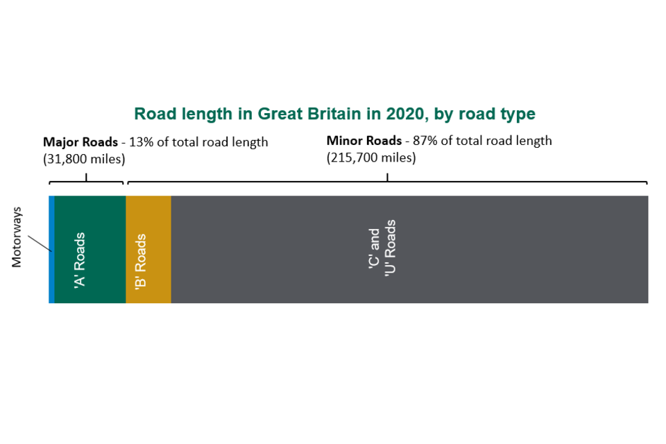
Stacked bar chart showing the variation in road lengths across Great Britain by different road types
Roads in Great Britain
By length, most roads in Great Britain are managed locally (by a local highway authority or Transport for London). This includes all minor roads (‘B’, ‘C’ and ‘U’ roads), and some major roads (principal ‘A’ roads and motorways).
The rest of the major roads (trunk motorways and ‘A’ roads) are managed centrally by Highways England (formerly the Highways Agency), Transport Scotland, and the Welsh Government.
Motorways, ‘A’, ‘B’ and ‘C’ roads are classified roads, and ‘U’ roads are unclassified. ‘U’ roads are typically residential streets or rural lanes.
Trends Over Time
In 2020, there were 247,500 miles of road in Great Britain. This was 2,600 more miles than a decade earlier in 2010 (a 1.1% increase), and 5,000 more miles than in 2000 (a 2.1% increase).
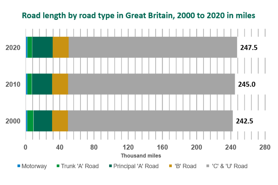
Stacked bar chart showing the variation in road lengths across the last 3 decades: 2000, 2010 and 2020
There were 700 more miles of major road in Great Britain in 2020 than in 2000, a 2.3% increase, with motorways contributing 100 miles and ‘A’ roads contributing 600 miles of that increase. Whilst the overall length of ‘A’ roads increased by 600 miles between 2000 and 2020, the length of trunk ‘A’ roads decreased by 1,800 miles and the length of principal ‘A’ roads increased by 2,400 miles. This largely reflects the Government’s de-trunking programme where centrally managed roads were transferred over to local authorities, with most transfers carried out between 2001 and 2003.
There were 4,300 more miles of minor road in Great Britain in 2020 than in 2000, almost entirely driven by an increase in ‘C’ and ‘U’ roads.
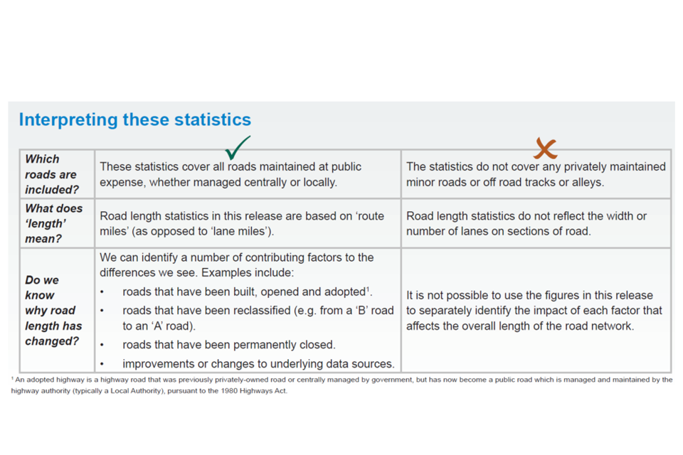
A table showing how to interpret these statistics. Essentially these statistics only cover roads maintained at public expense, whether managed centrally or locally
Road Length by Country
Of the 247,500 miles of road in Great Britain in 2020:
- 189,700 miles (77%) of road were in England
- 36,800 miles (15%) were in Scotland
- 21,000 miles (9%) were in Wales
The table and charts directly below show the varying composition of each country’s road network by road type.
Breakdown of road length (thousand miles) by country and road type in 2020
| Country | Major Roads: Trunk | Major Roads: Principal | Major Roads: All | Minor Roads: ‘B’ roads | Minor Roads: ‘C’ and ‘U’ roads | Minor Roads: All | Total |
|---|---|---|---|---|---|---|---|
| England | 4.5 | 17.8 | 22.4 | 12.4 | 154.9 | 167.3 | 189.7 |
| Scotland | 2.1 | 4.6 | 6.7 | 4.6 | 25.5 | 30.1 | 36.8 |
| Wales | 1.1 | 1.7 | 2.7 | 1.9 | 16.4 | 18.3 | 21.0 |
| Great Britain | 7.7 | 24.1 | 31.8 | 18.9 | 196.8 | 215.7 | 247.5 |
Breakdown of road length (%, percentage) by country and road type in 2020
| Country | Major Roads: Trunk | Major Roads: Principal | Major Roads: All | Minor Roads: ‘B’ roads | Minor Roads: ‘C’ and ‘U’ roads | Minor Roads: All | Total |
|---|---|---|---|---|---|---|---|
| England | 2 | 9 | 12 | 7 | 82 | 88 | 100 |
| Scotland | 6 | 13 | 18 | 12 | 69 | 82 | 100 |
| Wales | 5 | 8 | 13 | 9 | 78 | 87 | 100 |
| Great Britain | 3 | 10 | 13 | 8 | 80 | 87 | 100 |
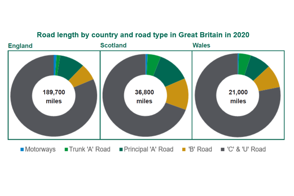
3 pie charts showing the variation in road length by country (England, Wales and Scotland) and road type
The Strategic Road Network (SRN) consists of all trunk motorways and trunk ‘A’ roads in England. In 2020, the SRN was 4,500 miles long and made up 2% of the total length of road in England. By comparison, trunk roads made up a higher proportion of roads in Scotland (6% of total road length) and Wales (5%). The composition of these trunk roads differed in each country, with 42% of trunk roads classified as motorways in England, compared to only 8% in Wales and 14% in Scotland.
In 2020, a higher proportion of the road network in Scotland consisted of major roads (18%) compared with England (12%) and Wales (13%). A greater proportion of ‘A’ roads were classified as principal in England (87%) compared to Scotland (72%) and Wales (63%).
Scotland and Wales estimates
Scotland and Wales produce their own estimates of length.
Rural and Urban Breakdowns
In 2020, the majority of road length in Great Britain was rural, with 76% of ‘A’ roads, 81% of ‘B’ roads, and 58% of the combined ‘C’ and ‘U’ roads classified in this way.
Just as the composition of the road network by road type varied between England, Scotland and Wales, so did the proportion of urban and rural road length. England had a lower proportion of minor roads classified as rural (57%) than Scotland (68%) or Wales (77%). England also had the lowest proportion of rural ‘A’ roads out of the three countries.
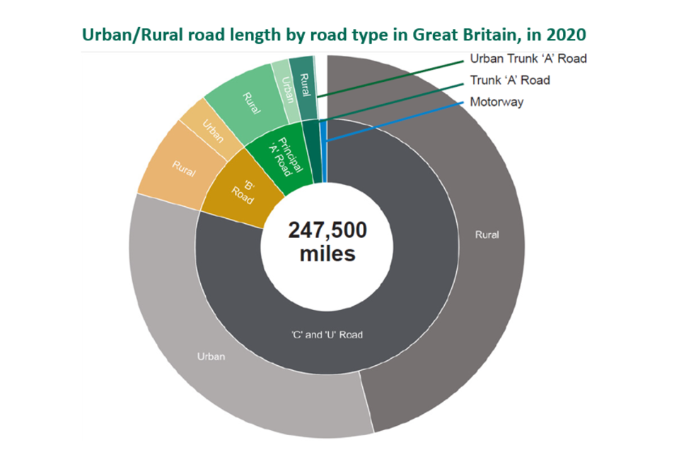
Sunburst pie chart which shows the proportion of road length in Great Britain segmented by road type and urban and rural classification
Rural and Urban classifications
The classifications are based on the latest definition published by the Office for National Statistics for England and Wales (using 2011 census), and the 2013 to 2014 definition published by the Scottish Government for Scotland.
Background Information
Rounding
Figures quoted in this publication are rounded to the nearest 100 miles. Raw differences and percentage changes are always calculated from unrounded numbers.
Methodology changes
Ongoing improvements to the accuracy of data sources and methodology may account for some of the slight changes between years.
Further technical and methodological information
Traffic and Road Length in England
Vehicle activity is unevenly distributed across Great Britain’s road network. Road traffic estimates for 2020 are provisionally due to be published in June 2021, and so were unavailable at the time of publication. In 2019, 62% of the motor vehicle miles travelled were on motorways and ‘A’ roads, despite comprising only 13% of the road network by length.
On an average day in 2019, 75 times more vehicles travelled along a typical stretch of motorway than a typical stretch of rural minor road (‘B’ roads, ‘C’ roads and unclassified roads).
Urban and Rural Methodology
There have been no significant methodology changes for the publication this year.
For 2017, the department improved the methodology used to calculate urban and rural road lengths, so that urban and rural road length estimates are calculated consistently across major and minor roads, and are more precise.
Data for years prior to 2017 are still based on the older classification (2001 for England and Wales). Scotland have recently updated their Urban/Rural Classifications. We will be making use of this newer classification for Scotland in the 2021 series for Road Length Statistics, following a review of the data. More information on the Urban/Rural classifications used in the 2020 Road Length Statistics can be found at the following links:
- 2011 ONS definition for England and Wales
- 2011 ONS Built-up Areas Methodology for England and Wales
- Scottish Government 2013-14 Classification
National Statistics
National Statistics are produced to high professional standards set out in the Code of Practice for Official Statistics. They undergo regular quality assurance to ensure customer needs are met. Details of ministers and officials who receive pre-release access to these statistics up to 24 hours before release can be found in the pre-release access list
Further information about these statistics is available, including:
-
Road Length Statistics: data tables
-
Road Length Statistics: notes and definitions
Future road length statistics publications
The department is continuing to assess how the OS MasterMap Highways Network dataset can be used to produce improved estimates of road length in future.
The product is continuously being developed with Ordnance Survey (OS), GeoPlace and other stakeholders. If you have any questions, please email road length statistics
We are trialling the HTML format for our road length releases, and we would like to hear your comments. If you have any feedback on our use of this format, please email road length statistics