MOD Land Holdings: 2000 to 2026
Published 28 May 2026

© Crown copyright 2026
This publication is licensed under the terms of the Open Government Licence v3.0 except where otherwise stated. To view this licence, visit nationalarchives.gov.uk/doc/open-government-licence/version/3 or write to the Information Policy Team, The National Archives, Kew, London TW9 4DU, or email: psi@nationalarchives.gov.uk.
Where we have identified any third party copyright information you will need to obtain permission from the copyright holders concerned.
This publication is available at https://www.gov.uk/government/statistics/mod-land-holdings-bulletin-2026/mod-land-holdings-2000-to-2026
This is an annual publication which provides figures on Ministry of Defence (MOD) land holdings in the UK by top level budget holder, country, type of use and whether owned, leased or with legal rights.
This edition provides statistics for 2000 to 2026 (figures are given for 1 April each year), and updates figures released in the 2025 edition of this publication, which provided statistics up to 1 April 2025.
This publication does not provide information on the overseas Defence estate and includes land declared as surplus to defence requirements.
1. Main Points and Trends
- On 1 April 2026, the MOD owned 230,500 hectares of land and foreshore in the UK (either freehold or leasehold), which is about 0.9% of the total UK land mass[footnote 1]. The MOD also held rights over a further 110,800 hectares, which is a further 0.5% of the total UK land mass. On 1 April 2026, the total UK land holdings for the MOD was 341,300 hectares (1.4% of the total UK land mass).
-
Since 1 April 2025, the total land holdings have decreased by 100 hectares.
-
The Army had the largest area of land owned or with rights held on 1 April 2026, at 252,800 hectares (74.1% of the MOD total). This represents a 5,500 hectares decrease on the previous year.
-
England accounts for the largest portion of land owned or with rights held, at 251,500 hectares (73.7% of the MOD total), an increase of 100 hectares since 2025.
-
Training areas and ranges occupy the largest area at 259,500 hectares (76.0% of the MOD total, this includes land which is owned, and that MOD has legal rights over), a decrease of 100 hectares since 2025.
Further information: DIODEx-GeospatialAndAnalytics@mod.gov.uk
Responsible statistician: Analysis-ChiefStatsOffice@mod.gov.uk
Background quality report: Background quality report
Would you like to be added to our contact list, so that we can inform you about updates to our statistics and consult you if we’re thinking of making changes? You can subscribe to updates by emailing DIODEx-GeospatialAndAnalytics@mod.gov.uk
Please refer to the Supplementary tables containing all data presented in this publication.
2. Introduction
The Ministry of Defence (MOD) is one of the largest landowners in the country, operating over an estate approximately equal to 1.4% of the UK land mass. MOD sites are used for training, accommodation and providing a base from which operations can be instigated. The estate is currently managed by the Defence Infrastructure Organisation (DIO) and third-party organisations, who have a remit to ensure the safety, sustainability, and rationalisation of the estate. The MOD has published land holdings and building statistics since 1981.
The information in this publication, and the accompanying supplementary tables, have been taken from the Infrastructure Management System (IMS). IMS was implemented by DIO in 2014 as a mechanism to manage the defence infrastructure more effectively. Prior to the implementation of IMS, an asset verification exercise took place to capture accurately the defence estate. DIO have a clear process to ensure that IMS is updated with any changes to the estate, so the information about the defence estate is reflective of the current situation. A number of inclusions and exclusions apply to the figures in this publication. Further details of these can be found in the Methodology section of the report and Background Quality Report.
2.1 Accredited Official Statistics publication
Accredited Official Statistics are called National Statistics in the Statistics and Registration Service Act 2007.
These Accredited Official Statistics were independently reviewed by the Office for Statistics Regulation in 2017. They comply with the standards of trustworthiness, quality and value in the Code of Practice for Statistics and should be labelled ‘Accredited Official Statistics’.
Accreditation can be broadly interpreted to mean that the statistics:
-
meet identified user needs;
-
are well explained and readily accessible;
-
are produced according to sound methods; and
-
are managed impartially and objectively in the public interest.
Further information on the accreditation process can be found here: Accreditation explanation web page
Once statistics have been designated as Accredited Official Statistics it is a statutory requirement that the Code of Practice shall continue to be observed. Further details about how this report has been developed since its confirmation as an Accredited Official Statistic can be found in the Background Quality Report.
Our statistical practice is regulated by the Office for Statistics Regulation (OSR). OSR sets the standards of trustworthiness, quality and value in the Code of Practice for Statistics that all producers of official statistics should adhere to.
You are welcome to contact us directly with any comments about how we meet these standards.
Alternatively, you can contact OSR by emailing regulation@statistics.gov.uk or via the OSR website.
3. UK Land Holdings for Defence
3.1 UK Land Holdings by Type of Ownership
There are several ways that land can be held by organisations, DIO manages land through the following three ways:
-
Freehold – land which has been bought on a permanent basis.
-
Leasehold– land which is held by an organisation for a definitive period of time.
-
Rights Held – land which is held on a (most usually) short term and contractual basis or through grants for a specific purpose. MOD holds a lot of land in this way because it is a more cost effective and flexible way to meet the changing operational requirements for defence.
As of 1 April 2026, the MOD managed 341,300 hectares of land within the UK. In total, this is about 1.4% of the UK land mass. This is a decrease of 100 hectares over the past year.
Chart 1: Type of holding, as of 1 April 2026
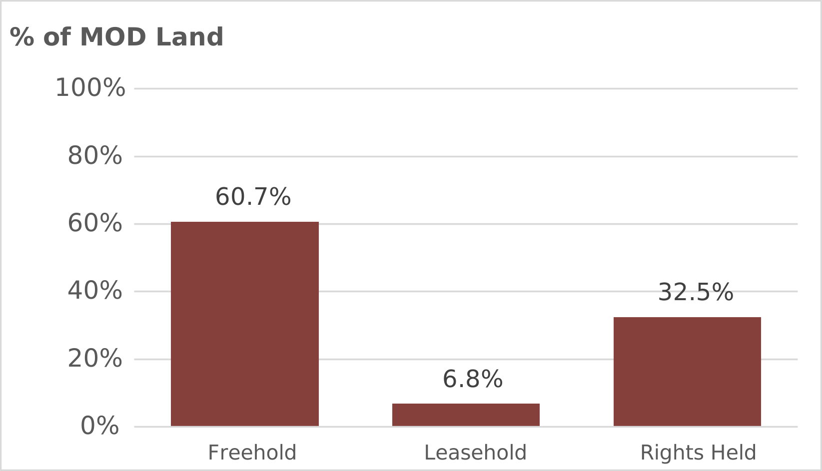
A graph showing the type of holding percentage split for freehold, leasehold and rights held.
Source: DIO (IMS)
Chart 1 shows that just over two thirds (230,500 hectares) of the land was owned (either freehold or leasehold), which is 400 hectares less than the figure reported on 1 April 2025.
On 1 April 2026, the MOD held a further 110,800 hectares through legal rights, which is 200 hectares more than the figure reported on 1 April 2025.
3.2 UK Land Holdings by Top Level Budget Holder
As shown in Chart 2, the Army owned or had rights over the largest area, at 252,800 hectares (74.1% of the MOD total), and much of this comprises of the training estate (94.0% of the Army’s land holding is training estate).
Chart 2: Top Level Budget holder, as of 1 April 2026
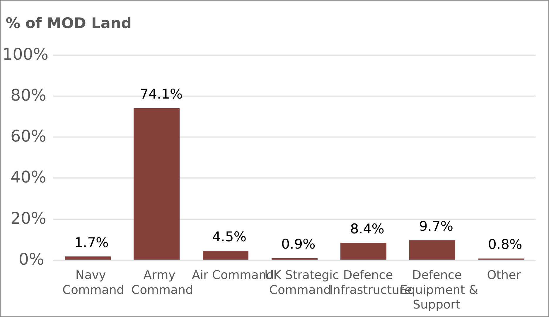
A graph showing the top level budget holder area percentage split.
Source Data: DIO (IMS)
The ‘Other’ category in chart 2 includes Head Office, Defence Business Services, Ministry of Defence Police and Trading Funds (such as Defence Science and Technology Laboratory, and UK Hydrographic Office).
Navy Command includes the Defence Nuclear Organisation.
3.3 UK Land Holdings by Country
On 1 April 2026, the majority of land holdings were in England. The England land holdings were 251,500 hectares (73.7% of the MOD total), an increase of 100 hectares since 2025.
As of 1 April 2026, the Scotland land holdings stood at 64,700 hectares (19.0% of the MOD total), the Wales land holdings were 23,300 hectares (6.8% of the MOD total), and the Northern Ireland land holdings were 1,800 hectares (0.5% of the MOD total). Land holdings in Scotland and Wales have decreased by 100 Hectares since 2025, whilst Northern Ireland land holdings have remained largely the same.
Chart 3: Type of land held by country, as of 1 April 2026
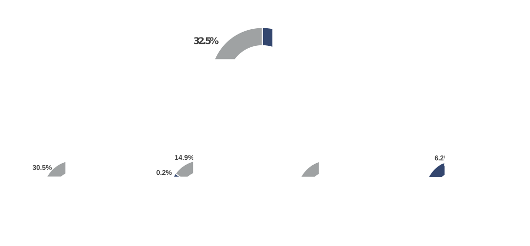
A graph showing the type of land held by all MOD then by the UK home countries.
Source: DIO (IMS)

A map showing the type of land held by the UK home countries.
3.4 UK Land Holdings by Type of Use
Chart 4 below shows that on 1 April 2026 training areas and ranges occupied the largest area, at 259,500 hectares (76.0% of the MOD total), a decrease of 100 hectares since 2025. In terms of the land that the MOD holds legal rights to, training areas and ranges make up 98.9% (109,600 hectares out of the total 110,800 hectares).
Research and Development occupies 35,700 hectares (10.5% of the MOD total) which has decreased by 100 hectares compared to 2025. Reserve Forces and Cadet Associations usage has also decreased by 100 hectares, to 2,200 hectares. The Airfields use has increased by 200 hectares to 15,300 hectares. All other types of use have remained broadly the same.
Chart 4: Type of use, as of 1 April 2026
A graph showing the type of use percentage split for airfields, training area and ranges, barracks and camps, storage and supply depots, research and development, and other.
Source: DIO (IMS)
Detailed figures on the MOD’s UK land holdings at 1 April each year since 2000 can be found in Table 1 (by top level budget holder), Table 2 (by country) and Table 3 (by type of use): MOD Land Holdings Bulletin Index
4. Methodology
The Defence Infrastructure Organisation (DIO) is the estate expert for defence, supporting the armed forces to enable military capability by planning, building, maintaining, and servicing infrastructure. We are responsible for enabling defence people to live, work, train and deploy at home and overseas. Our vision is to equip defence with a significantly smaller, more efficient, better quality estate.
For more information, visit the Defence Infrastructure Organisation website
4.1 Data Sources and Quality
The land holding figures are derived from the DIO Infrastructure Management System (IMS) which contains information on all non-sensitive property assets that are owned, occupied or over which the MOD hold rights. The figures in the publication do have notable inclusions and exclusions which are as follows (these caveats apply to all figures from 2011):
-
The figures presented include land occupied by all MOD TLB holders (including United States Visiting Forces (USVF) occupied sites); all Trading Funds and Agencies (including Defence Science & Technology Laboratory (DSTL) and the Hydrographic Office).
-
Civil estate (for example offices) owned by MOD that are currently being used by another Government Department, and not at all by MOD, are excluded.
-
The reserve (or volunteer) estate is included from 2016, this is due to a data quality improvement. Comparable figures for earlier years are not available.
-
The Rights figures for England & Scotland include those agreements where Training on Private Land (ToPL) has been formalised with the landowner through a legal agreement.
-
In Wales significant amounts of ToPL occurs on an informal agreement basis so these figures are not included. As most of the land held under Rights agreements is used for training, which is driven by operational requirements, the extent of Rights held can vary significantly from year to year.
-
Information on PFI (Private Finance Initiative), dockyard, and AWE (Atomic Weapons Establishment) assets are currently being reviewed, any updates will be reflected in later publications.
-
Changes to the estate which have not been captured on IMS at the time the data was extracted for this bulletin are not included.
Data quality improvements to the IMS were reinforced as a result of recommendations from the National Audit Office 2010 report: ‘A Defence Estate of the Right Size to meet Operational Needs’. Further information about these improvements and other aspects of data quality can be found in the Background Quality Report.
5. Further Information
5.1 Rounding
Within this publication, all figures have been rounded to the nearest hundred hectares or to one decimal place for percentages. Where rounding has been used, totals and sub-totals have been rounded separately and so may not equal the sums of their rounded parts.
5.2 Revisions
There are no revisions to this edition.
Corrections to the published statistics will be made if errors are found, or if figures change as a result of improvements to methodology or changes to definitions. When making corrections, we will follow the Ministry of Defence Statistics Revisions and Corrections Policy. All corrected figures will be identified by the shorthand [r], and an explanation will be given of the reason for and size of the revision. Corrections which would have a significant impact on the utility of the statistics will be corrected as soon as possible, by reissuing the publication. Minor errors will also be corrected, but for convenience these corrections may be timed to coincide with the next annual release of the publication.
5.3 Contact Us
This publication has been produced by the Data Exploitation team in the Defence Infrastructure Organisation.
We welcome feedback on our statistical products. If you have any comments or questions about this publication or about our statistics in general, you can contact us as follows:
SPF Infrastructure Data Science (DIO)
Email: DIODEx-GeospatialAndAnalytics@mod.gov.uk
If you require information which is not available within this or other available publications, you may wish to submit a Request for Information under the Freedom of Information Act 2000 to the Ministry of Defence.
If you wish to correspond by mail, our postal address is:
Infrastructure Data Science (Accredited Statistics)
Defence Infrastructure Organisation Head Office
St George’s House
DMS Whittington
Lichfield
Staffordshire
WS14 9PY
-
The best recorded estimate of total UK land mass 244,376km2 or 24,437,600 hectares. This figure is published by United Nations Statistics and can be found in ‘World Summary: Table 3 - Population by sex, annual rate of population increase, surface area and density’, on page 9 of the following link: Demographic Yearbook – 2024 ↩