Strategic Environmental Assessment
Published 4 April 2016

© Crown copyright 2016
This publication is licensed under the terms of the Open Government Licence v3.0 except where otherwise stated. To view this licence, visit nationalarchives.gov.uk/doc/open-government-licence/version/3 or write to the Information Policy Team, The National Archives, Kew, London TW9 4DU, or email: psi@nationalarchives.gov.uk.
Where we have identified any third party copyright information you will need to obtain permission from the copyright holders concerned.
This publication is available at https://www.gov.uk/government/publications/the-environment-and-safety-at-dounreay/strategic-environmental-assessment
Site Specific Baseline Dounreay
Published by NDA and Dounreay September 2014
An Environmental and Sustainability Report was published by the NDA as part of the Strategic Environmental Assessment (SEA) of the NDA Strategy. It was produced in compliance with the SEA Directive (2001/42/EC) and transposing regulations (S.I.1633, 2004).
The following pages contain specific baseline information for the Dounreay site, and a map of the local area. This information was used in the preparation of the Environmental and Sustainability Report and regularly updated information will be used as part of monitoring measures to identify trends in potential environmental impacts. A short introduction is followed by a table containing the current baseline information, organised by sustainability headings. The final section includes information about future developments and environmental issues.
The NDA and DSRL are committed to sharing information and making it accessible to all. In making this non-confidential environmental and sustainability information available we believe that it will provide a useful ongoing resource to the general public and stakeholders.
Dounreay
The Dounreay nuclear facility is located in Caithness and covers an area of 54 hectares. Construction of the site began in 1955, and all reactor and processing operations ceased in 2006. The site is currently undergoing decommissioning with an interim end state (IES) date of 2022-2025. The programme involves the removal of major hazards and construction of new waste treatment facilities. The programme also involves the coordinated removal of the majority of the buildings, conditioning of wastes for on-site interim storage and the planned disposal of Low Level Waste (LLW) in a new off-site facility. Interim storage of conditioned Intermediate Level Waste (ILW) will continue indefinitely until other arrangements are made, in line with published Scottish Government strategy which requires near site, near surface management. Contingency arrangements for greater than 100 years of storage are being made. The site may be released from its nuclear site licence by 2333, subject to the storage strategy developing further.
Site end state assumption
The preferred end state for the Dounreay facility is for the site to be restored to a point when the site would be de-licensed by 2333, the Final End Point. All work to restore the site will be completed by the IES. Some residual contamination, redundant site infrastructure, and foundations will be left in-situ unless there is an over-riding safety or regulatory requirement.
Current environmental baseline
Table 2: Baseline data across all topics for Dounreay
| SEA objective | Key environmental baseline | Source |
|---|---|---|
| Air Quality | Previous studies have shown that baseline levels of a number of key (non-radioactive) pollutants such as benzene; 1,3-butadiene; carbon monoxide; nitrogen dioxide; and particulates (PM10) are comfortably below the relevant UK air quality strategy objectives. SEPA has granted DSRL an authorisation under the Radioactive Substances Act 1993 (as amended). Dounreay discharges gaseous radioactive wastes to the atmosphere via numerous stacks that are grouped into 3 groupings on the basis of stack height. As part of this authorisation, SEPA has placed rolling 12- month limits on the activity that can be discharged according to the radionuclide or group of radionuclides in the discharge. Alpha, beta and tritium discharges have typically been a very small fraction (single figure percentages) of the corresponding authorised discharge limits. For the rolling 12-months to the end of April 2014, the highest alpha and beta aerial discharges from the site were from the FCA North and South Stacks grouping. In the same period the highest tritium aerial discharges were from the PFR main stack grouping. It should be noted that a new RSA Authorisation became effective on the 24th April 2014 and future submissions of this report will relate to the new authorised discharge limits. | Prepared for UKAEA by Atkins (2004) Dounreay Site Wide Environmental Statement (SWES) Air Quality Baseline Report. The April 2014 Monthly Report of Discharges in Compliance with the RSA Authorisations*. Issue 1. Assurance/RSA/Apr14 |
| Global Climate Change and Energy | From March 2014 through Aug 2014, the operations at Dounreay resulted in the release of 11326 tonnes of CO2 indirectly through the consumption of 15.2 GWh (54.9 TJ) of electricity and directly with the consumption of both heavy fuel oil (37.4 TJ) and kerosene (6.1 TJ). During this period Dounreay consumed a total of 98.4 TJ of energy, which represents a 14% decrease from the previous 6 month period, which is consistent with anticipated seasonal variation. The majority of the Dounreay site is located approximately 20m Above Ordnance Datum (AOD). Studies have been conducted to consider rates of coastal erosion, in particular, in relation to the coast line adjacent to the ILW Shaft. Coastline recession rates of around 1-2m in 200 to 300 years have been estimated, taking into account sea level rise. The Shaft will have its waste inventory retrieved prior to IES such that there will be no short-term operational issues associated with coastal erosion over this period. The existing LLW disposal facility will have its waste inventory retrieved unless a case is made that it is safe to remain in situ. In the longer term, parts of the site will be more susceptible to sea level rise and coastal erosion over timescales of several hundred to thousands of years, if no additional mitigation measures are applied. In practice, such issues have been considered within the development of site end state options and the development of the new Dounreay LLW disposal facilities, which are currently under construction. | NDA (2005) Dounreay EAPINS Project Questionnaire; Nexia Solutions (2008) Position paper on climate and landscape change effects at NDA sites; NDA (2008) Site Operator Input DSRL internal records (energy utilisation) provided by Neil Smith |
| Biodiversity, Flora and Fauna | There are no designated conservation sites identified on the site. There are, however, Sites of Special Scientific Interest (SSSIs), Special Areas of Conservation (SACs), Special Protection Areas (SPAs), and Ramsar and Ancient Woodland Inventory (AWI) sites in the surrounding area. Part of the Sandside Bay SSSI is within land owned by the NDA and leased to a farming tenant. It is notable for its dunes and links habitat and coastal vegetation communities. UKAEA (2002) Dounreay Environmental Statement UKAEA (2006) LLW Facilities Environmental Statement; Environment Agency Dounreay NLLWF Translocation of Primula Scotica (2011) SNH (2009) Dounreay Site Specific Baseline 5 September 2014 A number of protected species were recorded on, or next to the site, including Otters, (European Protected species under Annex IV of the Habitats Directive) and breeding birds, such as Arctic Tern. Species of flora including the Oyster Plant, which is nationally uncommon, are found on the Dounreay beach and the nationally uncommon Scottish Primrose which is confined to Caithness, Orkney and North Sutherland. Primula scotica are protected and found to the east of the site. Approximately 4,000 primroses were translocated and fenced off to prevent any damage during the construction phase of the new LLW disposal facilities. In 2010, an area of approximately 25,000m2 (2.5 hectares) on the Dounreay site was identified for a bee meadow. The north coast of Scotland is home to some of the rarest species of bee in the UK including the Great Yellow Bumblebee and the UK Biodiversity Action Plan priority species, the Moss Carder Bee. The Bumblebee Conservation Trust advised the site that any land providing foraging in the Dounreay area would add a link to other bee foraging areas around the north coast. Wild flowers were encouraged in the meadow, supplemented by a specific mowing regime that would encourage the bees. A number of bees recorded during 2011 and 2012 included the rare Great Yellow and Moss Carder species. Other recorded species included the White Tailed, Common Carder, Garden, Broken Belted and Cuckoo Bumblebees. Significant positive media coverage of the project has been generated during this time. The new 2014-2016 Biodiversity Action Plan includes the Bee Meadow Project which was a successful project in the last Dounreay BAP. The Bee Meadow Project began in 2010 and was set up as a foraging area to encourage the rare Great Yellow Bumblee species and each year the Great Yellow Bumblee species have been identified in the Dounreay Bee Meadow. Each year the Bee Meadow is cut (the latest cut was at the end of August 2014) and wildflowers are planted to reduce the grass species in the meadow. Some of the wildflower species include Kidney Vetch, Common Knapweed, Meadow Vetchling, Birds-foot Trefoil, Yellow Rattle, Devils-bit Scabious, Red and White Clover, Meadow Foxtail to name a few. Bee surveys were completed during the summer months and the bee species identified in 2014 include; the Great Yellow Bumblebee, White Tailed, Carder and Garden Bee. The area next to the meadow will be developed into a ground-nesting bird habitat which uses the grass cuttings from the Bee Meadow. One of the new projects in the 2014-2016 BAP is to develop the area adjacent to the new laboratory facilities with wildflower species (instead of planting grass seed) to enhance biodiversity. This area was available to develop and has now been seeded with different wildflower mixes. This area will be monitored to identify the successful species. Another project in the BAP is the vegetative plot trial project, undertaken by UHI. This is being completed to inform the site end state landscaping design. Smaller scale pot trials were undertaken over one growing season to inform the plot trials. This project identified; the best material and grading for subsoil, a range of ground and surface conditions that support different sustainable vegetation surfaces and identified native, low maintenance species and seed blends . The vegetation plots have now been constructed and will be monitored over the next three growing seasons. All of the actions included in the Biodiversity Action Plan are due to be completed by the end of 2016. A summary of bird species found in the area include Fieldfare; Redwing; Bunting; Snow Bunting; Hen Harrier; Merlin; Whooper Swan and Whimbrel wintering birds (all listed on Schedule 1 of the Wildlife and Countryside Act 1981 and Nature Conservation (Scotland) Act 2004). A holistic approach to biodiversity should recognise that biodiversity is more than just the reflection of designated sites. It is an interrelated network of habitats and species, of which designated sites and species are those that are most fragile or rare and require the highest degree of protection. A Dounreay Biodiversity Action Plan 2011-2013 was published in June 2011. The plan is being developed further beyond 2013 in line with the decommissioning programme as the site is restored | Impact Assessment of Ionising Radiation on Wildlife [http://www.snh.org.uk/about/directives/NCCB433690. pdf]; [http://www.snh.org.uk/pdfs /about/directives/Naturabooklet.pdf] SNH (2009) Citation for Special Protection Area (SPA) East Caithness Cliffs [http://www.snh.org.uk/about/directives/eastcaithB433 704.pdf |
| Landscape and Visual | The Dounreay nuclear site divides a strip of ‘Open, Intensive Farmland’ landscape type, which is situated between the north coast of Caithness and the main coast road, the A836. The region is generally fairly flat, characterised by open rolling countryside with hills west and south of the study area. Dramatic views of Dounreay are gained from a 1.5 km elevated stretch of road west of Sandside Bay, and the Site is generally a significantly noticeable feature of the visual landscape. Dwellings at Upper Dounreay closer to the Site have views of Dounreay as do stretches of the A836 and flanking dwellings, for example Buldoo. The site is also visible from part of the nearby village of Reay. | UKAEA (2006) Dounreay Environmental Statement UKAEA (2007) Results of the Dounreay Site End State Consultation |
| Cultural Heritage | The Dounreay Heritage Strategy was published in September 2010 after a public consultation process. The site’s Heritage Officer is managing the resulting implementation plan, which has a variety of activities that will capture, preserve and celebrate Dounreay’s cultural heritage for public benefit. The Science Museum and National Museums Scotland have proposed a shared acquisition agreement for the DFR Control Room panels and operator’s desk and a draft agreement is awaited for review. The DMTR Control Room panels and operator’s desk have undergone the site’s internal clearance process and will be donated to Caithness Horizons in late 2014. Work is on-going to provide a structural frame for display purposes and renovate some panels. James Gunn, DSRL Heritage Officer and member of the International Scientific Advisory Committee for the Defence Heritage international conference being organised by the Wessex Institute of Technology in September 2014, has successfully submitted a paper for the conference. History reports for 16 previously demolished buildings were written and approved. Oral history interviews with 3 ex-employees were recorded. The oral history work was featured in the June 2014 edition of the Dounreay News. Two Dounreay Memories forms were submitted by leavers, recording their memories of working at the site. Nine heritage objects were collected. A presentation about the history of the fast reactor project was given to staff by C Gregory, ex-Dounreay Deputy Director. | DSRL (2009) Dounreay Heritage Strategy: Delivering a cultural legacy through decommissioning (SES(09)P007) http://www.dounreay.com/site-closure/heritage |
| Groundwater, Geology and Soils | Dounreay is underlain by rocks of the Caithness Flagstone Formation. These are predominantly grey siltstones with minor sandstones and limestones. The rocks are indurated (hardened) with very low porosity. Overlying Quaternary deposits are generally greater than 3m thick. No geological features of special importance have been identified. The solid strata and overlying deposits at the Site are typical of the much wider area and as such, there are no scarce or locally restricted deposits of note. The Scottish Soil Framework indicates that there are a number of soil types in the area, notably mineral gleys. Permeability is generally low and associated with fracturing, although the rocks are capable of yielding small amounts of water to wells (approximately 10 m 3 per day). In common with the rest of mainland Scotland, the rocks are designated as a groundwater body in the context of the Water Framework Directive, and a drinking water protected area. The groundwater quality in the area is considered to be generally good, although groundwater towards the coast becomes saline in winter. Groundwater in some small areas of the site is known to be impacted by radioactive contamination. Control measures are in place for this and are authorised as necessary by SEPA. Localised contamination of groundwater by industrial solvents is being investigated. Ground contaminated with hydrocarbons associated with diesel generator operation as part of the Dounreay Fast Reactor has been recovered, treated and disposed of. Further chemical and radiological contaminant characterisation of the groundwater and soils is ongoing. | UKAEA (2004) Dounreay Environmental Statement; Scottish Government (2009) The Scottish Soil Framework; Water Environment (Drinking Water Protected Areas) (Scotland) Order 2007 |
| Surface Water Resources and Quality | The Dounreay Burn, also known as the Mill Lade, flows through the site and is considered as being of good quality status in accordance with the Water Framework Directive. The coastal waters around Dounreay are also considered to be of high quality status in relation to the Water Framework Directive. Seawater and sediment samples have been collected and analysed, and support this statement. Works have been undertaken to divert clean surface water around the site, rather than flowing through the site’s combined sewers. DSRL has previously been granted Controlled Activities Regulations (CAR) licences for non-radioactive discharges to be made to the North Atlantic Ocean via 6 outfalls at, or very close to, the low water mark. In September 2013, SEPA issued to DSRL a single Waste Management Licence that replaces these CAR licences. SEPA have also granted an authorisation under the RSA 1993 (as amended) to discharge low level aqueous radioactive wastes to the North Atlantic Ocean from a single discharge point 600 metres off-shore. As part of the RSA authorisation, SEPA has placed rolling 12- month limits on the radioactivity levels that can be discharged according to the radionuclides present in the discharge. For the rolling 12-month period to the end of April 2014 the aqueous liquid discharges were all less than 1% of the authorised limits, with the exception of Tritium (1.22%) and Strontium-90 (4.05%). The on-site potable and raw water consumption for the six month period of March 2014 through Aug 2014 was 86,643 m3, which is a 24.5 % decrease from the previous 6 month period. | DSRL (2012) Dounreay Supplementary Environmental Monitoring Programme Data The April 2014 Monthly Report of Discharges in Compliance with the RSA Authorisations*. Issue 1 Assurance/RSA/Apr14 DSRL internal records (water consumption) |
| Waste | Dounreay is anticipated to generate some 4,500m 3 (in-situ volume) of ILW during decommissioning. It is anticipated that there will be a total of about 75,000m 3 (in-situ volume) of LLW, including liquids, arising from decommissioning and operations. The Waste Management Licence issued to DSRL in September 2013 regulates the extended D6500 (Aggregates Recycling Facility), and recycling activities at DN016, D8525 and DN060. The WML is CAR compliant and therefore control the non radioactive discharges from the 6 outfalls referred to above. Approximately 16,000 m3 of soil contaminated by radioactive material requiring disposal as LLW is anticipated to be generated during decommissioning. A vertical shaft was built at Dounreay in the 1950s and subsequently used for the disposal of ILW. The Shaft was not used after 1977. The shaft has now been isolated from the groundwater system by grouting the rock. Residual water entering the Shaft is currently being managed through the site’s authorised Low Level Liquid Effluent system. The grouting operations have resulted in more than a 75% reduction in radioactive discharges from the Shaft. Dounreay’s inert waste landfill (Landfill 42) was re-profiled and closed with a low permeability cap in 2011. Monitoring is underway with a view to landfill licence surrender. | NDA (2008) Environment Agency Nuclear Sector Plan Data Reporting; NDA (2007) Dounreay 2006/07 IWS SEPA (2009) [http://gis.sepa.org.uk/rbmp /pdf/150360.pdf]; DSRL (2010) SPRI 2010 NDA (2013) Client Specification Dounreay, Revision 4a, December, 2013 |
| Economy, Society and Skills | In 2011, the population of Caithness was 26,486, representing around 11.4% of the total population of the Highland Council area. Caithness is made up of 3 Highland Council Areas: Thurso; Wick and Landward Caithness. In 2010, 61% of the population of Caithness was concentrated in the 2 main towns: Thurso (7672 people) and Wick (7792 people). Approximately 11,100 people were employed in Caithness. The Caithness area is well served with schools: 18 primary schools and 2 secondary schools. Higher and further education services are available in the area, primarily through the North Highland College (a partner college of the University of the Highlands and Islands). In 2011, 15.3% of people had degree qualifications in the Caithness area, which is below the average figure for the Highland Council area (19.6%) and Scotland (19.5%). The percentage of people with no qualifications is slightly higher than the local authority area and Scottish figures (36.9% compared with 32.6% and 33.2% respectively). There is major investment in educational facilities; the Centre for Energy and Environment (CfEE); Engineering, Technology and Energy Centre (ETEC) and 2 new schools planned for Wick and training programmes (STEM and Workforce Transition) in the area. There has been major investment in infrastructure, in particular at the 2 ports (Scrabster and Wick) as part of the economic diversification of the area into marine renewables and oil and gas sectors. There are further investment plans for both these ports. Wick airport has been successfully supporting the oil industry which has resulted in doubling of passenger throughputs. Work is being planned to capitalise on this into the future. In September 2014 the number of employees at Dounreay was 943.7 (FTEs) DSRL staff. In February 2012, the 2006 Socio- Economic Impacts of Dounreay Decommissioning Baseline Study was updated. The report estimates the total employment at Dounreay is 1846 FTEs. This represents around 14% of the working population of Caithness and North Sutherland. Resource forecasts and staffing curves were updated to reflect the new lifetime plan and posted on the website in January 2012. It is estimated that £90 million of goods and services are purchased annually. 70% of this expenditure is made with companies within Caithness and North Sutherland. The closure of Dounreay will result in major social and economic challenges for the area. The Dounreay Socio Economic Development Plan for 2013 – 2016 was issued on April 15, 2013. The plan details the commitments made by the PBO, SLC and NDA to contribute to the to the Caithness and North Sutherland Regeneration Partnership objectives. | The Highland Council (www.highland.gov.uk) DSRL (2013) Dounreay Socio-Economic Development Plan (2013- 2016) Scottish National Statistics (www.sns.gov.uk) The Socio-Economic Impacts of Dounreay Decommissioning (February 2012) (www.cnsrp.org.uk) |
| Traffic and Transport | Dounreay is served by a dedicated access road running north from the A836, approximately 13 km west of Thurso. The A836 provides the main east-west link along Scotland’s north coast, and passes to the south of the Dounreay site. According to surveys undertaken in 2004, traffic flows are relatively low with 2,550 vehicles per day (two-way) recorded on the A836 between Dounreay and Thurso, and 1,500 vehicles per day (two-way) on the A836 between Dounreay and Melvich (average annual daily traffic flow data). A review of the validity of the baseline concluded that traffic flows have not significantly changed from 2004 levels. A railway currently runs from Inverness north to Georgemas Junction, where the line splits with branches to Thurso and Wick. | UKAEA (2004) Dounreay Environmental Statement DSRL (2012) Environment Statement – Shaft and Silo Waste Retrieval Facilities at Dounreay, Vol 2, Chapter 8 |
| Land Use and Material Assets | Dounreay is a construction, demolition and waste management site undergoing a major decommissioning and clean-up programme designed to restore the site to an agreed end state. The plan for decommissioning the site anticipates that all redundant buildings will be cleared by the IES, which is predicted to be reached in 2022-2025. Approximately 180 facilities were built at Dounreay ranging from nuclear reactors, waste stores, laboratories, utility plants and administration offices. Some facilities are straightforward to dismantle but others require innovation and special care because of chemical or radiological hazards. Almost 50 facilities at Dounreay have a legacy of radioactive work, and special controls are in place around these facilities to contain the radioactivity. Soil polluted by radioactivity and chemicals will also be dealt with by appropriate treatment and/or safe disposal. The least contaminated soil will be left in place when a case can be made that it is safe to do so. A strategy for this work has been discussed with regulators and published. A programme of work has been completed to recover radioactive particles from the seabed that were released to the marine environment as a result of nuclear fuel reprocessing. Beach monitoring will continue for some time to provide public reassurance and determine the effect of the offshore work. Negotiations are underway with the NDA and Regulators as part of the project to develop the site end state and future land use conditions. The surrounding land is predominantly rural and used for agricultural purposes. It is recognised the Land Reform (Scotland) Act (2003) gives everyone statutory access rights to most land and inland water providing they exercise such rights responsibly. | UKAEA (2006) Dounreay Environmental Statement www.dounreay.com UKAEA (2008) A strategy for contaminated land management and restoration |
| Noise and Vibration | A noise survey was undertaken in 2004. During the 12 months of the survey the highest level of noise recorded on or near the site was 52dB LAeq. Further noise monitoring was undertaken in 2010 and throughout 2011 at 3 monitoring locations. The monitoring results for October to December 2010 show baseline levels at the 2 locations closest to sensitive receptors ranging from 48.9 to 67.9dB LAeq 1 hr. The third location which is closer to the Dounreay site returned lower results ranging from 38.2 to 58.1dB LAeq 1hr. The results typically show higher ambient noise levels close to the receptors than the monitoring location close to the Dounreay site. This is expected to be a result of a high baseline and traffic noise from the A836. It indicates that the Dounreay site does not give rise to significant noise in excess of the ambient baseline. The monitoring location closest to the site shows little variation between day-time and night-time noise levels whilst those closest to the road exhibit a more noticeable variation. This would suggest that the influence of Dounreay activities on ambient noise levels is low. The exposed coastal environment and the proximity of the A836 means that the principal sources of noise in the vicinity of the Dounreay site are wind generated noise, waves breaking, traffic on the A836 and agriculture. | UKAEA (2005) Dounreay Environmental Statement DSRL (Aug 2010) New Low Level Waste Facilities, Noise Monitoring Plan DSRL (Oct 2010) New Low Level Waste Facilities, Noise Monitoring Report August 2010 DSRL (Sept 2010) New Low Level Waste Facilities, Noise Monitoring Report Noise Monitoring Report April - June 2011. Dounreay New Low Level Waste Facilities Noise Monitoring Report NLLWF/3/REP/GLD/0842/I S/01 March 2012 |
| Health and Safety | During the calendar year up to 31 July 2014, the average individual radiation dose attributable to Dounreay received by DSRL employees was 0.068 millisieverts and by contractors was 0.088 millisieverts. From 14 March to 31 August 2014 there were no RIDDOR reportable incidents related to DSRL, and one CNC RIDDOR. The Total Recordable Incident Rate (TRIR) at 31 August 2014 is 0.33 for DSRL and contractors (excludes CNC where DSRL were not at fault). The total dose from all sources as shown in Radioactivity in Food and the Environment (RIFE 17) (including Dounreay discharges) in 2010, using the integrated habits survey data obtained in 2008, was assessed to have been 0.018 millisieverts or less than 2% of the annual public dose limit (of 1 millisievert per year from all sources). | DSRL Site Safety & Environment Meeting Dounreay Monthly Safety Report Environment Agency, et al. (October 2011) (RIFE 17 - 2012) |
Future developments
There will be a trend of decreasing discharges over the period to the IES, with some short term increases during periods of increased demolition and waste processing, and lower discharges during periods of less activity. A new RSA Authorisation for the accumulation and disposal of radioactive waste has been issued to DSRL by the SEPA with an effective date of 24th April 2014.
Decommissioning will result in the generation of radioactive wastes, which will require treatment and packaging. These will be temporarily stored on-site until disposal facilities are available for their permanent disposal. New facilities at Dounreay to dispose of LLW currently in store on the site and future arisings have been given planning permission by The Highland Council planning authority and RSA authorisation by SEPA.
The decline in employment at the site is likely to have a significant effect on the local economy, where alternative employment opportunities are generally limited due to the general rural character of the area and lack of larger settlements near by. The number of key staff required at the Dounreay site is expected to show a steady decrease to less than 50 operational staff and a security guard force at the IES. It is expected that some of the staff number reductions will be achieved through natural wastage and retirements.
Environmental issues
Apart from Dounreay’s visual impact, the site’s effect on the environment is relatively low in terms of resource consumption and gaseous and liquid effluent discharge impact. Changes in sea level are unlikely to be significant at Dounreay for several hundred years, and a study was undertaken in 2008 to better understand the extent of early coastal erosion impacts on the Dounreay site. There have been local flooding events as a result of high rainfall in the recent past. Surface water drainage at Dounreay is being managed in order to ensure these events have minimal impact on site operations and the environment.
Radioactive fuel fragments, known as particles, were released into the marine environment around Dounreay as a result of the historic practices associated with the reprocessing of nuclear fuels. These have settled in off-shore sediments and have been occasionally washed ashore on local beaches, primarily the Dounreay Foreshore and nearby Sandside Bay. A project has been completed which was focussed on the removal of the highest activity particles from the offshore sediment. The results of this work are being reviewed by an independent expert group the Particles Retrieval Advisory Group (Dounreay) (PRAG(D)). The offshore work was intended to reduce the number of particles remaining and is expected to result in a reduction in the number and activity of particles coming ashore. A programme of beach monitoring and particle recovery continues to a schedule required specified by SEPA.
Soil and groundwater quality at Dounreay is being monitored and managed as part of the Dounreay decommissioning and restoration programme.
The site has also made a case to significantly reduce its current Environmental Monitoring Programme (EMProg), in line with diminishing discharges. The thrust of the new proposals has been to reduce the number of crustacea and fish samples taken from the marine environment. The new EMProg is anticipated to come into effect during October 2014. The Food Standards Agency issued a revised Order made under the Food and Environment Protection Act (FEPA) at the end of September 2011 relating to the collection of crustacean within the 2 km exclusion zone centred on the old sea outfall. The revised Order allows DSRL to return surplus catch alive to sea, instead of disposing to landfill.
Activities on and around the Dounreay site interact with the environment in a wide variety of ways. In response to this, work has been undertaken to improve the processes for identifying and managing Environmental Aspects. Improved processes will allow a focussed approach to address aspects which have a real potential to impact on the environment.
Dounreay is in a phase of large scale construction works and as such management of environmental nuisance has become particularly important. Measures have been taken to increase internal awareness of environmental nuisance and improvements have been made to management processes associated with the recording, prevention and mitigation of such issues. The site has closed its landfill and is monitoring groundwater the area in preparation for seek to surrender the associated Waste Management Licence.
Map of area local to Dounreay
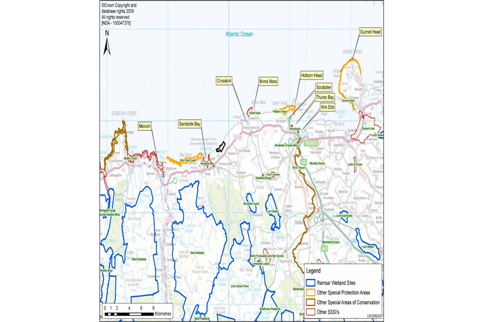
Map of area local to Dounreay