National Geological Screening Guidance
Published 21 April 2016

© Crown copyright 2016
This publication is licensed under the terms of the Open Government Licence v3.0 except where otherwise stated. To view this licence, visit nationalarchives.gov.uk/doc/open-government-licence/version/3 or write to the Information Policy Team, The National Archives, Kew, London TW9 4DU, or email: psi@nationalarchives.gov.uk.
Where we have identified any third party copyright information you will need to obtain permission from the copyright holders concerned.
This publication is available at https://www.gov.uk/government/publications/national-geological-screening-guidance/national-geological-screening-guidance
1 Introduction
1.1 It is internationally accepted that the safest option for managing higher activity radioactive waste in the long term is geological disposal: placing the solid waste deep underground in specially constructed facilities. The facilities contain multiple engineered barriers which work together with the geological environment to contain the radioactive material so that it does not cause harm to people or the environment. Some of the wastes will remain hazardous for hundreds of thousands of years and the geological environment has an important role in providing safety in the very long term. By placing the waste deep underground it will be protected in the event of earthquakes, tsunamis and environmental changes such as future ice ages.
1.2 National geological screening will present an overview of existing information about the geology to a depth of about 1000 metres or so beneath England, Wales and Northern Ireland. It will focus on aspects of the geological environment that are relevant to the long-term safety of a geological disposal facility (GDF). In particular, screening will set out the available information on the distribution of stable rocks with low groundwater flow in which a GDF could potentially be built. It will identify geological features which may influence the movement of groundwater from GDF depths to the surface environment. It will also provide information to help us judge the likely impact of future geological changes, such as sea level rise and future ice ages, and to understand the distribution of minerals, hydrocarbons and other resources which may affect the likelihood of future civilisations inadvertently drilling or mining their way into the waste.
1.3 To demonstrate the safety of a GDF we need to assess how each barrier performs individually and how they work together as a system. The results of those assessments, alongside international guidance, enable us to establish how the geological barrier contributes to long-term safety. By providing existing and relevant information at a national scale for the various regions across England, Wales and Northern Ireland we will have a national resource to help inform early discussions with communities about their potential suitability to host a GDF.
1.4 Whilst no national exercise will be able to definitively rule all areas as either suitable or unsuitable, it is possible that screening may lead to some areas being identified as unsuitable for hosting a GDF. Detailed local information will be considered as part of the discussions with communities during the siting process.
1.5 The national geological screening exercise has two parts. The first part involves developing Guidance which sets out how the information will be assembled and presented. The second part involves applying the Guidance.
1.6 We developed the national geological screening Guidance in a collaborative way, drawing on the experience from the geoscience community, overseas waste management organisations and wider interested parties. We have held more than twenty meetings across the UK to share our work and help shape our approach.
1.7 We submitted the draft Guidance [1] to an Independent Review Panel (IRP) established by the Geological Society. The IRP is a group of seven expert geologists from the UK and overseas. They were asked to assess whether the screening Guidance is technically sound; can be applied using existing geological information; and provides a basis for assessing the prospects for developing a long-term safety case in a range of geological settings to accommodate the UK inventory of higher activity waste.
1.8 The IRP provided us with written review comments and held a meeting with us in public in London to discuss their views, a record of which is available on YouTube. We revised the national geological screening Guidance in response to the IRP review and presented it for public consultation between 8th September and 4th December 2015. This Final Guidance incorporates changes in response to feedback from the consultation exercise.
1.9 In Section 2 of this document we provide background information about geological disposal. The Guidance is presented in Section 3. A glossary of terms is provided on our website.
1.10 We, as experts in the science and engineering of geological disposal, will work with the British Geological Survey (BGS), who hold much of the authoritative and existing information on British geology, to apply the Guidance and develop the outputs. We are developing Detailed Technical Instructions for the BGS to collate the existing information. The BGS will produce a series of Technical Information Reports (TIRs) and maps for each region. These will provide the geological basis for RWM to develop outputs describing the key characteristics of the geological environment and their relevance to safety in a way that will be accessible to a non-technical audience.
1.11 The application of the Guidance and the developed outputs will be reviewed by the IRP. The Committee on Radioactive Waste Management (CoRWM) will maintain their scrutiny role and provide independent advice to Government on the manner in which the national geological screening Guidance is applied.
2 Context
The wastes
2.1 The UK has accumulated radioactive waste from a range of activities including nuclear power generation, medicine, research and defence-related nuclear programmes. Most of the waste can be disposed of safely in facilities on the surface but a long-term solution is still needed for the most radioactive waste (higher activity waste) some of which will remain hazardous for hundreds of thousands of years. The UK’s higher activity waste is made up of:
- high level waste, which arises initially as a liquid during the reprocessing of spent nuclear fuel and is converted to a solid glass form in a process called vitrification
- intermediate level waste from a range of nuclear activities including the operation, maintenance and decommissioning of nuclear facilities and the reprocessing of spent nuclear fuel
- a small amount of low-level waste, which is not suitable for disposal at the existing facilities
2.2 For geological disposal we consider higher activity waste in two groups: high heat generating waste (high level waste) and low heat generating waste (intermediate and low level waste).
2.3 In planning for the long-term management of higher activity waste, we include some nuclear material that is not currently classified as waste but could become so in the future if it is deemed to have no further use. This nuclear material includes spent fuel from nuclear power stations, uranium and plutonium. We also make provision for the waste that would be generated from a new build programme.
Government policy
2.4 UK Government’s policy is that higher activity waste should be managed through geological disposal.
2.5 There is a large range of potentially suitable geological environments for geological disposal the UK. To identify potential sites where a GDF could be located, the UK Government favours an approach based on working with communities that are willing to participate in the siting process.
2.6 The framework for implementing geological disposal is set out in a White Paper published in 2014 [2]. The White Paper sets out a programme of work to be completed before formal discussions can begin. National geological screening is included in this programme.
2.7 Siting will begin when this programme of work is complete, which is expected to be in about one year’s time. A high-level programme showing the stages in implementation, the activities at each stage and indicative timescales is given in Figure 1.
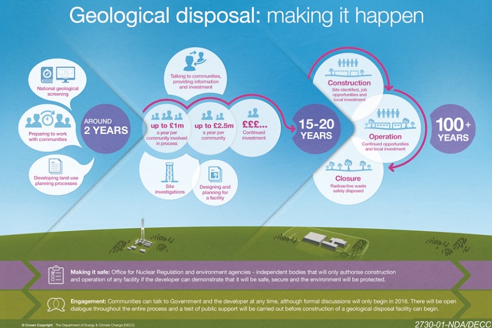
Figure 1. Geological disposal: making it happen
2.8 Radioactive waste management is a devolved policy issue. Therefore the Welsh Government, Northern Ireland Executive and Scottish Government each have responsibility for radioactive waste management in their areas. More information about these policies can be found in Appendix 1.
Geological disposal
2.9 Geological disposal involves placing waste deep underground to ensure that the hazardous materials are isolated from the surface environment and contained for the time required for the radioactivity associated with them to naturally reduce. This ensures that no harmful quantities of radioactivity ever reach the surface environment. There is general agreement internationally that geological disposal provides the safest long-term management solution for higher-activity waste.
2.10 The multiple barriers that provide safety for geological waste disposal are a combination of:
- the form of the radioactive waste itself
- the packaging of the waste, typically metal or concrete containers
- buffer or backfill materials placed immediately around the waste containers to protect them
- engineered features of the facility such as filled and sealed tunnels or vaults
- the stable geological environment in which the facility is sited
2.11 This is referred to as the multi-barrier system. The details of the barriers are tailored to the type of waste and the geological environment. Some examples are given in Figure 2.
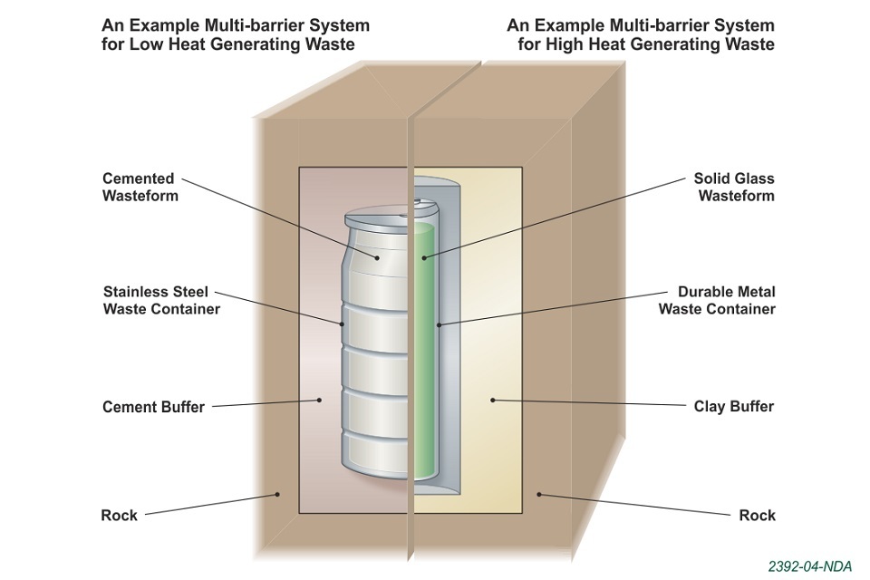
Figure 2. Schematic showing some examples of multi-barrier systems
What will a geological disposal facility look like?
2.12 A GDF will have both surface and underground facilities, linked by shafts or inclined tunnels, as illustrated in Figure 3. The surface facilities will comprise a number of buildings for waste receipt and transfer, infrastructure for the underground environment such as ventilation and administration and other support buildings. In total, they will cover an area of approximately 1sq km with the details of layout and appearance being tailored to the particular site.
2.13 The underground facilities will comprise a system of vaults and engineered tunnels for the disposal of waste. A GDF will be located at a depth between 200m and 1000m underground and will cover an area of approximately 10 to 20 sq km.

Figure 3. Artist's impression of a geological disposal facility
Demonstrating safety
2.14 The process for developing a GDF involves assessing its performance and demonstrating its compliance with all relevant safety requirements. The requirements cover construction of the GDF, all its operations and the long-term safety after the facility has been closed and sealed.
2.15 Geological screening is about long-term safety. The relevant requirements on the disposal system relating to long-term safety are set out in national and international standards and guidance [3] [4] [5]. These require that the multi-barrier system must provide:
-
isolation of radioactive waste
-
containment of radioactive waste
-
confidence in long term safety
-
low likelihood of future generations inadvertently intruding into a GDF
2.16 We need to assess how each barrier performs individually and how they work together as a system. We consider all the pathways by which radioactivity could be released from a GDF and return to the surface environment, through:
-
transport in groundwater that flows through the GDF
-
transport in gases generated by the waste
-
human intrusion into a GDF
2.17 We present the evidence from our assessment in a set of documents called a safety case. We have developed a generic safety case [6], where we describe how safety could be achieved in a range of different geological environments.
Approach to national geological screening
2.18 We used the evidence and understanding from our safety case to define long-term safety requirements to which the geological environment must contribute. We then identified the geological attributes which are relevant. The safety requirements and geological attributes are listed in the Guidance in Section 3. Appendix 2 describes the link between the safety requirements and the geological attributes in more detail.
3 National geological screening guidance
Introduction
3.1 National geological screening is an exercise to bring together existing information about aspects of geology that are relevant to the long-term safety of a GDF and make it available in an accessible form. It will provide authoritative information for England, Wales and Northern Ireland that can be used in early discussions with communities about their geological potential to host a GDF.
3.2 As required by the 2014 White Paper, the approach to national geological screening is based on geological attributes (characteristics of the geological environment relevant to the long-term safety of a GDF) and the requirements of the existing GDF safety cases.
3.3 The national geological screening Guidance comprises:
-
the safety requirements to which the geological environment contributes
-
geological attributes that are relevant to meeting these safety requirements
-
sources of existing geological information relevant to understanding these attributes
-
a description of the outputs that will be produced based on this existing geological information
Safety requirements
3.4 The first consideration in developing national geological screening Guidance is the contribution to long-term safety required from the geological environment, as a component of a multi-barrier system.
3.5 To understand the contribution to long-term safety of the geological environment we considered national and international standards and guidance and our generic safety case. The long-term safety requirements are listed in Table 1.
Table 1. The geological environment contributes to the following long-term safety requirements:
- the functions of the engineered barrier system will be maintained
- radionuclides or toxic substances entering groundwater will not compromise safety
- any gas generated in the GDF will not compromise safety
- natural events and changes will not compromise safety
- the site can be characterised sufficiently to demonstrate safety
- the effect of long-term evolution on safety can be understood
- the likelihood of human intrusion can be assessed
Geological attributes
3.6 We identified geological attributes that are relevant to meeting the safety requirements under five geological topics: rock type, rock structure, groundwater, natural processes and resources. The geological attributes are listed in Table 2 and you can find information on how they relate to the safety requirements in Appendix 2.
Table 2. Geological attributes
| Rock type | distribution of potential host rock types (higher strength rocks, lower strength sedimentary rocks, evaporite rocks) at the depths of a GDF |
| properties of rock formations that surround the host rocks | |
| Rock structure | locations of highly folded zones |
| locations of major faults | |
| Groundwater | presence of aquifers |
| presence of geological features and rock types which may indicate separation of shallow and deep groundwater systems | |
| locations of features likely to permit rapid flow of deep groundwater to near-surface environments | |
| groundwater age and chemical composition | |
| Natural processes | distribution and patterns of seismicity |
| extent of past glaciations | |
| Resources | locations of existing deep mines |
| locations of intensely deep-drilled areas | |
| potential for future exploration or exploitation of resources |
Screening approach
3.7 National geological screening will be carried out for England, Wales and Northern Ireland but will not be applied to Scotland (which has a different higher activity waste management policy).
3.8 Our approach will provide information relating to geological attributes at a regional scale and we will indicate the prospects for long-term safety. In some areas, we expect to find that very little is known about the geological environment at the depths we are interested in. Although numerical assessments will be important later in implementation when we consider the characteristics of specific sites and are developing site-specific designs, they are not appropriate at this stage in the process.
3.9 We will apply the Guidance working closely with the BGS and specialist contractors. We have developed detailed technical instructions, setting out specifically how to capture information about the attributes from the available datasets. These detailed technical instructions have been reviewed by the IRP.
3.10 The relevant geological information will be sourced from publicly available national datasets and compilations. We recognise that there is more detailed information available for particular areas and/or for particular geological attributes and where appropriate this information will be considered later in the siting process.
3.11 The depth of the underground facilities of a GDF is expected to be between 200m and 1000m. The surface facilities of a GDF will be located on land. However the design of a GDF could allow the underground facilities to extend offshore if accessed from onshore surface facilities. Therefore screening will consider the geological environment in England, Wales and Northern Ireland, including areas up to 20km offshore.
3.12 The approach to assembling information about the geological attributes and the information sources to be used are presented in the following sub-sections for each geological topic. Table 3 on Page 19 summarises the principal information sources.
Rock type
3.13 We will produce maps to show the distribution of potentially suitable host rocks across England, Wales and Northern Ireland in the depth range 200m to 1000m.
3.14 The surrounding geological environment and its expected contribution to safety will be discussed in a narrative.
3.15 Low potential for groundwater flow is one of the main factors used in identifying potentially suitable host rocks. Building on the approach described in the 2010 generic Disposal System Safety Case [6], potentially suitable host rocks will be considered in three broad types, based on UK geology and environments that have been identified internationally as suitable for geological disposal. These types are classified as higher strength rocks, lower strength sedimentary rocks and evaporite rocks:
-
higher strength rocks, which may be igneous, metamorphic or older sedimentary rocks, have a low matrix porosity and low permeability, with the majority of any groundwater movement confined to fractures within the rock mass
-
lower strength sedimentary rocks are fine-grained, sedimentary rocks with a high content of clay minerals that provides their low permeability and are mechanically weak, so that open fractures cannot be sustained. They will be interlayered with other sedimentary rock types
-
evaporite rocks have formed as ancient seas and lakes evaporated and often contain bodies of halite that provide a suitably dry environment and are weak and creep easily so that open cracks cannot be sustained.
3.16 We will use geological columns for each region to identify which of the rock units shown on existing BGS geological maps, cross sections and three-dimensional models are likely to contain each of the potential host rock types. This assignment will consider existing qualitative information such as the BGS Permeability Index and experience from exploitation of water and other resources in the same or similar geological formations in the UK and Europe. The reasons for allocating rock units to particular host types will be documented and uncertainties in rock properties that would need to be resolved by further investigations during the siting process will be discussed in the narratives.
3.17 The principal information sources will be the BGS maps, memoirs and stratigraphic summaries, together with the BGS UK3D model.
3.18 The UK Government has a strong preference to manage the inventory for disposal in one GDF and recognises that this would require a large enough volume of suitable rock (in an area willing to host a GDF) for the underground facilities to be constructed and for a safety case made. However as a single GDF is not a requirement, volumes of rock that would be suitable for only a part of the inventory will also be included at screening. The minimum rock volume of interest as a potential host rock has an area of the order of one square kilometre and a thickness of some tens of metres. The volume of host rock at a particular location would be considered in more detail during the siting process.
3.19 Although the near-surface geology of the UK is well known, the uncertainty increases at greater depth, except in specific areas such as those that have been exploited or explored for deep geological resources. In particular, depth and thickness estimates may be subject to significant uncertainties at increasing distances from existing boreholes. Additionally, the nature of concealed rock units that are only imaged by geophysics may only be understood in general terms. In the depth range of interest, as a general guide, we can make the following points:
-
for concealed higher strength rocks, it is likely that only their presence and approximate depth are known; the exact nature of the rocks present may be quite poorly defined
-
for layered sedimentary rocks, the exact depths and thicknesses of known layers may be uncertain. It may be known that specific layers are not persistent or that the mapped formations vary in composition, however, where these changes take place may not be well known
-
it is generally possible to identify the formations that include evaporite rocks, but it will not be possible to specify which evaporite rocks (such as halite) are present.
3.20 These uncertainties will be made clear in regional narrative descriptions.
Rock structure
3.21 We will produce maps to show:
-
locations of major faults and fracture zones
-
locations of highly folded zones
Many of these structural features are well-known and are identified in the BGS regional guides and memoirs. They are relevant to safety in two ways. Firstly they may provide effective limits to any rock volume being considered for siting a GDF. Secondly they have an impact on the uniformity and predictability of rocks and groundwater at a scale of relevance to a GDF.
3.22 The principal sources of information will be the BGS 1:1,500,000 “Tectonic map of Britain, Ireland and adjacent areas” and the BGS 1:1,000,000 map and contour overlay “Pre-Permian geology of the United Kingdom (South)”. 1:50,000 BGS solid geology maps and supporting memoirs contain further information which may be useful in identifying which of these complex zones have characteristics which are of relevance to the safety requirements for a GDF.
Groundwater
3.23 Consideration of groundwater in screening is limited by the lack of national information available about the movement and chemical composition of groundwater in the depth range of a GDF. There is very little information available from below those aquifers that are currently exploited for groundwater. Furthermore, groundwater movement and composition can vary significantly over short lateral and vertical distances. Developing an understanding of groundwater movement and chemistry and the implications for safety are major activities which will be carried out during the siting process and particularly during site characterisation.
3.24 Therefore we will produce maps showing locations of features which may indicate connectivity between deep and near-surface groundwater:
-
deep-sourced springs
-
existing deep mine workings
-
arrays of deep exploration boreholes extending to depths in excess of 200m.
3.25 The following information will be discussed in regional narratives:
-
potable aquifers, identified from maps of the distribution of aquifers in England, Wales and Northern Ireland [7]. Where deep salinity data are not available, a maximum depth of 400m for potable water will be assumed [8]
-
the distribution of deeper confined aquifers, identified from the BGS UK3D model
-
the location of deep-sourced springs and the potential presence of karst at depths great than 200m
-
the presence of rock types and other geological features likely to result in separation of deep and shallow groundwater bodies, for example the presence of lower-strength sedimentary or evaporite rocks
-
the limited regional information about groundwater chemistry, salinity and age, sourced mainly from the existing BGS/Environment Agency (EA) baseline chemistry and dominant geochemical processes reports [9]. This information can be useful for indicating groundwater movement and residence time
-
areas of elevated topography, which may have an influence on regional groundwater flow.
Natural processes
3.26 We will provide a qualitative explanation of the nature and distribution of natural processes that have the potential to affect safety. This will include a commentary on the UK’s history of seismicity with an explanation of the amounts and depth of observed fault movements. It will also consider the UK’s possible future climate, including both ice ages and the possibility of sea level rise from global warming. We will also discuss the uncertainties in projections of future events from historical information. Many aspects of this topic were recently investigated and reported in BGS Commissioned Report, Potential Natural Changes and Implications for a UK GDF [10]. Therefore we plan to use this report as the principal information source for screening. The regional narratives will highlight the relevance of this information in the regional context.
3.27 Because of the scale on which natural processes operate, these outputs will be presented as national maps. It is proposed to produce a national map of the distribution of recent seismicity and a national map showing the extent of past glaciation.
Resources
3.28 We will produce maps of the locations of known reserves of a range of metal ores, industrial minerals, coal and hydrocarbons below a depth of 100m that are exploited today or have been exploited in the past. Shallower resources that clearly have no deeper extension, such as sand, gravel or peat, will not be considered because they are above any possible GDF.
3.29 Future exploration often takes place at sites where shallower mining has taken place in the past, with a view to finding deeper reserves, and for this reason mining below 100m is considered relevant. Resources below 1000m are included because the GDF might be intersected by drilling or extraction.
3.30 We will discuss in the narrative the possible extent of remaining resources of materials beyond the limits of existing or planned workings (e.g. coal) and provide information on other potentially exploitable resources whose presence can reasonably be inferred. This will include the potential for coal-bed methane, shale gas, gas storage and geothermal energy. Evaluating the likely potential for future deep exploration is subjective and uncertain because it will depend on market conditions as well as geological information.
3.31 The primary sources of information will be compilations of information about past mining operations in the UK, particularly the BGS maps “1:1500,000 Coal Resources (1999)” and “1:1500,000 Metallogenic Map (1996)” together with the BGS Economic Geology Memoir series. Information about current operations will be taken from the BGS BRITPITS dataset, which includes the BGS Directory of Mines and Quarries. The BGS GeoIndex includes a large database of onshore boreholes that can be filtered by depth; this may provide supporting information for identifying locations where the resources have already been exploited and enables identification of arrays of multiple deep boreholes.
Table 3. Principal information sources
| Topic | Principal information sources |
|---|---|
| Rock type | BGS maps, memoirs and stratigraphic summaries |
| BGS UK3D model | |
| Rock structure | BGS 1:1,500,000 “Tectonic map of Britain, Ireland and adjacent areas” |
| BGS 1:1,000,000 map and contour overlay “Pre-Permian geology of the United Kingdom (South)” | |
| 1:50,000 BGS solid geology maps and supporting memoirs | |
| Groundwater | Information gathered under Rock Type and Rock Structure topics |
| Information gathered under Resources about existing deep mines and onshore boreholes | |
| Maps of the distribution of aquifers in England, Wales and Northern Ireland | |
| BGS/EA baseline chemistry and dominant geochemical processes report series | |
| Natural processes | British Geological Survey, National Nuclear Laboratory, University of Manchester Dalton Nuclear Institute, Potential Natural Changes and Implications for a UK GDF. Minerals and Waste Programme Commissioned Report CR/12/127. 2012 |
| British Geological Survey, Regional modelling of the potential for permafrost development in Great Britain. Minerals and Waste Programme Commissioned Report CR/14/023 73. 2014 | |
| Resources | BGS 1:1500,000 Coal Resources map |
| DECC published information on conventional and unconventional hydrocarbons | |
| BGS 1:1500,000 Metallogenic Map (1996) | |
| BGS County Mineral Resource maps and reports | |
| BGS Economic Geology Memoir series | |
| BGS BRITPITS dataset | |
| BGS GeoIndex, NIINDEX and Off-shore Borehole Database for information on onshore and offshore boreholes | |
| BGS Geothermal Prospectivity Map |
Form of outputs
3.32 The outputs of geological screening are designed to help communities who wish to engage with us about their potential to host a GDF. Feedback gathered during the development of the Guidance indicated a desire to have short documents that summarise the key points and are accessible to a non-specialist audience. We also recognise that some members of these communities would like access to more detailed information.
3.33 Therefore we will present the outputs of screening as a series of brief narratives describing the key characteristics of the geological environment of the region and their relevance to safety. The narratives will be illustrated with maps, where appropriate.
3.34 We will produce packages of outputs for each geological region of England, Wales and Northern Ireland. The geological regions will be those used by the BGS in its Regional Guides (shown in Figure 4). The Regional Guide publication series provides a structure for which there is a well-established source of more detailed information for those who would like to know more.
3.35 For some attributes information will be presented at a national level only, because data are very sparse or vary little across all regions, and so there will also be a short national output presenting this information, which is applicable to all regions.
3.36 The outputs will be provided in a tiered manner such that the more technical supporting information on which they are based and the records of the decisions taken in compiling and presenting the outputs will also be made available.
3.37 The maps will be developed nationally at a scale of 1:625,000 (approximately 1 inch to 10 miles) and presented as regional maps with an appropriate Ordnance Survey overlay showing major towns and cities. Each map will overlap adjacent regions for the benefit of people living near the boundaries. The maps and the narratives will also outline the uncertainty associated with the information and give a high level indication of the investigation techniques which could be employed in the future to address that uncertainty.
3.38 We will consider a range of media, such as talking head videos, documentaries or GIS format, for making the outputs accessible to the full range of stakeholders and test these during their development.
3.39 A summary of the outputs for each geological topic is presented in Table 4.

Figure 4. British Geological Survey regions
Table 4. Summary of outputs
| Rock Type | Narrative | Maps (1:625,000) |
|---|---|---|
| Geological topic | Description of the potential host rocks, their depths and remaining uncertainties in properties and/or location. Description of rock formations surrounding potential host rocks with properties that may contribute to safety. The rock type descriptions will be illustrated with a geological column showing the sequence of rocks present in the region. | Regional maps of distribution of potential host rocks at 200-1000m depth (separate maps for the distribution of each of the three generic host rock types). Summary regional maps of areas beneath which at least one potential host rock may be present. |
| Rock Structure | Explanation of the nature of the structures within the region that are relevant to safety. These will be major faults and fault zones and areas of folded rocks with complex properties. | Regional maps of the distribution of the structures described in the narrative. |
| Groundwater | Explanation of the known shallow and deep groundwater flow regimes and groundwater chemistry, salinity and age. Discussion of the rock types and other geological features likely to influence groundwater movement and the interaction between deep and shallow groundwater in the region. | Regional maps of areas showing locations of deep boreholes, mines and thermal springs. |
| Natural Processes | Interpretation of national information (on seismicity, uplift rate, erosion rate, and past ice cover during glaciations) in the context of the region. | National map of the distribution of recent seismicity. National map showing the extent of past glaciation. |
| Resources | Description of the past history of deep resource exploration and exploitation with a discussion of the potential for future exploitation of resources in the region. | Regional maps of historic and contemporary exploitation of metal ores, industrial minerals, coal and hydrocarbons at >100m depths. |
Appendix 1. Devolved Administration positions
A1.1 Radioactive waste management is a devolved matter. Therefore, the Welsh Government, Northern Ireland Executive and Scottish Government each have responsibility for this issue in or as regards Wales, Northern Ireland and Scotland respectively. Their respective policy positions are summarised below.
A1.2 The 2014 Implementing Geological Disposal White Paper was issued jointly by the UK Government and the Northern Ireland Executive. It confirms the policy of geological disposal for higher activity radioactive waste including a voluntarist approach to the siting process for a GDF that is based on the willingness of local communities to participate.
A1.3 The Northern Ireland Executive has responsibility for ensuring that any proposed GDF will not have an adverse impact upon the environment, health or safety of Northern Ireland. Northern Ireland continues to support the implementation of geological disposal for the UK’s higher activity radioactive waste, recognising that it is in the best interests of Northern Ireland that these wastes are managed in the safest and most secure manner.
A1.4 The Scottish Government is not a sponsor of the programme for implementing geological disposal, but does remain committed to dealing responsibly with radioactive waste arising in Scotland. On 20 January 2011, the Scottish Government published Scotland’s Higher Activity Waste Policy. Scottish Government policy is that the long-term management of higher activity radioactive waste should be in near-surface facilities. Facilities should be located as near to the sites where the waste is produced as possible. While the Scottish Government does not support deep geological disposal, it continues, along with the UK Government and other devolved administrations, to support a robust programme of interim storage and an ongoing programme of research and development.
A1.5 The Welsh Government has adopted a policy for geological disposal for the long-term, safe and secure management of higher activity radioactive waste [11]. The Welsh Government considers that a GDF will only be deliverable in Wales on the basis of a voluntary partnership with interested local communities willing to enter into discussions about potentially hosting a GDF and the successful conclusion of those discussions.
A1.6 The Welsh Government has undertaken a consultation on Community Engagement and Implementation Processes [12] to seek views on the processes by which a GDF might be sited in Wales, and to provide information to potential volunteer host communities which may want to enter discussions, without commitment, about hosting a geological disposal facility.
Appendix 2. Geological attributes and their relevance to safety
Introduction
A2.1 Geological attributes are characteristics of the geological environment that are relevant to the long-term safety requirements listed in Table 1 of Section 3 in the main document. They may be characteristics of either the rock or the groundwater or may relate to geological processes or events.
A2.2 It is necessary to consider all the geological attributes in a given location, the degree to which they are present or absent, the ways in which they may interact with each other, and the extent to which the geological attributes and the engineered components of the multi-barrier system may complement each other to ensure overall safety.
A2.3 Geological attributes are discussed below within five topics selected to encompass the characteristics of the geological environment:
- rock type
- rock structure
- groundwater
- natural processes
- resources
A2.4 Experts from the BGS and other specialist geological contractors (for example in structural geology, geophysics, rock mechanics and hydrogeochemistry) supported RWM in identifying and describing the geological attributes.
A2.5 The five topics are used to structure a description of the relevant geological attributes which are described in more detail in each of the following sub-sections. A brief description of the topic is presented, its relevance to safety is described and a list of the geological attributes is presented.
Rock type
Description
A2.6 Rock type attributes relate to the nature and properties of the rocks present in the subsurface, including the characteristics of potential host rocks in the appropriate depth range and those of surrounding rocks that could contribute to the safety of a GDF.
A2.7 Low groundwater flow is one of the main factors used in identifying potential host rocks. Potential host rocks have been considered in three broad types, based on UK geology and environments that have been identified internationally as suitable for geological disposal. These types are classified as higher strength rocks, lower strength sedimentary rocks and evaporite rocks:
- higher strength rocks, which may be igneous, metamorphic or older sedimentary rocks, have a low matrix porosity and low permeability, with the majority of any groundwater movement confined to fractures within the rock mass.
- lower strength sedimentary rocks are fine-grained, sedimentary rocks with a high content of clay minerals that provides their low permeability and are mechanically weak, so that open fractures cannot be sustained. They will be interlayered with other sedimentary rock types.
- evaporite rocks have formed as ancient seas and lakes evaporated and often contain bodies of halite that provide a suitably dry environment and are weak and creep easily so that open cracks cannot be sustained.
Relevance to safety
A2.8 Rock type makes an important contribution to several safety requirements.
A2.9 The host rock must provide an environment with properties that permit the functions of the engineered barrier system to be maintained. The host rocks and the surrounding rocks together must contribute to providing an environment in which harmful quantities of radionuclides or toxic substances will not reach the surface environment by movement in groundwater or in gases generated within the GDF. They must also control the release of any gas generated in the facility to avoid any damage being caused to the containment properties of the multi-barrier system.
A2.10 Rock type also affects the ability to characterise the geological environment sufficiently and to understand its response to natural events and changes.
A2.11 A potential host rock must be located at sufficient depth to ensure that the waste is isolated from the surface environment. It must have sufficient extent in all dimensions to accommodate the GDF and provide an envelope of rock around the GDF with thermal, hydrogeological, mechanical and chemical properties that support safety.
A2.12 For higher strength rock to be a potential host rock for a GDF it would need to occur in a rock body that exhibits reasonably uniform and predictable properties, including fracture permeability, on the scale of the intended GDF. The way in which water moves through the rock in the networks of partly connected fractures that characterise these strong formations would be an important factor in deciding their suitability. Safe disposal of radioactive waste requires a geological environment where groundwater in the vicinity of the GDF cannot readily interact with shallow groundwater.
A2.13 For a lower strength sedimentary rock to be a potential host rock, it would be rich in clay minerals and would be of sufficiently low permeability that any movement of radionuclides through the formation would be dominated by diffusion.
A2.14 For an evaporite rock to be a potential host rock, any fractures that form would need to reseal, preventing ingress of water. Evaporite bodies that are particularly rich in halite would be suitable host rocks for a GDF, provided they were present on an appropriate scale.
A2.15 The rocks that surround the host rock may also contribute to safety. Surrounding rocks with low permeability may prevent the groundwater in the rock bodies beneath them from mixing with groundwater in the rocks above. This is one way in which the rock volume containing a GDF can be effectively hydraulically separated from shallower groundwater systems, preventing harmful quantities of radionuclides or toxic substances reaching the surface environment. In particular the rocks surrounding a higher strength rock which is fractured may make an important contribution in this respect.
A2.16 The presence of specific rock-forming minerals may also influence long-term safety. Some minerals (such as clay minerals and iron oxides) are particularly effective at removing radionuclides from groundwater by sorption or precipitation. These minerals may not be present in large percentages by volume, but frequently occur as coatings on the surfaces of the fractures that contain groundwater in higher strength rocks.
A2.17 Mineralogy also influences the groundwater chemistry and the deep microbiological environment, which are important considerations in maintaining the functions of the engineered barriers.
Rock type attributes:
- distribution of potential host rock types (higher strength rocks, lower strength sedimentary rocks, evaporite rocks) at the depths of a GDF
- properties of rock formations that surround the host rocks
Rock structure
Description
A2.18 Rock Structure attributes relate to the three-dimensional form and arrangement of different rocks, particularly the presence of geological features at depth, such as folding, faults and highly-fractured zones, which will distort or disrupt the rock mass.
Relevance to safety
A2.19 Rock structure is principally of relevance to the requirements to characterise a site sufficiently to demonstrate safety and to understand the effect of long-term evolution on safety. The ability to characterise a rock mass will depend on the rock structure and its degree of complexity and this in turn will impact on the ability to understand rock types, groundwater conditions and fracture properties in the subsurface. It is also relevant to providing a geological environment in which harmful quantities of radionuclides or toxic substances will not reach the surface environment.
A2.20 There are some specific rock structures in which a diverse range of rock types with contrasting physical properties are closely juxtaposed across steeply dipping contacts. These zones would be unfavourable for GDF development as there could be upwards groundwater flow across layering through cracks that separate rocks of different properties or across fault planes. Some examples comprise folded sedimentary sequences but others are major faults that juxtapose a range of rock types. Highly folded zones and multiple major faults can form zones hundreds of metres to a few kilometres across but extending for tens of kilometres in length. Such zones contain a dense arrangement of diverse rock types in which their physical properties are difficult to characterise and commonly have complex patterns of groundwater flow.
A2.21 In contrast, where rocks have undergone intense folding or shearing under elevated temperatures, rock properties are typically more uniform throughout. These rocks may prove to be homogeneous in the context of groundwater flow and their deformation would not affect the long-term safety of a GDF.
A2.22 Furthermore, whilst individual faults do not necessarily compromise safe disposal of radioactive wastes, they need to be considered. Deep groundwater movement may still be predictable around large faults but the deep groundwater regime may change across them and this also needs to be considered during siting. Faults can act as pathways for flow or as barriers to it, which is why generalisation is not possible.
Rock structure attributes:
- locations of highly folded zones
- locations of major faults
Groundwater
Description
A2.23 Groundwater attributes relate to the movement and chemical composition of groundwater present in pores and fractures in rocks from surface to a depth of around 1000m. Groundwater saturates the pores and fractures in the majority of UK rocks below a few tens of metres depth and, where these pores and fractures are interconnected, water can move through the rock formations.
A2.24 Groundwater moves differently depending on the type of host and surrounding rocks, and consequently radionuclides contained within the groundwater will behave differently.
Relevance to safety
A2.25 The movement of groundwater is relevant to providing a geological environment in which harmful quantities of radionuclides or toxic substances will not reach the surface environment. Radionuclides and other toxic materials can be transported in groundwater from GDF depths to the surface environment. This transport is influenced by the volume of water present in the rocks and its rate of movement.
A2.26 Knowledge of groundwater movement is relevant to characterising a site sufficiently to demonstrate safety.
A2.27 Groundwater is also relevant to the requirement that any gas generated in the GDF will not compromise safety. The movement of radionuclides in gases, or gases dissolved in groundwater, must not result in harmful quantities of radionuclides or toxic substances reaching the surface environment. The ingress of groundwater into a GDF also contributes to the reactions that drive the generation of gas, and thus the limitation of groundwater ingress is important.
A2.28 Rapid groundwater movement additionally has the potential to affect the function of the engineered barrier system, for example by physically eroding materials such as the backfill or buffer.
A2.29 Groundwater chemistry is relevant to understanding how the geological environment will affect engineered barrier materials and hence ensuring that the functions of the engineered barrier system are maintained.
A2.30 Groundwater chemistry also allows old and deep, saline groundwater systems that do not interact with shallow, potable groundwater to be identified and so provides additional evidence of low or no groundwater movement.
A2.31 Favourable conditions with respect to groundwater movement are those in which any groundwater movement in the potential host rock is slow, and is likely to remain so in the future. Effective hydraulic separation of deep and shallow groundwater systems is also favourable. This is the case where deep groundwater does not readily mix with the shallow groundwater systems, thus providing limited interaction with the surface environment; this may arise through a combination of geological features and the presence of denser groundwater at depth.
A2.32 Rock sequences that include layers of low permeability rock often contain an isolated deep groundwater system separated from shallower groundwater systems, characterised by different geochemical compositions. In the absence of a distinct impermeable layer, the contrast between a low permeability rock at depth containing limited amounts of dense groundwater, and shallower, permeable beds with fresh groundwater can also result in effective hydraulic separation.
A2.33 Favourable conditions with respect to groundwater chemistry are compositions whose reactivity towards materials in the engineered barriers does not compromise their contribution to safety and whose compositions are unlikely to change as a result of influx of water from different sources.
A2.34 Some geological features can serve as pathways leading to rapid return of deep groundwater to the surface environment and where this occurs such conditions are not favourable for geological disposal. An example is the presence at surface of thermal springs, usually indicative of groundwater movement from a significant depth (at least 200m and often over 1000m) back to surface. Even in the absence of thermal anomalies such as warm springs, rock volumes that contain extensive interconnected voids (such as natural karstic limestone or old mining districts) also have the potential for rapid and unpredictable groundwater movement connecting deep groundwater with shallow systems, and are unfavourable.
A2.35 Aquifers are rocks that contain freshwater in pores and/or fractures and whose porosity and permeability are sufficiently high to make the abstraction of groundwater feasible. They would not be suitable host rocks for a GDF. However, the rock underlying an aquifer may be suitable, provided there is adequate separation of the groundwater regime.
Groundwater attributes:
- presence of aquifers
- presence of geological features and rock types which may indicate separation of shallow and deep groundwater systems
- locations of features likely to permit rapid flow of deep groundwater to near-surface environments
- groundwater age and chemical composition
Natural processes
Description
A2.36 Natural processes attributes relate to our understanding of how the geological environment would respond in the event of sea level change, erosion, earthquakes, regional uplift or the growth and retreat of ice sheets and glaciers.
Relevance to safety
A2.37 A number of natural processes are relevant to maintaining the safety of a GDF over very long timescales. Examples of such processes are sea-level change, erosion, earthquakes, regional uplift and the growth and retreat of ice sheets and glaciers. Such processes are influenced by tectonic stress and by long-term climatic drivers.
A2.38 A change in sea level has the potential to influence groundwater movement around a GDF, particularly if the site has a coastal location.
A2.39 Erosion of the land surface by rainfall and river incision would result in a reduced thickness of the geological barrier around a GDF and mainly takes place in areas where there is regional tectonic uplift. Conversely, in areas of regional tectonic subsidence, sedimentation results in a thicker geological barrier over time.
A2.40 During glacial episodes, the formation and decay of permafrost, glaciers and ice sheets drive enhanced erosion and influence the chemical composition and movement of deep groundwater. The development of permafrost affects the patterns and rates of water movement in the subsurface, as well as water composition, while the growth of ice sheets increases hydraulic head beneath the ice, potentially moving fresh groundwater to greater depths and setting up new flow patterns. However, in lower permeability environments the hydraulic effects of glaciation may be to lock in beneficial downward hydraulic gradients for long periods of time after the glaciers have retreated, effectively isolating shallow and deep groundwater systems.
A2.41 Earthquakes (seismicity) result from the release of energy associated with sudden movement along existing faults, or (very rarely) the propagation of new faults. Faults may also move without earthquakes (aseismic creep). Most earthquake risk to engineered structures occurs at Earth’s surface, from shaking due to the propagation of surface waves. Shaking is strongly attenuated at GDF depths and deep underground structures suffer little from shaking damage, even in major seismic events. Significant fault movement in the vicinity of a GDF could physically damage the engineered barrier system if it results in centimetre-scale displacements in a network of small fractures in the GDF host rock. Mapped faults would be avoided in laying out the openings of a GDF, making it unlikely that individual vaults or tunnels would be directly cut by any future movement on old faults.
A2.42 Favourable conditions with respect to natural processes are those where the anticipated natural processes are sufficiently slow and are adequately understood so that their consequences can be shown not to compromise the safety of the multi-barrier system.
Natural processes attributes:
- distribution and patterns of seismicity
- extent of past glaciations
Resources
Description
A2.43 Resources attributes relate to geological resources present or suspected to be present at depth. It covers both deep-mined or intensely drilled areas and the presence of potentially exploitable resources (coal, hydrocarbons including unconventional resources, metal ores and industrial minerals). Many resources that have been exploited in the past are considered relevant because most exploration for new resources often takes place around sites of past exploitation.
A2.44 Resources have been defined for the purposes of national geological screening as unusually enhanced concentrations at depth of a specific element, mineral, liquid, gas or heat, which might reasonably be of value in the future and which cannot be sourced from locations closer to the surface. This definition includes resources that have not been shown to be economically viable, such as shale gas, coal-bed methane and geothermal resources, as well as possible extensions of reserves that are exploited today or have been exploited in the past.
A2.45 Aquifers, a water resource, have been discussed under the Groundwater topic.
Relevance to safety
A2.46 Resources are relevant to the requirement to provide an environment in which the potential consequences of human intrusion can be assessed and any practical measures implemented to reduce the likelihood. Deep-mined or intensely drilled areas are relevant to GDF safety because a future society, unaware of the presence and purpose of a GDF and seeking new resources in the vicinity of those exploited in the past, may unwittingly drill or mine the area in which it is situated. Intrusion by people, including mining and drilling, could affect the geological environment and the function of the multi-barrier system.
A2.47 Information about past and current deep mining and drilling also supports understanding of groundwater movement because of the impact that the excavations may have on groundwater movement patterns.
Resources attributes:
- locations of existing deep mines
- locations of intensely deep-drilled areas
- potential for future exploration or exploitation of resources ## References
*[CoRWM] Committee on Radioactive Waste Management *[DECC]: Department of Energy and Climate Change *[GDF]: Geological Disposal Facility *[GIS]: Geographic Information System *[IRP]: Independent Review Panel *[TIRs]: Technical Information Reports