Medway Estuary and Swale flood and coastal risk management strategy
Updated 11 November 2025

© Crown copyright 2025
This publication is licensed under the terms of the Open Government Licence v3.0 except where otherwise stated. To view this licence, visit nationalarchives.gov.uk/doc/open-government-licence/version/3 or write to the Information Policy Team, The National Archives, Kew, London TW9 4DU, or email: psi@nationalarchives.gov.uk.
Where we have identified any third party copyright information you will need to obtain permission from the copyright holders concerned.
This publication is available at https://www.gov.uk/government/publications/medway-estuary-and-swale-flood-and-coastal-risk-management-strategy/medway-estuary-and-swale-flood-and-coastal-risk-management-strategy
Introduction
In 2019, Defra approved the Environment Agency’s Medway Estuary and Swale (MEAS) Flood and Coastal Erosion Risk Management (FCERM) strategy.
The strategy sets out the Environment Agency’s plan to sustainably manage the coastline and tidal defences in the Medway estuary and Swale area. It aims to protect people, properties, designated habitat and agricultural land over the next 100 years.
We worked with a wide variety of interested parties to develop the strategy. We considered the best economic, environmental and technically appropriate approaches to manage flood and coastal erosion risk.
The strategy describes the best solutions for managing flood risk. It also considers the:
- impacts and benefits for communities
- environment
- cost to the taxpayer
Current work: the Medway Estuary and Swale 10-year programme
The Environment Agency has begun a 10-year programme of work to carry out the recommendations of the MEAS strategy.
The programme includes:
- 12 schemes to refurbish and/or raise existing flood defences
- 6 schemes to realign defences and create compensatory intertidal habitat - this will replace what is lost because of sea level rise
- the creation of freshwater habitat this will maintain the integrity of the designated sites, whilst allowing coastal adaptation
- sustainable asset management decisions - where we cannot justify spending public money we will look at where we can adapt or hand over maintenance of flood defences to other parties
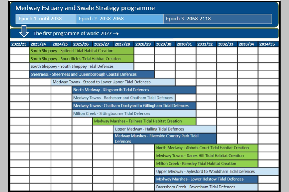
An indicative programme of the 18 schemes
The schemes depend on the availability of funding from:
- government
- beneficiaries
- partner organisations
Taking a programme approach across 10 years offers many opportunities.
They include:
- efficient delivery - there are significant interdependencies so we have a single business case to develop the MEAS programme - this saves us significant time and money by allowing us to do many activities once and coordinate our plans
- consistency - the size of the programme lets us work consistently with all stakeholders to create an integrated and sustainable coastline
- integrating sustainable development - the timescale of the programme gives us time to make the most of future opportunities such as riverside development and regeneration plans
- attracting further investment - the value of the programme means we will be able to access more opportunities for local and national funding sources, alongside FCERM Grant in Aid (FCERM GiA) funding
The first set of schemes being carried out are the:
- Elmley and South Sheppey scheme - which includes the Spitend tidal habitat creation, Roundfields tidal habitat creation and South Sheppey tidal defences
- Sheerness and Queenborough scheme
Background: The Medway Estuary and Swale Strategy
The Medway Estuary and Swale lies on the northern edge of the Kent coastline. Many areas around the Medway estuary and Swale are low-lying and at significant risk of flooding.
Over the next 100 years this risk will increase due to:
- ageing flood defences - much of the existing flood defence network was built between the 1950’s and 1970’s
- rising sea levels and climate change - the area has already experienced more than 10cm of sea level rise since 1990, which is significantly increasing the likelihood of flooding
As a result there will be a greater risk of tidal flooding for:
- approximately 18,000 properties
- more than 10,000 hectares of agricultural land
- important infrastructure
Much of the Medway Estuary and Swale is covered by national and international designations that protect important species and habitats. These include:
- Special Protection Areas (SPA)
- Ramsar
- Sites of Special Scientific Interest (SSSI)
- Marine Conservation Zone (MCZ)
- individually protected rare and endangered species of plants and animals
As sea levels rise, some of this important habitat will be lost as it is ‘squeezed’ against the existing flood defences. The MEAS strategy include actions to create new intertidal areas. These will replace lost habitats and make sure the area’s nature can continue to thrive.
We developed the Strategy and carried out a wide range of studies. These helped us to understand the likely impacts of climate change and sea level rise on:
- the existing flood defences
- the flood risk to communities and infrastructure
- internationally important habitat and other land
We considered this over the short, medium and long-terms.
We measured the economic value of areas at flood risk against the costs of protecting it in the future. We then used this to determine the most sustainable policy for each section of the coastline.
There are 3 policies:
- hold the line - build or maintain artificial defences so that the position of the shoreline remains
- managed realignment - allowing the shoreline to move naturally, but managing the process
- no active intervention or sustainable asset management - no planned investment to defend against flooding or erosion- this is the case whether or not an artificial defence has existed before
These policies were widely consulted upon and agreed by partners. The partners included:
- the local councils
- Natural England
- English Heritage
- Defra
Summary of engagement carried out through the development of the strategy
| Stage | Engagement activities |
|---|---|
| Sharing the problem (2015) | Stakeholder engagement group 1 - agree how we will work together, review long list of options |
| Developing the strategy (2016 to 2017) | Stakeholder engagement group 2 - review short list of options, landowners drop-in sessions |
| Strategy consultations (2017 to 2018) | Stakeholder engagement group 3 - online consultations, public events, landowners letters |
| Strategy approval (2019) | Local authority letters of support, Regional Floods and Coastal Committee support, Environment Agency signoff, external comms and website |
| Strategy implementation: first 10 years (2022 to 2032) | Partnership working - sharing the challenges and opportunities, how we can work together to achieve more |
Find out more
Email meass@environment-agency.gov.uk to:
- ask questions about the MEAS programme or schemes
- join the distribution lists for the schemes
- request a copy of the MEAS Strategy Appraisal Report (StAR), a non-technical summary, and/or important environmental reports