Measuring the economic social and environmental value of public sector location data - One page summary
Updated 22 August 2022

© Crown copyright 2022
This publication is licensed under the terms of the Open Government Licence v3.0 except where otherwise stated. To view this licence, visit nationalarchives.gov.uk/doc/open-government-licence/version/3 or write to the Information Policy Team, The National Archives, Kew, London TW9 4DU, or email: psi@nationalarchives.gov.uk.
Where we have identified any third party copyright information you will need to obtain permission from the copyright holders concerned.
This publication is available at https://www.gov.uk/government/publications/measuring-the-economic-social-and-environmental-value-of-public-sector-location-data/measuring-the-economic-social-and-environmental-value-of-public-sector-location-data-one-page-summary
This guidance provides a structured approach to measuring and assessing the economic, social and environmental benefits associated with geospatial data investments in the public sector when building a business case, including improvements in the data and/or the wider geospatial ecosystem.
This guidance focuses primarily on public sector appraisals and is guided by and consistent with wider best practice in the public sector, particularly HM Treasury’s Green Book. The framework contains seven steps, from which Steps 1 to 5 will result in a Theory of Change diagram which is summarised in Figure 1.
Figure 1: Theory of change for geospatial data investments
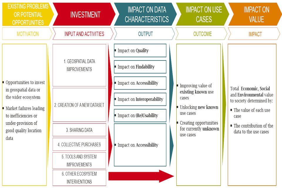
This figure sets out a theory of change for geospatial data investments, covering 5 stages: (1) Existing problems or potential opportunities (2) Investment (3 )Impact on data characteristics (4) Impact on use cases (5) Impact on value
When estimating and assessing the Impact on Value, readers should consider a prioritised set of impacts based on whether they are:
- Expected to generate the largest economic, social and environmental impacts
- Perceived to be most important to stakeholders
- Quantifiable via proportionate analysis
Approaches to assessing value may be (i) fully quantitative when use cases are known and more certain, (ii) indicatively quantitative, reflecting use cases and applications which are relatively uncertain or challenging to estimate, and/or (iii) qualitative, where use cases and applications are the most uncertain and difficult to predict.
For location data investments, it is often the case that benefits are wide ranging, where its timing and scale is uncertain. Qualitative assessments are therefore important to account for these impacts and should be assessed, acknowledged and recorded as part of the wider assessment of value alongside any quantified or indicative benefits.