Helston: reducing the risk of flooding
Updated 4 January 2022

© Crown copyright 2022
This publication is licensed under the terms of the Open Government Licence v3.0 except where otherwise stated. To view this licence, visit nationalarchives.gov.uk/doc/open-government-licence/version/3 or write to the Information Policy Team, The National Archives, Kew, London TW9 4DU, or email: psi@nationalarchives.gov.uk.
Where we have identified any third party copyright information you will need to obtain permission from the copyright holders concerned.
This publication is available at https://www.gov.uk/government/publications/helston-reducing-the-risk-of-flooding/helston-reducing-the-risk-of-flooding
Flood history at Helston
Helston has a long history of flooding, with flood events occurring regularly throughout the 20th Century.
In response to this the Helston (River Cober) flood alleviation scheme was developed in 1989. However, since its construction there have been a number of significant floods due to extreme weather events.
- 1945, 1979, 1988: tunnel blockage at Loe Bar combined with heavy rain
- 1993: overflow of the Town Leat flooded 50 properties
- 1999: river and surface flooding of 3 homes and the Methodist Chapel
- 2003: river flooding of 20 properties
- 2012: river water flowed out of the River Cober back up the leat below St Johns bridge, as well as road gullies affecting 4 properties
Why does Helston flood?
Helston is vulnerable to river flooding in times of heavy or prolonged rainfall.
Loe Pool
Loe Pool is a freshwater pool formed by the blocking of the river mouth by Loe Bar. The River Cober discharges through a tunnel under the bar. Water levels rise in Loe Pool when the amount of water flowing into the pool exceeds the capacity of the tunnel. Since 2000 this risk has been successfully managed by deploying large mobile pumps at Loe Bar to pump the excess water into the sea.
River Cober
High rainfall can cause river levels to rise above the arches of St John’s Road bridge, causing water to overflow the bank and progress down St John’s Road.
Leats
High rainfall can cause water levels to rise and overtop the banks of Mill Leat and Town Leat (the smaller streams running alongside the River Cober) or flow out of gullies onto the road.
Surface water flooding
During intense rainfall, the runoff overwhelms the drainage system and causes surface water flooding in Helston.
Large pumps set up on the beach at Loe Pool to pump water from Loe Pool and through Loe Bar and out to sea
Helston flood alleviation scheme 1989
Work on the Helston flood alleviation scheme began in 1989. Key improvements included:
- the construction of a second arch through St. John’s Road bridge
- installation of low-flow boards from St John’s Road through to the Porthleven Road to reduce the need for maintenance dredging
- channel improvement and de-silting of the River Cober between Zachary’s Bridge and Loe Pool
The scheme was successful in lowering the flood risk and reducing the need for river dredging. However, following these improvement works there were further flood events.
Although Kerrier Town Council made improvements to the Town Leat following the 1993 flood, it was determined that further work was needed to reduce the risk of flooding at Helston, and improve the town’s resilience to climate change.
Loe Bar improvements 2019
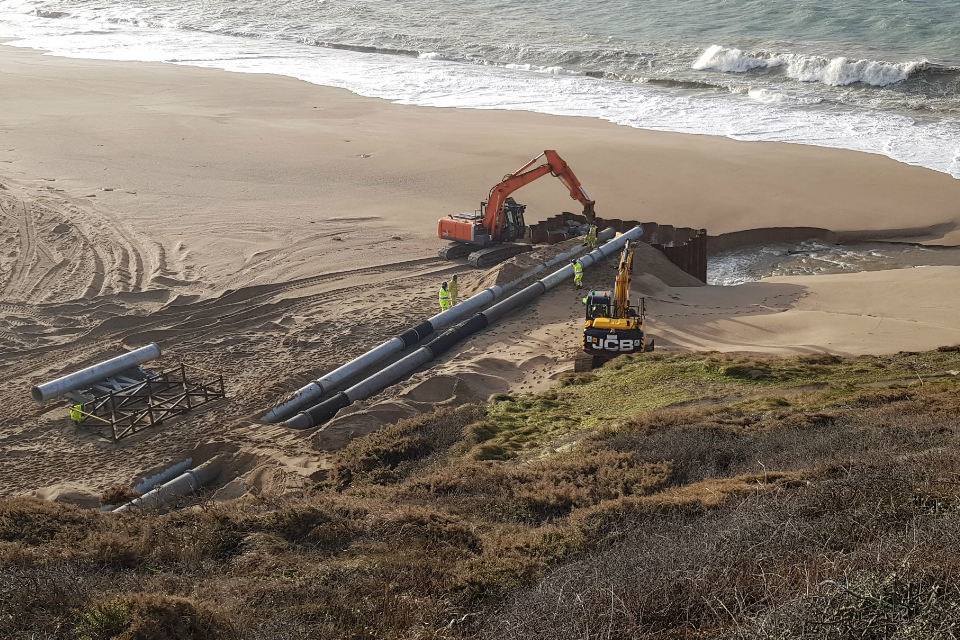
In 2019 the Environment Agency carried out work at Loe Bar to provide additional capacity for water to discharge from Loe Pool. This included the construction of a new 185 metre long, 1.8 metre diameter flood relief pipe below Loe Bar, and repairs to the existing tunnel. The inlet structure was modified to allow the water level to be managed to improve the quality of the habitat around the margins of the pool which is a Site of Special Scientific Interest.
River Cober work 2020
In December 2020 the Environment Agency completed the second phase of the Helston scheme. Combined with the phase one work at Loe Bar the scheme totalled £5.4 million, reducing flood risk from the River Cober.
The work included:
- a reinforced earth embankment along the left bank of the River Cober, from Mill Lane to St John’s Road Bridge
- a road ramp towards the end of Mill Lane to prevent flood waters bypassing the flood embankment
- flood walls along the left bank of the River Cober, between St John’s Road bridge and Penzance Road (County Bridge)
- a flood gate at the Kingdom Hall access bridge which will be closed when a flood warning is issued
The scheme has significantly reduced the risk of flooding along the eastern bank of the River Cober from 20% to 1% in any one year, protecting an additional 121 properties in Helston.
In addition to reducing flood risk, the scheme was designed to be as sustainable as possible. Efforts were taken to keep tree removal to a minimum, replacing every tree that was removed. A further 500 trees have been planted at a nearby site in Helston as part of the scheme. Local wildlife such as bats and invertebrates will also be encouraged to inhabit the area through the use of bat boxes and woody debris piles.
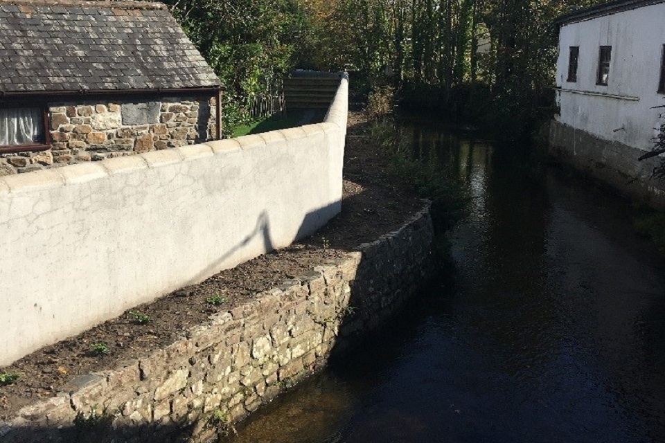
A section of the new flood wall along the left bank of the River Cober, between St John's Road bridge and Penzance Road (County Bridge)
Awards
The scheme has won 2 awards since completion:
- The Institute of Civil Engineering South West Civil Engineering Awards 2021 - Project Under £8 million (Re-Engineered) Award. The judges were impressed with the trusting relationship the project team were able to foster with the local community, enabling them to continue to work in people’s back gardens during the national lockdown.
- Ground Engineering Awards 2021 - Gold Green Apple Award for Environmental Best Practice
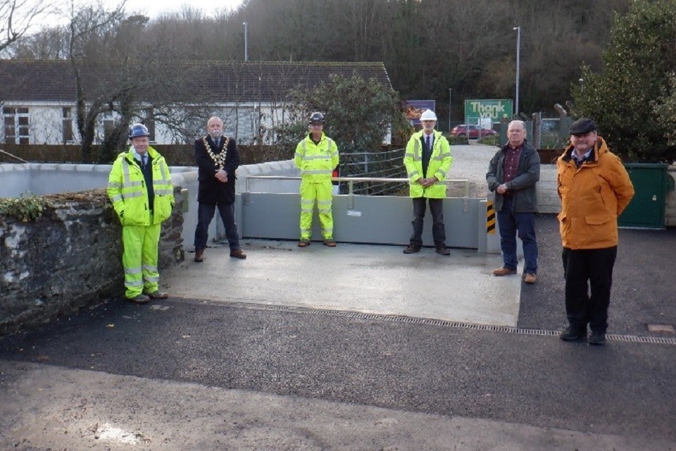
Official opening of the Helston project, with the Mayor of Helston, 16 December 2020
Contact
For further information email DCISEnquiries@environment-agency.gov.uk or phone 03708 506 506.