Fens 2100+: Summary baseline report
Published 2 April 2026
Applies to England

© Crown copyright 2026
This publication is licensed under the terms of the Open Government Licence v3.0 except where otherwise stated. To view this licence, visit nationalarchives.gov.uk/doc/open-government-licence/version/3 or write to the Information Policy Team, The National Archives, Kew, London TW9 4DU, or email: psi@nationalarchives.gov.uk.
Where we have identified any third party copyright information you will need to obtain permission from the copyright holders concerned.
This publication is available at https://www.gov.uk/government/publications/fens-2100/fens-2100-summary-baseline-report
1. Foreword
A solid base for future action
The Fens is a man-made and constantly managed landscape, unlike any other. Without management, there is no landscape. Our evidence is clear: there is no business-as-usual approach that can keep the Fens safe and productive.
This suite of baseline reports represents the first time that all partners have had a unified evidence base of the whole flood risk management system. It supports a shared:
- understanding of the issues and challenges
- story of the value this management brings
Fens 2100+ is pushing forward a transformative new approach to investing in the critical flood and coastal erosion risk management (FCERM) infrastructure that underpins the Fens. By collectively developing a long-term, landscape-scale flood resilience programme, we can all support a climate-resilient, vibrant, and sustainable future for the Fens region.
The Catchment Baseline Reports, and this summary report, provide a clear, shared evidence base that can be drawn upon by all partners to plan, fund and deliver investments to support both our place-keeping and place-making missions. This evidence was built in partnership to secure the future of this unique region.
2. Our partnership
This partnership report is written for and on behalf of the Fens 2100+ partnership. It includes regional leadership and representation from:
- Regional flood and coastal committees (RFCCs)
- National Farmers Union (NFU)
- Anglian Water
- Cambridgeshire County Council
- Norfolk County Council
- Lincolnshire County Council
- Association of Drainage Authorities (ADA)
- Natural England
- Cambridgeshire and Peterborough Combined Authority
- Environment Agency
- Middle Level Commissioners
- Black Sluice Internal Drainage Board (IDB)
- Welland and Deepings IDB
Image 1: Fens 2100+ partner logos. Image credit TBC.
This document draws upon the individual Catchment Baseline Reports and technical appendices. It also uses baselines for:
- flood risk
- economics
- environment and agriculture
- natural capital
You can get more information by emailing Fens2100@environment-agency.gov.uk
This document has been produced by Arup in collaboration with:
- the Environment Agency
- Rivelin Bridge
- the Fens 2100+ partners
It is part of a wider programme of work, drawing from engagement across the area and sector.
3. The report in context
A robust evidence base to inform decision making
For the first time, we have a collective set of robust evidence and important insights about flood risk and asset performance across the Fens. This equips decision-makers to shape the future of the Fens with confidence and clarity.
This report summarises findings from a suite of Catchment Baseline Reports. It brings together data and insights from risk management authorities (RMAs) on their experience of managing flood risk assets.
Information includes:
- the historical and environmental context
- the function of flood risk assets and their economic impact
- current and future flood risks
- investment challenges and opportunities
This offers a collective evidence base to support the Fens 2100+ Partnership in transforming the approach to investing in flood and coastal resilience.
This includes:
- making decisions about the maintenance, management, and investment prioritisation of critical assets, which are ageing and under increasing pressure from climate change
- supporting the preparation and successful delivery of future FCERM business cases, and partnership working to secure future funding and finance
- addressing how the area will function in the future, balancing flood risk, water supply, sustainability and economic growth
4. Introduction
The evidence is clear: without urgent, sustained investment to maintain and upgrade critical flood risk management infrastructure, we risk being the generation that failed to protect the future of the Fens.
4.1 A landscape worth protecting
The Fens supports a concentration of agricultural output which could not be replicated anywhere else in the UK. The Fens contains 48% of England’s Grade 1 (best and most versatile) agricultural land. Its thriving agricultural economy supports 80,000 jobs.
There are 105 designated sites for nature conservation, including internationally important sites such as:
- The Wash
- Gibraltar Point
These which provide habitats for many important species. Natural capital delivers £500 million in annual benefits, including:
- food production
- flood risk management
- clean water
- recreation
With a rich cultural heritage dating back to the Iron Age and Roman times, the area contains over 4,000 designated heritage assets.
Flood risk management assets in the Fens protect critical transport infrastructure and essential power and water supply utilities from damage and disruption. These are worth £8.1 billion and £5.1 billion respectively. Through this they underpin wider economic growth across eastern England.
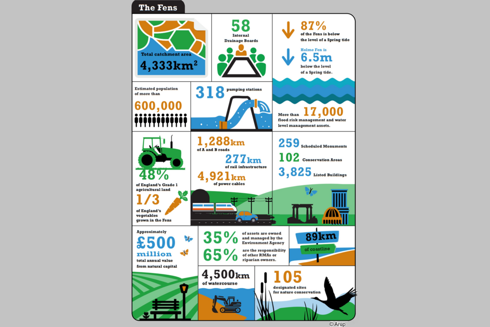
Image 2 - Important facts and figures related to the Fens study area. Credit: Arup.
4.2 What the challenge is
Continuous land drainage and flood defences are all that protect low-lying areas from permanent inundation. The lives and livelihoods of over 600,000 people who live in the Fens would be put at risk without these critical assets. Flood damages would exceed £60 billion over the next 100 years.
Yet around 31% of flood risk assets in the Fens will reach the end of their foreseeable design life within 15 years. This includes critical:
- embankments
- pumps
- control gates
By 2075, the proportion of assets which will reach or be beyond their foreseeable design life will be 89%.
Many of the 17,000 flood risk assets that sustain the region were built in the post-war decades. This was the last period of mass investment in drainage infrastructure. Maintaining and managing such a complex system of assets requires significant resources and collaboration between RMAs.
Repeated flooding events highlight the region’s vulnerability. Climate change will intensify this risk, even if current defences are maintained.
5. The Fens: context and overview
The Fens is a landscape of national importance. It combines:
- exceptionally productive agriculture
- internationally significant sites for biodiversity
- a rich cultural heritage
The Fens 2100+ study area covers 4,333km2 (433,300ha) of the Lincolnshire and Cambridgeshire Fens. The study area is shown in image 3.
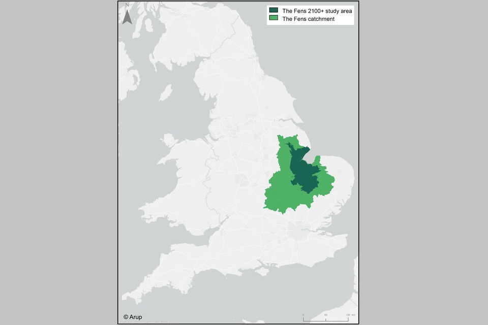
Image 3 - map shows the Fens 2100+ study area around the Wash on the east coast of England. Credit: Arup.
The 4 largest rivers are the:
- Witham
- Welland
- Nene
- Great Ouse
Together, they drain water from 12% of England through the Fens into The Wash.
Image 4 shows the river catchments making up the study area.
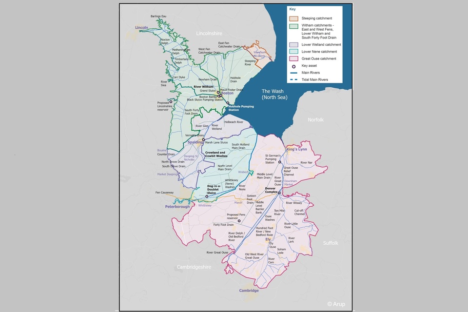
Image 4 - The total Fens 2100+ study area, made up of 5 river catchments. Credit: Arup.
Large areas of the Fens lie below sea level. Inland, it is bordered by the:
- Lincolnshire Wolds
- Southern Lincolnshire Edge
- higher ground of Cambridgeshire and East Anglia
A low ridge of silt and sediment along the coast of The Wash forms a bowl, with the lowest areas further from the coast. The UK’s lowest point, 2.75m below sea level, is in Holme Fen, south of Whittlesey in the Great Ouse catchment.
Due to its flat and low-lying topography, the Fens can only be kept dry by a complex system of flood risk management assets.
Constant management of water and the rich peaty soils left behind by the drainage enable the region to support incredibly productive agriculture. The Fens contains around half of the UK’s Grade 1 agricultural land. It contributes over 7% to the UK’s total agricultural production.
Once a waterlogged landscape periodically inundated by rivers and the sea, the Fens has been dramatically transformed. Over the last thousand years, humans have constructed an extensive network of drainage channels, embankments, and pumping stations. Together, these aim to keep the area flood free and well drained.
Without active management 365 days per year, the region would be flooded from rivers and the sea. Centuries of land subsidence due to the shrinking of drained peat as it dries and oxidises have left many rivers elevated above their floodplains. They are contained by artificial earthen embankments, which were raised as land levels fell. Pumping water upwards into these rivers and maintaining the embankments has since been vital to prevent inundation and keep the area habitable and productive.
Climate change is expected to increase the frequency and severity of fluvial and tidal flooding as well as drought. Ongoing drainage and intensive agriculture continue to accelerate peat subsidence. This:
- further lowers ground levels
- releases stored carbon
- erodes the most fertile soils
Climate change is also expected to accelerate the rate of asset deterioration. This will demand more frequent maintenance, and shorter periods between renewals.
Maintaining current defences is expected to cost between £6 and £9.4 billion. This doesn’t include the upgrades needed to make the asset system resilient to climate change.
5.1 Agriculture
Almost half of the best quality agricultural land in England is located within the Fens. This land produces a fifth of England’s crops and a third of its vegetables.
Image 5 shows the distribution of the agricultural land across the Fens.
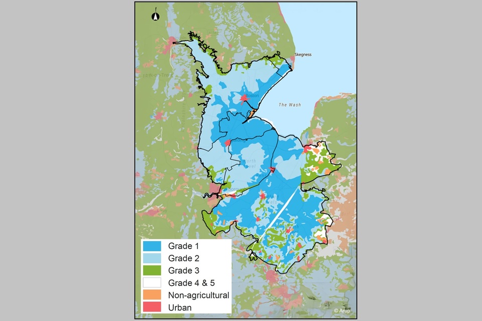
Image 5 - The distribution of the different types of agricultural land classifications across the Fens study area. Credit: Arup
The area supports a high value food processing and logistics hub, which is supported by academic institutions to create innovation and add value. The agricultural land supports approximately 80,000 jobs across the food supply chain.
Agricultural success here depends on managing flood risk and water levels. These activities must:
- make sure there is enough water for irrigation in dry summers
- provide protection from flooding and waterlogging in wetter conditions and during extreme weather events
The impacts of drought and flood events on agriculture can be severe. Even after floodwaters have receded, salinisation (caused by tidal flooding or groundwater leaching) can have long-term impacts on soil health and productivity.
5.2 Human environment
The Fens has a rich cultural heritage dating back to the Iron Age and Roman periods. It possesses over 4,000 designated heritage assets. These include:
- 3,825 listed buildings
- 259 scheduled monuments
- 102 conservation areas
Peat soils may preserve many more as yet undiscovered archaeological remains.
Culturally there has been a strong connectedness with water across the Fens. This runs from the ‘Adventurers’ who undertook the major drainage works of the 1600s, to the wildfowlers who depended on natural wetland resources for subsistence and trade. This connection has diminished over recent history.
Although only 3% of the area is urban, the Fens’ population is growing faster than the national average. Boston Borough’s population is projected to grow by 9.1% between 2025 and 2041, compared to 6% for England.
However, there is stark inequality. Some areas face:
- deprivation
- low life expectancy
- poor health
- limited access to green space and skills development
Parts of the region rank in the bottom 1% nationally for education, skills, and training.
The strong growth ambitions of the region are dependent on critical flood, coastal and water management infrastructure.
5.3 Natural environment
Biodiversity
Less than 1% of original fen habitats survive, yet the region still supports:
- rare plants
- insects
- over 170 bird species
There are 105 sites across the Fens which have been designated for their national or international importance for biodiversity.
The Whittlesey (Nene) Washes flood storage area is designated as a:
- Special Protected Area (SPA)
- Site of Special Scientific Interest (SSSI)
- Special Area of Conservation (SAC)
- Ramsar Site
Intermittent flooding supports diverse wildlife and preserves peaty soils through the high water table.
Water environment
The condition of waterbodies is described by their Water Environment Regulations (WER) / Water Framework Directive (WFD) status. Most water bodies in the Fens are heavily modified or artificial. They are affected by pollution from rural areas and wastewater, and by physical modifications. These modifications are associated with:
- flood defence structures
- land drainage operations
- uniform channel geometry
5.4 Landscape
The study area is mainly within The Fens National Character Area, notable for its flat, open landscape and wide views. The network of rivers, drains and ditches forms a distinctive geometric field pattern. Level horizons contribute to a strong sense of isolation and tranquillity.
Soils
Peaty soils cover 18% of the Fens. They are deepest in washlands such as the Whittlesey (Nene) Washes, and across much of the South Level in the Great Ouse catchment. Much of the remnant lowland peat present across the Fens is likely to be degraded due to long-term agricultural use and drainage. There is significant potential for enhanced carbon sequestration.
5.5 Natural capital
Natural capital refers to elements of the natural environment that provide valuable goods and services to people. Benefits provided by natural capital assets such as freshwater, soils, air, plants and animals are known as ‘ecosystem services’.
These ecosystem services support human wellbeing and the economy by supplying:
- raw materials
- food
- clean water
- carbon storage
- temperature regulation
- pollination
- opportunities for recreation
Their value can be estimated using data on the quantity, quality, location, and use of natural assets.
Almost £500 million of natural capital has been identified across the Fens. This value may be underestimated due to data gaps or the complexity of assigning monetary value.
Most of the natural capital value in the Fens derives from agriculture (£376m) and water supply (£382m).
Other natural capital value includes:
- Timber: +£1.2million
- Renewable energy: +£15.3 million
- Climate regulation (carbon): -£359 million
- Air quality: +£6 million
- Recreation: +£53 million
- Physical health: +£22 million
- Water quality: +£2.6 million
The value of education, volunteering and hazard regulation is shown to be zero. The value is greater that this but there is insufficient data available to provide a monetary value.
Image 6 shows the value of natural capital across the Fens.
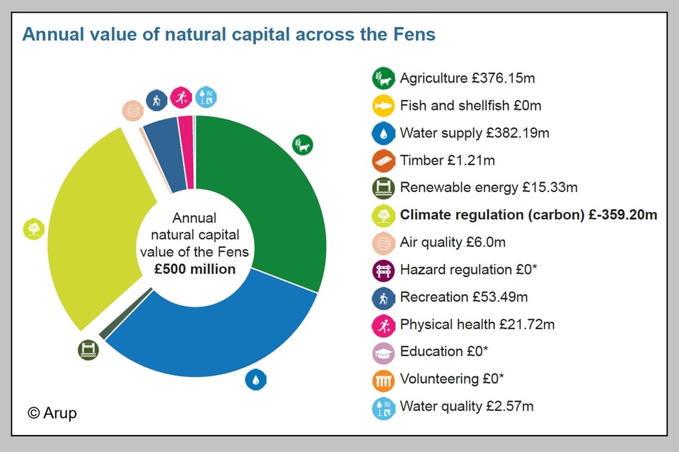
Image 6 - Annual value of natural capital across the Fens. Credit: Arup
The way that water is managed across the landscape is not always joined up. There are significant opportunities to unlock wider natural capital value in both of these areas through future flood risk management approaches.
Across the Fens, natural capital value is supressed due to high carbon emissions. Healthy peat soils store carbon, but degraded peat soils release it, worsening climate change and reducing peatland value. All Fens 2100+ catchments (except the Steeping River catchment) emit more carbon than they absorb, costing £359 million annually.
Even accounting for the cost of carbon emissions, the natural capital across the Fens provides services with a total annual value of approximately £500 million.
6. History of the Fens
Change has been a constant feature of the Fens landscape. From the earliest human settlements, and particularly since the 1600s, people have actively managed the flow of water across the region.
6.1 Natural wetlands and early settlement
Remains of ancient oak trees, or ‘bog oaks’, found in fenland peat are evidence of a once densely forested landscape. Around 5,000 years ago, rising sea levels created wetlands, burying and preserving the trees. Tidal rivers deposited silt, often blocking flow and causing frequent floods that formed inland lakes, or ‘meres’.
Human settlement in the Fens dates to the Neolithic period. By the end of Roman rule (AD 43–410), early flood defences and navigation improvements had begun. This included construction of the:
- Carr Dyke
- raised Fen Causeway between Peterborough and Denver
Salt production was among the earliest industries. Waste silt from this process formed ‘salterns’, or elevated coastal areas where villages developed.
6.2 Local drainage and monastic influence
During the Saxon period (AD 410–1066), settlements and monastic foundations were created on some of the raised Fen ‘islands’. Examples included:
- Crowland
- Ely
- Thorney
- Ramsey
Communities farmed, fished, hunted, harvested reeds, and produced salt. In the 1100s, some of the first dykes were dug by monks for transporting goods.
The ports of King’s Lynn, Boston, and Wainfleet thrived through the medieval period (1066–1485), from the trade of wool and fenland resources. Drainage efforts were mainly limited to small flood embankments, raised by local landowners.
6.3 The ‘Great Draining’
In the 1600s, draining the peat-rich Fens was seen as a way to create profitable farmland. In 1630, the Fourth Earl of Bedford and a group of investors, known as the ‘Adventurers’, appointed Dutch engineer Cornelius Vermuyden. He led major drainage works in the Great Ouse and Lower Nene catchments. His approach focused on straightening rivers to speed up the flow of water to the sea. Navigation and river trading were also important drivers for investment at this time.
Further north, the Earl of Lindsey attempted to drain the South Forty Foot Drain catchment in 1635–1638. These changes angered locals who relied on the Fens for fishing and hunting. In protest, they sabotaged the new works and became known as the ‘Fen Tigers’.
6.4 The emergence of pumping
Although drainage schemes produced results initially, it became apparent that the peaty soils were shrinking as the land began to dry. This impeded the natural flow of water along the new channels. Windmills transformed drainage by allowing water to be moved upwards from the land into the embanked watercourses above.
Large undrained areas remained until steam pumps were introduced in the mid-1800s. These pumped 8 times more water than windmills and could run continuously, revolutionising drainage and boosting agricultural production.
6.5 Post-war investment
The outbreak of World Wars and the associated periods of food rationing in the 1900s raised the importance of national food security. In the Fens this prompted a renewed wave of investment in drainage. This was supported by the 1930 Land Drainage Act which created many of the organisations that we see today.
In the interwar period, the first investments in more intensive modern drainage began. Tydd Pumping Station was commissioned to intensify drainage of the North Level, and the first electrical pumps were installed at Pode Hole in 1937.
Major flood events in 1947 and 1953 renewed the focus on flood protection. New relief channels were dug, and main rivers were straightened and embanked. In the 1950s and 1960s, a wave of new diesel and electric pumps were built across the Fens. These post-war assets are now coming to the end of their foreseeable design life.
6.6 Modern investment
Since the 1980s the level of investment in the Fens has dropped as flood defence spending has focused on protection of properties rather than agricultural land. The globalisation of food markets has also made food security less of a priority.
Since the 2010s, budgets for maintenance of flood risk management assets have also been reduced, with funding bids often under-resourced.
Climate change impacts are now evident. Tidal breaches in 2013, a prolonged wet winter in 2023 to 2024, and a dry summer in 2025 have strained drainage systems, exposing several weaknesses.
7. History timeline
7.1 Natural wetlands and early settlement
Pre-10,000 BC
The area was forested.
43-410 AD
Romans constructed the first artificial channels and the raised Fen Causeway.
600-1000 AD
Monastic foundations were created on some of the raised fen ‘islands’.
7.2 Local drainage and monastic influence
1287
A disastrous tidal surge affected Boston and South Holland. Spalding Monastery was destroyed.
1530s
New laws were passed supporting sewerage and draining, which led to the cutting of new drains.
7.3 ‘The Great Draining’
1600
Windmills started to be used to drain the Fens.
1630s
The River Welland was widened and deepened to improve navigation and drainage.
1630
Cornelius Vermuyden designed a scheme to drain the Lower Nene and Great Ouse catchments.
1632
Approximately 100km2 of land in South Holland was reclaimed from the sea for agriculture.
1664
Crowland and Cowbit Washes were constructed.
1700s
Drainage of Deeping Fen began, and the River Witham was straightened to improve navigation.
1799
Drainage of the East and West Fens begins.
Water which had once flowed into the Steeping River from the East Fen was now diverted towards the River Witham.
7.4 Emergence of pumping
1820s
Steam powered engines began to replace windmills.
1851
Whittlesey Mere finally vanished due to drainage. It had once been the largest lowland lake in England.
1899
Wicken Fen became the National Trust’s first nature reserve.
1930
The Land Drainage Act created IDBs and Catchment Boards.
1934
The first St. German’s Pumping Station was constructed, after it was realised that gravity alone was insufficient for draining the Middle Level.
7.5 Post-war investment
1937
Dog-in-a-Doublet Sluice constructed.
1940s
Following severe flooding on the River Welland in 1947, construction of the new Coronation Channel began.
1953
The North Sea tidal surge was the UK’s worst natural disaster of the 20th Century.
1956-1957
Large pumping stations were commissioned at Pode Hole and Hobhole to boost drainage of Deeping Fen and the East and West Fens.
1960s - 1970s
Embankments were raised along highland carrier drains, and relief channels were constructed in the Steeping River catchment to increase the capacity of the river network.
1973-1993
Further investment in diesel and electric pumps. Ten new diesel and electric pumping stations were constructed in the North Level District.
7.6 Modernisation
1990s-2000s
A new telemetry system was installed in the East and West Fens, enabling remote monitoring of water levels and automated adjustment of assets.
1998
Following heavy rainfall, St. German’s Pumping Station ran continuously for 12 days. This prompted construction of a new pumping station in 2010 – the largest pumping station in England.
2013
A tidal surge breached embanked defences at Wrangle and Boston, and damaged Black Sluice Pumping Station, which led to its closure.
2018
5.8km of sea defences at Wrangle were raised to a height of 7.2m.
2020
Construction of Boston Barrier completed to provide tidal surge protection for the town, with allowance for sea level rise.
7.7 Now and next
2020
FCERM national strategy measure 1.5.4 led to the Fens 2100+ Partnership.
2023-2024
The wettest winter on record for the UK pushed flood risk assets in the Fens to their limits and beyond.
January 2025
Water levels in the South Forty Foot Drain were the highest ever recorded.
2040
31% of flood risk assets in the Fens will come to the end of their foreseeable design life. By 2075, this rises to 89%.
2080s
Peak flows in rivers across the Fens could be between 4% and 21% higher than those recorded currently.
2125
1.2-1.6m of sea level rise projected under the UK Government’s ‘Upper End’ allowance.
8. The role of critical infrastructure
Without critical flood risk management assets, the Fens would quickly flood and become uninhabitable.
8.1 A changing landscape
Before human intervention, the Fens was a rich wetland. Features included:
- meres
- bogs
- woodland
- salt marshes
Natural islands supported drier habitats.
Over centuries, major effort and investment has transformed the area into a habitable and productive landscape. Without ongoing management and flood defences, the Fens would quickly flood from rivers and the sea and become uninhabitable.
8.2 Importance of the flood risk management asset system
Effective drainage in the Fens depends on pumping stations and well-maintained river and tidal embankments. Sluices and control structures help manage water levels to prevent breaches.
These flood defences are actively managed year-round. Without them, or if they were neglected, the Fens would quickly flood. If all pumps stopped, the area would become uninhabitable within less than a decade.
8.3 Legacy investment
The flood risk management system we have today was inherited from previous generations and made possible by substantial investment. Many of the largest drainage features such as channels and embankments were dug by hand, at huge financial and human cost. Projects of this scale are unlikely to be feasible under current conditions; at the time, they required several Acts of Parliament to proceed. In today’s terms, replicating a similar system from nothing would cost in the region of £25 to £30 billion.
9. Extent of permanent inundation
Map XX shows the tidal flood risk in the Fens without flood defences. Much of the land lies below the mean high spring tide (MHWS) level of 3.9m AOD. It is highly vulnerable to tidal inundation. The Fens has a bowl-shaped topography with lower ground inland of the elevated coastal areas. This traps water, preventing natural drainage. The UK’s lowest point lies 2.75m below AOD at Holme Fen. During a high spring tide (MHWS), the sea level is more than 6.5m above the land surface at Holme Fen — equivalent in height to a two-storey building. Tidal embankments are the only defence against this flooding being realised with each spring tide.
9.1 Why the Fens landscape is a bowl
One of the reasons that the Fens today is vulnerable to flooding is its distinctive bowl-shaped topography. As water has been removed from the peaty soils further inland, the ground has shrunk and subsided significantly. As a result, it now sits below the natural ridges of silt nearer to the coast, where the earliest settlements were established. In the mid-1800s, the peat at Holme Fen was over 6.5m deep, but in the past 175 years the ground level there has dropped by around 4m.
This creates a striking paradox: the more the land is drained, the more the peat soil shrinks, creating a cycle which has made the Fens increasingly dependent on pumped drainage to move water upwards against gravity, towards The Wash.
Image 7 shows the extent of inundation that would occur during the Mean High Water Spring (MHWS) tide if operation of the existing assets were to cease.
The MHWS for this location has been calculated to be 3.9m Above Ordnance Datum (AOD). Image 7 also shows:
* that most of the study area would be underwater. * the location of Holme Fen, the lowest point in the United Kingdom at 2.75m AOD, which is located 47km from the sea - this is shown in image 8
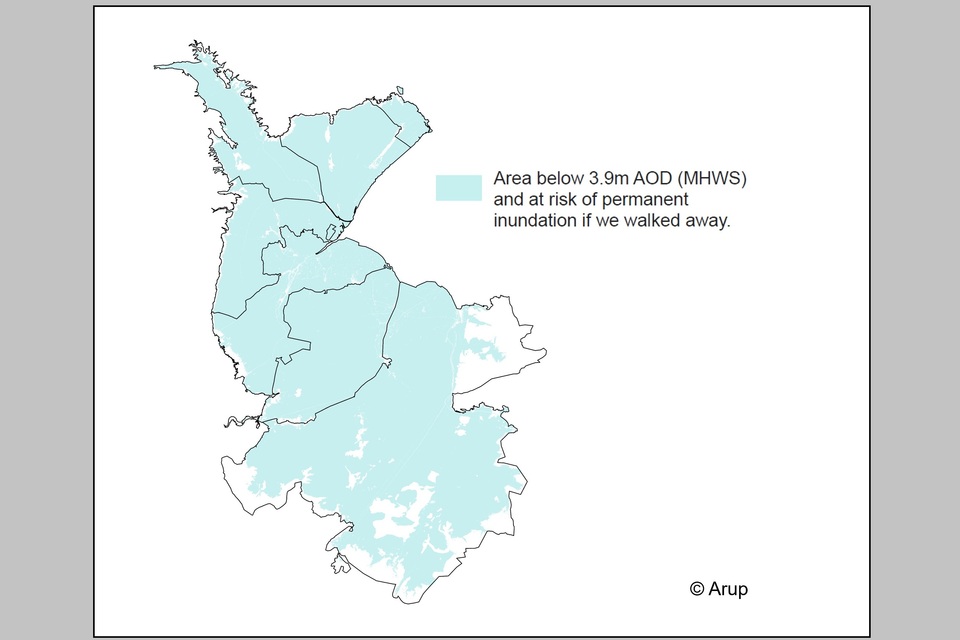
Image 7 - the extent of inundation that would occur during the Mean High Water Spring (MHWS) tide if operation of the existing assets were to cease. Credit: Arup.
87% of the Fens is below 3.9m AOD (MHWS) and at risk of permanent inundation if we walked away.
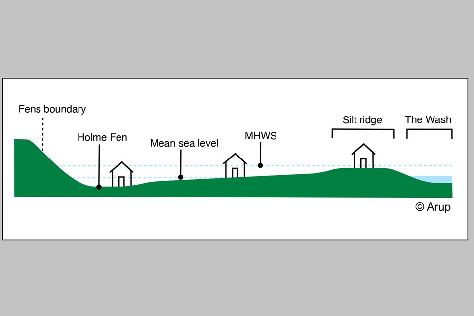
Image 8 - an indicative cross section of the Fens, from Holme Fen to the Wash. Credit: Arup
10. Flood risk asset system
Given the scale and complexity of the asset system, spanning more than 17,000 interconnected assets, systems thinking is central to the future of the Fens. No single organisation can solve the challenge alone.
Image 9 illustrates most important flood risk management assets which protect the Fens from flooding. Thousands more assets exist to support flood risk reduction, navigation and the maintenance of water resources.
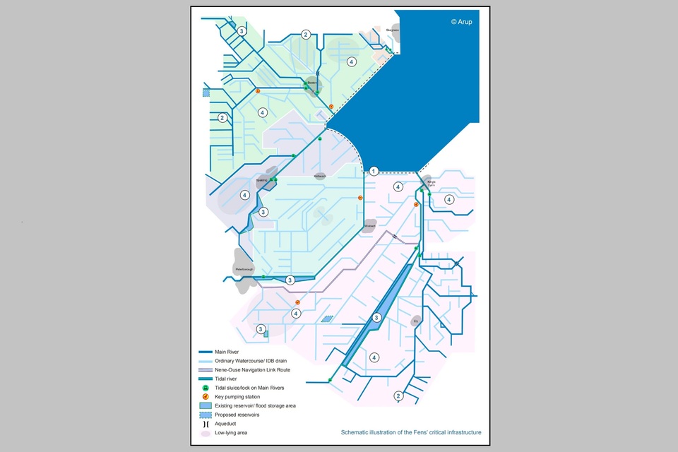
Image 9 - the extensive network of drains and watercourses across the Fens study area and the main assets. Credit: Arup
Responsibilities for different assets are split across multiple organisations with varying priorities:
- around 35% of assets are owned and managed by the Environment Agency
- 65% the responsibility of other RMAs or riparian owners
10.1 Coastal defences
Walls and embankments are in place along the coast and tidal rivers to prevent coastal flooding. These defences are stressed by the daily cycles of the tides and are increasingly under pressure from sea level rise. They can be very high to provide protection for regular spring (higher) tides, as well as tidal surges potentially caused by storms. At Wrangle, the embankments are up to 7m tall.
10.2 Main river defences
Main rivers often sit above surrounding land due to subsidence. Embankments contain these elevated ‘highland carrier’ channels. Catchwater drains intercept runoff from higher ground before it reaches low-lying areas.
Sluices manage water levels in main rivers by releasing water before floods and retaining it during dry spells. They also support navigation and aquatic habitats.
10.3 Flood storage areas
Flood storage areas, or washlands, are a prominent feature of the Fens and are present in 4 of the 7 catchments. They are usually dry and are managed for wildlife and used for grazing, or other types of agriculture. But when river levels are high, they can be used to store excess water, which is kept within the storage area by earthen embankments.
10.4 Pumped and gravity drainage systems
Due to peat shrinkage and the flatness of the landscape, many watercourses in the Fens lack the natural gradient typical of rivers elsewhere. This means water must sometimes move ‘uphill’ to enter the main river system or the sea. The movement of water off the land is therefore largely reliant on pumping stations.
Some sub-catchments with suitable topography can be sufficiently drained through gravity sluices alone. However, as sea levels rise, and land continues to subside, gravity drainage is becoming increasingly unreliable.
10.5 Dual-purpose assets
Many assets serve a dual purpose, alongside managing flood risk. For example, several sluice structures can manage water levels for:
- flood risk reduction
- navigation
- environmental protection
- water supply for homes and agriculture
Competing objectives make the management of these assets particularly complicated.
10.6 Asset condition and performance
Consulting asset owners and operators was central to the baseline reports, capturing real-world management experience. Combined with the Environment Agency’s Asset Information and Maintenance dataset (AIMS) data, this revealed shared challenges for RMAs. It underscored the need for ongoing collaboration and investment in asset condition.
Despite its vital role in protecting the Fens, the flood risk management system faces growing challenges. Ageing infrastructure, operational complexity, and competing demands are creating vulnerabilities that hinder efforts to safeguard people, property, and the environment.
10.7 The asset system is complex
Flood risk assets in the Fens form an interconnected network. One asset alone seldom provides complete defence of an area against flooding.
Decisions taken at one site – such as increasing pumping rate, or lowering water levels – can affect other assets downstream. This shifts the demand for water management between assets and sometimes organisations.
Seasonal extremes add further complexity;
- winter rainfall demands rapid drainage
- summer requires water retention to support navigation and irrigation
The Fens is one of the driest areas in the country overall, but drains the rainfall from a much larger area, covering 12% of England. These extremes of wet and dry are projected to worsen with climate change.
10.8 People and skills are vital
Specialist skills are essential to manage these assets. During floods, important sites like Hobhole Pumping Station and Denver Sluice require 24/7 staffing. This limits the Environment Agency and IDBs’ ability to respond to issues elsewhere. Recruiting and retaining skilled staff is difficult, and these RMAs stress the need to preserve institutional knowledge before it disappears.
10.9 Assets are ageing
Many critical assets in the Fens are ageing, with some exceeding their foreseeable design life. This:
- raises the risk of failure
- increases maintenance costs
- reduces efficiency
By 2040, 31% of flood risk management assets will reach the end of their foreseeable design life, and by 2075, this will increase to 89%.
In areas where many assets were built at the same time, the risks around ageing assets are compounded. One failure could cascade onto a neighbouring asset of similar vulnerability. Extending asset life may ease short-term investment pressures but will not remove the eventual need for large investments in asset replacement.
- 35:65 split of asset ownership Environment Agency and other Risk Management Authorities
- 31% of assets across the Fens will reach or be beyond their foreseeable design life by 2040
Case study: Ageing components at Dog-in-a-Doublet Sluice
Built in 1937, Dog-in-a-Doublet Sluice is nearly 90 years old and forms the upstream limit of tidal defences on the River Nene.
It controls water levels for:
- navigation
- water supply
- agriculture
It suffers frequent mechanical failures from constant telemetry adjustments, and sourcing parts is costly and difficult. Planned renewal could extend its life by 20 years, but full replacement will eventually be required.
10.10 Pumped systems are at capacity
Many Fens pumping stations are outdated and operating at capacity, having been designed for lower peak flows. Each was built to reflect the technology of their time, without standardisation. The bespoke designs and mismatched components of different assets makes repairs difficult. They are reliant on a small pool of very skilled individuals.
Long lead times for parts often leave pumps offline or underperforming. This reduces system capacity and increases flood risk in local sub-catchments during outages.
10.11 Gravity discharge is becoming more difficult
Many Fens sub-catchments rely on gravity-controlled drainage, which depends on low tide levels to let water flow out to sea.
However, gravity discharge is now much harder than when these systems were built. Sinking of the land over time due to peat shrinkage has flattened the natural slope of watercourses, making it harder for water to move. At the same time, rising sea levels reduce the time available for discharge at low tide. This creates longer periods of ‘tide-lock’ when no discharge is possible. In addition, silt can build up near outfall sluices. This further blocks the flow and contributes to increased flood risk due to water backing up in the catchment.
Case study: Future loss of gravity discharge at Sutton Bridge Sluice
The South Holland Main Drain in the Lower Nene catchment is the main route for water discharge from an area of 185km2 (18,513ha). This land contains over 10,000 residential properties.
Discharge from the South Holland Main Drain into the River Nene currently relies on gravity discharge through Sutton Bridge Sluice. However, as discharge is only possible at low tide, there are periods of ‘tide-lock’ when no discharge is possible. Future sea level rise driven by climate change could restrict gravity discharge even further, and it will become necessary to add a new pumping station at this site.
10.12 Embankments are vulnerable
Many embankments in the Fens were built centuries ago before modern engineering standards, and are formed of variable materials, unsuitable by modern standards. This makes them prone to:
- deformation
- seepage
- failure
Risks are intensified by:
- burrowing animals
- peat shrinkage
- groundwater variations
- unstable clay
All of these threaten the long-term stability of these vital flood defences.
Embankments are vulnerable to climate change, particularly due to the impact of wetting and drying cycles and changes to vegetation. This is expected to accelerate asset deterioration and increase costs through the need for more frequent inspection and maintenance.
Case study: Lower Witham Flood Resilience Project (2025)
Many of the 300km of embankments in the Lower Witham catchment are over 200 years old and prone to failure. Barlings Eau has breached 6 times since 1878, most recently in 2019 and January 2024. Storms in winter 2023-24 caused slips at Fiskerton and a breach on the River Bain.
The Lower Witham Flood Resilience Project aims to improve the resilience of embankments for example through bank re-profiling and the filling of low-spots.
10.13 Better data about asset condition is needed
The AIMS database is an important record of most Environment Agency assets. It includes some other RMA assets, but not all, leaving important gaps in understanding. Even for the assets that are included, data users have raised concerns with how current this data is, potentially under-representing the number of assets currently under stress. 18% of assets across the Fens have no data about their condition
10.14 Strategic co-ordination and governance is essential
Managing assets in the Fens depends on strong collaboration between organisations such as the Environment Agency and IDBs. While coordination and sharing of personnel and resources during flood events is effective, fragmented responsibilities and misaligned priorities threaten long-term, joined-up solutions.
10.15 Assets are carbon intensive
The operation of pumping stations (diesel and electric) is one of the most carbon intensive activities. In the Great Ouse catchment, over 80% of emissions were associated with grid electricity usage at pumping stations. This figure is based on the most recent (2021) annual estimate of emissions from maintenance and electricity usage.
High energy demand makes asset operation vulnerable to fluctuations in energy markets. While many modern stations use electric pumps, many older stations still run on diesel. In many sites a combination of the 2 add resilience in case electricity is cut off during flood events. Rising energy costs and increasing focus on carbon highlight the need for a carbon reduction strategy.
10.16 Climate change will exacerbate asset vulnerability
The deterioration of assets can be driven by multiple climate hazards, including:
- more intense and frequent extreme weather events
- high temperatures
- drought
- heatwaves
These hazards may also compound to exacerbate asset vulnerability. Assets are designed to provide a certain Standard of Service (SoS), but increased exposure to climate hazards will accelerate the deterioration of ageing infrastructure. This will change the frequency, cost, and nature of maintenance activities.
10.17 There are gaps in investment
Investment gaps are leaving the Fens’ flood risk management system increasingly vulnerable. High-cost, high-risk assets such as pumping stations and embankments often remain underfunded. Maintenance is driven by budget constraints rather than actual need.
Maintenance investment is prioritised for assets that pose the highest potential consequences if they fail. Assets that fall below the required condition but have minimal direct impact, particularly in terms of immediate risk to life and property, are given lower priority.
The current ‘fix-on-fail’ approach limits strategic renewal and rationalisation, preventing improvements that would strengthen long-term resilience. As important assets near the end of their foreseeable design life and climate change intensifies pressures, maintenance costs will rise. This will put increasing pressure on limited resources.
Without a shift toward proactive investment in asset renewal and replacement, the system’s ability to protect the region will continue to erode.
10.18 Multifunctional assets present an operational challenge
Alongside all the vulnerabilities and complexities of the flood risk management system, there are other drivers which must be considered.
Flood risk management assets in the Fens are not only vital for protecting people and property from flooding. They also serve multiple, sometimes competing, functions. Many structures, such as sluices and embankments, must balance flood protection with navigation, environmental quality, and water supply.
This creates complex operational decisions: for example, lowering water levels before a storm can reduce flood risk. However, this may render channels unnavigable for boats or disrupt habitats that depend on certain water levels. As climate change intensifies seasonal extremes, asset managers face growing pressure to adapt quickly. Removing excess water in wet winters, yet conserving it during increasingly dry summers.
11. Current and future flood risk
The risk of fluvial and tidal flooding is currently managed well. However, it is set to increase significantly as sea levels and river flows increase.
The Fens is currently well protected from severe flooding by its flood risk management system. A network of assets work together to keep flood risk in the region remarkably low. This network includes:
- coastal and main river defences
- flood storage areas
- pumped and gravity drainage systems
In the decades immediately after the significant investments of the 1950s and 60s, flood events were generally infrequent and impacted smaller areas. They had limited impact on people and property.
However, the climate is changing. In recent years, the system has faced unprecedented stress from increasingly extreme weather. Long wet winters, dry summers and severe storm events have tested the system to its limits, and at times to breaking point.
The continued effectiveness of the flood defence system relies on seamless interaction between assets. This can only be sustained with urgent maintenance investment.
When assets are overwhelmed by exceptional events or breaches, vulnerabilities are exposed. The consequences can be severe, including:
- injury and loss of life
- damage to property, infrastructure, natural habitats and cultural heritage sites
Different mechanisms are amplifying flood risks, including:
- rising sea levels
- more intense rainfall
- land subsidence
These challenges manifest as:
- loss of gravity drainage
- increased river flows
- increasing risk of salination
As climate related pressures increase, the risk of cascading failures also increases, exacerbating and compounding flood risk.
Each catchment is vulnerable in different ways. However, overall it is clear that across the Fens, existing approaches to asset investment, maintenance and renewal are not going to work in the future.
11.1 Fluvial flood risk
At present, the Fens benefits from a remarkably low risk of fluvial flooding. This is the direct result of the extensive system of:
- embankments
- sluices
- critical washlands
- flood storage areas including the Ouse Washes and Whittlesey (Nene) Washes
These storage areas act as buffers, absorbing excess water during periods of high river flow and preventing rivers from overtopping their banks.
Looking ahead, more extreme rainfall under climate change is expected to increase peak river flows in all catchments across the Fens. According to projections from the UK Centre for Ecology and Hydrology and Defra, by the 2080s, central estimates suggest that peak flows could increase by:
- 21% on the Witham
- 17% on the Welland
- 4% on the Nene
- 6-19% on the Great Ouse
As river flows increase, the existing washlands and flood storage areas may no longer be sufficient to manage the higher volumes of water. This means that it may be necessary to create additional water storage areas or expand the capacity of existing ones.
Pumping capacity will also need to be upgraded. This could include:
- adding new or more powerful pumps at existing stations
- introducing additional pumping capability in catchments where water currently drains by gravity
Both will have significant operational cost and carbon implications.
11.2 Areas which are particularly at risk of fluvial flooding
The South Forty Foot Drain catchment has the greatest area currently at risk of fluvial flooding. Under a present day 1% AEP event, 41.7km2 (41,700ha) is at risk. Of this, 40.9km2 (40,900ha) is Grade 1 and 2 agricultural land. Peak flows in the South Forty Foot Drain will increase 20% by the 2080s, with the area at risk increasing 9%.
Flows in the main rivers of the East and West Fens catchment are assumed to increase much more, by 65% over the same period. The East and West Fens catchment is therefore predicted to see the greatest increase in the area at risk of fluvial flooding under climate change. A further 15km2 (1,500ha) will be at risk, of which 13.7km2 (1,370ha) is Grade 1 and 2 agricultural land.
11.3 Risk of embankment breach
What existing fluvial models do not account for is the risk of embankment breach. This is a significant vulnerability across the Fens due to the age and structural instability of many earthen embankments. Fluvial flooding from embankment breach can occur suddenly and is difficult to predict.
Such breaches can release vast volumes of water in a short time, presenting a risk to life and property. Full repairs are likely to be time consuming and costly.
Case study: Failure of the Wainfleet relief Channel embankment
In June 2019, Wainfleet All Saints saw its wettest day on record. Rising water in the Steeping River breached the embankment of the Wainfleet Relief Channel, flooding 8.1km2 of farmland just before harvest. 88 properties and the Boston–Skegness railway line were affected.
It took over 48 hours, and 340 tonnes of material dropped by RAF helicopters to seal the breach. This cost around £1 million.
11.4 Tidal flood risk
Tidal flooding is caused by:
- high tides
- storm surges
- wave action
Current tidal flood risk in the Fens is limited to the most extreme events and to land near the coast. Under a present day 0.5% AEP event, a total of 39.9km2 (3,990ha) is at risk of flooding. This includes 13.2km2 (1,320ha) of Grade 1 agricultural land. Protection against more severe tidal flooding is provided by the 271km of embankments along the coast and tidal rivers. Sluice structures also prevent tides moving further upstream.
However, tidal flood risk is expected to increase significantly over the next 100 years due to sea level rise. The 2010 Northern Area Tidal Model assumes that sea level will rise by 1.1m up to 2115.
The risk increases significantly when this climate change allowance is added to the 0.5% AEP event with existing flood defences in place. The area at risk of tidal flooding across the Fens increases to 382km2 (38,200ha) – representing more than an 8-fold increase. The area of Grade 1 land at risk in this scenario is 209km2 (20,900ha), representing more than a 14-fold increase against the present-day scenario. This demonstrates that tidal flooding will disproportionately affect area of the best and most versatile agricultural land.
Under the Environment Agency’s more recent ‘Higher Central’ and ‘Upper End’ allowances for climate change, sea level could rise by between 1.2m and 1.6m by 2125. This suggests that flood risk will be significantly higher in the future than the model predicts.
Higher sea levels will increase the risk of tide-locking at important outfalls such as:
- Dog-in-a-Doublet Sluice
- Grand Sluice
Tide-locking means that water cannot be discharged from the rivers. This places increasing pressure on embankments upstream which must contain greater volumes of water for longer periods.
Managing the increasing risk of tidal flooding in the Fens in a way that is sustainable and adaptable to future sea level rise will require a coordinated approach. It will also need to align with the shoreline management plan (SMP).
11.5 Which areas are particularly at risk of tidal flooding
Changes to tidal flood risk are not the same across catchments. Under a current 0.5% AEP event, the Great Ouse catchment has the greatest area at risk of tidal flooding, at 14.6km2 (1,456ha). This includes 0.6km2 (60ha) of Grade 1 agricultural land. Under climate change, this area roughly doubles, to a total of 31.3km2 (3,130ha) at risk.
This increase is significant, but it is dwarfed by the increase in tidal flood risk predicted for the East and West Fens catchment. Modelling shows that this catchment has the greatest projected increase in tidal flood risk during a 0.5% AEP event with existing defences in place. Under the present-day scenario, 12km2 (1,200ha) is at risk in the East and West Fens catchment. However, when 1.1m of sea level rise under climate change is applied, the area increases 20-fold to 230km2 (23,000ha). This is greater than the area at risk in the all of the other Fens 2100+ catchments combined, under the same scenario.
- The total area at risk of tidal flooding across the Fens when climate change is applied to the 0.5% AEP event, even with current defences in place, is 382km2
- Compared to the present-day, this represents an 8.5 fold increase
- 60% of the total area at risk of tidal flooding with climate change applied is located within the East and West Fens catchment
11.6 Salinisation risk
Tidal inundation of agricultural land, exacerbated by seepage of saltwater from rising groundwater, can increase the concentrations of salt within the soil. Salt is an essential mineral for crop growth, but at high concentrations can degrade soil quality. This can:
- slow growth
- reduce yields
- cause crop failure
This can have long lasting impacts on productivity of the land.
Case study: 2013 tidal surge
On 5 December 2013, a 6m tidal surge along the east coast of England devastated coastal communities. Over 800 properties were flooded in Boston across 55 streets after the tide overtopped defences along The Haven. The earthen coastal defences at Wrangle, known as the Wrangle Sea Banks were also breached by the surge.
The event prompted several improvements to the tidal defences. In 2018, 6km of the Wrangle Sea Banks were raised to a height of 7.2m. This improved the protection of 438 properties and 34km2 (3,400ha) of prime farmland against tidal inundation.
To safeguard Boston, the Boston Barrier was completed in 2020. The 28m-wide, 11m-high rising sector gate now protects over 14,000 properties.
11.7 Groundwater flood risk
Groundwater flooding happens when the water table reaches the ground surface. It is often overlooked because it typically coincides with fluvial and surface water flooding, but it can significantly worsen flood impacts. Across the Fens, groundwater flood risk is generally low. Waterlogged soils can reduce crop production and if prolonged, waterlogging can lead to:
- soil erosion
- salinisation
- loss of soil structure
11.8 Surface water flood risk
Surface water flooding happens when heavy or prolonged rainfall creates runoff. This run-off overwhelms:
- drains
- sewers
- watercourses
It also occurs when drainage systems are blocked, saturated, or lack capacity. In the Fens, many localised areas are at risk, as shown in the Environment Agency’s ‘Risk of Flooding from Surface Water’ dataset.
Climate change is expected to increase rainfall intensity, raising the risk of surface water flooding. Low-permeability land is especially vulnerable, so urban development is likely to make the problem worse. In pumped drainage catchments, this can clash with the ambition for short, efficient pumping cycles to control energy use and costs.
11.9 Reservoir flood risk
Historically, parts of the Fens have been affected by reservoir flooding. In March 1947, the North Level barrier bank of the Crowland and Cowbit Washes failed, flooding more than 40km2 (4,000ha) of the North Level.
The Reservoirs Act (1975) now requires reservoirs and associated structures to be maintained to the highest standards. This means the risk of reservoir flooding through failure is now very low. Currently the risk of reservoir flooding in the Fens relates primarily to reservoirs upstream of the Fens boundary. However, within the Fens the flood storage areas which pose a risk (albeit a very low one) include the:
- Whittlesey (Nene) Washes
- Ouse Washes
- Crowland and Cowbit Washes
Two additional reservoirs in the Fens have been proposed by Anglian Water. These will be built to the highest modern standards and are therefore expected to present very low risk.
12. Historic flood events timeline
1947
Following rapid snow-melt, high flows in the River Welland caused a breach of the South Barrier Bank of Crowland Wash, causing sudden flooding of 85km2 (8,500ha) of prime agricultural land.
1953
A severe North Sea tidal surge killed many people along the East Coast, including 15 people in King’s Lynn.
1978
On 11th January, a tidal surge reached 5.6m AOD, causing a 40m section of flood defence wall in Boston to collapse, flooding 180 properties.
1998
The Easter floods of 1998 devastated the Fens, after a month’s rain fell in a day on already wet ground.
2007
Heavy rainfall led to high river flows across the country. The Steeping River overtopped at several locations.
2013
On 5th December, a 6m tidal surge breached embanked defences in Boston, damaged rare freshwater habitats at Gibraltar Point. Three pumps at Black Sluice Pumping Station were damaged.
2019
A breach of the Steeping River caused 88 properties to be internally flooded.
2023
Storm Babet brought persistent rain, causing fluvial and surface water flooding across the Fens. The Steeping River overtopped at several locations.
2024 and 2025
Heavy rainfall on top of storm events led to highest ever recorded levels, and fluvial flooding in January of both years. In 2024, 56 properties were flooded, then in 2025 over 30 properties were flooded in the South Forty Foot Drain catchment.
13. Flood economic damage scenarios
To understand the potential economic impact of flooding over the next 100 years, we have explored 2 scenarios . These describe different approaches to managing flood risk assets. These are the ‘Maintain’ and ‘Do Nothing’ scenarios.
13.1 Maintain
The ‘Maintain’ scenario represents the continued maintenance of the existing flood defences. This assumes sufficient investment to maintain the existing flood defences for 100 years. All flood defences would continue to provide the same level of service that they currently offer. There is no allowance for increasing the Standard of Service (SoS) offered by existing assets or for climate change adaptation. This means no increase to:
- the height and resilience of flood defences
- the capacity or performance of pumping stations
In a ‘Maintain’ scenario, flooding would occur in events which exceed the height of existing flood defences or the capacity of pumping stations. The resulting damage to properties and infrastructure has been used to determine the scale of economic losses which might be expected over the next 100 years.
- Under this ‘Maintain’ scenario, damages caused by extreme flood events (which exceed the Standard of Service offered by current defences are £2.1 billion)
13.2 Do Nothing
The ‘Do Nothing’ scenario is a hypothetical scenario, used to understand the benefits of investment in flood defences. It does this by considering the consequences of investment being withdrawn. In this scenario, all flood risk management activities would stop. This means no:
- pumping and maintenance of existing flood defences
- operation of sluices on the main rivers, increasing the risk of flooding as river water backs up
Without pumped outfalls to the main rivers and The Wash, water would be unable to drain from the land. As a result, much of the Fens would be flooded within the first 10 years. This is shown in image 10.
For this economic scenario, the catchment is assumed to act as a basin, filling with water to the limiting level. This is the maximum level that the catchment would be able to fill with water.
The resulting damages are used to determine the economic losses over the next 100 years, if all flood risk management activities ceased.
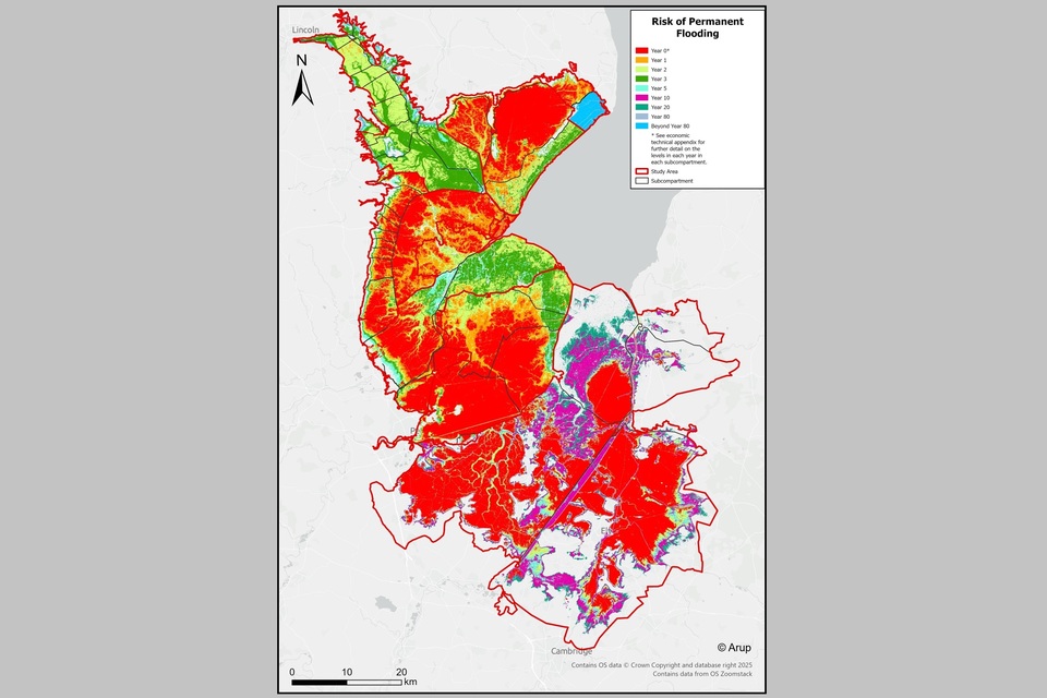
Image 10 - map showing the ‘Do Nothing Scenario, illustrating land at risk of permanent inundation if we stopped pumping and maintenance. Credit: Arup
13.3 Damages avoided by investment
If all flood risk management activities ceased (do nothing), flood damages across the Fens over the next 100 years would exceed £60 billion. £56.9 billion of this would occur in the first 10 years.
These damages are made up of:
- £7.9billion – agriculture – flooding to farmland will lead to immediate and long-term crop losses. Damages capture loss of crops and livestock and associated loss of profits. (Over 2,020 km2 / 202,073ha of arable land written off in the do nothing scenario).
- £36.6 billion – properties – captures the impacts of flooding on residential and non-residential buildings, through damage to building fabric and structure. (Over 99,000 residential properties written off in the do nothing scenario costing £28.4 billion. Over 29,000 non-residential properties written off in the do nothing scenario, costing £8.1 billion).
- £905.3 million – environment and recreation - loss of over 37km2 (3,700ha) of environmentally designated sites across the Fens will lead to losses of ecosystem services such as carbon sequestration, flood regulation, biodiversity, recreation and non-use values. Recreational damage would arise through loss of over 22km2 (2,200ha) of recreational sites and over 500km of public rights of way.
- £5 billion – utilities – captures the impacts of flooding to power, water supply, and gas networks. This includes damage to more than 6,700 substations, 22,000 pole towers, 100km of underground gas pipelines, and 450km of power cables
- £2.2 billion – isolated land - the consideration of isolated land and properties is unique to the do nothing scenario which considers permanent inundation of the catchment, rather than infrequent extreme flood events. It accounts for areas of land which may not be directly flooded, but are abandoned because flood waters cut-off the area from the existing road network.
- £8.1 billion – transport – the cost of the loss of road infrastructure, and railway network as a result of permanent flooding. This includes loss of over 260km of road infrastructure, costing £6.6 billion, loss of over 150km of rail infrastructure, costing £1.5 billion.
- £35.5 billion – losses to the local economy - losses to the local economy have been considered in terms of gross value added (GVA). This considers the cost to the local economy of over 188,000 jobs being lost across the Fens under a do nothing scenario. GVA is a local/ regional benefit so cannot be included in application for Grant in Aid funding.
- £217.5 million – heritage – cost of the loss or damage of over 400 heritage assets as a result of flooding. The catchment contains over 1,200 listed buildings and 100 scheduled monuments.
This split is summarised in image 11.

Image 11 - Pie-chart showing the split of damages avoided by investment. Credit: Arup
14. The benefits of investment
Current flood risk management assets maintain £58.8 billion of benefits. These include protecting:
- properties
- agriculture
- transport networks
14.1 What the economic benefit is of the current flood risk management assets
Living and working in the Fens is only possible because of the flood risk management and water level management assets. For example:
- pumping stations
- embanked defences
These assets provide £58.8 billion of benefits through avoided flood damages to:
- agriculture
- property
- transport infrastructure
- utilities
They also provide indirect benefits through:
- avoided losses to the local economy
- securing the rich natural capital assets across the Fens, worth £500 million
The investment needed to sustain the existing flood defences has been estimated at £6 to £9.4 billion. 50% of this investment is needed within 40 years. This does not include the investment needed to upgrade assets to increase their resilience to climate change.
These investment needs have been developed based on three types of assumed costs:
- ongoing and routine maintenance and operational costs
- infrequent asset refurbishment costs
- end of life asset replacement costs.
The costs have been developed based on data for various assets across the wider Fens 2100+ study area. These have been used to determine the average costs for each type of asset. They include:
- maintenance
- operation
- asset replacement
Asset refurbishment costs are only included where these have been provided for specific assets.
The range of costs reflects the uncertainty in the assumptions made at this stage. The analyses given within this report demonstrate the critical importance of a strategic plan for the future of flood risk management within the Fens.
The costs, impacts and management approach are illustrative of the scale and complexity of the investment challenge within the Fens. They provide a starting point for business cases and partnership development of future programmes and projects.
15. What the evidence tells us
15.1 Value built on legacy
The Fens landscape has been transformed by human influence. The scale of change has been so significant it required several acts of parliament. The legacy asset system we have today reflects past approaches to land drainage and flood risk management. These have been very successful in creating and maintaining a highly productive agricultural landscape and keeping people safe. The concentration of Grade 1 land means the agricultural value created here could not be offset somewhere else in the UK.
15.2 Critical infrastructure under pressure
This landscape value is enabled by more than 17,000 interconnected assets, managed by different organisations for many purposes. This means collaboration and shared understanding of the system is essential.
Many assets are outdated, built before modern engineering standards, and working at the limits of their capacity. Maintenance is often reactive and does not address increasing demands of future climate and land-use change. RMAs currently make difficult decisions about which maintenance activities to prioritise.
High-cost, high-risk assets remain underfunded. Budget constraints are preventing the kind of strategic renewal or rationalisation that could improve performance and reduce long-term costs.
Climate change will increase future risk. Increasing pressure will be placed on flood risk management assets to deliver the same Standard of Service in the face of:
- loss of gravity drainage
- compounding risks from sea level rise
- more frequent extreme weather events
Increased rainfall and storm events are expected to increase river flows by 4-21% by the 2080s. 1.1m of sea level rise is expected to cause an 8.5-fold increase in the area at risk of tidal flooding by 2125.
If essential flood risk assets fail, the consequences will be catastrophic, risking:
- lives
- land
- businesses
- infrastructure
Vast areas would become permanently inundated. Business as usual cannot support effective flood risk management.
15.3 Urgency
We must invest in asset maintenance and renewal now to secure the legacy value we already have. We need to plan for assets across the system which are nearing or have exceeded their foreseeable design life. The risk of cascading failures is growing as these assets degrade in parallel. By 2040, 31% of flood risk management assets will be beyond their foreseeable design life, reaching 89% by 2075. Around £6 to 9 billion of public and private investment is needed to sustain the current system for 100 years. And while we are investing to secure our existing assets, we must do so with the forethought of what is needed to upgrade systems. This includes:
- meeting growing climate change risks
- unlocking transformation across the landscape
- aligning with the SMP
16. Considerations for each catchment
The Catchment Baseline Reports reveal shared challenges, but indicate that effective solutions must take into account the distinct characteristics of each catchment.
16.1 Steeping
- The area at risk of tidal flooding will increase 10-fold under climate change.
- The embankments of the Wainfleet Relief Channel are vulnerable to overtopping during periods of high flow.
16.2 East and West Fens
- The area at risk of tidal flooding will grow 17-fold under climate change, affecting over 55% of the catchment, across prime Grade 1 and 2 agricultural land.
- Management of the increasing risk of tidal flooding should align with the SMP.
16.3 Lower Witham
- Projected increase in peak river flows of 21% by the 2080s, without plans for additional flood storage in place.
- 300km of embankment assets have medium to very high risk of failure, with 7% at very high risk of failure.
16.4 South Forty Foot Drain
- The catchment is divided into more than 25 pumped sub-catchments, with the smallest covering just 4km2 (400ha). There is potential to rationalise the number of pumping stations to reduce the number of assets which need to be inspected and maintained.
16.5 Lower Welland
- Peak river flows are projected to increase 17% by the 2080s.
- The Crowland and Cowbit Washes are currently under-utilised. There is potential to unlock greater volumes of flood storage to alleviate fluvial flood risk.
16.6 Lower Nene
- The current risk of tidal flooding is low, but a 30-fold increase in area at risk is projected under climate change.
- A decision about the future of Dog-in-a-Doublet Sluice is required now. The choice of location for the tidal limit will affect the wider asset system.
16.7 Great Ouse
- The Denver Sluice complex is critical for controlling water across the catchment and affects the security of King’s Lynn. All structures at the site need to be modernised, with better capability to monitor what is happening across the catchment in real time.
17. Glossary of terms and acronyms
Above Ordnance Datum (AOD)
The Ordnance Datum is the basis for all the land heights that appear on Ordnance Survey maps. It is essentially the mean sea level at Newlyn in Cornwall, and is sometimes called Ordnance Datum Newlyn (ODN).
Agricultural land Grades 1 and 2
Land classified as Grade 1, using the UK’s Agricultural Land Classification (ALC), has little or no limitations and will consistently achieve high yields for most crops. Grade 2 has reduced flexibility compared to Grade 1 and yields are generally high but can be more variable compared to Grade 1.
Agri-environmental schemes
Agri-environment schemes provide funding to farmers and land managers to farm in a way that supports biodiversity, enhances the landscape, and improves the quality of water, air and soil.
Assets
In the context of this report, assets refers to a structure built or created within the landscape and maintained specifically for water management purposes, for example embankments, sea walls, pumps and flood storage areas.
Asset Information Management System (AIMS)
A dataset with information about flood defence assets currently owned, managed and inspected by the Environment Agency.
Benefits
The positive quantifiable and unquantifiable changes that a flood risk management scheme is expected to produce, i.e. damages avoided.
Capital funding
Funding secured for the creation of new assets or the major refurbishment of existing assets to maintain or increase current standards of protection.
Carbon sequestration
The process of capturing and storing greenhouse gases from the atmosphere. In the context of natural systems this is via plant vegetation and soil processes.
Damages
The value of negative social, economic and environmental impacts caused by flooding.
Design life
Describes the original life expectancy of an asset at the time of its original design. This will be based on the standard of design applied to the asset.
Ecosystem services
Services provided by the natural environment which benefit people. They provide outcomes that provide positive benefits to human wellbeing.
Fens 2100+ study area
For the purposes of the Fens 2100+ Programme, the study area has been defined by land at or below the 6m AOD contour, which may differ slightly from the hydrological catchment.
Flood risk management assets
In the context of this report this refers to a structure built or created within the landscape and maintained specifically for water management purposes, for example embankments, sea walls, pumps, flood storage areas.
Main river
A statutory designation of watercourse, usually applied to larger streams and rivers. The Environment Agency have permissive powers to carry out maintenance, improvement and construction works on these watercourses, although usually the main responsibility for these lies with the riparian owner.
Maintenance funding
Funding secured for maintenance activities to existing assets to sustain the existing standard of protection. Sometimes this is referred to as revenue funding.
Mean High Water Spring (MHWS)
The average height of high-water level during spring tides, placing this area at risk of permanent inundation.
Natural capital
Refers to elements of the natural environment that provide valuable goods and services to people, underpinning wellbeing and economic prosperity.
Ordinary watercourse
Any watercourse which is not designated as a main river. Within the Fens the IDBs manage these watercourses on behalf of the riparian owners.
Resilience
The capacity for people and places to plan for, protect, respond to and positively recover from flooding and coastal change.
Shoreline management plan (SMP)
Shoreline management plans (SMPs) outline a strategic approach to managing flood and coastal erosion risks through to 2105. The Policy Development Zone (PDZ) of particular relevance to the Fens is PDZ1 Gibraltar Point to Wolfreton Creek, where the intention is to hold the position and function of existing coastal flood defences. In the medium and longer term, managed realignment may be required.
Standard of service (SoS)
Defined physical characteristics that a flood risk infrastructure asset is required to achieve. For example, the height of a protective barrier or throughput of a pump.