Exmouth tidal defence scheme
Updated 2 November 2022

© Crown copyright 2022
This publication is licensed under the terms of the Open Government Licence v3.0 except where otherwise stated. To view this licence, visit nationalarchives.gov.uk/doc/open-government-licence/version/3 or write to the Information Policy Team, The National Archives, Kew, London TW9 4DU, or email: psi@nationalarchives.gov.uk.
Where we have identified any third party copyright information you will need to obtain permission from the copyright holders concerned.
This publication is available at https://www.gov.uk/government/publications/exmouth-tidal-defence-scheme/exmouth-tidal-defence-scheme
The Exmouth tidal defence scheme is a £12 million scheme to improve flood defences in Exmouth. The scheme is now complete and has reduced the risk of tidal flooding to over 1,400 residential and 400 commercial properties.
The need for a new tidal defence scheme for Exmouth was initially identified as part of a flood risk management strategy for the whole of the Exe Estuary. The Environment Agency has been working in collaboration with East Devon District Council since 2015 to develop the scheme and the business case for funding; this culminated in approval of government funding in September 2017.
East Devon District Council has also contributed to the project, and will maintain the defences built on council-owned land.
Following analysis of possible flood scenarios for today, and in the future, it was recommended that Exmouth’s existing defences should be improved in the short term.
After gathering feedback from local public consultation in 2016, the Environment Agency concluded that flood risk should be reduced from the current 1-in-25-year risk (4% chance of flooding in any year) to 1-in-200-year (0.5% chance).
The impacts of climate change and sea level rise were included in the Environment Agency’s analysis.
The Environment Agency’s approach is to build defences that can be easily improved again in the future. Further tidal defence improvements should not be needed until 2045.
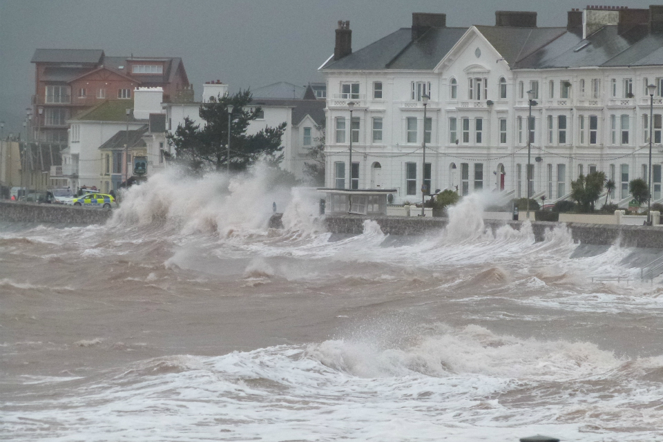
Wave lapping up against sea defences on Exmouth seafront in East Devon
The new scheme covers 3 areas:
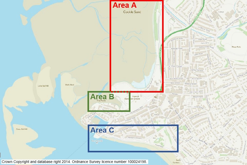
The 3 areas of Exmouth where new tidal defences have been built
- Area A – The Royal Avenue, on the estuary side of Exmouth. New flood defences have been built between the outfall of the Withycombe Brook and the Imperial Recreation Ground. The defences start as an earth embankment in the north, then become concrete walls around the Royal Avenue before they tie into the recreation ground.
- Area B – Camperdown Creek (around the ‘gut’). Raised defences have been built between the Imperial Recreation Ground and Camperdown Terrace. These works include a new earth embankment, a new timber-clad sheet-piled wall, upgraded rock gabions on the foreshore and a flood gate at the Camperdown Terrace slipway. A small flood ramp and property flood resilience work have also been built along Camperdown Terrace.
- Area C – involves the seafront, including the Esplanade from Mamhead slipway in the west, to between the clock tower and Premier Inn to the east. The new defences include improvements to the existing seawall toe and new set-back defences along the landward side of the Esplanade, including many new flood gates. This will mean that areas of the Esplanade and highway will still be inundated during storms, however flood water will be stopped from flowing down nearby roads by the new defences.
Design, consultation and planning phase
Planning permission for the Exmouth tidal defence scheme was granted by East Devon District Council, the local planning authority, in early January 2019.
Two specific areas of the project, Morton Crescent and Alexandra Terrace junction, were granted outline planning whilst details were confirmed there.
The reserved matters planning application for Morton Crescent was submitted on 13 March 2019. Full planning permission was granted on 11 June 2019, allowing access to this site for the construction of the new flood wall (on the line of the existing wall) as well as pedestrian flood gates and landscaping.
The reserved matters planning application for the new flood defences across Alexandra Terrace junction was submitted on 31 May 2019. Full planning permission was granted on 27 August 2019 for the installation of new flood walls and gates, and associated landscaping for the flood defence work.
The approved plans included a new setback flood wall and changes to the existing road layout where Alexandra Terrace meets the Esplanade. As well as providing benefits to reduce flooding, this more simplified road design also improves road safety. The planning application can be viewed on the council’s planning portal.
Contact
For further information please contact DCISEnquiries@environment-agency.gov.uk.