Byfleet and Weybridge flood alleviation scheme
Updated 22 July 2019

© Crown copyright 2019
This publication is licensed under the terms of the Open Government Licence v3.0 except where otherwise stated. To view this licence, visit nationalarchives.gov.uk/doc/open-government-licence/version/3 or write to the Information Policy Team, The National Archives, Kew, London TW9 4DU, or email: psi@nationalarchives.gov.uk.
Where we have identified any third party copyright information you will need to obtain permission from the copyright holders concerned.
This publication is available at https://www.gov.uk/government/publications/byfleet-and-weybridge-flood-alleviation-scheme/byfleet-and-weybridge-flood-alleviation-scheme
Background
Byfleet and Weybridge have experienced a number of notable flood events in 1968, 2000 and 2003. Recently, in 2013/14 prolonged heavy rainfall resulted in flooding from the River Wey and a total of 74 properties were flooded.
Following the most recent winter 2013/14 flood, the Environment Agency reviewed options to reduce flood risk at a number of locations in the Byfleet and Weybridge area and to see if any were viable to address flood risk.
The options
The Environment Agency have looked at a number of options, including:
- a permanent wall in the waterfront gardens of properties at Wey Road
- road raising and permanent defences protecting properties at Wey Meadows
- a combination of permanent flood walls, gates and embankments to protect properties in Byfleet at Brooklands Road, Viscount Gardens, Weymede and Weyside Close, Plough Bridge Farm and Parvis Road
- a combination of a permanent flood wall and embankment to protect the residential area around Sanway Road, Byfleet
- individual property-level protection (such as flood barriers on houses) in Byfleet and Weybridge
- upstream storage at seven locations in Weybridge and Byfleet
The appraisal has highlighted the Sanway area as the most viable option for Byfleet and Weybridge, providing the best value for money invested.
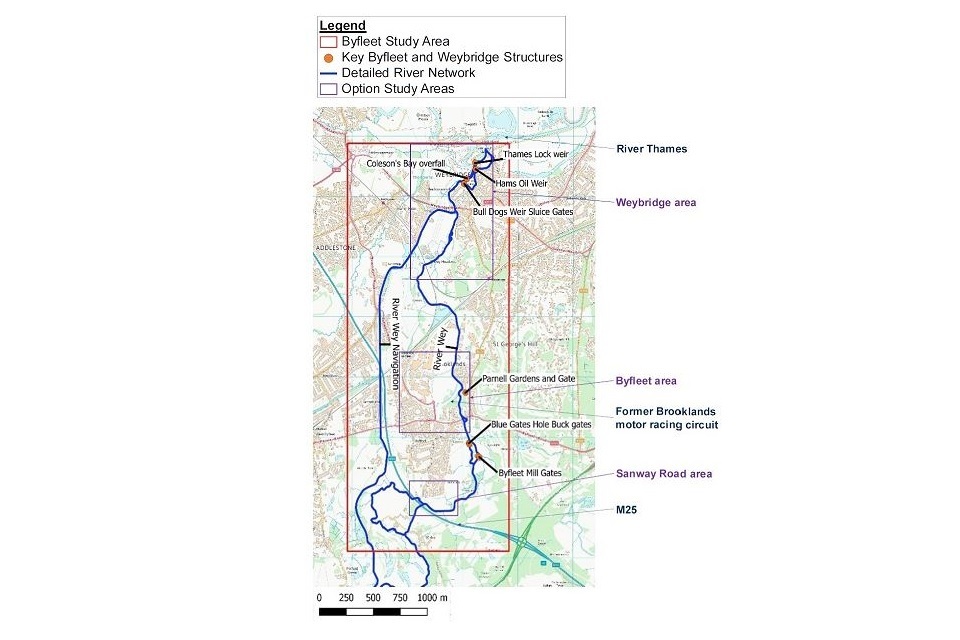
Weybridge and Byfleet project locations
Sanway area flood reduction proposals project
Visit the Sanway-Byfleet Flood Alleviation Scheme page for more information.
The flood defence alignments considered in the Sanway area include a combination of flood walls and flood embankments (permanent defences). The flood defence ranges from 0.3m to 2m in height depending on whether the land is low lying. The western end of the defence is tied into the M25 embankment next to Broad Ditch and runs east in Common Meadow along the rear boundary of properties in Fullerton Rd and Sanway area. The defence then runs northwards to protect properties in Summer Close before petering out on higher ground.
The figure below shows the Sanway area indicative alignment to give protection for a 1% Standard of Protection (that is, a 1% chance of flooding in any one year) taking into account the impact of climate change.
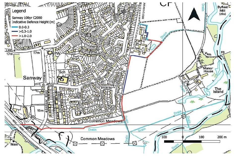
Sanway area indicative alignment
Since January 2019, the Environment Agency has been working with Woking Borough Council, Surrey County Council, Surrey Wildlife Trust, Highways England, Thames Water and the Byfleet Flood Forum to develop this scheme. They are carrying out computer modelling, and will design the scheme to reduce flooding to properties in the Sanway area. They will also make sure the floodwater is not pushed elsewhere and increase the risk of flooding for others. To offset the area of floodplain alleviated by the flood walls or embankments, compensatory flood storage will be provided close the scheme.
Indicative timescales
Over summer 2019, the Environment Agency will be developing a design for the flood wall, embankment and compensatory flood storage.
Once the preferred design option has been consulted on and then selected, there are various approvals that must be sought (including planning permission) before construction can begin.
Provided the scheme is fully approved and funded, the earliest construction can be expected to start is 2022.
Funding
Since 2010, there have been changes to the way the Environment Agency is able to secure funding for flood alleviation capital projects. The new approach requires partnership funding, meaning sufficient funds for the scheme have to be secured before the scheme can start developing detailed designs and construction.
The flood reduction proposals will use a mixture of funding from central government, Thames Regional Flood and Coastal Committee and local councils. But it still needs further contributions to enable construction. This is the standard way in which flood schemes are funded today.
Costs are not yet available yet as the team is still reviewing all of the options.
Get involved
The project team held two public information events in February 2019 to present the initial plans for the proposals to the local community. Further information events will be held in later in 2019 when there is new information to share.
The events will seek to gain useful local knowledge and understand the priorities of the local communities. The project team will use this information to help develop the scheme.
Contact us
For further information, or to provide feedback please email: THM.schemes@environment-agency.gov.uk.