Bridgwater tidal barrier scheme
Published 30 March 2026
Applies to England

© Crown copyright 2026
This publication is licensed under the terms of the Open Government Licence v3.0 except where otherwise stated. To view this licence, visit nationalarchives.gov.uk/doc/open-government-licence/version/3 or write to the Information Policy Team, The National Archives, Kew, London TW9 4DU, or email: psi@nationalarchives.gov.uk.
Where we have identified any third party copyright information you will need to obtain permission from the copyright holders concerned.
This publication is available at https://www.gov.uk/government/publications/bridgwater-tidal-barrier-scheme/bridgwater-tidal-barrier-scheme
1. Background
Bridgwater, in Somerset, lies on the River Parrett estuary, 17 km upstream of the Severn Estuary. Much of the town and surrounding areas are below tide level. This means tidal flooding is a risk for:
- 11,300 homes
- 1,500 businesses
- critical infrastructure
High tides and storm surges can quickly flood low‑lying areas, sending water inland with little warning.
2. The scheme
The Bridgwater Tidal Barrier (BTB) scheme is an initiative aimed at reducing this flood risk through a tidal surge barrier and downstream defences. It is designed with a 100-year lifespan, and seeks to:
- create an environmental corridor, including wetlands and heritage features
- connect both sides of the river
- support sustainable growth in Bridgwater, boosting community resilience and business confidence
The scheme is led by the Environment Agency and Somerset Council. It forms part of Somerset’s 20-year Action Plan, accelerated after the severe 2013 to 2014 floods. These floods were caused by prolonged rainfall and high tides. They devastated homes, agriculture, and infrastructure and highlighted the need for robust flood defences.
The primary objective of the BTB scheme is to reduce tidal flood risk. It will do this through the construction of a tidal surge barrier and associated downstream defences.
The BTB scheme will provide a 1-in-200-year standard of protection for 12,800 homes and businesses. This level of protection will extend to 2125 for Bridgwater. It will also benefit the downstream communities of:
- Combwich
- Chilton Trinity
- Pawlett
Some sections of flood bank will need raising around 2055.
The scheme comprises 3 major workstreams:
- the tidal barrier
- downstream flood defences
- fish and eel passes
2.1 The tidal barrier
The barrier will be a large gate structure across the River Parrett between Express Park and Chilton Trinity. This will prevent the tide travelling upstream and overtopping defences and flooding property and infrastructure.

Image 1: Jack up barge in the River Parrett. Image courtesy of the Environment Agency.
The barrier will comprise of 3 towers;
- one on each bank
- one in-channel supporting two 15 metre wide vertical lift gates
The 3 towers will be around 15m high and 6.3m wide.
When not in use, the 2 vertical lift gates will be raised out of the water and will only be closed on exceptional high tides. Two high-level cross bridges will provide maintenance access between the towers at roof level. The lifting equipment, such as winches, will be situated within the base of the towers at ground level.
There will be a pedestrian and cycleway bridge that crosses the river on the upstream side of the barrier.
2.2 Downstream flood defences
Downstream flood defences are a critical part of the BTB scheme. They will work alongside the barrier to protect communities and infrastructure from tidal surges. These embankments provide long-term flood resilience for:
- Combwich
- Chilton Trinity
- Pawlett
- major transport routes, including the A38 and railway line
To build the new and improved embankments, the project team is using material excavated from local borrow pits in Chilton Trinity, Pawlett and Combwich.
This:
- reduces the need for importing material
- cuts down on heavy goods vehicle (HGV) movements
- supports a more sustainable approach to construction
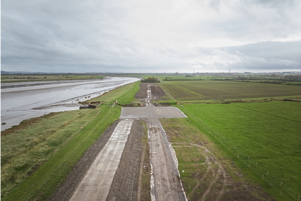
Image 2: Combwich piling matting. Image courtesy of Environment Agency.
The scheme is also reusing materials from temporary works wherever possible. Once no longer required, the borrow pits will be restored as wetland habitats. This will create long-term ecological enhancements alongside the engineering benefits.
To minimise local disruption, dedicated haul roads and gated access routes have been created to limit construction vehicles using village roads. These arrangements are supported by detailed Construction Noise and Vibration Management Plans (CNVMP). These will be approved by the local planning authority for each phase of work.
2.3 Fish and eel passes
As part of the BTB scheme, we are delivering improvements to up to 12 fish and eel passes across the Rivers Parrett and Tone. These upgrades will help migratory species reach the habitats they depend on to thrive.
We are delivering these passes in a phased programme, aligned with the construction of the tidal barrier and downstream defences. Although the barrier will only begin to significantly affect fish migration from around 2055, we are introducing these improvements earlier. This will:
- maximise ecological benefit
- ensure healthy, resilient fish populations well into the future
Our priority remains the long-term health of the river system. We aim to improve connectivity, biodiversity, and habitat quality for decades to come.
3. Investment and funding
The cost to build the scheme includes:
- the barrier and its operating buildings
- new and improved downstream flood defence banks
- improved fish and eel passage at up to 12 upstream sites
Funding for the BTB scheme comes from a partnership of national, regional and local sources.
These include:
- Defra FCERM Grant-in-Aid (FCERM GiA)
- other Government Department contributions
- Environment Agency
- Somerset Council (via the Community Infrastructure Levy, Section 106 agreements and Town Deal funding)
- Heart of the South West Local Enterprise Partnership (LEP)
- Wessex Regional Flood and Coastal Committee (local levy)
- Somerset Rivers Authority
- Department for Education
- Wildfowl and Wetlands Trust
This reflects the scheme’s importance for:
- flood risk reduction
- economic growth
- national resilience
Partnership funding totals £91 million. The remaining funding required to complete the scheme will be provided through FCERM GiA.
A large proportion of Somerset Council’s contribution comes from developer funding secured through the planning process. This is done through:
- section 106 agreements
- community infrastructure levy
These contributions are collected by the local planning authority. They are allocated to essential infrastructure, including flood defences, where required to support safe and sustainable development.
This partnership funding approach is typical for major flood risk management schemes. It helps ensure public funding is used responsibly to deliver long-term benefits for communities.
The previously published figure of £249 million reflects the baseline business case approved in 2024. The scheme continues with an active construction programme.
4. Design efficiency review
The BTB scheme is currently undergoing a ‘design efficiency review’. The Environment Agency’s review has enabled the BTB scheme to be refined. This helps to:
- mitigate cost increases
- reduce construction and maintenance costs
- simplify operations
- maintain the agreed outcomes and benefits
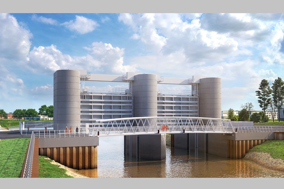
Image 3: Concept design of the Bridgwater tidal barrier scheme. Image courtesy of the Environment Agency.
While the review has considered the whole scheme, its main focus has been on the tidal barrier superstructure. This process has included assessing alternative design approaches and newer technologies. These will make sure the scheme can still achieve the same outcomes but more efficiently.
The review is ongoing. Alongside the barrier design changes, additional areas of cost refinement such as the operational building and landscape design are under assessment. The review will run alongside the live programme, incorporating agreed design changes to avoid unnecessary delay.
We anticipate being on site for another 5 to 6 years. This timescale includes additional landscaping elements that are part of the wider design of the scheme. The priority is to make the barrier operational, so flood protection is available to Bridgwater and the surrounding areas as soon as possible.
You can visit the Somerset Council website for more information on the Design Efficiency Review.
5. Partnership
The BTB scheme is led by:
- the Environment Agency
- Somerset Council
6. Progress: 2025 to 2026
Enabling work started on site in 2023. Work on the barrier foundations, existing downstream defence and new embankments in Chilton Trinity, Pawlett and Combwich progressed rapidly throughout 2025.
The temporary bypass channel is now open and flowing, enabling in-channel construction to begin. The jack-up barge has been repositioned in the River Parrett to support construction of the central cofferdam, where the 3 barrier towers will be built. Piling of the east cofferdam is complete and ready for the temporary tension slab concrete pour.
Work across all 3 areas of the downstream defences includes the:
- construction of primary and secondary embankments
- completion of haul roads
- excavation of the largest borrow bit in Chilton Trinity with 60,000 meters cubed (m3) of material being excavated to for embankments for the scheme
We will:
- complete the ongoing archaeological excavation and investigations in Pawlett, in the first quarter of 2026
- install 600m piling mats in Chilton Trinity in readiness for seepage cut off wall sheet piling in Spring 2026
- install 4 permanent culverts and continue construction of the secondary embankment in Combwich in Spring 2026 - work will recommence in the area following demobilisation during the winter months
7. More information
Find out more about the Bridgwater tidal barrier scheme.
You can ask our project team about the works or join our electronic distribution list for future updates and newsletters by bridgwater.barrier@environment-agency.gov.uk
You can also follow us on: