Assess relevance of Geospatial data
Updated 25 August 2020

© Crown copyright 2020
This publication is licensed under the terms of the Open Government Licence v3.0 except where otherwise stated. To view this licence, visit nationalarchives.gov.uk/doc/open-government-licence/version/3 or write to the Information Policy Team, The National Archives, Kew, London TW9 4DU, or email: psi@nationalarchives.gov.uk.
Where we have identified any third party copyright information you will need to obtain permission from the copyright holders concerned.
This publication is available at https://www.gov.uk/government/publications/assess-relevance-of-geospatial-data/assess-relevance-of-geospatial-data
1. Introduction
In a world overloaded with data, how do users know what data to trust and whether it’s the best suited for their needs? One of the recommendations from our first Data Discoverability project was to assess data publishers and their geospatial datasets against standard criteria to determine the levels of trust and confidence associated with any given dataset. It is hoped that communication of these results will help users find appropriate geospatial data from trusted providers and build their confidence when using geospatial data.
2. What we did
Geospatial Glossary: First and foremost, everyone needs to speak the same language. We produced a glossary of geospatial terms to promote consistency and enable a common understanding of some of the key terminology used by the Geo6 organisations. This is designed to help make the geospatial sector more accessible and user friendly for entry-level users.
Authoritative Data Assessment Process and Tool (ods, 186 KB): To identify, and subsequently help users find officially recognised data of appropriate quality provided by trustworthy organisations, we developed a process to consistently identify and assess geospatial datasets. This is based on the publisher’s trustworthiness and their overall confidence in a geospatial dataset. We developed an assessment tool to implement this process in Microsoft Excel to apply the process to datasets earmarked for publication. The images below are extracts of the tool.
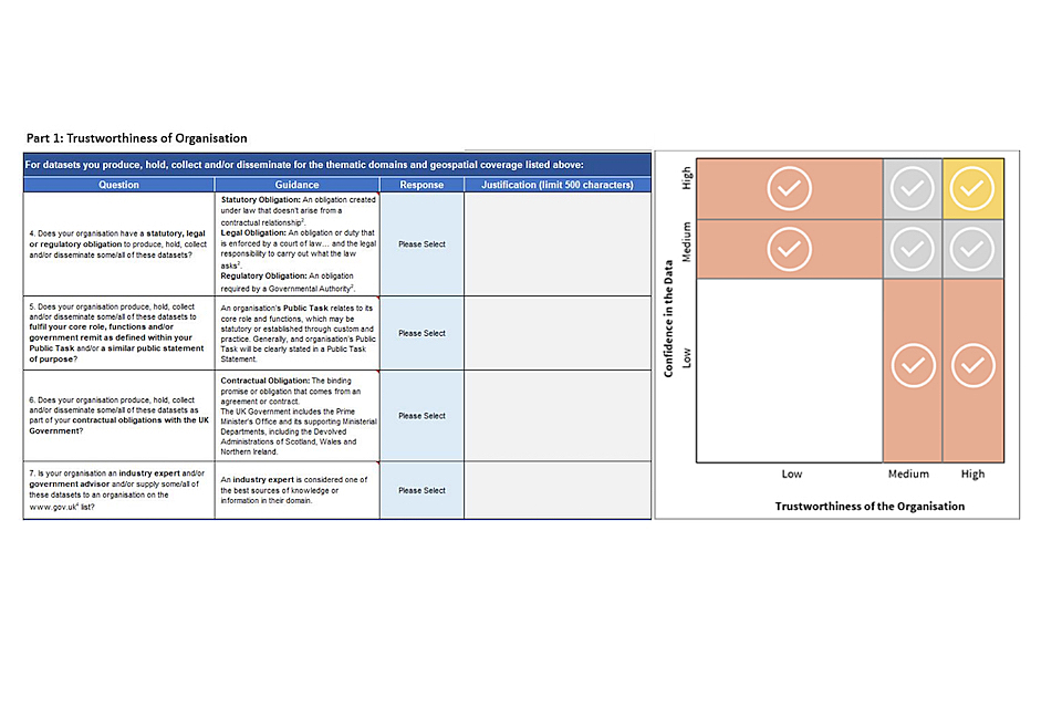
extract of images from our Authoritative Data Assessment tool
The Assessment Process consists of two parts:
Part 1: Trustworthiness of the Organisation
This section assesses the overall trustworthiness of the organisation producing the dataset. It includes questions on:
- the ‘authority’ or remit of the organisation;
- the thematic domains and geographical areas for which they publish geospatial data; and
- their data management, and metadata policies and practices.
Part 2: Confidence in the Data This section assesses the overall confidence the organisation has in the geospatial dataset under assessment. It considers whether a geospatial dataset falls within the overall authoritative remit of its data publisher, as identified in Part 1 of the assessment, and also assesses its overall quality, associated metadata, and capture and maintenance processes.
3. Recommendations
- Continued review and testing of the Authoritative Process by a wider group of organisations during a Beta Phase of development. The Beta Phase and development should focus on:
- testing and comparison between how a wider range of organisations view themselves and their datasets;
- user testing of the results and rankings with a wider audience to see if the Assessment Process produces useful rankings;
- user testing of potential presentation of the results in a portal environment, for example data.gov.uk; and
- initial testing of proposed governance process and ways of working.
2.Create maintained registers of geospatial data publishers, and of assessed and certified geospatial datasets.
3.Communicate assessment results on data.gov.uk to improve the overall discoverability of authoritative geospatial datasets.
- Visual icons search results: We recommend that the results of the assessment process are displayed alongside the dataset’s title on data.gov.uk. This should be in the form of a gold, silver or bronze tick icon which represents the combined scores of Part 1 and Part 2 of the Assessment.
- Additional information: Research showed that data stewards and managers wanted a more detailed breakdown of the assessment results to enable comparison and differentiation between low confidence datasets published by trustworthy organisations and high confidence datasets published by less trustworthy data publishers. More detailed results should be made available in the dataset’s metadata.
- Search rankings: To further assist users when searching for reliable or trustworthy geospatial datasets, those that have been assessed and achieved a gold, silver or bronze rating, should be boosted in search rankings to ensure these are displayed on page one of any results returned.
- Additional filters: To further assist users when searching for authoritative geospatial datasets, additional filtering capability is required on data.gov.uk. These should include the ability to filter firstly by region and secondly by assessment rating.
4. Benefits
- A standard glossary of terms, pitched at the entry-level user, will promote better understanding and ensure everyone speaks the same language.
- The tool can also be used by those searching for data to assess its ‘authoritativeness’.
- Ultimately, it will be easier for users to find information they can trust in Geospatial Data Catalogues