Weather Radar deployed in Cumbria to improve flood forecasting
The Environment Agency and the National Centre for Atmospheric Science (NCAS) have successfully deployed a mobile weather radar in Cumbria.
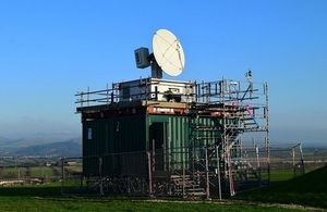
X-Band Weather Detector Radar
The Environment Agency and the National Centre for Atmospheric Science (NCAS) have successfully deployed a mobile weather radar in Cumbria. For the next 12 months, the NCAS X-band radar will provide data that will help improve the Environment Agency’s rainfall detection capability and should lead to an improvement in our flood forecasting and warning services.
The deployment is a collaborative research project between the Environment Agency, the University of Leeds and the National Centre for Atmospheric Science, called Radar Applications in Northern England (RAIN-E).
The radar will be used to:
-
Improve the weather radar coverage in north Cumbria for up to a year
-
Provide information to support the development of a long term weather solution for Cumbria
-
Further understand the challenges associated with collecting high quality data over mountainous terrain
-
Learn more about bringing multiple sources of rainfall data into the national weather radar
Weather radars are the most effective way to collect real-time rainfall information and NCAS operates the only mobile weather radar in the UK. The radar measures rain, wind and other parameters. Importantly, the location of the radar will improve the observations of rainfall over Cumbria, helping to make flood forecasting in the area more accurate.
Data collected by the radar will provide evidence for the need to invest in a permanent solution and help researchers better understand the type of extreme rainfall that sometimes affects Cumbria.
A separate partnership project between the Environment Agency, Met Office, National Resources Wales, Scottish Environment Protection Agency and Department of Infrastructure Northern Ireland is developing a national strategy for the UK’s radar network over the next 15 years and data from the radar will help to support the development of a long term radar solution in Cumbria.
Tim Harrison, Senior Advisor for the Environment Agency said:
The deployment of the NCAS radar will help us to build a strong case for investment where it’s needed. We’re seeing many benefits from the collaboration including a greater interest from all parties to integrate data from deployments like this, and other third party radars into the national Met Office rainfall products.
Ryan Neely and Lindsay Bennett, scientists at the National Centre for Atmospheric Science added:
We are happy to be working with the Environment Agency to provide them with high resolution data in this under-observed region so that they may improve their flood forecasts. For NCAS, we are excited to make observations in a new region that will allow us to explore many scientific questions about the rainfall processes in mountainous terrain.
Notes to Editors:
Radar Applications in Northern England (RAINE) data collected by the NCAS X-band radar in Cumbria is available for researchers and members of the public to view.
The latest data and more information about the research agreement is available on the Cumbria weather radar website.
The National Centre for Atmospheric Science (NCAS) is a world-leading research centre dedicated to the advancement of atmospheric science, and is funded by the Natural Environment Research Council.
For media enquiries please contact the press office on 0800 917 9252. For out of hours please call 0800 028 1989 and ask for the duty press officer.