Plans submitted for a new ‘aquagreen’ to reduce flooding in east Hull
Plans to create a large ‘aquagreen’ to reduce flood risk to homes and businesses near Bransholme in east Hull have been submitted for planning approval.
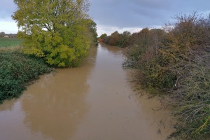
Flood water in Holderness Drain, November 2019.. Credit: Hull City Council
A public consultation was launched in September 2020 on proposals for a versatile green space, south of the old Bransholme Dairy Farm, that will store excess water during a flood and then slowly release it back into the drainage system after the peak of the flood has passed.
Now that feedback from the community and partners has been considered, plans have been revised and submitted to Hull City Council and East Riding of Yorkshire Council for approval.
Homes in North Carr and Sutton are currently at risk of flooding from water in the Holderness and Sutton Cross drains after heavy rain. The Holderness Drain is a man-made river channel. When it becomes full, water flows into Sutton Cross Drain, overwhelming the local drainage system and increasing the risk of flooding for homes in the area. This area almost flooded in November 2019 when other parts of Hull were hit.
If approved, the ‘aquagreen’ will be the second phase of the £28.5m Holderness Drain Flood Alleviation Scheme, following construction of the new East Hull Pumping Station, which started earlier last year.
Andrew Barron, Environment Agency flood risk advisor for Hull, said:
Last year’s consultation was a really useful opportunity to talk to the community to get their local knowledge to help influence and improve our proposals for Castlehill.
We are now in a position to submit our final plans for this scheme, which will significantly reduce the likelihood of flooding for properties in the North Carr and Sutton areas of Hull by storing flood water in the aquagreen.
Under normal weather conditions, the site will not hold water which gives us an ideal opportunity to create a more attractive green space that people can enjoy spending time in.
Councillor Mike Thompson, portfolio holder for Neighbourhoods, Community and the Environment at Hull City Council, said:
It is exciting and I’m proud to see this phase of the Holderness Drain FAS progressing to the next stage. The scheme offers not just a reduction in flood risk, but also helps the city adapt to the increasing challenges of climate change and provides more reassurance to families.
The scheme will also provide local people with more opportunities for walking and enjoying the outdoor environment, an element that has become so important to us all in the last year, and the value this brings in terms of our health and wellbeing shows that we need to take greater care of our natural environment.
Councillor Chris Matthews, portfolio holder for strategic property and infrastructure at East Riding of Yorkshire Council, said:
Any scheme which reduces the risk of flooding and helps to take on the challenges of climate change can only be a good thing for the East Riding and our residents.
The East Riding already has a lot of green areas which allow for outdoor exercise and socialising so we very much would welcome the opportunity to step forward with the ‘aquagreen’ project.
James Leeming, Senior Project Manager at Highways England, said:
This is an important step forward for the ‘aquagreen’ project. Keeping our roads flowing freely and protecting the communities who live alongside them is vitally important. That’s why we are working closely with our partners along the A63 route and providing £5 million towards the continued success of the Holderness Drain Flood Alleviation Scheme.
Stephen Parnaby OBE, Chair of the Humber LEP, said:
We are thrilled this important project to help protect homes and businesses from the risk of flooding in Hull and East Yorkshire is progressing and plans have now been submitted. We are pleased to support the Castlehill Aquagreen through our allocation of the Local Growth Fund.
The construction of the ‘aquagreen’ will involve digging an extra drain, east of Sutton Cross Drain, building a new embankment beside it and digging a long wide ditch at the southern end of the site to increase the capacity for temporarily storing water during a flood.
Once a flood is over, most of the water will drain away although the site is designed to remain wet in some areas. As part of the plans, several low spots will be raised on both sides of the Holderness Drain to reduce the risk of flood water spilling out onto the land next to the drain.
Proposals for the site also include:
- improving access and creating a network of paths and bridleways
- creating a range of different habitats for wildlife including woodland, hay meadow, scrubland, reed beds and small ponds
- offering better protection for the Castle Hill monument and installing information boards about its history
Findings from the public consultation were analysed and resulted in several changes to the scheme. A proposed footbridge between Bransholme Estate and the Castlehill site has been removed due to concerns raised during the consultation around security and more barriers have been included in the scheme to prevent motorbikes gaining access to the site.
This partnership scheme, led by the Environment Agency and supported by Hull City Council, East Riding of Yorkshire Council, Highways England and the Humber Local Enterprise Partnership’s Local Growth Fund Programme, will better protect around 1,000 properties and help to provide a long-term, more sustainable solution to the problem of flooding in this area. The Humber Local Enterprise Partnership secured £2.14 million towards the project through the Local Growth Fund as part of the Government’s commitment to the Northern Powerhouse.
The plans are available online to view and comment on.
You can read a more detailed description of the changes to the plans in the full report, which can be downloaded from the Holderness Drain website.
If residents have any questions they can email the project team at: HoldernessdrainFAS@environment-agency.gov.uk