New radon map for Northern Ireland published
Households across Northern Ireland are being encouraged to test for radon gas, as a new map has highlighted further at-risk areas.
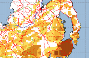
Sample radon map of Northern Ireland
Radon is a naturally occurring radioactive gas that seeps into homes from the ground. Long term exposure can lead to cancer and it is estimated that every year there are about 1,000 radon linked lung cancer deaths in the UK. However there are practical measures that can be taken to substantially cut the level of radon exposure.
Radiation experts at Public Health England and the British Geological Survey, using geological information from the Geological Survey of Northern Ireland and radon measurements, including many made with support from the Northern Ireland Environment Agency, are today publishing a new map for Northern Ireland, which has increased the total number of homes at-risk.
Neil McColl, head of radon at Public Health England’s Centre for Radiation, Chemical and Environmental Hazards, said:
We estimate some 155,000 homes, about 1 in 5 in Northern Ireland, are now in ‘Affected Areas’: these are places where some householders are exposed to radon at a level where we recommend protective action.
This is an increase on the last estimate we made of the total number of Northern Ireland homes at risk. Of course few will have radon at a level that requires attention, but there will be some.
There are definite health risks from radon, particularly if you’re a smoker or an ex-smoker, so we want people to take this seriously and think, especially if they’re in an affected area, about what steps they should take.
The last radon map of Northern Ireland, published in 2009, identified about 90,000 homes being at risk from higher levels of radon. The new map combines thousands of radon measurements with detailed geological information to produce a more accurate map.
Dr Kate Royse, Science Director for Environmental Modelling at the British Geological Survey said:
Our unique collaboration brings together an understanding of radon in the rocks with household radon measurements enabling us to produce a much more accurate radon map for Northern Ireland. This will help to increase the awareness of radon gas emissions in Northern Ireland and enable those homes affected by high radon values to take simple steps to reduce their exposure.
Dr Mark Cooper, Chief Geologist for Northern Ireland at the Geological Survey of Northern Ireland said:
The arrangement of geology across Northern Ireland is such that rock types that are more prone to radon production, such as granite, limestone and mudstone, occur mainly in the southeast and west.
The areas more widely affected are: Newry, Mourne and Down in the south east, Londonderry and Strabane in the north west and Fermanagh and Omagh in the south west.
Dr Gerry Waldron, Consultant in Health Protection at the Public Health Agency in Northern Ireland, said:
You won’t know if your home has a high level of radon unless you test, so we’re urging people to have a look at our new map, find if their home is an affected area and if so get a test. Testing is easy, it is not intrusive and there are plenty of websites online where you can order a radon test.
It’s not only homes where radon is an issue. Although we all get our greatest exposure at home, because it’s where we spend most of our time, employers have responsibilities under health and safety laws to protect their staff. So it’s important they look at the new maps too so they can see if their workplace is at risk.
For more information about the practical measures that can reduce radon exposure and to view the maps visit www.ukradon.org.
Background
Scientists are available for interview. Please contact the PHE press office on 01235 825406/405.
For more information on radon visit www.ukradon.org.
Public Health England is the adviser to all arms of the UK Government, including the devolved administrations of Scotland, Northern Ireland and Wales on the public health effects of radiation.
The Public Health Agency is Northern Ireland’s regional organisation for health protection and health improvement. It is a multi-disciplinary, multi-professional body with a strong regional and local presence. It has four key functions:
- health and social wellbeing improvement
- health protection
- public health support to commissioning and policy development
- HSC research and development
It was set up to provide a renewed and enhanced focus on public health and wellbeing by bringing together a wide range of public health functions under one organisation.
The British Geological Survey (BGS), a component body of the Natural Environment Research Council (NERC), is the nation’s principal supplier of objective, impartial and up-to-date geological expertise and information for decision making for governmental, commercial and individual users. The BGS maintains and develops the nation’s understanding of its geology to improve policy making, enhance national wealth and reduce risk. It also collaborates with the national and international scientific community in carrying out research in strategic areas, including energy and natural resources, our vulnerability to environmental change and hazards, and our general knowledge of the Earth system. More about the BGS can be found at www.bgs.ac.uk.
UK Health Security Agency press office
10 South Colonnade
London
E14 4PU
Image © Crown copyright and British Geological Survey © NERC 2015