Free satellite data to help tackle public sector challenges
Government departments, emergency services and local authorities will receive free access to thousands of high-resolution satellite images of Britain, under plans announced today by Science Minister Sam Gyimah.

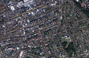
Satellite image overlaid with pavement widths in metres used as part of a project to identify suitable places for electric vehicle charging points. Credit: Energeo Ltd.
The UK Space Agency’s Space for Smarter Government Programme (SSGP) will provide access to archives of images and radar data for research and development projects.
This will stimulate further growth in the UK’s world-leading space industry, which already employs around 40,000 people, while benefitting the public sector in areas such as planning and development.
The images will provide an unprecedented level of detail of major British cities, transport networks, national parks and energy infrastructure.
This type of satellite data is already being used in a number of pilot projects. It has been combined with machine learning techniques to help Bournemouth Borough Council identify the best locations for electric vehicle charge points across the city. While the Environment Agency is investigating the feasibility of using satellite images as a tool to monitor plastic pollution off Britain’s shoreline to support clean-up operations and protect wildlife.
With a vast amount of new images now available for free, there is significant potential for further innovations.
Science Minister Sam Gyimah said:
From monitoring plastic pollution to supporting the next generation of electric vehicles, satellite imaging is transforming our society from the skies.
This is a great example of how our modern Industrial Strategy’s support for our thriving space sector is spurring innovation, driving growth and further strengthening public services.
There is expected to be high demand for the images which offer sub 5m resolution with less than 15% cloud cover, for public sector research and development.
Sara Huntingdon, the UK Space Agency’s SSGP Manager, said:
Until now there has been a perceived financial barrier to the public sector, academics and start-ups accessing high resolution data from satellites, so this is great news for the UK space sector.
We hope it will break down barriers, enable rapid prototyping and stimulate the next wave of satellite enabled application development. We are trying something that has not been done before across the whole UK Government, and I am really excited to see the results.
The images have been procured from Airbus Defence and Space and Telespazio-Vega UK Ltd. Airbus are providing high resolution optical imagery, effectively a colour camera in space, from its Spot and Pleiades satellites.
Phil Brownnett of Airbus, Intelligence (UK) said:
Airbus is delighted to be working with the Space Agency to provide access to our accurate, up to date satellite imagery of the UK. We fully believe that this initiative will stimulate growth in space services and applications across government.
Telespazio VEGA UK are providing high resolution Synthetic Aperture Radar (SAR) data collected by the four-satellite COSMO-SkyMed constellation. Imaging radars on board the satellites transmit and then receive radar signals that are able to penetrate cloud cover and provide images of the Earth’s surface day and night.
Michael Lawrence, Head of Marketing and Sales at Telespazio VEGA UK, said:
Analysis of the additional information provided by high resolution SAR data will allow the measurement of ground displacements and identify the precise location of changes to both the urban and natural environment.
The data will be available for up to three years to explore what role high resolution satellite data could have in public sector delivery. The project will also feed in to the recently established Geospatial Commission, set up by the government to maximise the value of all UK government data linked to location, and to create jobs and growth.
Simon Agass, from the Satellite Applications Catapult, which is working with the UK Space Agency to deliver this project, said:
This could be transformational for government services in the UK and ultimately provide a platform for the export of satellite derived services for governments across the globe
Providing the public sector with this satellite data is an example of the government fully exploiting the power of technology and data to deliver world-class services. The #SmarterGov campaign has been launched to drive innovation, savings and public service improvement across the public sector.