Essential Somerset reservoirs upgraded to prevent flooding
The Environment Agency has made major maintenance upgrades to three flood storage reservoirs across the Somerset Levels and Moors.

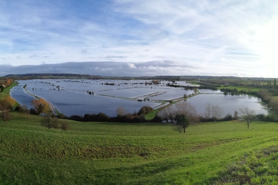
West Moor Reservoir and the village of Thorney
The Environment Agency has announced the completion of major maintenance investments to essential flood storage areas across the Somerset Levels and Moors, as part of a £90 million capital investment programme to continue protecting communities from flooding.
The programme of works, which began on site in 2022, has strengthened resilience to flooding at three key sites: West Moor, Curry Moor, and Southlake Moor Reservoirs. This maintenance will help manage resilience to flooding for villages, farms, and major transport routes including the A361 Taunton-Glastonbury trunk road.
The Somerset Levels and Moors face unique flooding challenges, with 18% of Somerset lying below average tide level. The upgraded flood storage areas form part of an interconnected floodwater management system, meaning improvements to individual sites strengthen the resilience of the entire network.
Millions invested into flooding
Southlake Reservoir view from Burrow Mump
The Environment Agency is investing tens of millions in maintaining the flood storage areas in the Somerset Levels and Moors.
This investment into capital maintenance is funded through the Government’s £5.2 billion programme investment to protect 336,000 properties from flooding and coastal erosion by 2027, recognising the vulnerability of this low-lying region which extends over 60,000 hectares, equivalent to over 84,000 standard football pitches.
These flood storage areas were built in partnership by construction company Kier.
Located approximately 3.5km south of Langport, West Moor Reservoir has undergone substantial improvements, including the replacement of a connecting pipe between the two moors and construction of a new outlet spillway from South Moor and a new inlet and outlet spillway at West Moor.
These improvements help protect Thorney village and surrounding areas during periods of high-water levels, when the area stores 8.5 million cubic metres of water from the wider catchment – the equivalent of the volume of 3,400 Olympic swimming pools. With favourable conditions, current planned completion of works is now programmed for October 2026.
At Curry Moor Reservoir, located 9km west of Langport, improvements have included the installation of a debris screen, bank repairs, and the completion of critical embankment and spillway works along a 200-metre section of the River Tone between Hook Bridge, and New Bridge. These works, scheduled to finish in 2026, will protect local farms, settlements, and the vital A361 transport link.
Southlake Moor Reservoir has seen significant strengthening of the right bank of the River Parrett and reinstatement of the left bank of the River Sowy. A new spillway for preferential overflow in and out of the moor has been constructed, with additional perimeter works planned for April 2026.

Construction of one end of the connecting pipe for West and South Moor reservoirs
Ian Withers, Wessex Area Director, Environment Agency, said:
These vital maintenance investments represent a significant step forward in continuing to protect Somerset communities from flooding.
The £90 million investment demonstrates our commitment to building resilience across the Somerset Levels and Moors, an area we know has a unique and persistent flood risk due to its geography.
By strengthening these essential flood storage reservoirs, we’re not only protecting homes and businesses today but ensuring these communities are better prepared for future flood events. The interconnected nature of our flood cell system in low-lying Somerset catchments means these maintenance investments benefit a much wider area.
Jason Flagg, Catchment Engineer for Wessex West reservoir projects, Environment Agency, said:
The technical complexity of these reservoir upgrades has been immense, but the engineering solutions we’ve implemented will make a real difference when communities are most at risk.
From the new spillway systems at West Moor and South Moor to the comprehensive bank reinforcement at Southlake, every element has been designed to work as part of the wider flood management network.
We’ve also ensured our work protects the local environment – our careful approach to preserving wildlife habitats, including the reed canary-grass stands that support rare species, as well as conservation of archaeological finds, shows that effective flood defence and environmental protection can go hand in hand. These reservoirs are now in a strengthened condition to serve communities for decades to come.
The Somerset Levels and Moors have a long history of flooding, with records dating back to the 1600s and significant recent events in 2014, 2012, 2000, 1997, 1960, and 1929. The 2014 floods particularly affected the Parrett and Tone River catchments.
Protection of nature

Currymoor Reservoir with Athelney spillway overflowing near King Alfred’s monument
Comprehensive environmental protection measures were implemented throughout the reservoir upgrades to safeguard local wildlife, through collaboration with Natural England.
At Southlake Reservoir, bat surveys preceded all works at Burrow Wall, while West Moor required the careful relocation of fish across eight watercourses during summer 2023 to enable construction access.
At Curry Moor, teams created a new artificial badger sett to replace one affected by River Tone embankment works and conducted specialist water vole detection dog surveys to ensure no disturbance to these protected species or their burrows.
Field teams have also taken special measures to protect reed canary-grass stands along the River Tone, preserving the habitat for hairy click beetle larvae.
The work balanced essential flood protection with preserving the rich biodiversity of the Somerset Levels and Moors.
Notes to Editors
-
The Somerset Levels and Moors consist of ‘The Levels’ (the higher coastal clay belt) and the ‘Moors’ (the low-lying basin into which rivers overspill and flood). Much of the area has been historically drained for agricultural and residential purposes.
-
The EA is the largest undertaker of reservoirs in England with over 200 in their portfolio.
-
These reservoirs assist in protecting large areas of the Somerset Levels and Moors from flooding and are a means of managing flooding in an effective way in what would otherwise be a constantly wet marsh land.
-
The flood storage areas are dry most of the time and only fill up during flood conditions.
-
West Moor, Curry moor and Southlake reservoirs are classified as a ‘large raised’ reservoir under the Reservoirs Act 1975 and are maintained by the Environment Agency as part of its flood risk management responsibilities. Curry Moor Reservoir has a capacity of 10.8million m3. Southlake Reservoir has a capacity of 1.6million m3. West Moor Reservoir has a capacity of 8.5million m3.