Advancing national capability in surface water flood forecasting
Positive results from a recent Flood Forecasting Centre led trial of surface water hazard and impact models.

The case for investment
Surface water flooding is becoming a bigger risk across England and Wales.
The latest National Flood Risk Assessment (NaFRA) shows that about 4.6 million properties are now at risk, a 43% rise since the last assessment. There are now 3 times as many properties at high risk of flooding from surface water than there are from flooding from rivers and the sea.
The risk from surface water flooding was upgraded in the National Risk Register 2023. The impact score was increased to significant, on par with the risk of river and coastal flooding.
This now makes it one of the highest environmental risks faced in England.
Climate change is increasing short, intense summer rainfall, turning what was once nuisance flooding into a more serious risk to life. In future, more places are likely to flood for the first time, particularly in built-up areas with growing populations.
Surface water flood events in recent years - such as in Coverack in 2017 and London in 2021 - show why improved forecasting matters more than ever before.
Improving national capability
The Surface Water Flood Forecasting Improvement Project (SWFFIP) is a 3-year initiative which has improved national capability for forecasting surface water (or rapid flood) events.
Most visibly, it has supported the design and brought the Rapid Flood Guidance (RFG) service into operational use. This has resulted in a commitment to continue the service until 2028.
Alongside this, and as importantly, it has been working to improve the tools that forecasters need to produce more accurate, actionable forecasts. This has included:
- improvements to the FFC’s Surface Water Flooding Hazard Impact Model (SWFHIM) – which helps forecasters understand where surface water flooding is most likely to occur up to 3 days ahead
- proof-of-concept trials for surface water flood model nowcasting tools – which help forecasters make decisions in rapidly occurring summertime flood events
Hazard and impact modelling
The Flood Guidance Statement (FGS) and the new RFG service both provide impact‑based forecasts. This means that as well as forecasting the flood hazard they show the likely impacts. These are combined to determine the overall level of flood risk.
This helps emergency responders make quicker, more confident decisions about how to protect people and infrastructure.
To improve impact forecasting, the National Hazards Partnership (NHP) developed the SWFHIM for the FFC in 2020. Currently, it provides surface water flood risk forecasts from around 6 hours to 3 days ahead. This information helps forecasters judge the likelihood and severity of a flood.
To do this, it uses a combination of:
- surface water runoff forecasts from the national hydrological model (Grid-to-Grid developed by UKCEH) – which uses rainfall forecasts from the Met Office
- detailed surface water flood maps from the Environment Agency’s NaFRA
- a 1 km scale library of likely impacts for different types of receptors, including properties, people, transport and infrastructure from the Health and Safety Executive (HSE)
The SWFHIM forecast is displayed on a dashboard for the hydrometeorologist. The dashboard shows the surface water flood impact likelihood for minimal, minor, significant and severe flooding for each county.
The image shows the dashboard for a forecast on 1 August 2024. Locally, heavy thunderstorms resulted in significant surface water flood impacts in Hampshire and minor impacts elsewhere in south-east England.
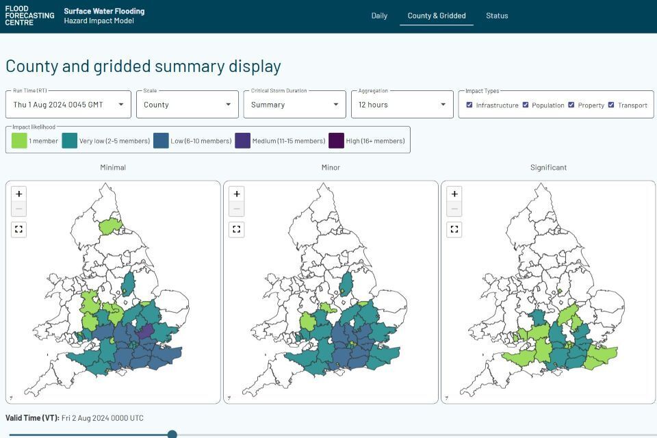
Image credit: Met Office
Why responders need better nowcasting
Our user research shows that responders want more local detail, especially in the 2 to 6 hours before a rapid flood event. This is a critical period when they need to move equipment, warn communities and prepare emergency actions.
The current RFG service uses detailed short term forecasts of storms (convective nowcasting) from the Met Office’s Expert Weather Hub, supported by hydrometeorologists at the FFC.
However, it does not yet include real time hazard and impact modelling which could, in future, be provided by tools such as SWFHIM.
Surface water flood model nowcast trial
To fill this gap, the FFC trialled two new tools for surface water flood hazard and impact modelling in the nowcasting (0 to 6 hour) lead time:
- a nowcast version of SWFHIM
- the FOREWARNS surface water flood model from the University of Leeds
Both models used Met Office nowcast rainfall ensemble forecasts. These combine radar data with model output to give a rainfall forecast up to 6 hours ahead.
The objectives of the trial were to:
- evaluate the performance of the tools for operational forecasting
- assess how much value they add to current ways of forecasting rapid flood events
- gather user feedback on what a future operational surface water flood model nowcast tool should look like
Phase 1 took place in the 2024 Met Office summer testbed with more than 50 meteorologists, modellers and academics from the United Kingdom and overseas.
Phase 2 in 2025 focused on the FFC and Met Office teams who will use the tools in an operational environment.
What the trial found
The main finding of the trial was that SWFHIM and FOREWARNS are both useful for objective decision making during the RFG production process. It showed that:
- improvements could have been made to the RFG forecast on nearly 50% of occasions
- the surface water flood models can improve identification of impact thresholds for RFG issue
- location accuracy and lead times of issue were improved in some cases
Overall:
- SWFHIM performed best for showing likelihood and impact severity - and for identifying impact types
- FOREWARNS was valued for its simplicity and the context it added to events
Looking to the future
Overall, the trial has established the case for future investment in surface water flood modelling tools.
Based on the trial, the recommendations include:
- progressing with a series of performance improvements for SWFHIM and FOREWARNS with science partners – including the next generation of rainfall nowcast data from the Met Office (available from 2027)
- prioritising SWFHIM nowcast tool development in line with user requirements - to provide new capability for impact based and probabilistic output in the 0 to 6 hour lead time
- considering implementing FOREWARNS as an operational prototype - to further assess usefulness of extra contextual information for forecasters
- implementing automated approaches for verification of surface water hazard/impact models – so we can measure the forecast improvements
We are currently planning that these recommendations will be incorporated into a 3-year project which will bring new tools into operations by 2029.
This will improve the accuracy and timeliness of the RFG service – allowing better decision making when planning flood response.