Satellite Oceanographic Consultants (Africa) Coastal monitoring
Coastal Risk Information Service for Madagascar, Mozambique, South Africa

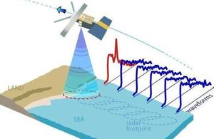
Diagrammatic representation of satellite altimeter measurements of the coastal zone
Project title
C-RISe Coastal Risk Information Service
Target Countries
Madagascar, Mozambique, South Africa
Project Lead
Satellite Oceanographic Consultants Ltd (SatOC)
Project Consortium
SatOC, National Oceanography Centre, Bilko Development Ltd
International Partners
Madagascar: Centre National de Recherches Océanographiques (CNRO), Institut Halieutique et des Sciences Marines (IH.SM), Direction Générale de la Météorologie (DGM), WWF Madagascar, Conservation International Mozambique: Instituto Nacional de Hidrografia e Navegação (INAHINA), Universidade Eduardo Mondlane South Africa: Council for Scientific and Industrial Research (CSIR)
Project Summary
C-RISe will be carried out by an international partnership between the UK, Mozambique, Madagascar and South Africa, to provide satellite-based information on sea level rise, storm surges, extreme wind speeds and wave heights. The goal is to enable local stakeholders to use this information in reducing the social and economic impact of coastal hazards and increasingly variable weather patterns. C-RISe will enable stakeholders to obtain information about coastal vulnerability that is not currently available; this increased capacity will enable them to evaluate future risks.
The C-RISe team will apply an innovative satellite altimeter data processing technique, developed in the UK, to provide detailed measurements of sea height in the Mozambique, Madagascar and South Africa coastal regions. These satellite observations will be analysed by a range of case study applications and accessed through a web-based data portal. Through the use of the C-RISe satellite system and a training and development software system (BILKO), local users will be trained in the validation and use of satellite oceanography data to enable coastal hazards to be quantified and incorporated into a number of ongoing development and disaster prevention initiatives.
C-RISe will be carried out over a three-year period, consisting of a first phase of defining the user requirements, a second phase of data application and training and a third phase of service evaluation. The project will be carried out by a core team of scientists from research institutes in each respective country, working with government departments and NGO’s.
Objectives
- Deliver a Coastal Risk Information service (C-Rise), providing satellite-derived information about coastal vulnerability to environmental threats such as sea level rise and extreme wind and wave events.
- Apply and evaluate the C-RISe service, using it to create applications that can meet local priorities.
- Train local users to use satellite data so they can provide scientific support for strategy development, governance and management of coastal areas to help increase their resilience.