Map of Scientific Advisory Committees / Councils and Arm’s Length Bodies associated with government departments
Updated 19 March 2024

© Crown copyright 2024
This publication is licensed under the terms of the Open Government Licence v3.0 except where otherwise stated. To view this licence, visit nationalarchives.gov.uk/doc/open-government-licence/version/3 or write to the Information Policy Team, The National Archives, Kew, London TW9 4DU, or email: psi@nationalarchives.gov.uk.
Where we have identified any third party copyright information you will need to obtain permission from the copyright holders concerned.
This publication is available at https://www.gov.uk/government/publications/scientific-advisory-committees-code-of-practice/map-of-scientific-advisory-committees-councils-and-arms-length-bodies-associated-with-government-departments
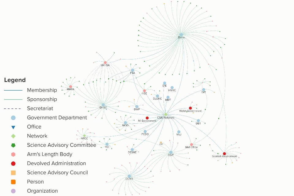
A systems map of the Science Advice Committees / Councils and Arm’s Length Bodies associated with government departments. Credit: Government Office for Science/Kumu.
1. How to interact with the map
Please click this link to access the map. This link will take you to an external page where you can interact with the map.
2. The purpose of the map
This map aims to represent the Science Advisory Councils and Committees (SACs), and Arm’s-Length Bodies (ALB) which provide science and evidence advice to government. The information is correct at 12 February 2024.
There are a multitude of uses for the map, both for inside and outside of government:
- For transparency purposes, to clearly display connections between departments and science advisory bodies.
- For training purposes, to allow people inside and outside of government to study and understand the science system in government.
- For policy purposes, to allow those working on specific topics to find where relevant science advisory bodies are and expand their range of expertise.
- For engagement purposes, to signpost where opportunities might exist for external experts to engage with policy.
All the information on this map was initially gathered from www.gov.uk and then reviewed by stakeholders across government.
The map includes the full name of the body represented, the webpage, contact details (if publicly available), the type of organisation and connections to other bodies on the map.
3. Boundaries and criteria for inclusion
The map only includes bodies that are:
-
published on gov.uk (or for devolved administrations gov.scot, gov.wales and northernireland.gov.uk) and
-
provide science and evidence advice in government
The map does not aim to show all expert and policy advice in government but is a faithful representation of the way departments see their ecosystem of SACs and ALBs on the date of publication.
The map’s boundaries are set to only include bodies which are directly linked to departments via sponsorship. Most bodies which were linked to an ALB rather than a department were removed from the map to reduce the complexity.
The map does not display all existing relationships between different nodes. We set a high threshold displaying only sponsorships as a connection type to limit complexity and improve readability. Where relevant and informative, we have displayed if a body provides secretariat to another, however the secretariat function is not limited to those displayed on the map.
4. Nodes descriptors
-
Science Advisory Committees (SAC) are groups of experts who meet regularly to advise on a particular topic or issue.
-
Science Advisory Councils (SAC) offer strategic direction and review across the whole of their sponsoring organisation’s science remit.
-
Government departments are a sector of the UK government that deals with a particular area of interest (those included are represented on the Chief Scientific Advisers network).
-
Arm’s-Length Body (ALB) are a specific category of central government public bodies that are administratively classified by the Cabinet Office. Only ALBs with a scientific remit are represented.
-
Chief Scientific Advisers Network (CSA Network) consists of the GCSA and the departmental Chief Scientific Advisers (CSAs). The purpose is to champion the Government Science and Engineering (GSE) profession, unite the scientific aims of each department and bring scientific evidence to the centre of decision-making in government. It is one of the many already existing networks between the represented bodies. The same departments are also represented in a Deputy Chief Scientific Advisers network and the CSA Officials network.
-
Devolved Administration are the representation of the other nations within the United Kingdom, i.e. Northern Ireland, Scotland, Wales.
-
Offices are usually headed by senior civil servants who can often advise or fulfil an inspection or regulatory function. However, to date, there is not a central definition in government possibly due to the disparate functions offices fulfil.
5. Connections descriptors
-
Sponsorship is the activity that delivers effective relationships between departments and their ALBs, in turn facilitating accountable, efficient and effective services to the public[footnote 1].
-
Secretariat means an organisation is providing impartial support to the SAC by drafting, reviewing, maintaining and updating documents required by the SAC and is responsible for ensuring that the proceedings of the SAC are well documented so there is a clear audit trail showing how the SAC reached its decisions[footnote 2].
-
Membership means that a given entity is a member of a network.
NB. Some bodies can be sponsored by one department / ALB and have a secretariat function elsewhere. Bodies can also provide both sponsorship and secretariat to another body.
6. Tags assignment
The tags have been added to the map to highlight the type of research that a body does. The tags were provided by representatives of the body or in the case no such information was provided, they have been tagged by a member of the team who has identified the tags based on the key research themes listed on the body’s website. The tags have been aligned with the taxonomy of the Areas of Research Interest (ARI) Database. If in the case there was no suitable taxonomy, an appropriate tag has been given.
The departments themselves have not been tagged as they are not SACs or ALBs. This means when a particular tag is selected such as ‘Food’, the Department for Environment, Food and Rural Affairs (DEFRA) will disappear from the map. This does not mean there is no expertise or interest in the departments themselves, this map solely focuses on SACs.
7. Map maintenance
The map was created by the Science Systems and Academic Engagement (SSAE) team within the Government Office for Science. Departments can get in touch with the team to make any changes at any time. Periodically, the Government Office for Science team will check with the Secretaries of the Science Advisory Councils and Committees and the CSA offices to ask if any changes have been made to the relevant bodies.
8. Annex A: how to use the map
A quick how-to guide to make the use of the map easier for stakeholders.
8.1 How to zoom in and out
You can zoom into a particular section of the map by using the zoom in and out button on the top right-hand side of the map or by scrolling in and out using the mouse. You can move the area of the map you are looking at by clicking and moving the map with your mouse.
8.2 How to view a department or SAC
If you want to view a particular department or SAC, you click the dot of the item you want to view, this will bring up the information on the left-hand side. If you want to close this, click anywhere on the map which is blank.
If you have a particular department, SAC or Arm’s-Length Body you want to find, you can use the search bar located at the top left-hand side of the map.
8.3 Focus mode
If you would like to focus on just one department you can use focus mode. This hides anything that does not have an immediate link to the department you select.
The focus mode option can be found on the icons on the right-hand side:
To exit focus mode, select the clear focus icon (same location as focus mode).
8.4 How to filter by tag
- Click on the ‘tags’ drop-down menu located centrally at the bottom of the map.
- Select the tag(s) you want to see. You can view multiple at a time.
- If you want to see the departments as well as the SACs/ ALBs related to the selected tag, select the departments tag at the top of the list.
- To unselect, click on the tag or click ‘select all/ view all’ at the top. This will display the map with no filters.
-
Code of Practice for Scientific Advisory Committees and Councils: CoPSAC December 2021* * * ↩
-
Code of Practice for Scientific Advisory Committees and Councils: CoPSAC December 2021 ↩