Soil moisture and ocean salinity (SMOS)
The mission makes global observations of the Earth's surface soil water content and the salt in the oceans.

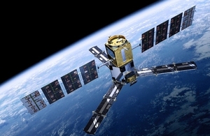
Artist's impression of SMOS in orbit. Credit: ESA.
A greater understanding of soil moisture and ocean salinity will lead to better forecasting of weather and extreme-weather events.
Studying the Earth’s salt and water
Soil moisture and humidity are connected. If soil becomes dry, due to drought, then less water evaporates into our atmosphere. More moisture raises humidity and also lowers temperatures.
The salinity of the sea affects ocean currents. The salt content varies due to the addition or removal of fresh water through evaporation and rain and from melting ice in polar regions.
SMOS is the second Earth Explorer Opportunity mission and is part of ESA’s (European Space Agency) Living Planet Programme. Its data will contribute to seasonal climate forecasting and will also help studies of regions of snow and ice.
For more detailed information, visit the ESA website.
Mission facts
SMOS was launched on 2 November 2009.
Its main instrument MIRAS (Microwave Imaging Radiometer using Aperture Synthesis) can measure as little as 4% soil moisture from space.
The satellite makes observations over a hexagonal area of almost 1,000km across and achieves global coverage every 3 days.
SMOS completed its nominal lifetime in November 2012. However, due to the extensive use, excellent technical and scientific status along with first-rate data products, the mission was extended until 2019 and again until the end of 2025.
For further information on the SMOS mission, please find below a link to the interactive SMOS multimedia book.
Technology
MIRAS is a new type of instrument that can observe both soil moisture and ocean salinity by imaging emitted microwave radiation at a frequency of around 1.4GHz.
The Y-shaped antenna on MIRAS has 69 small receivers, 23 on each arm.
A 2-dimensional measurement image is taken every 1.2 seconds.
How is the UK involved?
SciSys UK Ltd was responsible for the design and implementation of the satellite’s main instrument control and data handling software. They are also responsible for the MIRAS simulator that was used to support instrument commissioning.
Two Principal Investigators involved in SMOS are from the National Oceanographic Centre, Southampton and De Monfort University’s Earth and Planetary Remote Sensing Laboratory, Leicester.
ComDev developed the X-band filter while Chelton Antennas was involved in the manufacture of the antennas.
Updates to this page
-
Slight changes to content throughout to account for updates to the mission.
-
Page content updated.
-
Page content updated.
-
First published.