CryoSat
Measuring the shape and thickness of Arctic and Antarctic ice, the mission tells scientists how melting Polar ice affects sea level rise.

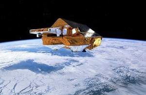
Artist's impression of CryoSat. Credit: ESA.
Importance of the Polar regions
Earth’s cryosphere is a key indicator and driver of global climate change; retreat of the Arctic sea ice cap and ice losses from Antarctica and Greenland are issues of critical societal importance. CryoSat is uniquely able to survey these changes, as there is no equivalent mission in any Earth Science programme around the world. Ice plays a major role in the Earth’s climate system. The loss of polar ice affects sea levels, ocean currents and how much heat is absorbed from the Sun. To understand the impact of global warming it is vital to work out how much ice there is on our planet and monitor any changes. CryoSat-2 makes measurements of the ice sheets of Antarctica and Greenland as well as monitoring variations in Arctic and Antarctic sea ice.
CryoSat has acquired measurements of sea-ice and ice-sheet thickness changes with unprecedented accuracy. These regions have not been surveyed by any other altimeter mission, and so CryoSat’s measurements complement the long-term altimeter record to sub-polar latitudes, which began in 1991 with ERS-1.
Uniqueness of the CryoSat mission
CryoSat is currently the only mission capable of systematically charting the ice sheet’s contribution to global sea-level rises and the only one able to provide hemisphere-wide measurement of the thickness of Arctic sea ice, particularly over areas where the most dynamic changes are occurring. Across the Arctic ocean, CryoSat monitors around 95% of total sea ice, compared with other altimeters (e.g. Sentinel-3) which observe less than 70% of total ice and only 40% of multi-year sea ice. These latter values are expected to drop further in coming years because of changes in the polar seas where sea ice will mainly survive at very high latitudes. Over ice sheet margins, CryoSat is able to measure more than 95% of areas where the ice mass is changing - five times more than other existing and planned altimeters - representing a major improvement in our capacity to detect elevation changes in these key areas of dynamic imbalance.
CryoSat is currently the only mission able to monitor the polar oceans at very high latitudes. Furthermore, it is uniquely positioned to study and characterise, for example, variations in the polar ocean’s dynamic topography under sea ice, multi-scale ocean features at different scales and ice-shelf interaction with ocean dynamics including tides and coastal polar currents.
Technology
CryoSat-2 is equipped with highly accurate radar which has been specially designed for measuring the thickness of ice. It uses a twin radar system with two onboard radar receivers. This allows a 3-D view of the ice to be built-up. The spacecraft sends short radar pulses to the Earth and calculates the time it takes between the signal leaving and returning to the spacecraft. By knowing the exact position of the satellite, the height and thickness of the ice can be determined to the nearest centimeter.
CryoSat-2 also has an unusual appearance: it looks a bit like a house and has virtually no moving parts. This is because, unlike most missions, it has been specially designed to fly in an orbit that takes it right across the poles. As it orbits, its position relative to the Sun will change. In a traditional satellite design this would have meant the spacecraft having to keep adjusting its solar panels so they were always pointing at the Sun, otherwise it would run out of power. To overcome this problem, CryoSat-2’s panels are set at an angle to make sure they are always getting enough sunlight.
The importance of CryoSat
It is important that the CryoSat mission continues to operate in order to determine decadal trends in ice sheets, ice caps, glaciers and sea-ice mass, to separate seasonal and inter-annual variability from long-term trends. Namely, measuring ice-sheet contribution to future sea-level rise and mapping Arctic sea-ice thickness from space at very high latitudes has a major impact on long-term climate records.
UK involvement
Since 1998 when the CryoSat-2 mission was first proposed by Professor Duncan Wingham, currently the Chief Executive Officer of Natural Environmental Research Council (NERC), the UK has played a leading role in engineering hardware for the satellite, and scientifically exploiting the data. Industrial partners include: Marotta UK Limited which supplies high-performance fluid control components for space applications, AEA provided Cryosat-2’s battery, SciSys UK Ltd developed the onboard application software responsible for controlling CryoSat’s orbit and attitude as well as handling all of its communications with the ground segment. This collaboration between scientific and industry experts strengthens the UK’s position as a world leading space faring nation. Since its inception 20 years ago, CryoSat-2 has fundamentally advanced our knowledge of how the Polar regions are changing, and delivered a step change in the sophistication of radar altimeter satellites launched by Europe.
For more detailed information on CryoSat, visit the ESA website.
Updates to this page
-
Information on Cryosat significantly updated.
-
First published.