Post-incident reporting for reservoirs: annual report 2019
Updated 31 August 2023
Applies to England

© Crown copyright 2023
This publication is licensed under the terms of the Open Government Licence v3.0 except where otherwise stated. To view this licence, visit nationalarchives.gov.uk/doc/open-government-licence/version/3 or write to the Information Policy Team, The National Archives, Kew, London TW9 4DU, or email: psi@nationalarchives.gov.uk.
Where we have identified any third party copyright information you will need to obtain permission from the copyright holders concerned.
This publication is available at https://www.gov.uk/government/publications/reservoir-safety-post-incident-annual-reports/post-incident-reporting-for-reservoirs-annual-report-2019
Foreword
Reservoirs in England have an excellent safety record. The last reservoir failure that led to loss of life in England was more than 100 years ago. However, climate change, recent flooding and the events at the Toddbrook Reservoir show:
- we cannot be complacent
- how crucial it is for all infrastructure to be fit for the future
There are 2,092 large raised reservoirs (statutory reservoirs) in England covered by the Reservoirs Act 1975 (the act). Large raised reservoirs hold at least 25,000 cubic metres of water above ground level. This means they have to operate to strict conditions set by the act to ensure high levels of safety.
Reservoir operators and owners (undertakers) are responsible for ensuring the safety of reservoirs. The Environment Agency, as the regulator, ensures undertakers follow the legal safety requirements. The Environment Agency monitors compliance at all the large raised reservoirs in England. This includes collecting and recording information from reservoir undertakers on incidents. We use this information to improve safety by:
- investigating incidents where appropriate
- informing the reservoir industry of any trends and important lessons identified
- contributing to research into reservoir safety and incident analysis
Publishing this report means that everyone involved in reservoir safety has the opportunity to learn from past incidents. By sharing experiences we can improve safety for the future. So, please continue to help by reporting all incidents no matter how small or insignificant they may appear. This report covers incidents reported at reservoirs in England only.
I would like to thank everyone who has contributed to this report and supports the post incident reporting system. By doing this we are making a very real and tangible contribution to improving reservoir safety.
Antony Deakin, Reservoir Safety Manager, Environment Agency
Executive summary
For this report the Environment Agency received final information on 5 incidents that occurred during 2019. The most significant incident (Incident 454) occurred at Toddbrook Reservoir in August 2019. Two separate incident investigations were undertaken. The reports contain a detailed assessment of the Toddbrook incident and lessons learnt. They are the:
The Environment Agency also produced a Lessons Learnt Technical Bulletin.
We have not repeated the learning from these reports and bulletin in this report. But it is vital that everyone in the reservoir sector implements the learning in the interests of public safety.
Incidents are classified by their level of severity. They are:
- 1 (failure)
- 2 (emergency works)
- 3 (precautionary or unplanned works)
For more details on the classification system see the Incident classification levels section.
Five incidents occurred in 2019. One was a level 2 incident (Toddbrook). The Environment Agency formally investigated this incident. The other 4 were classed as level 3 incidents.
The Environment Agency also received final information on 5 incidents from 2018. One was classed as a level 2 incident and the other 4 were classed as level 3 incidents.
It is not unusual for reports to include information from previous years. This is because reservoir undertakers have 12 months to provide a full and comprehensive post incident report. They also provide a preliminary report as soon as the incident is under control.
A qualified reservoir engineer investigates all incidents. The incidents in this report are either resolved or have plans in place to address any outstanding issues.
Each case study in the report contains important learning points for each incident. The main overall learning points are the importance of:
- checking existing plans and records in order to remain familiar with the workings of the reservoir
- routine surveillance to detect potential issues
- increasing monitoring during periods of high water levels
Reporting incidents in England
Since July 2013 undertakers of large raised reservoirs in England must report any incidents to the Environment Agency. This is a requirement of the act and Regulation 14 of Statutory Instrument 2013 No. 1677.
Undertakers of small raised reservoirs are not required to report incidents to the Environment Agency, but they may report them voluntarily.
As soon as an incident is under control, the reservoir undertaker must provide a preliminary report to us. This report must contain:
- the date and time of the incident
- the location of the reservoir
- incident details (observations)
The reservoir undertaker must send the Environment Agency a final post-incident report form within a year of the incident. The report must contain:
- information about the facts relating to it
- analysis of its circumstances
- any conclusions
- any lessons learned from the incident
The Environment Agency reviews the final report and seeks further clarification if necessary. These annual reports summarise the main learning points. They may also include information about incidents from previous years. This is because undertakers have up to one year to submit their final post incident report.
This reporting process is separate to any incident response.
If you have concerns about the operation of a reservoir you should report it immediately to the:
- emergency services
- Environment Agency on the incident hotline 0800 80 70 60
Incident classification levels
The Environment Agency classify incidents according to the level of severity. There are 3 levels.
Level 1
This is a failure which is an uncontrolled sudden large release of retained water.
Level 2
This is a serious incident involving any of the following:
- an emergency drawdown
- emergency works
- a serious operational failure in an emergency
Level 3
Any incident involving:
- a precautionary drawdown
- unplanned physical works
- human error leading to a major (adverse) change in operating procedures
All these incident categories are covered by the regulations.
Reported incidents overview
This year the Environment Agency received final information for:
- 5 incidents that occurred in 2019
- 5 incidents that occurred in 2018
All these incidents were at statutory reservoirs with embankment dams. An embankment dam is a large artificial dam. It is typically created by the placement and compaction of various compositions of soil, sand, clay or rock.
The Environment Agency seeks advice from an independent reservoir engineer to classify the incidents. Following this advice we classified all incident reports in 2019 as level 3, except Toddbrook (Incident 454), which is a level 2.
The incidents in this report are either resolved, or have plans in place to address outstanding issues. The Environment Agency continues to review the 2018 level 2 incident number 448 (instability of embankment).
The Environment Agency report incident statistics every 5 years. The next report for 2020 will include updated statistics.
2019 incidents
Incident 454
Dam type: earthfill embankment.
Reservoir legal status: statutory.
Dam height: 23.8 metres.
Incident type: partial spillway collapse.
Incident severity: level 2.
A significant level 2 incident occurred at Toddbrook Reservoir in August 2019. There was a partial collapse of the emergency spillway. There was a multi-agency response to the incident and a major civilian evacuation. The reservoir was almost emptied and the dam temporarily repaired to enable residents to return home. There are 3 main reports with full information about the incident, its causes and lessons learned. They are the:
- Independent Government Review Report
- Canal and Rivers Trust Report
- Environment Agency Lessons Learnt Technical Bulletin
Incident 455
Dam type: earthfill embankment.
Reservoir legal status: statutory.
Dam height: 3 metres.
Incident type: flood overtopping.
Incident severity: level 3.
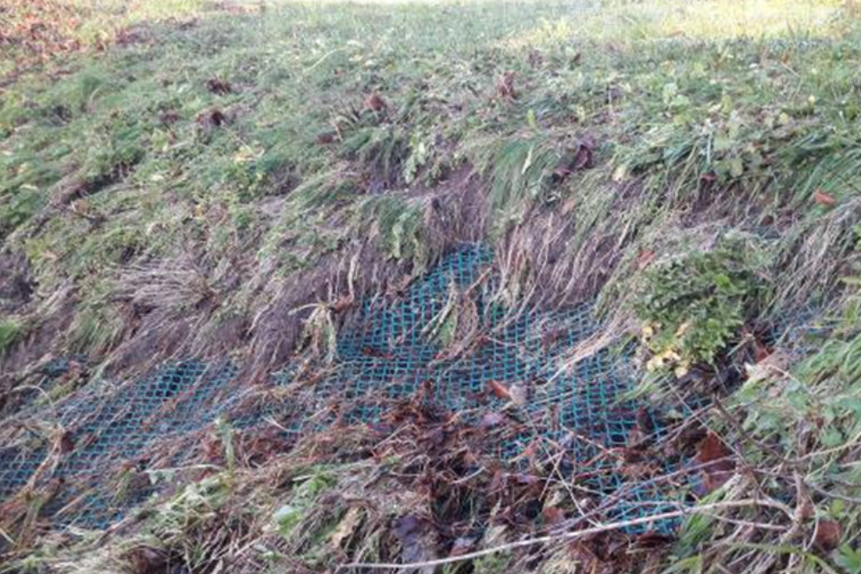
Description
A flood storage reservoir filled with water during severe rainfall. It caused the emergency overflow spillway to operate. Overtopping also occurred at a low spot on the main embankment crest. This caused some local scour damage (soil erosion).
Once the flood had passed and the water level had reduced, the supervising and previous inspecting engineers agreed the repair works. The main embankment crest was re-profiled and an enhanced system of scour protection installed.
The photograph shows the overflow of the main embankment at a low spot.
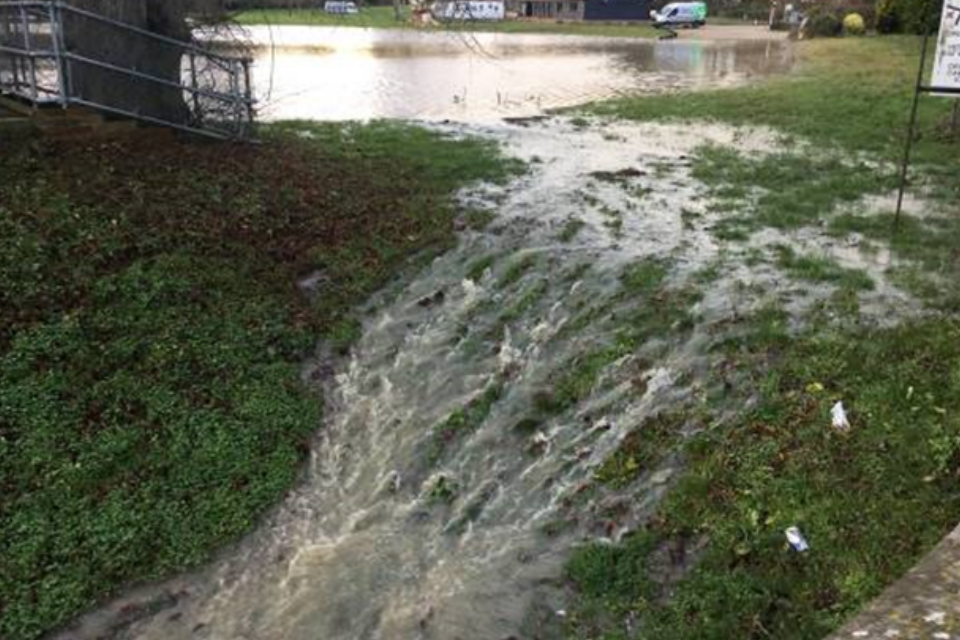
The photograph shows the erosion of the embankment surface.
Lessons learned
The reservoir was designed to overtop the main embankment during floods that exceed the 25-year flood level. The 25-year flood occurs on average once every 25 years or has a 4 percent risk of occurring in any given year. It should have overtopped along the length of the main embankment at a shallow depth, but it spilled over a low spot. The concentrated flow and erosion in this area caused serious localised damage to the embankment.
The low spot had not been evident during statutory inspections. The area was between crest settlement stations which are 30 metres apart. Low spots may not be evident through visual inspection or from routine surveys of widely-spaced crest pins.
Undertakers should carry out periodic topographic surveys of the entire dam crest. This will help to identify low spots where changes in crest elevation may be critical to dam safety.
Incident 453
Dam type: earthfill embankment.
Reservoir legal status: statutory.
Dam height: 8 metres.
Incident type: leakage - unknown pipe outlet.
Incident severity: level 3.
Description
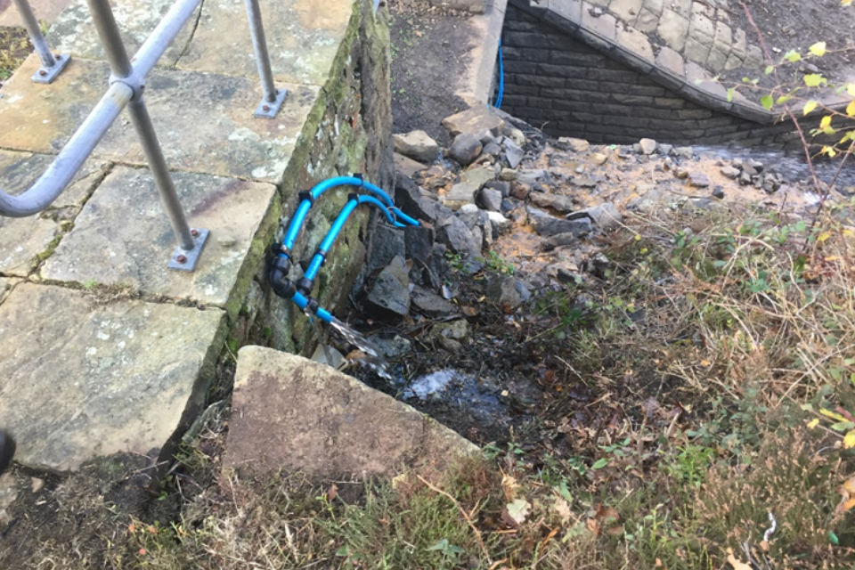
This incident occurred at a non-impounding reservoir served by a rising (upward flowing) main water pipe. A large pool of water was found near the downstream toe of the earth embankment. Water was flowing through sub-surface service ducts. The water was at the same location as the 1.22 metre diameter rising main serving the reservoir and a nearby watercourse.
The undertaker isolated the main and reduced the standing water. They lifted and inspected all the drainage manhole covers in the area. One manhole lay directly on the line of the pumping main and was not identified on the reservoir records. A pumping main is a main water pipe through which water is pumped. Within the manhole there was a small gate valve and a damaged flexible hose. They opened the reservoir outlet valves which confirmed this gate valve was not completely closed. The pipeline was again isolated and the gate valve replaced. The undertaker then added the location and nature of the manhole to the reservoir records.
Lessons learned
The incident occurred due to pressure on a partially open valve located close to a dam embankment. This led to surface water ponding and concerns for the safety of the embankment. Undertakers should ensure that reservoir records include details of all the pipework and valves associated with operating it.
Incident 452
Dam type: earthfill embankment.
Reservoir legal status: statutory.
Dam height: 34 metres.
Incident type: internal erosion.
Incident severity: level 3.
Description
Routine surveillance identified cloudy water emerging at the downstream toe of an embankment dam. This was along the line of a channel that was damaged and relined after the reservoir was first filled over 160 years ago. A clay blanket had previously been applied to the upstream face to reduce the risk of such leaks. The leakage occurred in an area on the crest where the undertaker was investigating an increased rate of settlement.
The reservoir is part of a cascade of reservoirs. The undertaker lowered the water level in the subject reservoir, and in the reservoirs upstream and downstream. They used geophysics to identify the elevation of the seepage path through the core. It appeared that some degradation of the clay blanket may have occurred. This led to internal erosion on the line of the original conduit or on a path through the core close to the conduit. Ongoing monitoring of the leak continues and will be used to inform a programme of works.
Lessons learned
The incident highlights the value of undertakers carrying out routine surveillance and crest level monitoring to identify the onset of internal erosion. An increase in settlement rate was noted before the incident was reported. The frequency of surveillance should be increased in response to increased crest settlement.
Both active and abandoned conduits can pose a specific risk of internal erosion in earthfill embankments. This can be long after they were first constructed. It is important that undertakers keep and maintain full records of their assets over time.
Incident 451
Dam type: earthfill embankment.
Reservoir legal status: statutory.
Dam height: 21 metres.
Incident type: control valve failure.
Incident severity: level 3.
Description
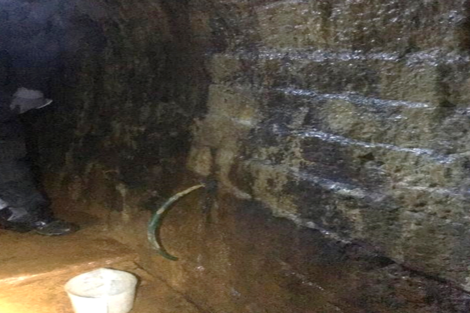
This incident occurred at a remote moorland impounding reservoir. The draw-off pipework had been previously modified to provide upstream control of water pressure via a valve. There had been concerns that leakage from the original draw-off pipe (through the core of the reservoir) had caused internal erosion. Sandy water emerging through the wall of the draw-off tunnel was evidence of internal erosion. This occurred a short distance downstream of the core.
In the late 1990s, the undertaker:
- carried out grouting works
- fitted a hydraulically-operated knife valve to a pipe extension at the upstream end of the draw-off pipe
The valve was replaced in 2009. In August 2018, the undertaker lost control of the submerged knife valve. It was thought that the valve was in the fully open position. This meant it was subjecting the draw-off pipe to the full pressure of the water in the reservoir. They decided to keep the water level in the reservoir low and measure the water flowing into the draw-off tunnel on a weekly basis.
The undertaker considered using divers to repair the valve. This was discounted, as it would be too difficult to empty the reservoir water in the hydraulic pipes used to operate the valves.
In early 2019, analysis of the draw-off flow against the reservoir head indicated that the valve was in a partially-closed position. The reservoir head is the pressure exerted by the water in the reservoir. This meant it would be difficult to keep the water level low until they could access the valve to repair it. The undertaker planned to set up equipment on site to lower the water level. This was not possible as they needed to build an access track which would cause environmental damage to moorland.
The reservoir level was reduced during a dry period the following month. This allowed direct access to the valve. The piston in the valve’s hydraulic ram was faulty and it was repaired. Further grouting works are planned to seal voids within the core of the embankment and behind the walls of the draw-off tunnel.
The photograph shows the hydraulically-operated knife valve.
The photograph shows the seepage monitoring point in the draw-off tunnel.
Lessons learned
This incident highlights the difficulties that can arise from using hydraulically activated upstream control valves on draw-off tunnels. The valve was fitted to the only low-level outlet through the dam. The dam had already suffered internal erosion. The only way to repair or replace the valve was to almost completely drain the reservoir.
The incident highlights the need for engineers to carefully consider the design of the valves to dam outlet pipes. The design should take into account the need to maintain, replace or retrofit them. It also highlights the difficulties of doing emergency works in remote locations and where environmental issues can affect access. In such locations, undertakers should store relevant materials and equipment on site and use them at a less environmentally sensitive time of year.
2018 incidents
Incident 450
Dam type: earthfill embankment.
Reservoir legal status: statutory.
Dam height: 22 metres.
Incident type: erosion on reservoir rim.
Incident severity: level 3.
Description
Water overflow from a nearby service reservoir eroded the surface next to an earth filled dam. When it happened, the water level in the impounding reservoir was low. This made the erosion worse. The undertaker thought the erosion may have affected a clay blanket on the upstream face of the dam. A clay blanket is typically used to prevent seepage from the foundation. The owner increased surveillance at the dam and the engineer investigated the eroded area. This confirmed that there was no clay blanket in the eroded area. The affected area was filled with coarse granular fill material.
Lessons learned
Concentrated flows of water from stream or pipe inlets to a reservoir could cause erosion next to an earthfill dam when its water level is low. The undertaker or engineer should assess the dam’s safety risks and put appropriate control measures in place.
Incident 449
Dam type: earthfill embankment.
Reservoir legal status: statutory.
Dam height: 2.5 metres.
Incident type: instability of embankment.
Incident severity: level 3.
Description
A berm (raised bank) on the upstream side of a washlands embankment became unstable. The supervising engineer noted:
- instability affecting the slope above a drainage ditch
- some tension cracks at the top of the berm
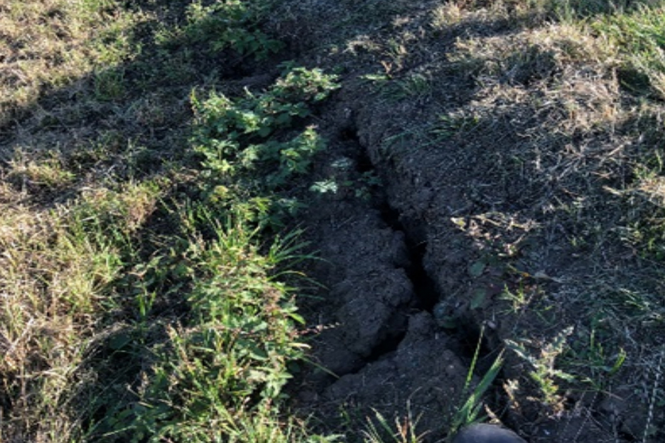
There were 2 separate but adjoining unstable areas. The instability may have occurred sometime before, but it was not identified until the vegetation was cleared. A qualified civil engineer supervised appropriate repairs to a 50 metre section of the embankment.
The photograph shows tension cracks at the top of the berm.
Lessons learned
The embankment has a clayfill (a clay centre). The repair work highlighted the clay has a stepped profile which resulted in local sections of deep topsoil. The 2 failure planes were shallow and within the topsoil. This shows the importance of good routine maintenance and regular inspections to look for changes. In this case the maintenance programme was adjusted to ensure the vegetation is cleared and the grass is cut regularly on all parts of the embankment.
Incident 448
Dam type: earthfill embankment.
Reservoir legal status: statutory.
Dam height: 5.5 metres.
Incident type: instability of embankment.
Incident severity: level 2.
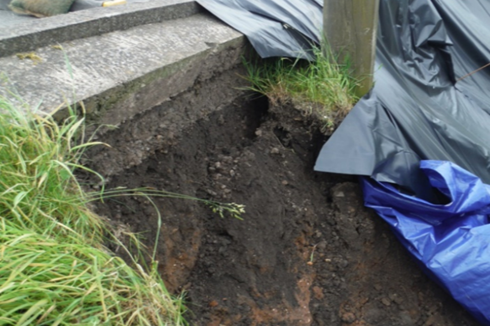
Description
The design of a non-impounding farm reservoir was changed during construction. The interior clay liner was omitted, and the interior face was constructed steeper than required.
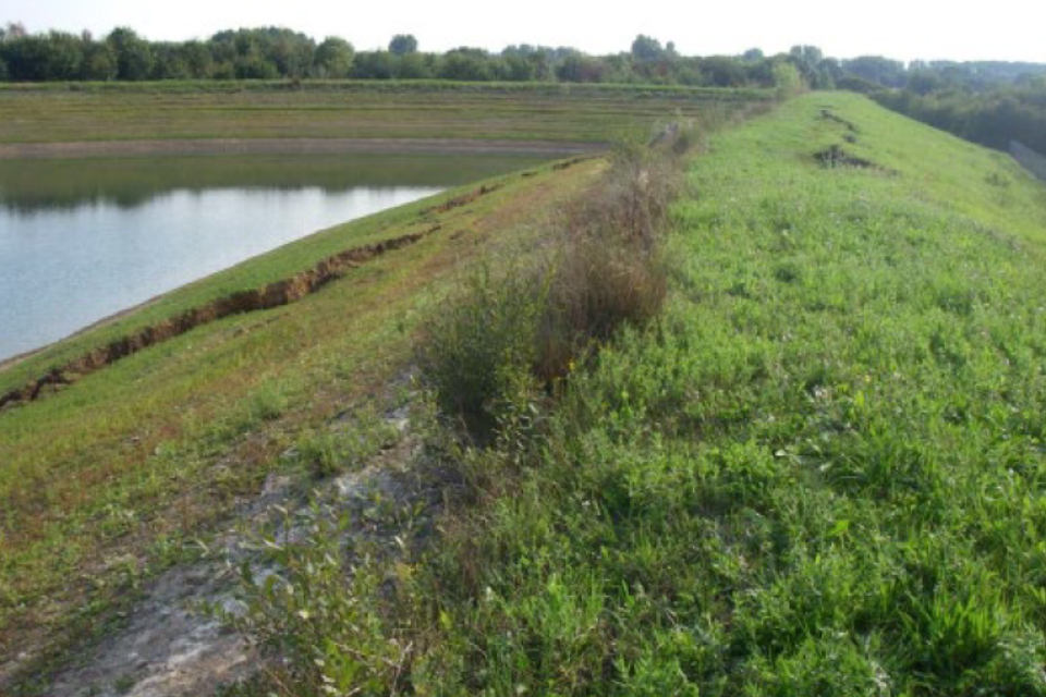
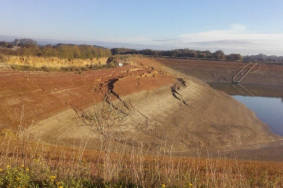
A few years after it was completed the water level in the reservoir was rapidly lowered. This caused the interior shoulder of the earth embankment to become unstable. The instability led to tension cracks and slip planes passing through the crest (top of the dam) and upstream shoulder material. The reservoir was then emptied by pumping water down to the level of the natural surrounding ground. Further instability occurred during this period. The undertaker subsequently decided to close the reservoir.
The photograph shows the instability of the crest and upstream (interior) shoulder following the initial lowering of the reservoir.
The photograph shows a view of further instability following the emptying of the reservoir.
Lessons learned
Undertakers must adhere to the design agreed with the construction engineer. The construction engineer must verify the construction is adequate before signing the final certificate.
The Environment Agency is still investigating this incident.
Incident 447
Dam type: earthfill embankment.
Reservoir legal status: statutory.
Dam height: 25 metres.
Incident type: leakage – deterioration of outlet works.
Incident severity: level 3.
Description
This incident occurred at an impounding reservoir located in a cascade of reservoirs. A cascade is a chain of reservoirs along a river, one below the other. The water level in the downstream reservoir submerges the draw-off tunnel when it is high. There are 2 historical seepage points in the draw-off tunnel. The supervising engineer assessed these when the water level in the downstream reservoir was low. They found the flow rates were greater than those shown in historical records. Piezometers in the embankment had not indicated any deterioration in the seepage performance of the embankment.
An inspecting engineer advised the undertaker to pipe the 2 seepage flows out of the tunnel to a point above the top water level of the downstream reservoir. This enabled regular monitoring of the flow rate, and increased surveillance frequency.
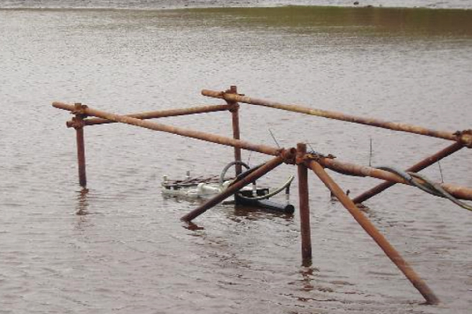
To find the likely leakage paths they monitored the leakage flows and piezometer readings against the reservoir water level for more than a year. The investigations found the leakage paths are likely to be between the cast iron segmented tunnel lining and the concrete backing. The undertaker plans to do grouting works to repair the tunnel.
The photograph shows the channelling of tunnel seepage for pipe connection and flow monitoring.
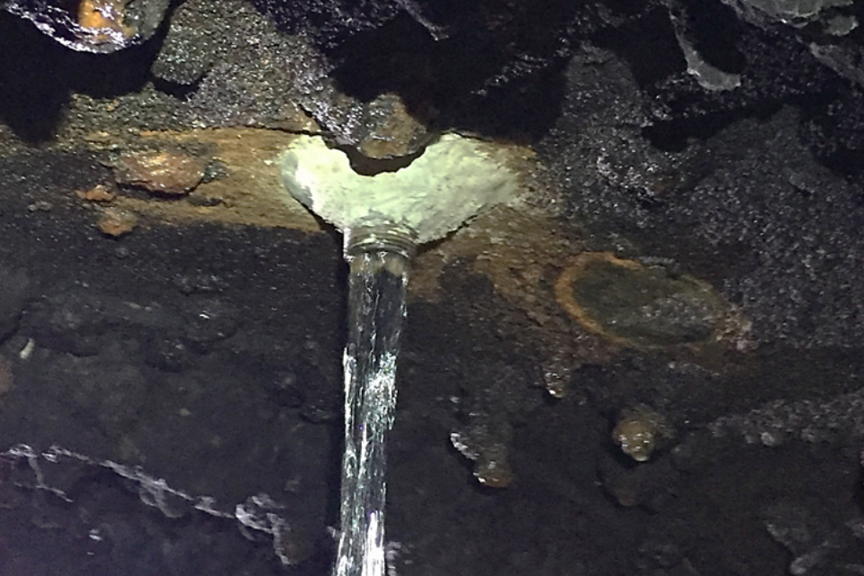
The photograph shows the seepage monitoring pipes outside the tunnel.
Lessons learned
This incident demonstrates the challenges of monitoring dams which are partially submerged on the downstream side. When a possible deterioration in the performance of the dam was identified, a novel means of monitoring the seepage flows was developed. This new way of monitoring did not impact the operation of the downstream reservoir. Undertakers and engineers should consider using it.
Incident 446
Dam type: earthfill embankment.
Reservoir legal status: statutory.
Dam height: 6 metres.
Incident type: instability of embankment.
Incident severity: level 3.
Description
The incident occurred at a 200-year old impounding reservoir. It has an earthfill embankment with a puddle clay core. An impounding reservoir is a reservoir constructed in the valley of a stream or river. Its purpose is to hold the flow of the stream or river to store water for future use.
A 1,000-year extreme storm event affected the catchment where the reservoir is located. Water levels in the reservoir increased but did not go over the top of the dam. However, 2 separate areas of instability to the embankment occurred. These were shallow slips (earth movements) on the grassy banks of the downstream face of the embankment. There was no indication that the slips had compromised the core.
The reservoir owner assessed the overall stability of the dam and found it to be satisfactory.
As a precaution the water level was lowered and kept at one metre below the top water level. The top water level is the level to which water may be stored. The slips were covered in tarpaulin to protect them from further rainfall.
A statutory inspection by an independent reservoir engineer recommended investigations to inform suitable remedial measures. Following the investigations, the areas of instability were filled with material to restore the embankment and the reservoir was re-filled. As an additional measure piezometers were installed to improve water pressure monitoring at the dam.
The photograph shows the 2 earth slips on the downstream face of the embankment.
The photograph shows the steep face (scarp face) caused by erosion of the failure plane on the downstream side of the dam crest.
Lessons learned
Extreme direct rainfall caused the failures of 2 grassy earth slips on the downstream face of the embankment. This also resulted in some additional steep face (scarp face) erosion on the downside of the dam crest. The investigation found that the downstream shoulder materials of the dam had unusual characteristics. They were very variable, with alternating layers of clay and sand/gravel.
Engineers need to be aware that very old dams may not be built using current best practices. They should consider reviewing the original design drawings and doing trial holes in the embankment to help identify any discrepancies in its construction.
Engineers used information about the slope failures to study the likely effects of rain on the stability of the embankment. The study indicated that heavy, prolonged rainfall could cause deeper slips which could affect the stability of the clay core.
A public road at the toe (base of the dam) has limited the options to improve the stability of the dam. Engineers recommended that a sub-surface drainage system be installed in the downstream shoulder of the dam. This will limit pore pressure rise (pressure of water inside the dam) under extreme rainfall conditions and help with embankment stability. There are also works planned to address some variability in the level of the top of the core.