How to read a title plan
Published 4 November 2021
Applies to England and Wales

© Crown copyright 2021
This publication is licensed under the terms of the Open Government Licence v3.0 except where otherwise stated. To view this licence, visit nationalarchives.gov.uk/doc/open-government-licence/version/3 or write to the Information Policy Team, The National Archives, Kew, London TW9 4DU, or email: psi@nationalarchives.gov.uk.
Where we have identified any third party copyright information you will need to obtain permission from the copyright holders concerned.
This publication is available at https://www.gov.uk/government/publications/how-to-read-a-title-register-and-title-plan/how-to-read-a-title-plan
When HM Land Registry registers a property, we give it a unique reference called a title number and, in most cases, prepare both a register and a title plan.
The register shows important information about the property, such as the names of the legal owners and whether there are any mortgages, rights of way or other legal matters that affect it.
The title plan supports the description of the property in the register; we use an extract from the Ordnance Survey (OS) map to give a visual indication of the registered land in red edging. We call this the extent.
Get a title plan
To get a title plan, you can:
- download a copy using our Search for property information service – copies cost £3
- order an official copy by filling in form OC1 – official copies cost £7
Whichever you choose, you can rely on the copy to show the state of the title plan at the date and time shown. If there are changes waiting to be made to the register, as these might affect the plan, your copy will be backdated to the time immediately before the first change was applied for.
What the plan shows
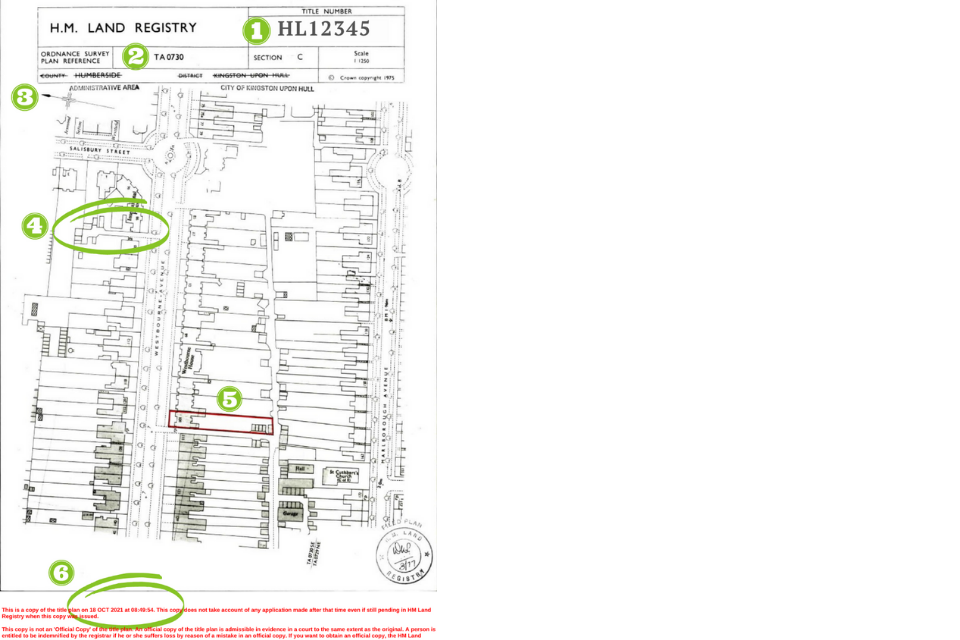
The property registered under title number HL12345 is an end-terrace house with land to the front and back, plus outbuildings which could be sheds or garages.
In this example you can see:
- The unique title number of the registered property.
- The map reference for the part of the Ordnance Survey map used to prepare the title plan.
- An arrow pointing North on the map.
- Black lines that represent physical features such as buildings, walls, fences or hedges.
- Red lines identifying the registered land (the extent).
- The date and time the copy was taken.
References on the title plan
The title plan sometimes shows other colours, letters and symbols. We call these references.
References are sometimes used on the title plan to identify areas affected by particular entries in the register, such as:
- easements (such as rights of way, either those for neighbouring owners over the property or those which benefit the property over neighbouring land)
- restrictive covenants (which are promises not to do something on part of the property)
- boundary agreements (which may refer to a position of a boundary between neighbouring owners or specify who owns or must maintain a boundary structure)
Look at your register to see what any reference on the title plan means. If your plan does not have a colour reference, it does not mean your property is not affected by easements, covenants or other agreements. Where we can clearly identify land affected without the need for a visual reference, we will describe that land in writing in the register.
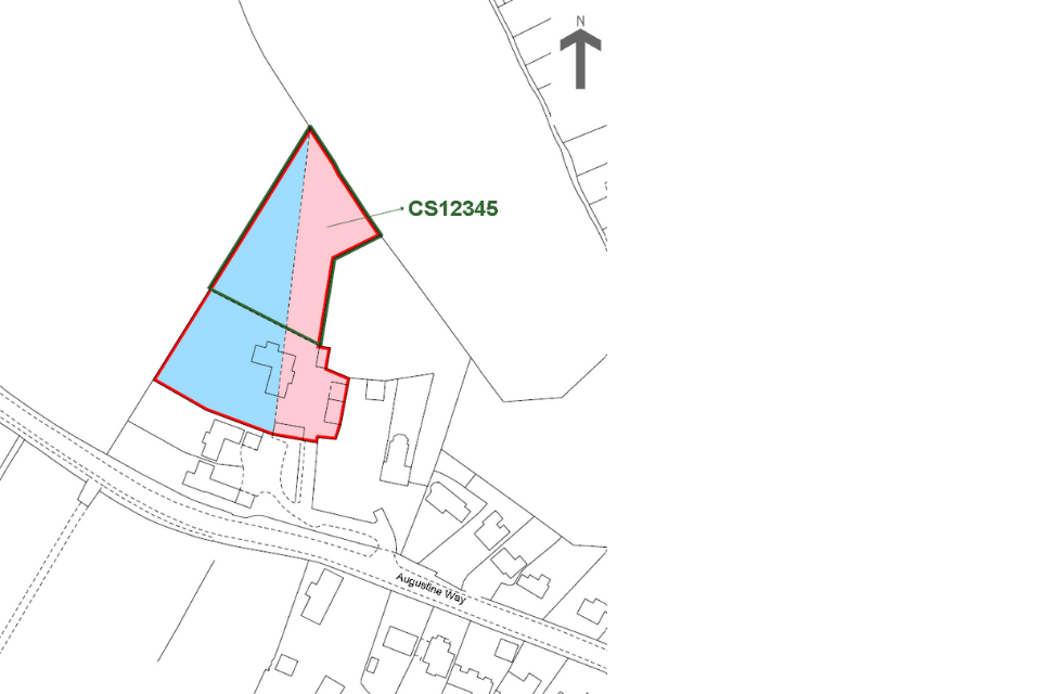
Read the title plan with the register
Where land has been removed from the title (such as when part of the garden has been sold off) this is usually shown by green edging. Sometimes the new title number for the area removed is also shown in green.
There are many reasons why colours or other references are added to a title plan and they will be explained in the register.
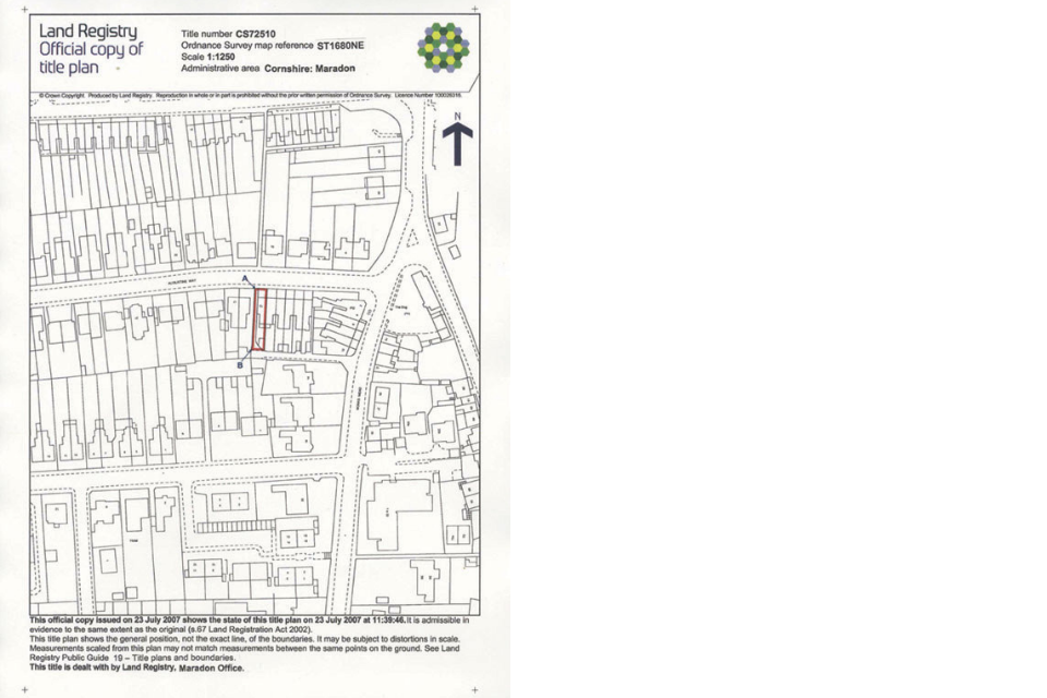
The following text is an extract from the ‘charges’ section of the register of a title register which accompanies the plan shown above.
C. Charges register
This register contains charges and other matters that affect the land
-
(20.12.2006) The land tinted blue on the title plan is subject to such restrictive covenants as may have been imposed thereon before 16 October 1960 and are still subsisting and capable of being enforced.
-
(20.12.2006) A conveyance of the land tinted pink on the title plan dated 20 June 1983 made between (1) Edward Grundy (Vendor) and (2) Alan Peters (purchaser) contains the following covenants:-
“The purchaser to the intent and so far as to bind the land hereby conveyed hereby covenants with the vendor for the benefit of the vendors adjoining estate that the purchaser will not use the land conveyed for any trade or business or suffer or permit to be done thereon any act which might be deemed a public nuisance or private inconvenience”
You should always read the title plan with the register. Find out how to download and read a title register.
Ordnance Survey map
Do not worry if the physical features shown on your plan look out of date. The earliest title plans still in use were first prepared over 100 years ago, and there may be other reasons why yours does not show a building or structure even though it may have existed for many years.
We use the most up-to-date edition of the OS map available when we prepare a title plan, but we do not update it each time the OS revises its map for the area.
Sometimes, we do prepare a new title plan. This may be when part of the registered property is sold or, occasionally, where the OS map used to create the title plan has become so out of date, we think the title plan may cause confusion.
Boundaries
Every property has legal boundaries which mark the limit of what a person owns, but it is not always easy to identity them exactly.
Find out more about legal boundaries.
Red edging on a title plan
The red edging on a title plan shows the extent of the registered land. It will often follow boundary features that are shown on the OS map, such as walls, hedges and fences. While a legal boundary often follows these features, too, even in these cases it might not be obvious exactly where the legal boundary is - for example, does it run through the middle of a hedge or to one side of it?
When we prepare a title plan, we try to show the legal boundaries as best we can. However, we are limited by the scale and accuracy of the OS map itself. Sometimes the title deeds and other information we’re provided with do not show the true position of a boundary accurately.
If you are the tenant of a leasehold property such as an apartment on the first floor of a building, you might find the red edging on your title plan shows the outline of the building rather than your apartment. This is because we produce our plans on small-scale OS maps that do not allow for intricate detail. It’s very important to read the register and title plan together with the lease to understand the agreement made between the original parties.
Property boundaries
You cannot treat the red edging on a title plan as identifying the exact position of a legal boundary or showing who owns a boundary feature. Even though plans are drawn to scale, you should not rely on a measurement scaled up from a title plan and related to the physical features on-site to locate the position of a legal boundary.
The law relating to boundaries is complicated, so if you need to establish the legal boundaries of your property, or if there is a disagreement with a neighbour about them, you may wish to consult a legal adviser. If neighbours agree on the precise position of the legal boundary between their properties, that agreement can be recorded in the register for each neighbour’s property.
You can get help in solving disagreements.
We cannot give legal advice. If you have any issues with your plan, you should consult your legal adviser.