Adaptation and Resilience in ASEAN: managing disaster risks from natural hazards
Published 20 October 2021

© Crown copyright 2021
This publication is licensed under the terms of the Open Government Licence v3.0 except where otherwise stated. To view this licence, visit nationalarchives.gov.uk/doc/open-government-licence/version/3 or write to the Information Policy Team, The National Archives, Kew, London TW9 4DU, or email: psi@nationalarchives.gov.uk.
Where we have identified any third party copyright information you will need to obtain permission from the copyright holders concerned.
This publication is available at https://www.gov.uk/government/publications/uk-singapore-cop26-universities-network-policy-reports/adaptation-and-resilience-in-asean-managing-disaster-risks-from-natural-hazards
Authors
Fabrice Renaud1, Lauriane Chardot2, Perrine Hamel2, Emilie Cremin1, Denny K. S. Ng3, Thorsten Balke1, David Lallemant2, Richard Friend4, Xiaogang Shi1, Janice Ser Huay Lee2, Ng Lik Yin3, Viknesh Andiappan3, Hue Le5, Riyanti Djalante6, Cecilia Tortajada1, Laura Ebeler1, Benjamin P. Horton2.
1University of Glasgow, UK; 2Earth Observatory of Singapore, Nanyang Technological University, Singapore; 3Heriot-Watt University Malaysia; 4University of York, UK; 5Vietnam National University – Central Institute for Natural Resources and Environmental Studies, Vietnam; 6ASEAN Secretariat
Suggested citation:
Renaud, F.G., Chardot, L., Hamel, P., Cremin, E., Ng, D.K.S., Balke, T., Lallemant, D., Friend, R., Shi, X., Lee, J.S.H., Ng, L.Y., Andiappan, V., Le, H., Djalante, R., Tortajada, C., Ebeler, L., Horton, B.P. (2021) Adaptation and Resilience in ASEAN: Managing Disaster Risks from Natural Hazards (p30). UK Government, UK-Singapore COP26 ASEAN Climate Policy Report Series.
The Adaptation and Resilience in ASEAN report is part of an overarching project developed in collaboration with the COP26 Universities Network and the British High Commission to Singapore. The COP26 Universities Network is a growing group of over 80 UK-based universities working together to help deliver an ambitious outcome at COP26 and beyond. In this first ever collaboration of its kind, the network has brought together top researchers and academic figures from the UK and Singapore to publish four reports aimed at supporting policy development and the UK’s international COP26 objectives in Singapore and across ASEAN. The reports focus on the following areas:
1) energy transition
2) Nature-based Solutions
3) green finance
4) adaptation and resilience
These bite-size and highly condensed reports will provide a high-level understanding of the challenges and opportunities arising from climate science and policymaking in the ASEAN region, as we seek to transition to a greener economy. Readers are encouraged to review all four reports to gain a more comprehensive picture of climate change issues in the ASEAN region. Summaries of the other three reports are provided below:
1. The COP26 Policy Report on Energy Transition explores the links between economic recovery from Covid-19, energy consumption and climate integration in ASEAN’s low-carbon and sustainable energy transition plans. The authors also provide an economic analysis and [discuss employment and] social justice concerns of the energy transition.
2. The Green Finance Policy Report addresses the rationale for carbon credits to be traded across ASEAN. It tackles policy considerations, a carbon offsets’ financial markets response based on consultations with industry partners, and the accounting review applied to carbon finance. Ultimately, it examines and assesses voluntary carbon markets connecting the dots with Nature-based Solutions (NbS) and decarbonization.
3. The Nature Policy Report finds that nature-based climate solutions are widely available, scalable, and cost-effective mechanisms to sequester carbon and safeguard Southeast Asia’s large carbon stocks. In addition, NbS provide ample co-benefits such as reducing haze, protecting biodiversity and shorelines, ecosystem services, and can provide economic opportunities through carbon credits and small- scale economies.
Introduction
Climate change is an existential threat to the countries forming ASEAN. These countries are already exposed* to a wide range of natural hazards that have had serious consequences for people, infrastructure, and the environment. Climate change will intensify some of these existing hazards and generate new threats, creating cascading impacts across people and places. To make ASEAN more resilient to the consequences of climate change, there is a strong need to:
- address the region’s disproportionate exposure and vulnerability to natural hazards: and
- use best practices that have been developed to reduce risks from natural hazards and climate change
This Adaptation and Resilience in ASEAN report presents the hazards, exposures, and vulnerabilities that the ASEAN region is experiencing, and highlight strategies, including some related to climate change adaptation, to reduce disaster risk and increase resilience at the sub-national and national levels as well as in transboundary contexts.
Key messages and recommendations
-
ASEAN is one of the most hazardous regions on Earth, where natural hazards are compounded by the existential threat of climate change.
-
Priority should be given to understanding the root causes of disaster risk: they include high vulnerabilities related to the built infrastructure, as well as the ecological and social contexts.
-
Climate change threatens the advances in human development and poverty reduction that ASEAN has made over recent decades. Disaster risk reduction in ASEAN needs to focus on the circumstances, needs and priorities of people who are poor and marginalised, and those who are close to becoming poor as the result of climate stresses, shocks and crises. This will require a suite of policies, including livelihood support, effective emergency relief and social protection.
-
Support for institutional mechanisms to assess and respond to greater uncertainty and changing patterns of disaster risk is needed. Early warning systems can be placed at high-risk regions to closely monitor the region and take immediate action prior to disasters.
-
All disaster risk reduction measures including Nature-based Solutions, Hybrid approaches and Engineered solutions should be considered systematically and on an equal footing in order to ensure that the best set of measures to reduce risks for the long-term are selected.
-
Most disaster losses are still uninsured. Transparency, accountability, and enforcement of financial standards and regulations are needed to better distribute funding between disaster response, recovery and (more cost-effective) preparedness and resilience-building efforts, which in turn significantly reduce risk.
1. What is the Historical Hazard Landscape in ASEAN?
The ASEAN region is one of the most hazardous regions on Earth.
Floods accounted for over 60% of all disaster events that have occurred from 2012 to 2019. Over the same period, floods affected more than 70 million people and ~USD 900 billion worth of capital stock[footnote 1]. Most of the floods were caused by either tropical cyclones or monsoons. Typhoon Haiyan in 2013 was one of the most powerful tropical cyclones ever recorded. On making landfall, Haiyan devastated portions of Southeast Asia, particularly the Philippines, killing more than 6,300 people in that country alone[footnote 2]. Increasing intensities of rainfall during monsoons not only contribute to major flooding events, but also trigger major landslide events. Another major climatic hazard is drought, which affects the agriculture and its contribution to the economy of most Southeast Asian countries — up to 25% of the GDP in countries like Cambodia and Myanmar. Recent estimates suggest that droughts represent 60% of the total annual average losses from all disasters in the region[footnote 3].
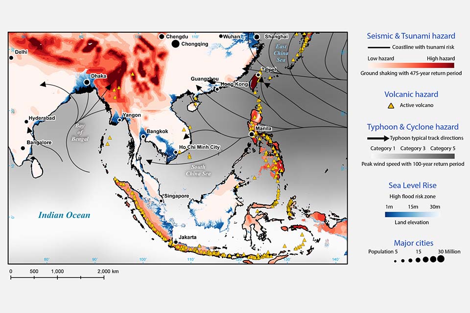
The ASEAN region has experienced multiple geophysical hazards which are not related to climate. These include a series of great earthquakes and tsunamis generated by the Sunda megathrust off the coast of Indonesia (Figure 1), such as the 2004 Aceh-Andaman earthquake which triggered a tsunami that killed more than 230,000 people across 14 countries. Southeast Asia is one of the most volcanically active regions in the world. Over 900 of the region’s volcanoes can produce ash plumes that could impact ASEAN countries and their airspace, causing loss of life, livelihoods, and property, and severely impacting local and regional economies[footnote 4]. For instance, a relatively small eruption of Mount Agung in 2017[footnote 5] disrupted aviation across Indonesia and as far afield as Australia, and the eruption of Mount Sinabung in 2010 displaced at least 12,000 people and erupted volcanic ash and small rocks that damaged nearly 2,500 hectares (25 km2) of agricultural crops[footnote 6].
Transboundary haze is another substantial hazard in Southeast Asia affecting millions in the region[footnote 7]. Small particulate matter from the haze has severe economic and public health impacts for countries in ASEAN. The transboundary haze occurs when fires used to clear lands for agriculture are not controlled. Fires are exacerbated by severe weather events, such as El Niño, when precipitation levels in the region decline. The impacts of transboundary haze have resulted in many impacts on people’s health, ecosystems and the economies of exposed ASEAN nations[footnote 8].
Figure 1: Some of the natural hazards threatening Southeast Asia with location of major cities (Earth Observatory of Singapore, 2015)
2. Compound Hazards in a Warming World
The hazard landscape will be compounded by the threat of climate change in the 21st century.
Climate change has health consequences including temperature-related morbidity and mortality, injuries and deaths from extreme weather events, vector-borne diseases, and undernutrition. These impacts are, however, not evenly distributed across people and places and affect the most vulnerable populations. Climate change also has consequences for ecosystems and agricultural activities because of changes in rainfall patterns and temperature. The Climate Risk Index which computes impacts of extreme weather events has ranked Myanmar (2nd globally), The Philippines (4th) and Thailand (9th) as the top three ASEAN countries at risk over the period 2000-2019 with Brunei Darussalam (176th) and Singapore (179th) being the least at risk ASEAN countries[footnote 9]. The economic impacts of future climate change, if unchecked, will be devastating. Climate change could cut over 35% of the region’s GDP by the middle of the century as it can severely impact key sectors such as agriculture, tourism, and fishing along with human health and labour productivity[footnote 10].
The ASEAN region could shift to a “new climate regime” during the 21st increased: >1°C century. The recent United Nations Intergovernmental Panel on Climate[footnote 11] Change report presents a troubling forecast for ASEAN. As total global warming increases by around 1.5° C in the next two decades, the report predicts that the region will observe hotter weather, longer monsoon seasons, and increased droughts. Recent studies estimate that up to 96% of the ASEAN region is likely to be affected by drought, and up to 64% affected by extreme drought[footnote 12]. Future sea-level rise will affect populations, economies, and infrastructure of every coastal nation. In the coming decades, the greatest effects will be felt in ASEAN, due to the number of people living in low-lying coastal areas. Mainland China, Bangladesh, India, Viet Nam, Indonesia and Thailand are home to the most people on land projected to be below average annual coastal flood levels by 2050[footnote 13]. Together, these six nations account for roughly 75% of the 300 million people on land facing the same exposure to coastal flooding at mid-century. The threat of sea-level rise is further amplified in ASEAN because many coastal regions are sinking due to tectonic processes and the anthropogenic effects of groundwater over-extraction and other natural resources withdrawal[footnote 14].
With many low-lying coastal cities exposed to sea-level rise and tropical cyclone risk, dramatic increases in heat and humidity expected across the region, extreme precipitation predicted in some areas and droughts expected in others, ASEAN societies and economies will be increasingly vulnerable without adaptation and mitigation measures. This vulnerability will be magnified by urban infrastructure that will struggle to cope with a warming world.
3. Assessing Risks to Natural Hazards and Climate Change in ASEAN
ASEAN is highly and unevenly at-risk to natural hazards and climate change because of different hazard characteristics and patterns of exposure and vulnerability.
Risk from natural hazards in ASEAN countries is assessed through the quantification of hazards characteristics, and the exposure and vulnerability of social and ecological systems (Figures 2, 3).
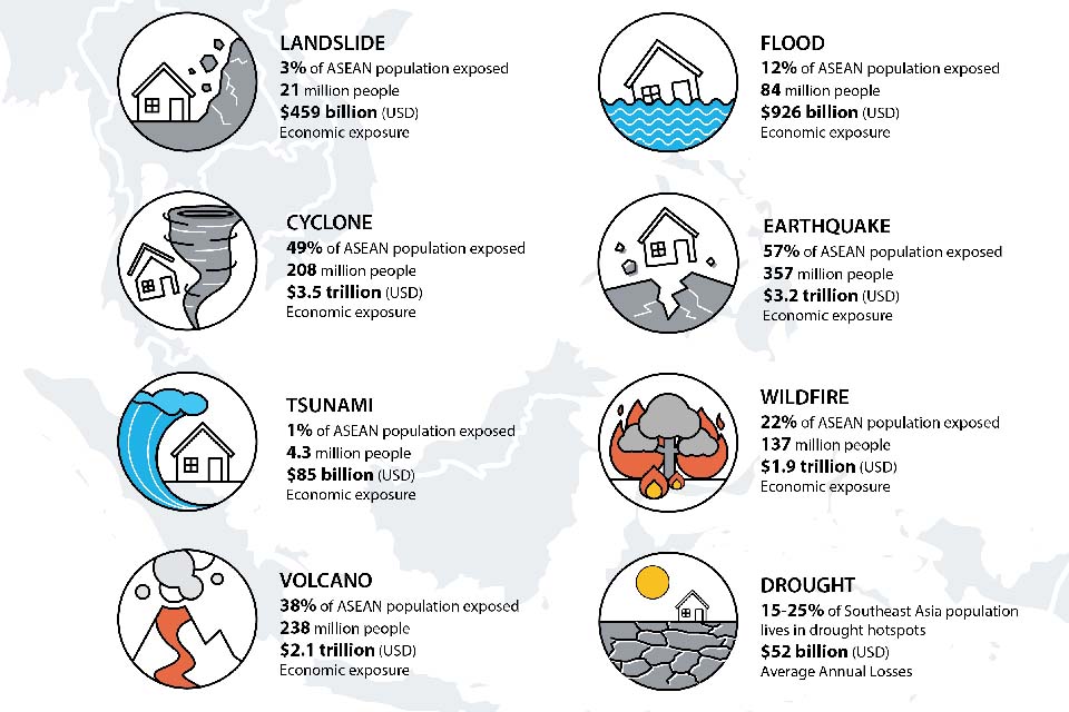
Figure 2: Population and economic exposure to various natural hazards in the ASEAN region
(Source: Landslide, Flood, Cyclone, Earthquake, Tsunami, Wildfire, Volcano data from AHA Centre, 202016; Drought data from UNESCAP, 2021[footnote 17])
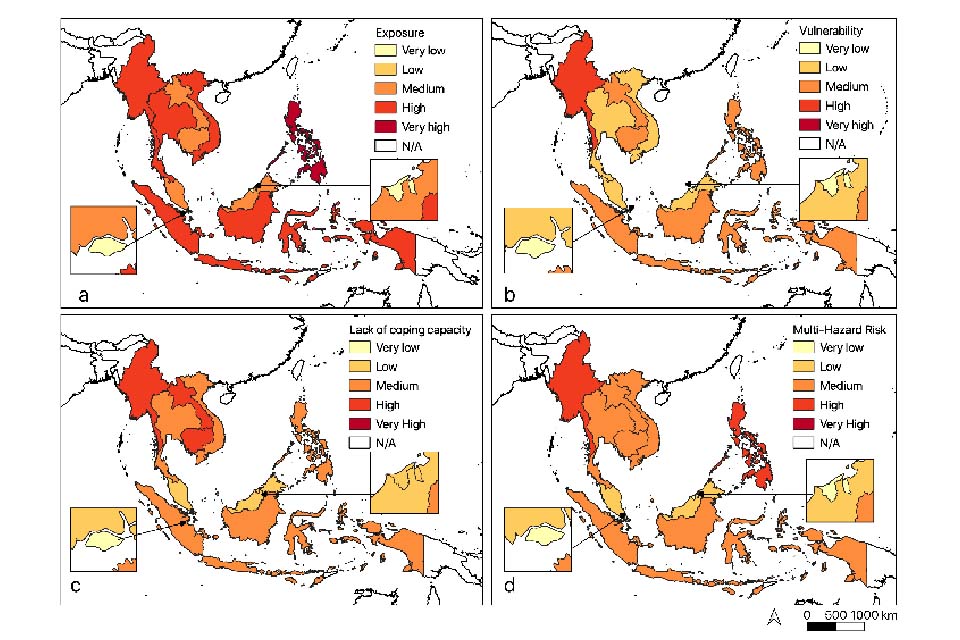
The ASEAN Risk Monitor and Disaster Management Review (ARMOR), which uses a combination of INFORM and the Risk and Vulnerability Assessment framework[footnote 16] shows that the Philippines is the country most exposed to multiple hazards followed by Indonesia, Myanmar, Thailand, and Viet Nam, while Singapore and Brunei Darussalam are the least exposed in the region (Figure 3a). The most vulnerable ASEAN country to multiple hazards is Myanmar followed by the Philippines, Lao PDR, Indonesia, and Cambodia (Figure 3b). The same countries record the least coping capacities (or lack of coping capacity in the figure) albeit in a different order (Figure 3c). Similar to exposure, Singapore and Brunei Darussalam have the lowest vulnerability and highest coping capacities in the region.
Given the patterns of exposure, vulnerability, and lack of coping capacities, it is not surprising that, according to ARMOR, Myanmar and the Philippines are the two countries most at risk from multiple hazards, and Singapore and Brunei Darussalam the least at risk (Figure 3d). Although being less exposed than most other ASEAN countries, Lao PDR and Cambodia are at medium risk from multi-hazards, at the same level as Indonesia, Thailand, and Viet Nam, because of their relatively high vulnerabilities and low coping capacities[footnote 16]. It is important to note that in Asia, countries with lower levels of per capita GDP such as Cambodia, Indonesia, Laos, Malaysia, Myanmar, the Philippines, Thailand, and Vietnam, are most at risk from the impacts of climate change[footnote 15].
Figure 3: Maps of: (a) Exposure to multiple natural hazards, (b) Vulnerability, (c) Lack of coping capacities, and (d) Multi-Hazard Risk in ASEAN countries.
Map of the normalised average of INFORM and RVA V scores (Source: Modified from AHA Centre. 2020[footnote 16])
The WorldRiskReport[footnote 18] has also estimated risks to multiple hazards globally with a national- level resolution. There is both convergence and divergence between the ARMOR and the WorldRiskReport in terms of computed risk levels. Although the approaches and computations between the two reports are different, they both provide information on risk levels and assign countries according to these, from “very low” to “very high”. The biggest divergence, of 4 risk classes (out of 5), is observed for Brunei Darussalam which is characterised as having very low risk by the ARMOR report and very high risk in the WorldRiskReport, the latter classifying the country as the 6th most at risk in the world[footnote 18]. The main difference between the two reports is linked to the level of exposure they compute for Brunei Darussalam (“very high” in the WorldRiskReport and “very low” in ARMOR).
The fact that the two risk frameworks provide identical or similar risk classifications for most ASEAN countries provides additional confidence in terms of risk levels these countries face from multiple hazards. However, the divergent cases should not be ignored because the messages they send can be contradictory and could lead to different disaster risk reduction (DRR) strategies being implemented. In the case of Brunei Darussallam, Ndah and Odihi 2017[footnote 19] noted that the country faced higher risks from hydro-meteorological hazards than is perhaps acknowledged because of a series of factors that include its geographical location, the fact that more localised disasters are under reported, limited knowledge and awareness of the population towards recurrent, low magnitude hazard events and governance issues.
With compound hazards likely to become the norm in the region, it is important to optimise risk assessment tools by trying to understand further the root causes of risk which will vary from country to country. Furthermore, as the impacts of hazards are felt at the local level and adaptation to climate change requires local action, multi-hazard risk assessments should be carried out at the sub-national level to support policymaking and implementation of DRR measures. This is one of the priorities of the ASEAN Agreement on Disaster Management and Emergency Response or AADMER[footnote 20], with the Risk and Vulnerability Assessment (RVA) tool used by ASEAN countries able to characterize risks at the sub-national scale[footnote 21]. Sub-national risk assessments already exist for specific regions or hazards, but a more systematic approach for multi-hazard risk assessment at the sub-national scale would be of great benefit for the ASEAN countries (see e.g., Wannewitz et al., 2016[footnote 22]; Netherland Red Cross, 2021[footnote 23], DRMKC, 2021[footnote 24]). Data availability at the appropriate spatial scale and collection frequency becomes of the essence and any strategy for sub-national risk assessment would have to develop in parallel appropriate data generation and management policies.
4. Diverse Vulnerabilities within and between ASEAN Countries
Assessing vulnerability is essential to develop effective risk reduction and adaptation measures.
4.1. Built environment vulnerability: Building and infrastructure codes, and enforcement of risk-informed building practices
Regulations designed to address past hazards may no longer be adequate in a changing climate and hazard landscape, or with changing standards of living.
Many of the impacts of natural hazards and climate change are mediated through the built environment. For example, floods and earthquakes affect or destroy homes, workplaces, transportation networks and critical infrastructure upon which communities rely on to function. All ASEAN countries have building or construction codes, but the level of safety standards used, their enforcement and implementation vary widely. Recent extreme events have demonstrated the vulnerability of homes in many communities (e.g., Typhoon Haiyan in 2013), or of critical infrastructure (e.g., 2018 dam collapse in Lao PDR). They have also highlighted the extreme high cost of infrastructure repair, reconstruction, and disruption even when loss of life is, in relative terms, small such as for the 2011 Bangkok floods[footnote 25]. Resilience of the built environment will be an important step to ensuring safer communities in ASEAN.
4.2. Ecological vulnerability: Ecosystem services are rapidly being lost
The ASEAN region is one of the most biologically rich regions in the world and its diverse ecosystems provide a wide variety of services essential for human wellbeing. Biodiversity is however under threat.
Ecosystem services help to regulate climate, filter air and water, and mitigate the impact of natural hazards[footnote 26], [footnote 27]. Communities’ livelihoods and wellbeing are more directly related to ecosystem services in rural economies where more than 60% of the population lives in rural areas and 40% works in the agricultural sector (Myanmar, Lao PDR, Cambodia, and Viet Nam). Despite the benefits associated to ecosystem services, biodiversity is in rapid decline in Southeast Asia with 3311 threatened species, due to the loss and the degradation of mangroves, wetlands, coral reefs and tropical forests[footnote 28], [footnote 29], [footnote 30], [footnote 31], [footnote 32]. Drivers of the degradation include urbanization, infrastructure construction, intensive exploitation of natural resources, expansion of monocultures and aquaculture along coasts, inland, on islands, and overfishing offshore. The impact of these development processes can be observed particularly in Indonesia where the deforestation rate is the highest in the region and the country records the highest number of endangered species of mammals, birds and fish in the world[footnote 32]. Habitat loss also involves the loss of ecosystem services which in turn can increase exposure to hazards (e.g., loss of regulating services), reduce adaptive capacities and increase vulnerability (e.g., when procurement services are reduced)[footnote 33].
Figure 4: Environmental Performance Index in ASEAN countries
(Data Source: Wendling et al., 202034; hosted on epi.yale.edu)
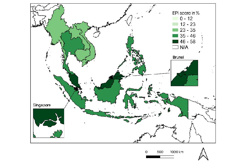
In a context of high pressure over ecosystems, ASEAN states have unequal capacities to implement sustainable development. According to the Environmental Performance Index (EPI, Figure 4), a data-driven summary of the state of sustainability around the world, Brunei Darussalam and Malaysia rank first globally for the protection of terrestrial biome, mainly within effective area-based conservation measures. At the same time, both countries lag far behind in terms of preserving natural ecosystems across their territories[footnote 34]. In general, the index shows that good environmental performances are associated with wealth (GDP per capita), meaning that economic prosperity makes it possible for nations to invest in environmental policies and programmes that lead to desirable outcomes[footnote 34]. Efficient water sanitation is one of them and is well implemented in urban areas of Malaysia, Brunei Darussalam and Singapore[footnote 34]. Beyond the successful implementation of protected areas and water management in the most urbanised countries, according to UNESCAP 2021[footnote 17], the Asia-Pacific region to which ASEAN belongs is far from achieving the Sustainable Development Goals (SDGs) 15 (‘Life on land’) and is regressing in terms of SDG 14 (‘Life below water’) and SDG 13 (‘Climate Action’)[footnote 17].
Policies aiming at achieving the above SDGs must consider the fair and equitable share of ecosystem services for human wellbeing, even if the region’s economy benefits from natural resource exploitation[footnote 27]. In addition, ensuring the effective implementation of laws and regulations by local and national authorities to create positive incentives for sustainable land and resource management can help limit land conversion rates[footnote 35]. Furthermore, integrating ecosystem restoration and NbS (section 7.3) into resource management policies and disaster risk reduction strategies can improve the regulation of ecosystem services. In its recent comprehensive review of the economics of biodiversity, Dasgupta 2021[footnote 36] has highlighted the numerous benefits of NbS that lead to reduced risks, increased climate change mitigation and adaptation, and increased resilience, among many other benefits. Finally, the development of sustainable solutions would greatly benefit from concertation and collaborative work involving local communities and the public and private sectors, engineers, technical personnel, managers, and policy makers.
4.3. Social vulnerability: Poverty, marginalisation, safety-nets
Advances in human development and reducing poverty are highly susceptible to stresses and shocks affecting poorer people the hardest.
The ASEAN region stands out for the progress that all countries have made in advancing human development and reducing poverty over the last 30 years. But the benefits of development have not been evenly distributed, and many people in several parts of the region have been left behind[footnote 37]
Recent evidence suggests that despite reductions in poverty rates, many people remain close to becoming poor and highly vulnerable to shocks38,39. Nutritional security, for example in Cambodia and Lao PDR, has been undermined by high levels of malnutrition, stunting and wasting, especially for women and girls[footnote 40], [footnote 41]. Ethnic minorities across the region tend to be poorer than other population groups according to a range of development indicators. In addition, small- scale farmers suffer significant pressures in production and gaining secure access to markets, and migrant workers who are critical to the labour force of the wealthier countries often work in dangerous professions with weak access to key services and state support. Further, urban populations endure the health and wellbeing impacts of high levels of pollution, and projected increases in urban temperatures.
The experience of the Covid pandemic illustrates how people who have moved out of poverty can easily become poor again[footnote 38]. Moreover, people with limited assets, engaged in precarious or informal employment, and weak access to state support mechanisms, have been especially hard hit[footnote 42]. Poorer people’s strategies to cope with such crises are often short-term focusing on overcoming immediate challenges. But such actions, for example taking girls out of school, reducing food intake, selling assets or borrowing, can have longer-term impacts that undermine future development, and intensify future vulnerability.
Climate change threatens the advances in human development and poverty reduction that ASEAN has made over recent decades. DRR in ASEAN needs to focus on the circumstances, needs and priorities of people who are poor and marginalised (including women, ethnic minorities, disabled and elderly people) and also those who are close to becoming poor as the result of climate stresses, shocks and crises. This will require a suite of policies, including livelihood support, effective emergency relief and social protection, and meaningful participation of vulnerable people.
5. Regional Vulnerabilities in ASEAN
5.1. Livelihoods & food production dependent on environment and climate
The increase in extreme events is of significant concern to ASEAN’s agricultural sector as its productivity depends on a predictable climate and environment.
Natural hazards in ASEAN impact the agricultural sector by damaging physical assets (e.g., standing crops) and infrastructure for agriculture (e.g., irrigation systems, farm equipment and machinery), and through losses in agricultural economic flows (e.g., lower revenues, higher operational costs)[footnote 43]. For example, Typhoon Haiyan in the Philippines submerged crops for ~16 hours and devastated ~600,000 ha of farmland, resulting in 1.1 million tons in crop losses[footnote 44]. Similarly, Cyclone Nargis in Myanmar inundated 1.75 million ha or about 30% of the nationally cultivated wet season rice[footnote 44].
Southeast Asia is also vulnerable to droughts, which have intermittently covered large parts of the region throughout 1981-2020. During the 2015-2016 and 2018-2020 periods, moderate drought conditions affected more than 70% of the land areas. Droughts will continue to negatively affect agricultural land and crops and will affect disproportionally small-scale farmers with less coping capacity[footnote 17].
Agriculture and fisheries in ASEAN are vulnerable to climate change, with low agricultural productivity and low maximum fishing potential[footnote 45]. These impacts are globally significant considering that Southeast Asia supplied ~30% of the world’s rice[footnote 46] and ~22% of the world’s fish in 2018[footnote 47]. Livelihoods and regional food security will be threatened by climate change, with marginal farmers, fishers and poor urban consumers disproportionately affected[footnote 48].
5.2. Urbanisation and economic growth
Strengthening land use planning and ensuring meaningful participation of marginalised urban communities must be a priority.
Urbanisation in flood-prone landscapes, with the construction of roads, housing and factories, has altered the natural hydrology and further intensified flood risks. Flood risk is related to urban planning, but also to the overall river basin management upstream and downstream (see Case Study 3). Construction has often occurred against the advice of official land use plans, with green space and floodplains targeted for urbanisation and industrialisation49. These patterns of change mean that critical public and economic infrastructure, from airports to hospitals, are sometimes located in places that are highly exposed to hazards.
Urban centres and cities are often several degrees warmer than the surrounding rural areas due to what is known as the ‘urban heat island’ effect. This effect results from several factors, including reduced ventilation and heat trapping due to the proximity of tall buildings, heat generated directly by human activities, the heat-absorbing properties of concrete and other urban building materials, and limited vegetation[footnote 50]. Heat stress is expected from the combination of future urban development and more frequent occurrence of extreme climate events, such as heatwaves. Similarly, there is growing evidence that it will be difficult to provide the much- needed water for all uses despite the existing infrastructure such as reservoirs because of climate change and increasing demand[footnote 51].
Climate change requires a more holistic assessment of the impact of shocks and crises on people beyond the location of a particular event because of the interconnectedness of ASEAN cities and economies. The region is increasingly interconnected bringing benefits but also creating fault lines of potential vulnerability with shocks cascading across locations and people. For example, the 2011 floods in Bangkok shut down many factories for several months, disrupting supply chains around the world and reducing demand for labour, which also affected remittances sent by migrant workers to their households in urban and rural areas[footnote 39]. Farmers, processors, distributors, retailers, and consumers are increasingly tied to global food systems that can offer great benefits but have enormous consequences if they fail.
6. Plan, Act, and Finance: How do we reduce risk in ASEAN?
The diversity of contexts, vulnerabilities, and governance structures call for strong mechanisms for ASEAN countries, cities, and communities to learn from and support each other.
6.1. Plan: Preparedness
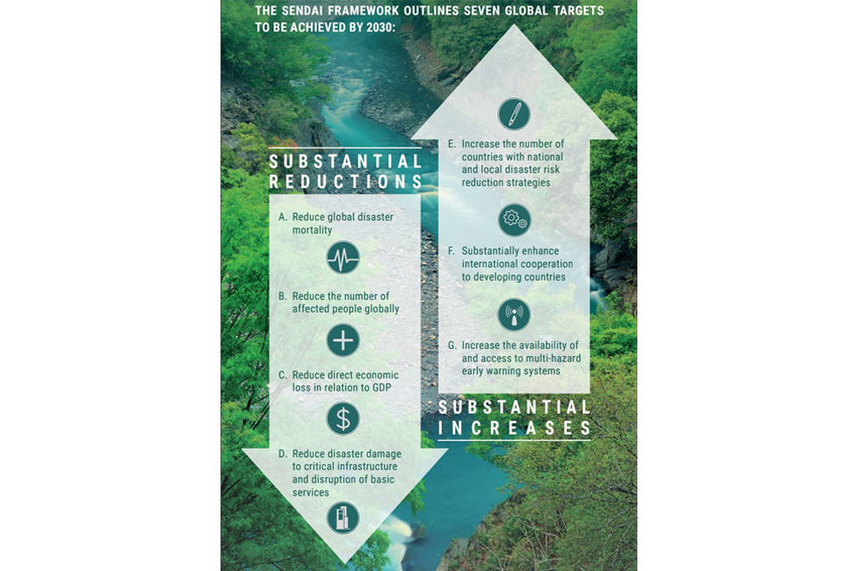
Much progress has been done to better prepare for the effects of climate change, but the lack of reporting prevents a thorough assessment of disaster preparedness in ASEAN. Preparedness is central to the Sendai Framework for Disaster Risk Reduction’s (SFDRR) Priority for Action 4 “Enhancing disaster preparedness for effective response and to “Build Back Better” in recovery, rehabilitation and reconstruction”52. More generally, preparedness is relevant to all seven global targets included in the SFDRR53 and summarised in Figure 5.
Figure 5: The seven global targets included in the Sendai Framework for Disaster Risk Reduction
(Source: UNDRR, 202154)
The SFDRR is a voluntary United Nations agreement, and countries have the opportunity to report progress against the seven global targets annually. Consideration of the SFDRR is included in various regional agreement, including in AADMER. This is a legally binding regional agreement that was signed in 2005 and ratified in 2009 to reduce risks from natural
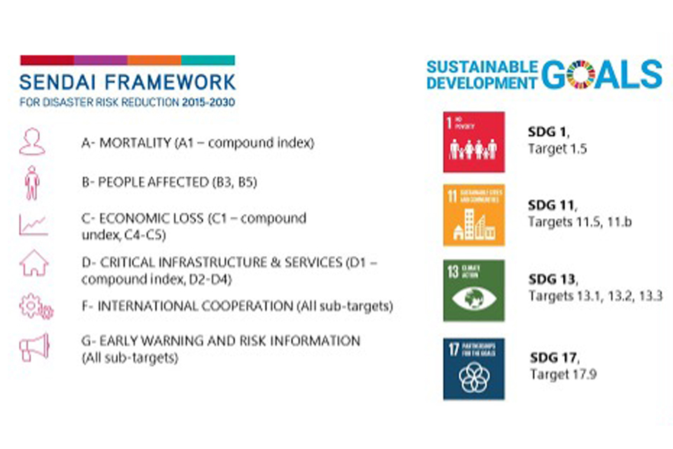
hazards with a focus on regional cooperation. AADMER is currently in its third work programme covering the period 2021-25 with a focus on “[enhancing] and [supporting] ASEAN’s disaster risk reduction and disaster management capabilities”20. Preparedness and response are one of 5 priority programmes for the period 2021-25. Overall, AADMER aims to address six of the seven SFDRR targets and most of the indicators monitored under these targets; as well as targets under four for the 17 Sustainable Development Goals (Figure 6).
Figure 6: SFDRR and SDG targets addressed in the ASEAN Agreement on Disaster Management and Emergency Response
(Source: based on ASEAN, 2020[footnote 20])
According to the Sendai Monitor (2021) the level of reporting against the SFDRR target by ASEAN countries between 2016 and 2020 is very variable and generally low. In terms of disaster- related statistics relevant to the SFDRR, only three ASEAN countries have up-to-date, spatially disaggregated data available in the DesInventar Sendai 2021 database (established to monitor objectives A to D of the SFDRR).
There are many preparedness-related activities in ASEAN as evidenced throughout the latest ARMOR report (AHA Centre, 2020, see also Case Study 1). ASEAN aims to build more resilient governance mechanisms for disaster risk reduction, response and recovery, as well as more coordination between the many groups involved in disaster management in the region[footnote 20], [footnote 55] (Center for Excellence in Disaster Management and Humanitarian Assistance 2015[footnote 55]; ASEAN, 2020[footnote 20]). The effectiveness of the impacts of preparedness activities in terms of reducing risks from natural hazards can be ascertained if adequate monitoring systems are put in place to quantify the indicators used to inform SFDRR and relevant SDG targets and at the same time facilitate the objectives of the ADMEER priority programmes for 2021-25. Such monitoring could be expanded to quantify critical indicators needed for detailed risk assessments at the sub- national scale (see Section 4) thus allowing to address multiple dimensions of risk reduction strategies. The ASEAN Committee on Disaster Management has endorsed the development of the Monitoring and Evaluation System of the AADMER Work Programme 2021-2025. This monitoring system is developed with baseline data collected from the ASEAN Disaster Information Network of the AHA Centre, EMDAT, and ASEAN approved data. It is expected that progress in the implementation of the AADMER Work Programme 2021-2025 can inform ASEAN Member States’ progress in implementing the SFDRR which would be of huge value to inform on the progress achieved through improved preparedness and other policies and actions.
Case study 1: Climate projections and a lack of data
Much remains to be understood about ASEAN and the physical processes that govern it to effectively answer questions about climate change and its societal impacts. The abundance of climate data from the Coordinated Regional Climate Downscaling Experiment (CORDEX), Earth-orbiting satellites, and in situ observations, may close some of these knowledge gaps by directly learning from these large climate science datasets. CORDEX has been understanding ASEAN climate variability and changes and communicating knowledge exchanges with users of regional climate information.
Climate-related hazards, however, still suffer from the so-called “desert of predictability” in the range of two weeks to two months in the future. This time scale, termed “seasonal to sub seasonal”, is critical for preparedness, protecting infrastructure, and/or activate critical institutional processes supporting procurement or resource allocation. The longer the lead time, the easier it is for agencies and NGOs to coordinate and provide optimal responses to imminent disasters.
Although seasonal to sub seasonal models still comprise large uncertainties, they perform particularly well in Southeast Asia, making the region an excellent candidate to benefit from scientific advances in this field. For example, for the devastating floods in Malaysia and Indonesia in February 2016, it was shown that seasonal to sub seasonal models could capture rainfall anomalies up to three weeks in advance. The ASEAN Specialised Meteorological Centre (ASMC), the United Nations Economic and Social Commission for Asia and the Pacific (UNESCAP), the Regional Integrated Multi-Hazard Early Warning System for Africa and Asia (RIMES), and the ASEAN Coordinating Centre for Humanitarian Assistance on disaster management (AHA Centre) are currently developing a pilot programme to improve science-policy integration of such models, a potential game changer for disaster preparedness in the region[footnote 16].
6.2. Acting together with regional and local collaborations
ASEAN needs to foster multi-stakeholder engagement when designing and implementing adaptation and resilience-building initiatives.
Since disasters do not know city or country boundaries, it is important to share resources such as knowledge and funding. The AADMER agreement is an example of regional cooperation with broad objectives, but the region also cooperates on more targeted hazards. Given the importance of drought, for example, several frameworks and cooperation agreements have been published or will be released soon, including the UNESCAP Regional Road Map for Implementing the 2030 Agenda for Sustainable Development in Asia and the Pacific, the ASEAN Declaration on the Strengthening of Adaptation to Drought (2020)[footnote 56] and the upcoming Regional Action Plan of Adaptation to Drought (see UNESCAP, 2020[footnote 12] for a full list). Addressing hazard risks efficiently can only be achieved by understanding the entire system under consideration and its spatial and temporal heterogeneity. Trying to reduce risks by acting locally (e.g., by building local infrastructure) will likely be insufficient. A landscape approach should be considered to identify clearly both the sources of the problems and the solutions. Actions at the regional or local level, such as improving sea-level rise monitoring (Case Study 2) or multi-stakeholder action to reduce flood risk (Case study 3) and respond to disasters (Case study 4), would need to involve collaboration between states, and states and non- governmental actors.
Case study 2: Sea-level rise in ASEAN
Global sea level rose faster in the 20th century than in any of the 27 previous centuries, and observations and projections suggest that it will rise at a higher rate during the 21st century. Rising sea levels increase the vulnerability of cities and associated infrastructure that line many of the ASEAN coastlines because of higher extreme sea levels (and flooding), coastal erosion, surface and ground water salinization, and coastal habitat degradation.
Global sea level is rising primarily because global temperatures are rising, causing ocean water to expand and land ice to melt. However, sea-level rise is not uniform; it varies from place to place (relative sea-level rise). In ASEAN, it shows significant variability that depends on the combination of global mean sea-level rise and regional factors, such as ocean and atmospheric circulation patterns, the gravitational and deformational effects of land ice mass changes, and tectonic vertical land motion. The relative influence of these regional factors determines whether rates of local sea-level change are higher or lower than the global mean, and by how much14.
Key to informed policy decisions for resilient future communities in ASEAN is the ability to predict relative sea-level rise and understand the potential consequences on infrastructure and natural ecosystems on which coastal communities depend. However, future projections of sea-level rise in ASEAN are uncertain, because of limitations in tide gauge observations and proxy reconstructions. The spatial coverage of tide gauges is patchy, less than 50 years in length and many records are ‘contaminated’ by inadequately understood vertical land motion. Proxy reconstructions of relative sea-level rise on multi-decadal to millennial scales are restricted to one location in Southeast Asia, further precluding the assessment of regional driving processes[footnote 57].
ASEAN needs to build its own scientific community that can meet the region’s need for understanding global and regional sea-level rise and extreme sea levels. For example, the National Sea Level Programme aims to coordinate relevant climate research in Singapore with institutes of higher learning and address key knowledge gaps in the understanding and modelling of the physical mechanisms of sea level rise and variability, with specific focus on Singapore and the wider ASEAN region. There is an opportunity to leverage the capacities of the UK’s COP26 Universities network to work alongside ASEAN partners to address this gap.
Case Study 3: Landscape approach to reduce flood risk in Jakarta
The city of Jakarta in Indonesia suffers recurrently from major floods that have serious impacts on people and the economy. There were 11 major flood events recorded in the Emergency Events Database (EM-DAT) from 1996 to 2021. Flooding in Jakarta is due to a variety of natural and anthropogenic factors[footnote 58], [footnote 59]: Jakarta is located on a delta formed by the Ciliwung river and therefore has a flat topography and is affected by tidal processes from the Java Sea. The city is intersected by 13 rivers, including the Ciliwung river. The steep and narrow Ciliwung watershed exceeds 3,000 mm of rainfall annually, with the rainy season (especially January-February) being particularly intense. Jakarta also suffers from high rates of land subsidence (~ 3 to 10 cm/year[footnote 58]) mainly due to rapid population growth, urban development, and poor water management, which result in excessive groundwater extraction. The problem of land subsidence is extremely serious and is one of the many factors that led to the decision to move the capital to the island of Kalimantan. In addition, Jakarta suffers from poor urban and land use planning with an inadequately designed drainage system. The watershed is experiencing high rates of land-use change, with forest cover and rice cultivation being replaced by urban infrastructure and dryland agriculture, contributing to an increase in the frequency of recurrent flooding[footnote 59], [footnote 60].
Efforts to reduce flood risk at the city level are important, including plans for the development of a giant sea wall off the coast of Jakarta, but any isolated action will be insufficient unless a landscape perspective is taken. Indonesia has a highly decentralized governance system that makes collaboration between administrative regions difficult due to competition for financial resources[footnote 59]. Therefore, to reduce flood risk, it is not only important to understand all processes at the catchment scale, but also to establish mechanisms that enable cross-administrative negotiations between regions, which could, for example, lead to the establishment of compensation mechanisms between upstream and downstream areas that benefit everyone[footnote 59]. Single localized actions will likely fail to address the flood problem sustainably.
Many ASEAN deltas are exposed to multiple hazards and specifically to flooding, such as the Irrawaddy delta in Myanmar, the Mekong delta in Viet Nam, the Chao Phraya delta in Thailand, all of which were classified as “in peril” or “in greater peril” (from flooding) by Syvitski et al. 2009[footnote 61]. Addressing up-stream and downstream processes is important for these deltas too, albeit at much larger scales than for the Ciliwung river delta, and the negotiations between different actors sometimes needs to be carried out in an international context. Several research partnerships between UK and academic institutions and other stakeholders in ASEAN addressing issues related to the sustainability of deltas exist already (e.g., https://www.livingdeltas.org/) and should be further developed in the future to address this global challenge problem.
Case study 4: The role of Institutes of Higher Learning
Early warning systems can be placed in high-risk areas to closely monitor the region and take immediate action before a hazard strikes. For example, satellites and technologies for surveillance and early warning can be used to identify wildfire hotspots and take immediate action to address the hazards, which may also potentially lead to major local and transboundary haze problems in the region.
The field of disaster risk management relies heavily on technical information about where, when, and how disasters can occur, so scientific and technical knowledge is critical. Institutes of Higher Learning (IHLs) have an important role to play in this context as they contribute to generating, collating, and sharing knowledge that enable community members and their leaders to take relevant, cost-effective action. The Earth Observatory of Singapore’s ARIA-SG programme (https://earthobservatory.sg/project/aria-sg-project) has supported regional and local stakeholders and decision makers by developing cutting-edge algorithms to monitor and map regional hazards, environmental crises, and natural disasters. The ARIA-SG project has provided disaster maps to help with rescue and recovery efforts for more than 25 disasters over the last few years, working with the Changi Regional HADR Coordination Centre (RHCC), the ASEAN Coordinating Centre for Humanitarian Assistance on disaster management (AHA), Sentinel Asia, regional NGOs and government agencies. For example, it provided flood extent maps of the 2019 Laos floods to AHA, which were used by AHA and the Laos authorities to plan rescue efforts and estimate the necessary volume of relief supplies.
Despite benefits of scientific and technical knowledge from IHLs, limitations and potential dangers of should be highlighted. For example, there are mounting calls to stop “parachute science”, referring to a practice where researchers collect local data and publish papers without involving local researchers or communities. This unethical practice exacerbates the gap between low- and high-income countries and is highly ineffective when it comes to action-oriented research because it disregards contextual knowledge that is critical to disaster risk management practice. Another important limitation relates to researcher priorities and mandates. Incentivising researchers to engage further in action-oriented collaboration will help optimise resources and effectively improve disaster risk management in the region.
6.3. Act: Leveraging Nature-based Solutions
Nature-based solutions (NbS) can complement grey infrastructure to reduce disaster risk if they are carefully designed and implemented.
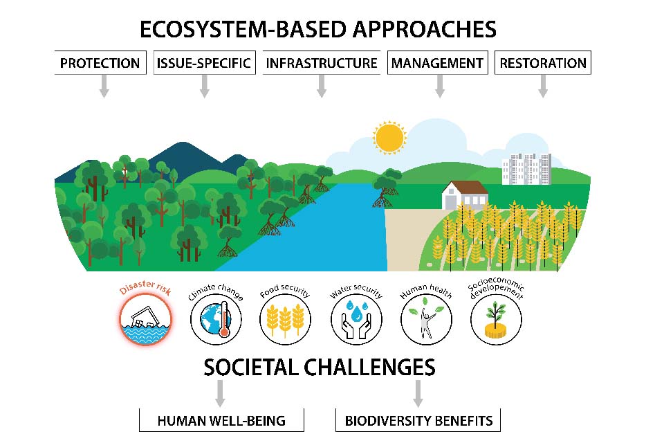
Nature-based solutions are defined as “actions to protect, sustainably manage, and restore natural or modified ecosystems, that address societal challenges effectively and adaptively” (Figure 7) simultaneously providing human well-being and biodiversity benefits[footnote 62]. A recent joint report by IPCC and IPBES (Intergovernmental Platform on Biodiversity and Ecosystem Services) concludes that the biodiversity and the climate crises are intrinsically linked and so are the actions we need to take to solve them[footnote 28].
Figure 7: Nature-based Solutions can help address one or more societal challenges, such as disaster risk, while delivering biodiversity benefits
(Adapted from: IUCN, 2020[footnote 62])
After the 2004 Indian Ocean tsunami, a debate ensued as to the role mangroves might have played in reducing the impact of the tsunami waves; this role has probably not been significant. However, the importance of the heavily impacted coastal mangrove forests came to the fore because of many other factors. Due to the destruction of mangrove forests by the tsunami, large-scale broad-brush planting efforts were initiated across Asia as a direct response to bring back and enhance coastal green belts. However, many of these well-intended projects were not beneficial for people or biodiversity. Single-species mass planting on exposed tidal flats to avoid land ownership disputes and quickly meet target numbers did not consider inclusive governance or adaptive management, nor did it consider nature conservation principles to achieve biodiversity gains[footnote 62]. This was in addition to an often-inadequate ecological understanding of the bottlenecks to mangrove survival, resulting in futile financial efforts in many countries. Thanks to lessons learned from previous restoration projects and the rapid emergence of new guidance for NbS, specifically for coastal vegetation management and restoration, there is now a growing awareness of how to implement successful projects, although challenges remain (Case study 5).
Case study 5: Challenges and opportunities for mangrove forest management in Viet Nam
Viet Nam’s healthy mangroves make important contributions to both climate change adaptation and mitigation, by acting as a natural barrier against storms, sea-level rise, and erosion, and by storing and sequestering carbon. Mangroves form a natural habitat for many aquatic and terrestrial species and provide a source of livelihood for coastal communities. Unless managed well, the complex overlays of different interests around mangroves, resource uses, and ecological processes will lead to conflict, with subsequent environmental, socioeconomic, and cultural trickle effects.
Viet Nam’s mangrove forests have declined rapidly, in both area and quality. Mangrove forests have dwindled due to uncontrolled wood extraction, agricultural expansion, mining activities, construction of dikes, dams, and roads, and most importantly commercial shrimp farming. As a result, the area under mangrove cover reduced by 36% in 29 years[footnote 64]. The loss of mangrove areas has increased exposure and vulnerability of the coast to tidal surges and hurricanes and has increased coastal salinity[footnote 65].
The Government of Viet Nam now recognizes the need to protect the remaining mangrove forests, but success is slow to materialize[footnote 66]. Local people have been asked by the government to manage the mangroves, but the request has not yet been widely heeded. One of the main reasons mangroves have been in decline and mangrove replanting programs have had mixed successes in Viet Nam over the past century is that the benefits and burdens of mangrove protection are not shared equally. The real social pressures on mangroves have rarely been addressed in any replanting programme Viet Nam also lacks direct regulatory responses to mangrove degradation and loss[footnote 67]. Mangroves are managed and protected through various forest, aquaculture, and conservation policies rather than through a specific mangrove policy[footnote 67].
To promote the sustainable management of mangroves, which can significantly contribute to disaster risk reduction and climate change adaptation, more equitable and appropriate policies are needed at the country’s commune and district levels. Such policies should be suitable for the local cultural and geographical conditions, and they should benefit most of the villagers, in particular marginalized groups. These policies would need to consider factors such as political power, economic heterogeneity within the commune, institutional arrangements for allocating resources, the implementation of property regimes, conflict resolution, economic and social incentives, and the cultural, historical, and geographical specificity of local communities. Kim Son district in the Red River Delta could serve as a benchmark for future mangrove conservation and restoration activities. There, strong local commons institution and collective actions have greatly contributed to successful mangrove management at the local level.
By following ecological principles, tackling land-use trade-offs early on, understanding landscape processes, and most importantly, by engaging with the local guardians of these carbon rich and biodiverse habitats, mangrove restoration can support future sustainable livelihoods and, in the case of certain coastal hazards and/or in combination with engineered structures, can significantly contribute to disaster risk reduction for coastal communities. One example of several in the region is the combination of mangrove restoration with light-engineered structures and land use planning to reduce and reverse severe coastal erosion and associated flooding in north central Java, Indonesia[footnote 63]. Greater understanding of the impact of climate change on these ecosystems is however required as they will all be affected and their adaptation could be curtailed.
6.4. Finance: Learning from global advances in disaster risk financing
The majority of disaster losses are still uninsured. Disasters risk financing initiatives should be transparent, accountable and regulated, and focus on building preparedness and resilience.
Governance mechanisms for managing risk reflect local and national legal and institutional frameworks and are mediated by financial capacity for risk management. The diversity of experiences with managing risk and the diversity of governance mechanisms within ASEAN can be an opportunity to learn from, adapt and/or adopt successful interventions.
Factors related to governmental institutions influence all other causes of hazard vulnerability. Effective cooperation between governmental authorities and civil society involves poor and marginalised people in decision-making and information exchange (vertical cooperation). In addition, cooperation between government agencies, private sector, and other stakeholders, such as non-governmental organisations and the academia, can result in multiple benefits.
Financing is an important part of disaster risk management strategies, as recognised by the SFDRR and other major international agreements (Paris Agreement, SDGs, Addis Ababa Action Agenda). Annual economic losses from natural hazards are substantial in Asia-Pacific and are expected to reach USD 160 billion by 2030, but only a small share of those (8%) is insured[footnote 68]. For example, less than 9% of the USD 900 million economic losses incurred in the January 2020 floods in Indonesia were insured[footnote 10]. Mirroring the global interest in disaster risk financing, including the recent uptake in climate finance instruments, and given the high returns on investments expected from resilience-building activities in Southeast Asia which range in terms of cost-benefits analyses from approximately 1:1.8 (e.g., for 5- to 7-day typhoon forecasts that facilitate the early harvest of crops in Thailand) to 1:55 (mangrove planting programmes in eight provinces of Viet Nam to protect against the impacts of typhoons)[footnote 69], new initiatives have recently emerged in the region. ASEAN’s Disaster Risk Financing and Insurance plan of action entered its Phase 2 in 2019, promoting risk assessment, risk advisory, and capacity building in the region. The Asian Development Bank’s Integrated Disaster Risk Management Fund was established in 2013 to support regional disaster risk management projects. The World Bank also recently launched the first regional risk financing facility in Asia, the Southeast Asia Disaster Risk Insurance Facility (SEADRIF). Its first financial product is a flood risk pooling mechanism for Lao PDR, Myanmar, and Cambodia.
Despite these recent initiatives, projects involving public, private, and multilateral banks, at the scale needed to significantly reduce risk and address the protection gap, remain very scarce, as many of the initiatives above still focus on capacity building and strengthening fiscal management and governance. These efforts are important since transparency, accountability, and enforcement of standards and regulations are necessary to the implementation of financial instruments. However, they should be considered as a first step: a way to better distribute funding between disaster response, recovery and (more cost-effective) preparedness and resilience-building efforts.
Greater visibility of government planning for disaster risk reduction, adaptation and resilience- building would allow to further incentivise investment in these domains. It would also provide clarity on expected compound risk trajectories at the national and regional levels which would also improve the confidence for long-term investments in adaptation. Communication could be through relevant sectoral bodies, centres and entities associated with ASEAN Secretariat, but also by individual countries through the adaptation Communication Mechanism of the Paris Agreement.
Glossary of key terms
| Adaptation | is the “process of adjustment to actual or expected climate and its effects. In human systems, adaptation seeks to moderate or avoid harm or exploit beneficial opportunities. In some natural systems, human intervention may facilitate adjustment to expected climate and its effects”[footnote 70]. |
| Compound Hazards | is “(…) the combination of multiple drivers and/or hazards that contributes to societal or environmental risk (adapted from Zscheischler et al., 2018[footnote 71]). |
| Coping Capacity | is the “ability of people, institutions, organizations, and systems, using available skills, values, beliefs, resources, and opportunities, to address, manage, and overcome adverse conditions in the short to medium term”[footnote 70]. |
| Disaster Risk Management | is the application of disaster risk reduction policies and strategies to prevent new disaster risk, reduce existing disaster risk and manage residual risk, contributing to the strengthening of resilience and reduction of disaster losses[footnote 72]. |
| Disaster Risk Reduction | is aimed at preventing new and reducing existing disaster risk and managing residual risk, all of which contribute to strengthening resilience and therefore to the achievement of sustainable development[footnote 72]. |
| Exposure | is the situation of people, infrastructure, housing, production capacities and other tangible human assets located in hazard-prone areas[footnote 72]. |
| Preparedness | is the knowledge and capacities developed by governments, response and recovery organizations, communities and individuals to effectively anticipate, respond to and recover from the impacts of likely, imminent or current disasters[footnote 72]. |
| Resilience | is the capacity of social, economic, and environmental systems to cope with a hazardous event or trend or disturbance, responding or reorganizing in ways that maintain their essential function, identity, and structure, while also maintaining the capacity for adaptation, learning, and transformation[footnote 70]. |
| Risk | is the potential for consequences where something of value is at stake and where the outcome is uncertain, recognizing the diversity of values. (…) Risk results from the interaction of vulnerability, exposure, and hazard[footnote 70]. |
| Vulnerability | is the conditions determined by physical, social, economic and environmental factors or processes which increase the susceptibility of an individual, a community, assets or systems to the impacts of hazards[footnote 72]. |
Acknowledgements
Each of the four vital and timely COP26 ASEAN policy reports would not have been possible without the support and coordination of the British High Commission and COP26 Universities Network. We especially like to thank the authors of the Nature-based Solutions, report for the ongoing collaboration, comments received on previous drafts, and support throughout the process. This research was supported by the National Research Foundation Singapore and the Singapore Ministry of Education under the Research Centres of Excellence initiative, and by the Nanyang Technological University. Finally, thank you to Ms Phuong Nguyen, Ms Yvonne Soon and Ms Mei Ting Law of the Earth Observatory of Singapore for their help with formatting the final report.
Photo Credit: Earth Observatory of Singapore – Lauriane Chardot, Joanne Petrina, Luo Yizhou; Shutterstock - Bernhard Staehli, Dani Daniar, Ares Jonekson
-
The AHA Centre. ASEAN Risk Monitor and Disaster Management Review (ARMOR). Jakarta: ASEAN Coordinating Centre for Humanitarian Assistance on disaster management (AHA Centre), https://ahacentre.org/wp-content/uploads/2019/05/FINAL-ARMOR-2019-AHA-CENTRE.pdf (2018) ↩
-
Soria, J. L. A. et al. Repeat Storm Surge Disasters of Typhoon Haiyan and Its 1897 Predecessor in the Philippines. Bulletin of the American Meteorological Society 97, 31-48 (2016). ↩
-
UNESCAP. The Disaster Riskscape across South-East-Asia: Key Takeaways for Stakeholders. (2020). ↩
-
Jenkins, S. F., Magill, C. & Blong, R. Evaluating relative tephra fall hazard and risk in the Asia- Pacific region. Geosphere 14, 492-509 (2018). ↩
-
ADRA Indonesia & HelpAge International. Risk Analysis Report: Mt. Agung Volcano, Bali, Indonesia. (2017). ↩
-
Tampubolon, J., Nainggolan, H. L., Ginting, A. & Aritonang, J. Mount Sinabung Eruption: Impact on Local Economy and Smallholder Farming in KaroRegency, North Sumatra. IOP Conference Series: Earth and Environmental Science 178, 012039 (2018). ↩
-
Lee, J. S. H. et al. Toward clearer skies: challenges in regulating transboundary haze in Southeast Asia. Environmental Science & Policy 55, 87-95 (2016). ↩
-
Sunchindah, A. Transboundary haze pollution problem in Southeast Asia: Reframing ASEAN’s response. (2015). ↩
-
Eckstein, D., Künzel, V. & Schäfer, L. GLOBAL CLIMATE RISK INDEX 2021 (2021). ↩
-
Swiss Re. From the ground up: Tackling the secondary perils protection gap in the Asia Pacific, https://www.swissre.com/risk-knowledge/mitigating-climate-risk/tackling-secondary-perils- protection-gap-in-apac.html (2021). ↩ ↩2
-
IPCC. Climate Change 2021: The Physical Science Basis. Contribution of Working Group I to the Sixth Assessment Report of the Intergovernmental Panel on Climate Change. Cambridge University Press. (2021). ↩
-
UNESCAP. Ready for the Dry Years: Building resilience to drought in South-East Asia with a focus on Cambodia, Lao People’s Democratic Republic Myanmar and Vietnam: 2020 update. (2020). ↩ ↩2
-
Kulp, S. & Strauss, B. H. New elevation data triple estimates of global vulnerability to sea-level rise and coastal flooding. Nature Communications 10 (2019). ↩
-
Horton, B. P. et al. Mapping sea-level change in time, space, and probability. Annual Review of Environment and Resources 43, 481-521 (2018). ↩
-
UNESCAP. Ready for the dry years. Building resilience to drought in South-East Asia (2021). ↩ ↩2 ↩3 ↩4
-
AHA Centre. ASEAN Risk Monitor and Disaster Management Review (ARMOR) 2nd edition. Jakarta: ASEAN Coordinating Centre for Humanitarian Assistance on disaster management (AHA Centre), https://ahacentre.org/publication/armor/ (2020). ↩ ↩2 ↩3 ↩4
-
McKinsey Global Institute. Climate risk and response in Asia (2021). ↩
-
Bündnis Entwicklung Hilft. WorldRiskReport 2020 (2020). ↩ ↩2
-
Ndah, A. B. & Odihi, J. O. A systematic study of disaster risk in Brunei Darussalam and options for vulnerability-based disaster risk reduction. International Journal of Disaster Risk Science 8, 208-223 (2017). ↩
-
ASEAN Secretariat. ASEAN Agreement on Disaster Management and Emergency Response (AADMER) Work Programme 2021-2025 (2020). ↩ ↩2 ↩3 ↩4
-
Bell, H., Bausch, D., Morath, D. & Livengood, J. ASEAN Regional Risk and Vulnerability Assessment Guidelines. (2017). ↩
-
Wannewitz, S., Hagenlocher, M. & Garschagen, M. Development and Validation of a Sub-national Multi-hazard Risk Index for the Philippines. GI_Forum - Journal for Geographic Information Science 1, 133-140 (2016). ↩
-
Netherland Red Cross. Community Risk Assessment Dashboard, https://dashboard.510.global/#!/ (2021). ↩
-
DRMKC. Inform Subnational model of Myanmar, https://drmkc.jrc.ec.europa.eu/inform-index/ INFORM-Subnational-Risk/Myanmar (2021). ↩
-
The World Bank. Thai Flood 2011: Rapid Assessment for Resilient Recovery and Reconstruction Planning (2012). ↩
-
UNDRR. Global Assessment Report on Disaster Risk Reduction (2019). ↩
-
Dang, A. N., Jackson, B., Benavidez, R. & Tomscha, S. A. Review of ecosystem service assessments: Pathways for policy integration in Southeast Asia. Ecosystem services 49, 101266 (2021). ↩ ↩2
-
Pörtner, H. O. et al. IPBES-IPCC co-sponsored workshop report on biodiversity and climate change (2021). ↩ ↩2
-
Hansen, M. C. et al. High-Resolution Global Maps of 21st-Century Forest Cover Change. Science 342, 850 - 853 (2013). ↩
-
Bunting, P. et al. The Global Mangrove Watch - A New 2010 Baseline of Mangrove Extent. Remote Sensing 10, 1669 (2018). ↩
-
Hughes, A. C. Understanding the drivers of Southeast Asian biodiversity loss. Ecosphere 8 (2017). ↩
-
IUCN. The IUCN Red List of Threatened species. Version 2021-2, http://www.iucnredlist.org (2021). ↩ ↩2
-
Shah, M. A. R. et al. A review of hydro-meteorological hazard, vulnerability, and risk assessment frameworks and indicators in the context of nature-based solutions. International Journal of Disaster Risk Reduction 50, 101728 (2020). ↩
-
Wendling, Z. A., Emerson, J. W., de Sherbinin, A., Esty, D. C., et al. 2020 Environmental Performance Index. Yale Center for Environmental Law & Policy, https://epi.yale.edu/ (2020) ↩ ↩2 ↩3
-
UNEP-WCMC. The State of Biodiversity in Asia and the Pacific: A mid-term review of progress towards the Aichi Biodiversity Targets. (2016). ↩
-
Dasgupta, P. The Economics of Biodiversity: The Dasgupta Review (2021). ↩
-
Bhatkal, T. & Mariotti, C. Who is Being Left Behind in Asia? An Illustration in Bangladesh and Vietnam (2016). ↩
-
Chaparro, C. O., L., and Sethuraman, K. Overview of the Nutrition Situation in Seven Countries in Southeast Asia (2014). ↩
-
Vilain, C., Baran, E., Gallego, G. & Samadee, S. Fish and the Nutrition of Rural Cambodians. Asian Journal of Agriculture and Food Sciences 4 (2016). ↩
-
Sumner, A., Ortiz-Juarez, E. & Hoy, C. Precarity and the pandemic: COVID-19 and poverty incidence, intensity, and severity in developing countries (2020). ↩
-
ADB. Key Indicators for Asia and the Pacific 2021, 52nd Edition (2021). ↩
-
FAO. The impact of disasters on agriculture and food security (2021). ↩
-
Lassa, J. A., Lai, A. Y.-H. & Goh, T. Climate extremes: an observation and projection of its impacts on food production in ASEAN. Natural Hazards 84, 19-33 (2015). ↩ ↩2
-
Thiault, L. et al. Escaping the perfect storm of simultaneous climate change impacts on agriculture and marine fisheries. Science Advances 5 (2019). ↩
-
IRRI. Transitioning toward equitable, profitable, and environmentally sound rice agri-food systems (2021). ↩
-
SEAFDEC. Total Fishery Production in Southeast Asia, <http://www.seafdec.org/fishstat2018/ (2015). ↩
-
Caballero-Anthony, M., Teng, P., Tian, G., Shrestha, M. & Lassa, J. Linking Climate Change Adaptation and Food Security in ASEAN. In ERIA Discussion Paper Series. S. Rajaratnam School of International Studies-Nanyang Technological University (RSIS-NTU). (2015). ↩
-
Siman, K. et al. Nature-based Climate Solutions for Climate Mitigation: Challenges and Opportunities for the ASEAN Region. UK Government, UK-Singapore COP26 ASEAN Climate Policy Report Series (2021). ↩
-
Friend, R. & Thinphanga, P. Urban water crises under future uncertainties: the case of institutional and infrastructure complexity in Khon Kaen, Thailand. Sustainability 10, 3921 (2018). ↩
-
Yang, J. W., Shiyao; Dewina,Reno. Taking the Pulse of Poverty and Inequality in Thailand. World Bank Group. (2020). ↩
-
Center for Excellence in Disaster Management and Humanitarian Assistance. ASEAN Disaster Management Reference Handbook. (2015). ↩ ↩2
-
ASEAN. The ASEAN Declaration on the Strengthening of Adaptation to Drought , https://asean.org/the-asean-declaration-on-the-strengthening-of-adaptation-to-drought/ (2020). ↩
-
Meltzner, A. J. et al. Half-metre sea-level fluctuations on centennial timescales from mid-Holocene corals of Southeast Asia. Nature Communications 8 (2017). ↩
-
Abidin, H., Andreas, H., Gumilar, I. & Wibowo, I. On correlation between urban development, land subsidence and flooding phenomena in Jakarta. Proceedings of the International Association of Hydrological Sciences 370, 15-20 (2015). ↩ ↩2
-
Asdak, C., Supian, S. & Subiyanto. Watershed management strategies for flood mitigation: A case study of Jakarta’s flooding. Weather and climate extremes 21, 117-122 (2018). ↩ ↩2 ↩3 ↩4
-
Remondi, F., Burlando, P. & Vollmer, D. Exploring the hydrological impact of increasing urbanisation on a tropical river catchment of the metropolitan Jakarta, Indonesia. Sustainable Cities and Society 20, 210-221 (2016). ↩
-
Syvitski, J. P. M. et al. Sinking deltas due to human activities. Nature Geoscience 2, 681-686 (2009). ↩
-
IUCN. Global Standard for Nature-based solutions. A user-friendly framework for the verification, design and scaling up of NbS. (2020). ↩ ↩2 ↩3
-
Quinn, C. et al. Unpacking Changes in Mangrove Social-Ecological Systems: Lessons from Brazil, Zanzibar, and Vietnam. Resources 6, 14, doi:10.3390/resources6010014 (2017). ↩
-
Pham, H. T., Nguyen, T.T.H., Lai, T.T & Mai, S.T. Vulnerability to climate change of mangorve forests in Northern Vietnam. In Proceedings of the six national academic conference on ecology and biological resources. (2015). ↩
-
Le, H. Competing for Land, Mangroves and Marine Resources in Coastal Vietnam, 1st edition. (2021). ↩
-
Orchard, S., Stringer, L. C. & Quinn, C. H. Environmental entitlements: institutional influence on mangrove social-ecological systems in Northern Vietnam. Resources 4, 903-938 (2015). ↩ ↩2
-
Wilms, T., Van der Goot, F., Tonneijck, F., Nurhabni, F., Sembiring, L. Building with Nature Approach. Building with Nature to restore eroding tropical muddy coasts. Ecoshape technical report (2020). ↩
-
UNESCAP. Disaster Risk Financing: Opportunities for Regional Cooperation in Asia and the Pacific (2019). ↩
-
ADB. Investing in Resilience: Ensuring a Disaster-Resistant Future. (2013). ↩
-
IPCC. Annex II: Glossary. In: Climate Change 2014: Synthesis Report. Contribution of Working Groups I, II and III to the Fifth Assessment Report of the Intergovernmental Panel on Climate Change. IPCC, Geneva, Switzerland, pp. 117-130. (2014) ↩ ↩2 ↩3 ↩4
-
Zscheischler, J. et al. Future climate risk from compound events. Nature Climate Change 8, 469- 477, doi:10.1038/s41558-018-0156-3 (2018). ↩
-
UNDRR. Terminology, https://www.undrr.org/terminology (2021). ↩ ↩2 ↩3 ↩4 ↩5