Particles in the Environment Update - Q4 2022
Published 20 January 2023

© Crown copyright 2023
This publication is licensed under the terms of the Open Government Licence v3.0 except where otherwise stated. To view this licence, visit nationalarchives.gov.uk/doc/open-government-licence/version/3 or write to the Information Policy Team, The National Archives, Kew, London TW9 4DU, or email: psi@nationalarchives.gov.uk.
Where we have identified any third party copyright information you will need to obtain permission from the copyright holders concerned.
This publication is available at https://www.gov.uk/government/publications/particles-in-the-environment-annual-report-update-q4-2022/particles-in-the-environment-update-q4-2022
1. Progress and areas monitored
During 2022 a total area of 117 ha of the beaches along the Cumbrian coast were monitored against a programme target of 105 ha.
A total of 49 particles and 7 larger objects (1) were detected, recovered and analysed, details are given in table 1.
The 2022 monitoring programme included an additional 0.85 ha of monitoring in January 2022 to support the response to an elevated reading on filter change (02 December 2021), no finds were detected or recovered during this survey.
Strandline surveys of the upper beach between Drigg and St. Bees were completed in March and September with no beach finds being reported.
Further details of the programme can be found in the annual report series (2).
2. Find rates
Average find rates were compared with find rates over the last 2 calendar years in table 2 and the last 4 years in figure 1. For clarity of presentation, the find rates in table 2 were rounded to the nearest significant figure.
Table 2 and figure 1 shows that Alpha-rich particle³, Beta-rich particle and Beta-rich larger object find rates at Sellafield beach were comparable with the average find rates from the previous years.
Alpha-rich particle find rates at northern beaches and southern beaches were comparable with those measured at those areas in recent years.
Find rates in 2022 did not require any form of intervention through the Environment Agency’s Sellafield radioactive objects notification and intervention plan (4).
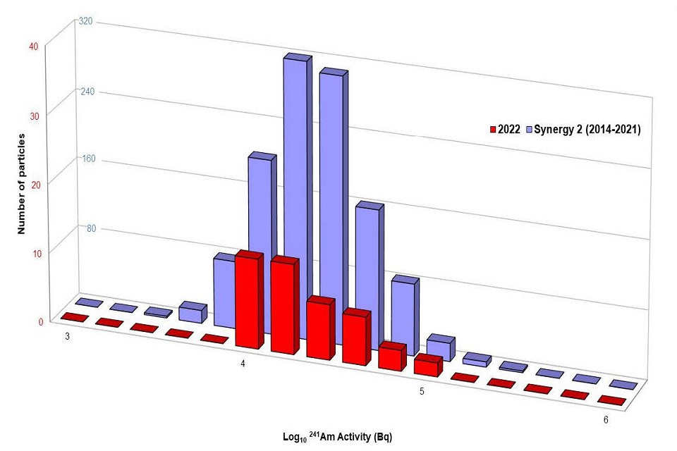
3. Find activities
Figure 2 shows the activities of Alpha-rich particles, Beta-rich particles and Beta-rich larger objects were comparable to the activities measured since May 2014 (when the current version of the monitoring equipment was introduced).
None of the finds recovered in 2022 required characterisation through the Environment Agency’s Sellafield radioactive objects notification and intervention plan (5).
4. Summary of programme
Table 3 presents a summary of the beach monitoring programme since it started in 2006. Overall, a total of 2707 ha of beaches have been monitored and 3,488 particles and larger objects have been recovered and analysed.
5. Conclusion
The UK Health Security Agency risk assessment for radioactive particles and larger objects on West Cumbrian beaches reported that
- overall health risks for beach users are very low, and significantly lower than other risks that people accept when using the beaches
- measures to control these risks are not warranted on public health grounds
5.1 Note:
- Particles are finds < 2 mm in diameter and “larger objects” are finds >= 2mm in diameter (includes: granules, gravel, pebbles, stones etc.)
- [https://www.gov.uk/government/collections/sellafield-ltd-environmental-and-safety-reports[(https://www.gov.uk/government/collections/sellafield-ltd-environmental-and-safety-report)
- Alpha-rich are finds with 241 Am activity greater than 137 Cs activity, “Beta-rich” are finds with 137 Cs activity greater than 241 Am activity and “Co-60 rich” are finds with positive 60 Co activity greater than the 137 Cs activity.
- https://www.gov.uk/government/publications/sellafield-radioactive-objects-notification-and-intervention-plan/sellafield-radioactive-objects-notification-and-intervention-plan
6. Table 1: Beach finds in 2022
| Beach location | Areas covered (ha) | No. of particles found Alpha-rich | No. of particles found Beta-rich | No. of particles found other | No. of particles found not analysed | No. of larger objects found Alpha-rich | No. of larger objects found Beta-rich | No. of larger particles found other | No. of larger objects found not analysed | Total finds |
|---|---|---|---|---|---|---|---|---|---|---|
| Allonby | 5 | 0 | 0 | 0 | 0 | 0 | 0 | 0 | 0 | 0 |
| Northern beaches | 35 | 11 | 0 | 0 | 0 | 0 | 0 | 0 | 0 | 11 |
| Sellafield | 55 | 30 | 2 | 1 | 0 | 0 | 7 | 0 | 0 | 40 |
| Southern beaches | 22 | 5 | 0 | 0 | 0 | 0 | 0 | 0 | 0 | 5 |
| All | 117 | 46 | 2 | 1 | 0 | 0 | 7 | 0 | 0 | 56 |
Note 1 - Proportion of particles as % of total finds 88%
7. Table 2 : Find per hectare and area monitored for main beach areas
| Beach location | Year | Area covered (ha) | Find category and type (finds per hectare) alpha-rich particle | Find category and type (finds per hectare) beta-rich particle | Find category and type (finds per hectare) beta-rich larger object | Find category and type (finds per hectare) other finds |
|---|---|---|---|---|---|---|
| Allonby | 2020 | 6 | 0 | 0 | 0 | 0 |
| 2021 | 5 | 0 | 0 | 0 | 0 | |
| 2022 | 5 | 0 | 0 | 0 | 0 | |
| Northern beaches | 2020 | 30 | <1 | 0 | 0 | 0 |
| 2021 | 36 | 2 | 0 | 0 | 0 | |
| 2022 | 35 | <01 | 0 | 0 | 0 | |
| Sellafield | 2020 | 58 | <1 | <0.1 | <0.1 | 0 |
| 2021 | 57 | <1 | <0.1 | <0.1 | 0 | |
| 2022 | 55 | <1 | <0.1 | <1 | <0.1 | |
| Southern beaches | 2020 | 19 | <0.1 | 0 | 0 | 0 |
| 2021 | 24 | <0.1 | 0 | 0 | 0 | |
| 2022 | 22 | <1 | 0 | 0 | 0 |
7.1 Note 2:
- IA - Insufficient area coverage to estimate finds rates (<10 ha)
- N/A - No monitoring to date
- “<1” denotes values between 0.1 and 0.99
- “<0.1” denotes values between zero and 0.099
- Other find relates to a single 10 kBq Co-60 rich particle detected and recovered on 17 October 2022.
8. Table 3: Summary of beach monitoring data since programme began in 2006
| Beach location | Area (ha) | Total particle | Total larger object | Alpha-rich particle | Alpha-rich larger object | Beta-rich particle | Beta-rich larger object | Co-60 rich particle | Co-60 rich larger object |
|---|---|---|---|---|---|---|---|---|---|
| Allonby | 124 | 18 | 1 | 16 | 0 | 2 | 1 | 0 | 0 |
| Northern beaches | 904 | 878 | 0 | 821 | 0 | 51 | 0 | 6 | 0 |
| Sellafield | 999 | 1701 | 727 | 1362 | 6 | 330 | 719 | 9 | 2 |
| Southern beaches | 604 | 137 | 6 | 112 | 0 | 25 | 4 | 0 | 2 |
| Other beaches | 78 | 19 | 1 | 17 | 0 | 2 | 1 | 0 | 0 |
| All | 2707 | 2753 | 735 | 2328 | 6 | 410 | 725 | 15 | 4 |
8.1 Note:
Northern beaches are St Bees and Braystones, southern beaches are Seascale and Drigg. Allonby and Sellafield are included specifically.
All other beaches (e.g. Whitehaven, Workington, Silecroft etc.) are incorporated into the “other beaches” definition.
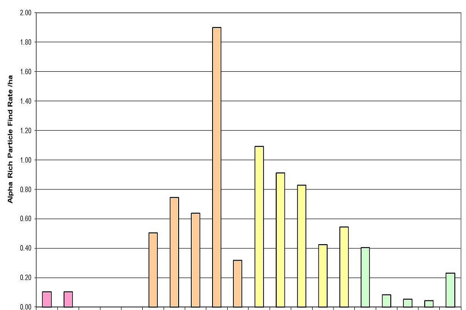
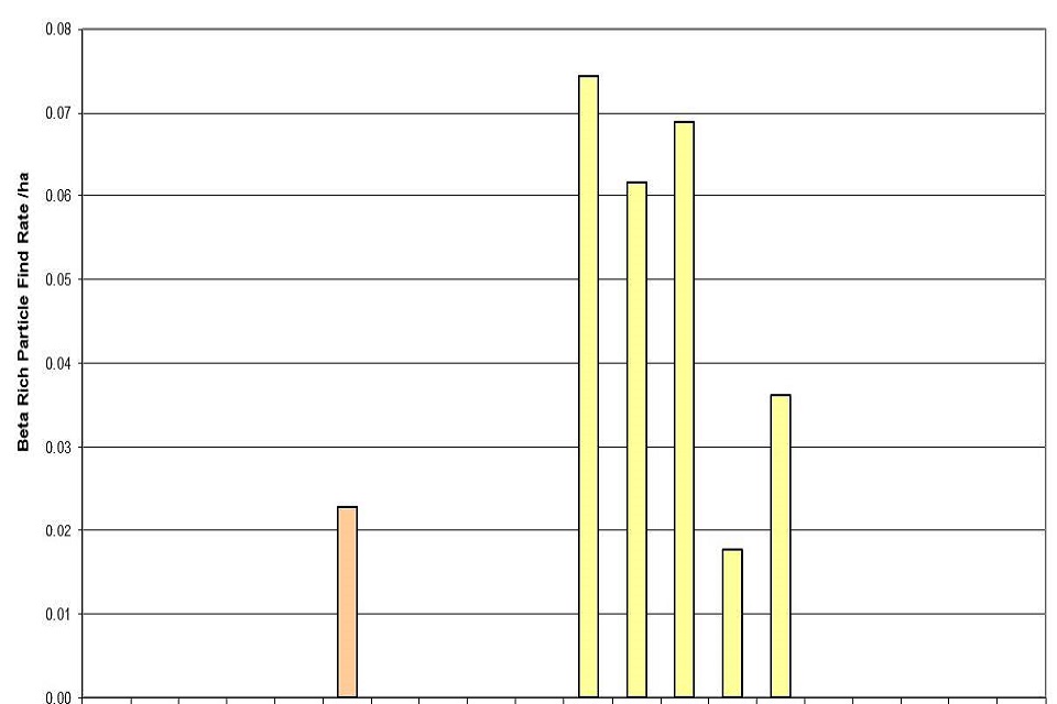
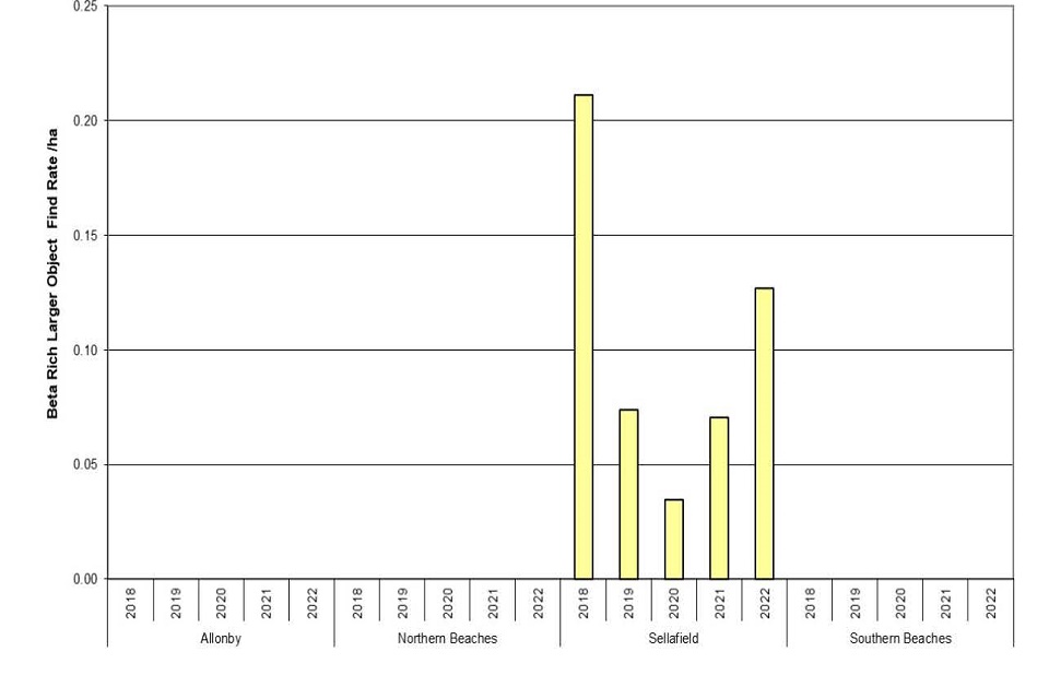
Figure 1: Find rates of alpha-rich particles (upper), beta-rich particles (middle) and beta-rich larger objects (lower) between 2018 to 2022.
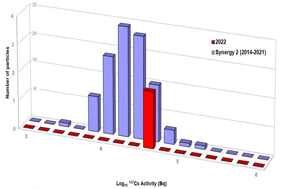
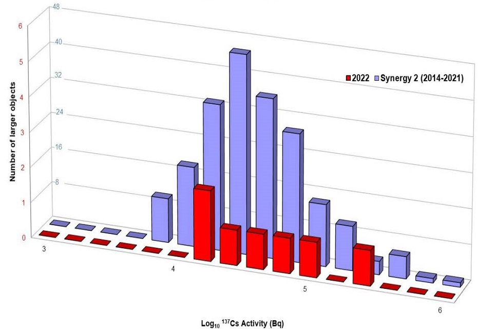
Note 3: Different scales used for 2022 and Synergy2 datasets.
Figure 2: Radioactivity of finds classified as alpha-rich particles between May 2014 to December 2021 (termed “Synergy2” and shown in blue) compared to data from 2022 (termed “2022” and shown in red).