Land use statistics in England: methodology changes
Published 16 September 2026
Applies to England

© Crown copyright 2026
This publication is licensed under the terms of the Open Government Licence v3.0 except where otherwise stated. To view this licence, visit nationalarchives.gov.uk/doc/open-government-licence/version/3 or write to the Information Policy Team, The National Archives, Kew, London TW9 4DU, or email: psi@nationalarchives.gov.uk.
Where we have identified any third party copyright information you will need to obtain permission from the copyright holders concerned.
This publication is available at https://www.gov.uk/government/consultations/land-use-statistics-in-england-methodology-changes/land-use-statistics-in-england-methodology-changes
This consultation seeks views on a proposed new methodology for the Land Use in England (stock) and Land Use Change statistics.
Scope of this consultation
We are considering how best to rebuild the land use statistics on Ordnance Survey’s National Geographic Database in a way that meets user needs. The consultation presents our proposed approach and seeks views on its key features and implications.
Geographical scope
These proposals relate to statistics for England only.
Impact assessment
An impact assessment is not required as this is a technical consultation relating to the department’s production of statistics.
Body responsible for the consultation
Ministry of Housing, Communities and Local Government (MHCLG).
Duration
This consultation will run for 6 weeks from 16 September 2026 to 28 October 2026.
Enquiries
If you have any questions about the consultation, email planning.statistics@communities.gov.uk
How to respond
You can respond to the consultation by completing the online survey.
Summary
This consultation seeks views on a new methodology for the department’s land use statistics for England. These statistics describe how England’s land is used — how much is residential, agricultural, woodland, transport and so on — and how that is changing over time, including how much new residential development takes place on different land types.
The statistics are currently published up to 2022 and are built on data that Ordnance Survey (OS) is retiring. The data’s replacement, the National Geographic Database (NGD), is a richer and more detailed picture of England’s land, but it is fundamentally different from the old data, and the statistics cannot be produced from it using the existing method.
We are therefore rebuilding the methodology while using this opportunity to modernise the statistics rather than replicate the old approach on new data.
The refresh also responds to growing demand for land use evidence — including the recently published Land Use Framework for England, government housebuilding ambitions and the rollout of clean energy infrastructure — which the statistics as last published were not designed to serve.
We plan to resume publication of the land use statistics this year (2026), with the first tranche of releases covering the years 2024 to 2026.
This consultation seeks views on our proposals to rebuild the land use statistics on the new data, focusing on the choices most likely to matter to users:
- a new, more detailed set of land use categories
- a break in the time series, meaning the new statistics should not be directly compared with those published up to 2022
- the schedule on which the new and resumed publications will appear
1. Introduction
This document invites comments on MHCLG proposals for the future production of its land use statistics.
The land use statistics comprise 3 related releases:
Land Use in England (‘land use stock’)
An annual snapshot of how England’s land is used, broken down by category at national and local authority level, in both proportion and total hectarage, including breakdowns for the Green Belt and areas of flood risk. Last published for 2022.
Land use change: new residential addresses
An annual release showing the proportion of new residential addresses created on each land use type as per that year’s land use stock snapshot, including the proportion of new addresses created on previously developed land. Last published for 2022-23 based on the 2022 land use stock snapshot.
Land use change: hectarage
A release every 3 years mapping how much land has moved between different use types. Last published in 2022 covering the 3 financial years from 2019-20 to 2021-22.
The statistics are used across and beyond government. They are used for:
- monitoring planning policy outcomes
- preparing and examining Local Plans
- academic research
- informing discussion and decision-making about how England’s land is used
All 3 releases are accompanied by open data tables breaking the data down to local authority level, as well as at Middle/Lower Super Output Area level for the land use stock release.
The department last consulted on these statistics in 2019. That consultation established the current shape of the series - annual land use stock and new residential address statistics, and triennial hectarage change statistics.
The proposals in this consultation assume a continuation of this publication rhythm, and focus on changes needed to the underlying methodology because of the introduction of Ordnance Survey’s (OS) National Geographic Database (NGD) as the primary data source used for the construction of the statistics.
Question 1
What is your name?
Question 2
What is your email address?
Question 3
Which user group do you fit into?
- central government
- local government
- planner
- developer
- industry
- academic
- media
- campaign group
- community group
- consultant
- member of the public
- other
(Select all that apply)
Question 4
What do you use the land use statistics for currently?
Question 5
How often do you use the following statistics?
- Land use in England statistics
- Land use change: new residential addresses statistics
- Land use change: hectarage statistics
(Weekly / Monthly / Annually / Never)
2. Why the methodology needs updating
The statistics published up to 2022 were produced from bespoke data prepared for the department by OS based on their MasterMap and AddressBase products. Every parcel of land in England was placed into 1 of 28 categories (the ‘LUCS categories’ - see Annex A) designed in 2004, with each category classed as ‘developed’ or ‘non-developed’. Further information on the LUCS categories is available.
Since 2022, OS has been in the process of replacing its suite of individual products with the NGD, which represents the most comprehensive spatial dataset currently available and covers the whole of Great Britain. The NGD offers more frequent updates, greater analytical flexibility, richer attribution, and a larger and more contemporary set of land use categories maintained by OS itself.
The pre-2022 methodology used to produce the land use statistics cannot simply be re-run on the new NGD data. The LUCS categories do not exist natively in the NGD, and the underlying data differs in fundamental ways: the detail at which land is mapped, the way OS determines what land is used for, and the way related features are grouped together. Attempting to reverse-engineer the old categories from the new data would create a misleading impression of continuity while being less accurate, and less transparent.
The change of data source is not the only reason to refresh these statistics. In March 2026 the department for Environment, Food and Rural Affairs published England’s first Land Use Framework, setting out how the country’s finite land can deliver its objectives on housing, food security, clean energy and nature recovery together. The framework explicitly commits to the publication of updated land use stock statistics as part of building a wider evidence base for how land is currently being used across England.
More generally, there is wider recognition that our existing taxonomies have not kept pace with how England’s land is actually used. In 2023, the Geospatial Commission’s National Land Data Programme reviewed the data available to support land use decision-making and found that current classifications, including the LUCS categories, do not fully capture the range of demands now placed on land, from renewable energy to nature recovery to new forms of mixed-use development.
We are therefore proposing to rebuild the statistics using the NGD data, using OS’s own classification, and to present the results as a new series starting from 2024. The new series will at minimum offer the same set of spatial aggregations, intersections and breakdowns into smaller geographies as the legacy series.
Section 3 sets out the new approach, Section 4 what it means for the land use change statistics, Section 5 what it means for comparability with the statistics published up to 2022, and Section 6 the publication plan for the first tranche of releases under the new approach.
3. The proposed new approach
3.1 A new taxonomy
We propose to publish the statistics using OS’s own land classification rather than the 28 LUCS categories used in the legacy series.
This classification is built into the new data itself: OS assigns every piece of land both a use (what activity takes place on it, for example residential, retail, education) and a cover (what it physically is for example grassland, trees or water) using a 2-level Tier A/Tier B hierarchy.
Publishing using OS’s classification means the statistics are directly traceable to the source data, with no translation layer maintained by the department in between, and anyone with access to the data can reproduce the published figures.
Adopting the OS Tier A/B classification would align the land use statistics with the wider direction of travel across government. The NGD’s land use data and classifications are used across central, devolved and local government, including by the Environment Agency and the Rural Payments Agency. NGD data is available free at the point of use to public sector organisations under the Public Sector Geospatial Agreement, so situating the new series and classification taxonomy within this emerging and interoperable infrastructure aligns with the Land Use Framework’s ambition to achieve better consistency and usability of foundational land data across the public sector.
Our baseline proposal is to use the OS Land Use Tier A categories as a replacement for the LUCS classes, striking a balance between improving on the granularity of the old series and keeping the total number of categories manageable for communication and interpretability purposes.
In addition, we also propose to incorporate:
1. Additional discrete classes for residential gardens and solar installations
These features are not part of the base Tier A taxonomy, but the rich attribution of the NGD allows their presence to be inferred from elsewhere in the data. Residential gardens are included on the basis that they are part of the legacy LUCS categories; solar panels are included in recognition of the increasing importance of land as a resource for clean energy generation, and in response to requests from users in the 2019 land use consultation to include them as separate categories.
2. A subset of ‘borrowed’ land cover classes
To serve as the classifier for areas of land with no clear use, such as non-agricultural woodland and grassland. Using the Tier A land use classes only would result in these features (representing a substantial proportion of land in England) being classed as simply ‘unknown or unused natural’. Drawing on land cover information in these cases as an alternative allows for a more informative breakdown.
The approach of combining land use and land cover into a single list described above mirrors that of the LUCS categories used in the legacy series. An alternative option would be to publish parallel breakdowns, with every piece of land in England shown once by use and once by cover. However, the nature of land use and land cover means that one classification is most informative precisely where the other is not; where land doesn’t have a clear use (for example, a natural woodland) the cover is the attribute of interest, but where it does (for example, a school) the reverse is true. A single combined taxonomy therefore gives every piece of land its most meaningful single label.
A full list of the proposed new classes can be found in Annex B.
Question 6
Do you support the proposal to adopt Ordnance Survey’s classification in place of the previous 28 categories as shown in Annex B?
- yes
- no
If no, explain why.
Question 7
Do you support continuing to present land use and land cover as a single combined list of categories, as now, rather than as 2 separate breakdowns?
- yes
- no
If no, explain why.
Question 8
Are there specific land uses not separately identified in the proposed categories in Annex B that you would want to see published as their own category if feasible?
- yes
- no
If yes, explain why.
3.2 A top-down approach to defining land use
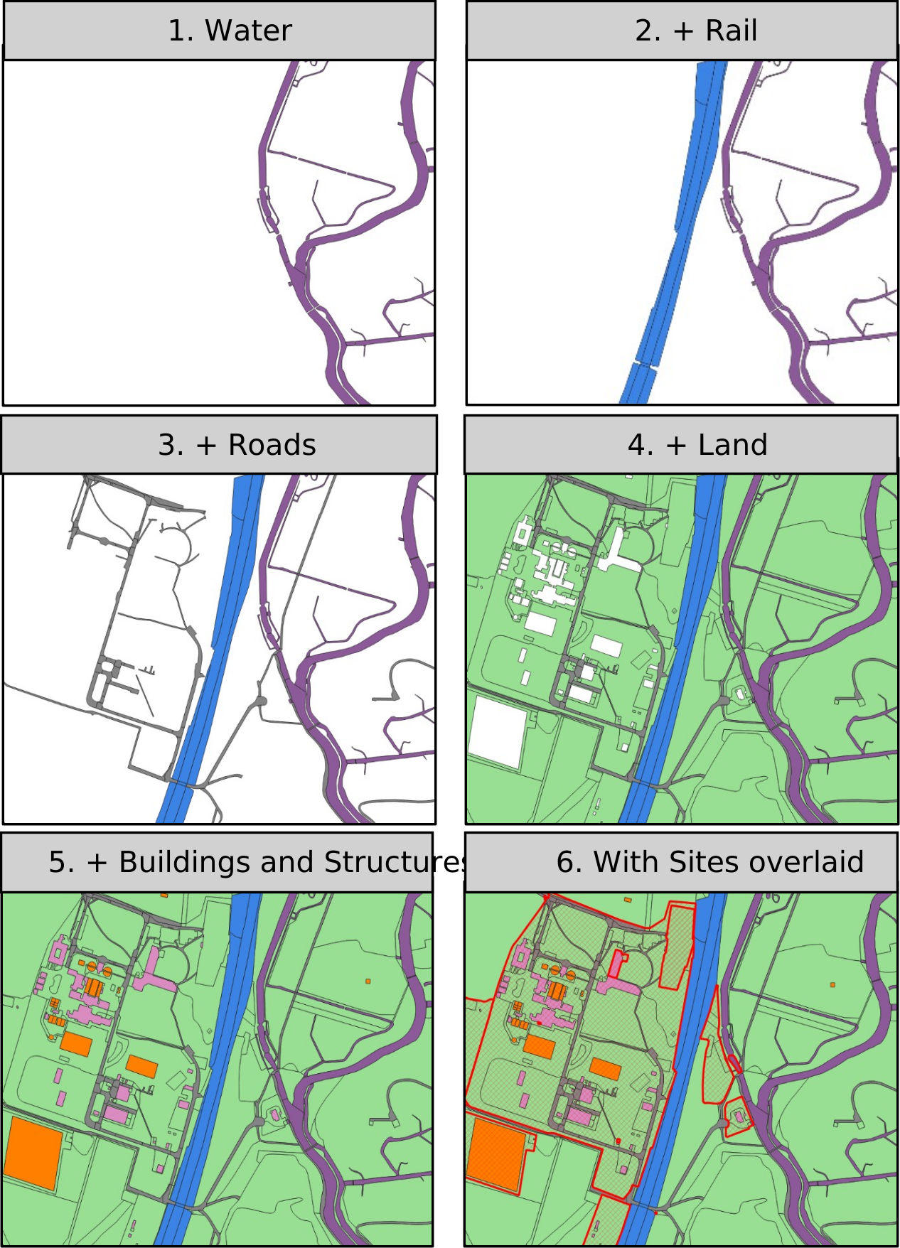
The NGD data can describe England in extremely granular detail — separating out individual buildings, gardens and curtilage into distinct features. While in some cases this may be the most helpful way to consider the uses of a given area of land, in many cases those individual features form part of a recognisable real-world site, such as a school or hospital. The NGD’s Sites data layer identifies such cases where multiple features contribute to an overall land use and groups them accordingly under a single use. Our view is that this ‘top-down’ approach best reflects how users think about land use in the real world, and we therefore propose that in cases where a feature is part of a site, it inherits that site’s Tier A land use class.
In cases where a feature is part of multiple nested sites (for example, a university campus containing a research cluster that contains a laboratory building), it inherits the Tier A land use class of the largest site. Where land is not part of any identifiable site, it is classified by its own use, and where no use is known, by its land cover type, as described above. Figure 1 provides a visual representation of how the 5 core NGD layers combine to give full coverage of an example area, and how they interact with the Sites layer sitting on top of them.
Figure 1
Figure 1 is a combination of each NGD layer to build up a full picture of all features. Each layer fills in a unique subset of the land area, with the exception of the Sites layer (shown in red) which aggregates other layers into groups based on their collective land uses.
Question 9
Do you agree that features within a recognisable site, such as a school or hospital, should be classified as a whole using the land use of the largest site that contains them rather than by their individual uses?
- yes
- no
If no, explain why.
3.3 Defining developed and non-developed land
Each of the legacy LUCS categories was fundamentally classed as either developed or non-developed, broadly equating to definitions of ‘brownfield’ and ‘greenfield’ land respectively. This attribution is particularly important for the Land Use Change: New Residential Addresses release, one of the headline metrics of which is a comparison of the proportion of new addresses created on developed vs. non-developed land.
OS’s Tier A land use and land cover classifications carry no such attribution, so we propose to determine it ourselves, provisionally on a category-by-category basis.
To remain as close as possible to the spirit of the LUCS categories, we have done this with reference to the National Planning Policy Framework, which defines ‘previously developed land’ as:
Land which has been lawfully developed and is or was occupied by a permanent structure and any fixed surface infrastructure associated with it, including the curtilage of the developed land (although it should not be assumed that the whole of the curtilage should be developed). It also includes land comprising large areas of fixed surface infrastructure such as large areas of hardstanding which have been lawfully developed. Previously developed land excludes: land that is or was last occupied by agricultural or forestry buildings; land that has been developed but where provision for restoration has been made through development management procedures (including development related to minerals extraction, waste disposal by landfill and renewable and low carbon energy development, where provision for restoration exists); land in built-up areas such as residential gardens, parks, recreation grounds and allotments; and land that was previously developed but where the remains of the permanent structure or fixed surface structure have blended into the landscape.
A full list of the proposed classes along with their provisional developed and non-developed attribution resulting from our interpretation of the NPPF definition above can be found in Annex B.
Assigning developed/non-developed status at category level in a way that is both accurate and keeps the total number of categories to a reasonable level requires trade-offs that were also a feature of the LUCS categories. For example, the ‘Sports Facilities’ category may contain features relating to football stadia (developed) and outdoor pitches (non-developed). We welcome stakeholder views on this and similar edge cases ahead of publication.
Question 10
Do you agree with the proposed developed/non-developed split, as shown in Annex B?
- yes
- no
If no, please explain why.
4. Implications for the land use change statistics
The proposals set out above concern in the first instance the core land use stock publication, but this also forms the foundation for the 2 change releases, and the new methodology carries through to both.
4.1 Land use change: new residential addresses
The core approach of this release — taking each year’s new residential addresses and overlaying them on the previous year’s land use stock data — will not fundamentally change, with address information drawn from the NGD’s Address layer rather than the legacy AddressBase product.
What will change is the baseline it draws on: the previous land use of each new address will be reported against the new OS Tier A-based categories, and the release’s headline measure — the proportion of new addresses created on previously developed/non-developed land — will be based on the assignments discussed above and shown in Annex B.
Another meaningful change concerns the treatment of vacant land. In the legacy series, vacant land was assigned to its own LUCS class (V). By contrast, the OS Tier A/B land use classes don’t include vacant land as an explicit category; instead, such land is classified according to its last known use prior to becoming vacant. This will impact the presentation of the new residential address statistics, because historically ‘vacant (previously developed)’ and ‘vacant (not previously developed)’ have been the LUCS classes with the largest number of new addresses. In the new series, addresses that would have previously been grouped as such will instead be distributed among the ‘active’ land use categories that make up the OS Tier A taxonomy. ‘Vacant’ will therefore cease to exist as a separate land classification in the new series.
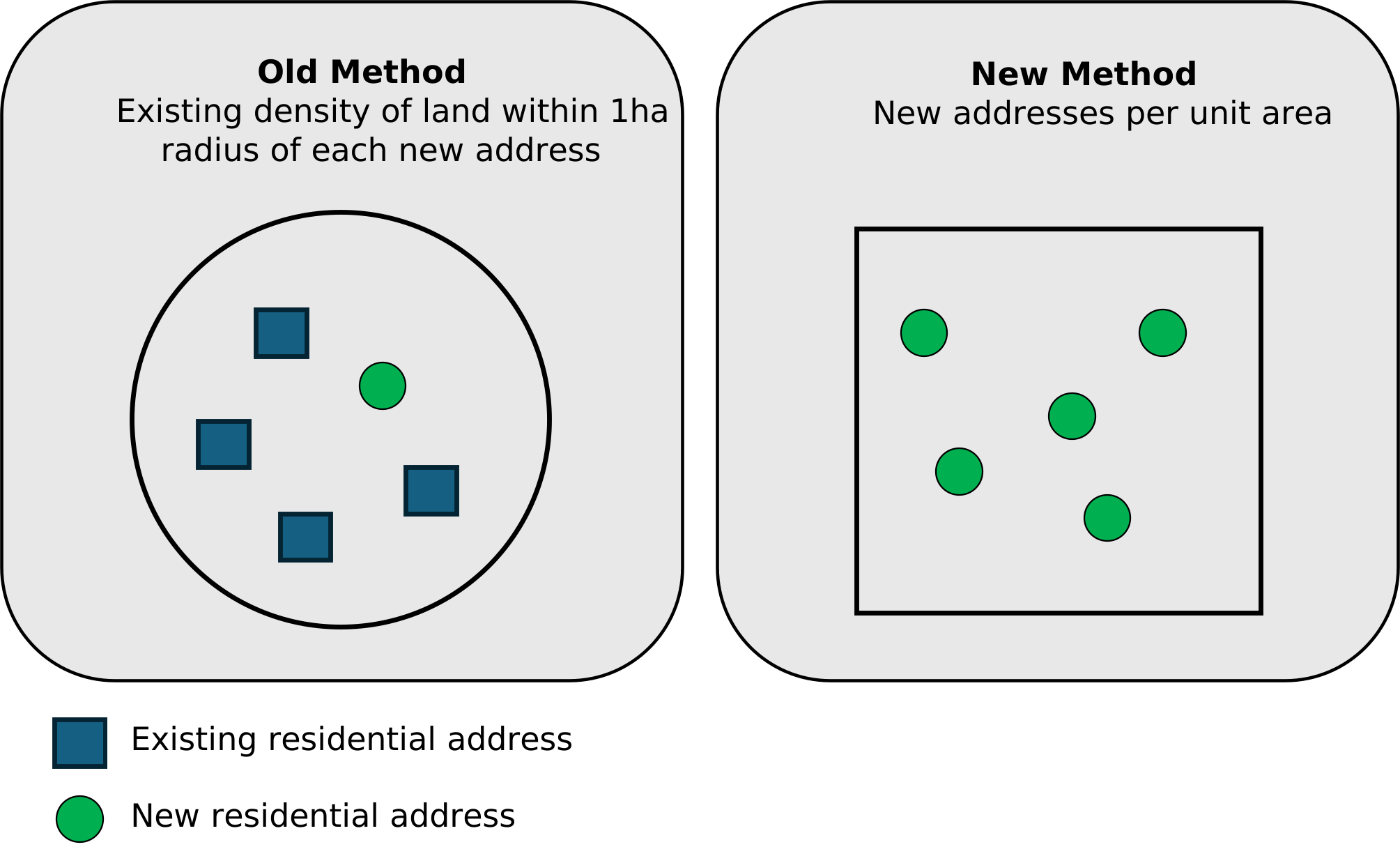
Lastly, we propose to change the ‘density’ metric used in previous new residential addresses releases. In these, we measured the density of new residential development by looking at the area within 1 hectare of each new address. This tells the reader how built-up the land around a new address is, but does not show how many new addresses are appearing in a given area. A single new address on a large, mostly empty plot could show as ‘low density’ even if hundreds of other new addresses are being built nearby. Conversely, a single new address in an already heavily developed area would show as ‘high density’.
For the new series, we propose instead to report the number of new residential addresses per unit area, with the exact spatial resolution reported against still to be determined. This more directly answers the question we think most users want — where new housing is being concentrated — rather than indirectly describing the physical density of the land itself. We consider this measure to better match the common-sense interpretation of ‘density’ in the wider policy context of the land use statistics. An illustration of this can be seen in Figure 2 below.
Figure 2
Figure 2 is a comparison of density calculations for the legacy series (left) and new series (right).
Because each new residential addresses release needs the previous year’s land use stock data as its baseline, the first edition on the new basis will cover 2024 to 2025. One final edition under the old methodology, covering 2022 to 2023, will be published to complete the legacy series by the end of this year.
4.2 Land use change: hectarage
This release measures how much land has moved between land use classes by examining the differences between land use stock snapshots, calculated every 3 years to broadly align with OS’s surveying cycle. As for the new residential addresses release, this basic approach will not fundamentally change for the new series, other than the underlying data and land use classes.
As the hectarage change release is triennial, it requires at least 3 comparable land use stock releases calculated using the new methodology before it can resume, meaning that the first release available will cover the period from 2025 to 2027.
Question 11
Do you use the land use change releases? If so, which measures within them matter most to you — for example, the proportion of new addresses on previously developed land, address density, or hectarage flows between particular categories?
- yes
- no
If yes, explain why.
Question 12
Are you content with the proposal to drop the discrete ‘vacant’ LUCS category and instead classify vacant land by its last known use?
- yes
- no
If no, explain why.
Question 13
Do you agree with the proposed new methodology for calculating new residential address density?
- yes
- no
If no, explain why.
Question 14
Do you have other suggestions for changes or additions to the new residential addresses or hectarage releases?
- yes
- no
If yes, please explain further.
5. Comparability with the legacy series
The new statistics will represent a break in the time series as represented by the legacy statistics from 2013 to 2022. This is unavoidable given the shift from the old LUCS classes to the new OS Tier A/B taxonomy, and in the underlying data from AddressBase/MasterMap to the NGD. The detail at which land is mapped, the way land use is determined, and the way features are grouped into sites all change because of these shifts. Figures from the new series should therefore not be directly compared with those published up to 2022, and we will be explicit about this in the publications.
We considered attempting to mitigate this break by approximately recreating the old LUCS categories from the new data. However, the cross-mapping required to do this would be the department’s own approximation, as the NGD does not natively support LUCS attribution. Given this, and the fact that not all LUCS categories have an obvious or consistent OS Tier A equivalent, such a cross-mapping risks creating a false sense of continuity and comparability between the old and new series that the underlying data cannot reliably support.
If there is a strong user demand for continuity (albeit imperfect) with the old categories, we would explore the feasibility of publishing an approximate correspondence between the LUCS and OS Tier A for users to apply themselves, with clear caveats and at the user’s own risk.
Question 15
How important is comparability with the statistics published up to 2022 for your use of the series?
- very important
- somewhat important
- not important
Explain more.
Question 16
Would an approximate, caveated correspondence between the LUCS and OS Tier A categories be useful to you?
- yes
- no
If no, explain why.
6. Plan for future publications
The legacy data supports publications to 2022; prior to 2024 the NGD data is not yet at sufficient maturity to support the new methodology; in particular, full cross-referencing to the sites layer was not added until September 2024. Our proposal is therefore to establish the new series based on an October 2024 snapshot date, leaving a gap of 1 year between the old and new series.
Subject to this consultation, we therefore intend to resume the full set of land use releases on the following basis:
Land Use in England (stock)
Annual, restarting with the 2024, 2025 and 2026 editions published simultaneously using the same methodological basis.
Land use change: new residential addresses
Annual, restarting with the 2024 to 2025 and 2025 to 2026 editions (the first years for which new-series land use stock data exists as a baseline).
Land use change: hectarage
Every 3 years, with the first new series edition expected in 2027 covering the 2025 to 2027 period of land use stock snapshots.
6.1. Publication format
We initially propose to keep the familiar publication format for the first series of new releases. Each release will consist of a statistical release on GOV.UK - commentary, headline figures, charts and maps - accompanied by downloadable data tables (‘live tables’) and a technical note setting out the methodology in full.
As for the legacy series, the data tables will provide breakdowns below national level: by local authority, and at neighbourhood level (MSOA and LSOA, land use stock release only), along with the established intersections with the Green Belt and areas of flood risk. This starting point aims to replicate the same format and level of geographic detail as the legacy series, so existing users’ workflows carry over with as little disruption as the change of categories allows.
In light of ongoing local government reorganisation, future releases may include additional or alternative spatial breakdowns to ensure no granularity is lost due to, for example, the merging of multiple district councils into a single unitary authority.
The rich and ever-maturing NGD source data gives scope to extend the land use statistics over time — by, for example, adding additional classes of particular interest, or new geographic intersections such as land use within Sites of Special Scientific Interest or National Landscapes. We would welcome views on user priorities in this regard.
6.2. Indicative timelines
The timelines below represent target publication dates and may be subject to change.
| Product | Target publication date |
|---|---|
| Land Use Stock: 2024, 2025 and 2026 | By end of 2026 |
| Subsequent Land Use Stock releases | Annual, in October each year |
| LUC: new residential addresses 2024-25 and 2025-26 | By end of 2026 |
| Subsequent LUC: New Residential Addresses releases | Annual, in October each year |
| LUC: hectarage 2025-2027 | By end of 2027 |
| Subsequent LUC: hectarage releases | Triennial, in October every 3 years |
Question 17
Do you agree with the proposed publication schedule?
- yes
- no
If no, explain why.
Question 18
Do the proposed publication format and geographic breakdowns -local authority, MSOA, LSOA, Green Belt and flood risk - meet your needs?
- yes
- no
If no, explain why.
Question 19
What additional breakdowns, classes or geographic intersections would you find most valuable in future editions?
Question 20
Do you have any other comments or suggestions based on the proposals in this document?
$CTA
Annex A: Legacy LUCS categories
The below categories formed the basis of the land use statistics up to 2022. They no longer exist natively in the NGD data and are included here for context only. Full definitions of each category can be found in the land use change statistics guidance document.
| Group | Category | Code | Type |
|---|---|---|---|
| Community services | Community buildings | C | Developed |
| Community services | Leisure (indoor) | L | Developed |
| Defence buildings | Defence buildings | D | Developed |
| Industry and commerce | Industry | I | Developed |
| Industry and commerce | Offices | J | Developed |
| Industry and commerce | Retail | K | Developed |
| Industry and commerce | Storage and warehousing | S | Developed |
| Minerals and landfill | Minerals and mining | M | Developed |
| Minerals and landfill | Landfill and waste disposal | Y | Developed |
| Other developed use | Unidentified building | ~B | Developed |
| Other developed use | Unidentified general manmade surface | ~M | Developed |
| Other developed use | Unidentified structure | ~S | Developed |
| Other developed use | Unknown surface type with no classification | ~U | Developed |
| Residential | Communal accommodation | Q | Developed |
| Residential | Residential | R | Developed |
| Transport and utilities | Highways and roads | H | Developed |
| Transport and utilities | Transport (other) | T | Developed |
| Transport and utilities | Utilities | U | Developed |
| Agriculture | Agricultural land | A | Non-developed |
| Agriculture | Agricultural buildings | B | Non-developed |
| Forestry, open land and water | Forestry and woodland | F | Non-developed |
| Forestry, open land and water | Rough grassland | G | Non-developed |
| Forestry, open land and water | Natural land | N | Non-developed |
| Forestry, open land and water | Water | W | Non-developed |
| Outdoor recreation | Outdoor recreation | O | Non-developed |
| Residential gardens | Residential gardens | RG | Non-developed |
| Undeveloped land | Undeveloped land | X | Non-developed |
| Vacant land | Vacant land | V | Vacant |
Annex B: proposed new categories
The table below sets out the categories proposed for the new land use stock and land use change publications, built from the OS NGD data using the methodology described in the main body of the consultation. We intend to refine the below categories further prior to publication based on stakeholder feedback, including adding new categories where appropriate and feasible.
Categories are derived from OS Land Use Tier A and Tier B attribution native to the data, supplemented by OS Land Cover Tier A and B where a Land Use Tier A value describes a designation or a physical condition rather than an activity. Provisional developed/non-developed status is not native to the NGD data; as described in section 3.3 it has been assigned on a per-category basis using the NPPF definition of ‘previously developed land’.
OS captures and maintains land use values for every topographic feature through a mix of remote sensing, field survey and desk-based analysis, alongside authoritative third-party data. Further information can be found on the OS docs site.
| Group | Category | Provisional status | What it covers |
|---|---|---|---|
| Agriculture and Aquaculture | Agriculture and Aquaculture | Non-developed | Locations where the cultivation of crops or the rearing of animals, including fish or shellfish, takes place for commercial purposes, including supporting infrastructure |
| Attractions and activities | Historic Features | Developed | Ruins, monuments and other historic features with manmade surfaces, excluding historic houses and memorials |
| Attractions and activities | Sports Facilities | Developed | Locations for viewing or participating in sporting activities |
| Attractions and activities | Other Attractions | Developed | Visitor attractions and leisure activities other than open amenity land |
| Attractions and activities | Outdoor Amenities | Non-developed | Parks, greens, and other open amenity space |
| Commercial activity | Animal Services | Developed | Locations that provide medical care, temporary accommodation, or burial and cremation services for animals |
| Commercial activity | Distribution and Storage | Developed | Locations where goods or materials are stored and / or sorted before being further used. Includes non-retail parts of the distribution chain |
| Commercial activity | Industrial and Manufacturing | Developed | Locations where raw materials are extracted or processed, or where component parts are made into finished items |
| Commercial activity | Retail | Developed | Locations that sell or serve finished goods, including food and drink, to the general public |
| Commercial activity | Other commercial activity | Developed | Locations where commercial activities take place, where a more detailed classification has not been determined or are not otherwise categorised |
| Community and public services | Emergency Services | Developed | Locations used by the providers of emergency services, including supporting sites for administration and training |
| Community and public services | Government Services | Developed | Locations that provide and administer services on behalf of central or local government |
| Community and public services | Medical and Health Care | Developed | Locations that provide primary or secondary medical care and associated health care services |
| Community and public services | Other community services | Developed | Locations that provide primarily non-commercial services to the inhabitants of an area, where the location is not otherwise categorised, such as community centres |
| Community and public services | Religious Worship and Funerary | Developed | Places of worship where members of a religious group gather to practice their faith; locations associated with the burial or cremation of the deceased, including areas used as a memorial for people or events |
| Defence | Defence Infrastructure | Developed | Locations that support the activities of military forces |
| Education | Education | Developed | Educational establishments and locations that provide taught academic and vocational teaching |
| Mixed use and unknown | Mixed Use | Developed | Sites with several uses that cannot be separated |
| Mixed use and unknown | Construction | Developed | Locations where building work is under way and the end use is not yet known |
| Mixed use and unknown | Unknown Artificial: Buildings and Structures | Developed | Man-made buildings and structures with no identified use |
| Mixed use and unknown | Unknown Artificial: Other Manmade Surfaces | Developed | Man-made surfaces with no identified use |
| Mixed use and unknown | Unknown Natural | Non-developed | Natural features with no identified use |
| Mixed use and unknown | Unknown Use | Unknown | Land for which no type or function can be determined |
| Natural and forestry | Mineral | Non-developed | Natural land cover that is mineral in nature, such as Rock, Boulders, Mud, Sand, or Shingle. |
| Natural and forestry | Bare earth or grass | Non-developed | Land that can be interpreted as having a natural surface cover and which is not classified as vegetation. |
| Natural and forestry | Mixed vegetation | Non-developed | An area of open vegetation including heath, marsh, peat, rough grassland, saltmarsh, scrub, and areas of scattered trees |
| Natural and forestry | Broad-leaved woodland | Non-developed | Woodland of non-coniferous trees |
| Natural and forestry | Mixed woodland | Non-developed | Woodland of both coniferous and non-coniferous trees |
| Natural and forestry | Coniferous woodland | Non-developed | Woodland of coniferous trees |
| Natural and forestry | Water | Non-developed | Rivers, lakes, reservoirs, tidal and inter-tidal water |
| Residential | Residential Accommodation | Developed | Locations providing permanent private or communal accommodation, excluding any attached gardens. |
| Residential | Temporary and Holiday Accommodation | Developed | Locations that provide temporary occupation or sites that provide shelter, such as caravan and camp sites, holiday parks and holiday accommodation with hard-standing present |
| Residential | Residential Gardens | Non-developed | Private gardens attached to residential accommodation |
| Transport and utilities | Air, Rail and Water | Developed | Locations that perform and support the movement of people and freight using railways, aircraft and inland or tidal waterways. |
| Transport and utilities | Roads, Tracks and Paths | Developed | Locations that perform and support the movement of people and freight using roads, tracks and paths. Includes movement via motorised (for example, cars, buses) and non-motorised vehicles (for example, bicycles), on horseback and on foot |
| Transport and utilities | Utilities and Environmental Protection | Developed | Locations that facilitate the provision of basic services (such as electricity, gas, water, waste disposal, and telecommunications) and locations used to monitor and control environmental risks, such as flood defences |
| Transport and utilities | Solar Panels | Non-developed | Ground-mounted solar arrays, where provision for restoration has been made |
About this consultation
This consultation document and consultation process have been planned to adhere to the Consultation Principles issued by the Cabinet Office.
Representative groups are asked to give a summary of the people and organisations they represent, and where relevant who else they have consulted in reaching their conclusions when they respond.
Information provided in response to this consultation may be published or disclosed in accordance with the access to information regimes. These are primarily the Freedom of Information Act 2000 (FOIA), the Environmental Information Regulations 2004 and UK data protection legislation. In certain circumstances this may therefore include personal data when required by law.
If you want the information that you provide to be treated as confidential, please be aware that, as a public authority, the department is bound by the information access regimes and may therefore be obliged to disclose all or some of the information you provide. In view of this it would be helpful if you could explain to us why you regard the information you have provided as confidential. If we receive a request for disclosure of the information we will take full account of your explanation, but we cannot give an assurance that confidentiality can be maintained in all circumstances. An automatic confidentiality disclaimer generated by your IT system will not, of itself, be regarded as binding on the department.
The Ministry of Housing, Communities and Local Government will at all times process your personal data in accordance with UK data protection legislation and in the majority of circumstances this will mean that your personal data will not be disclosed to third parties. A full privacy notice is included below.
Individual responses will not be acknowledged unless specifically requested.
Your opinions are valuable to us. Thank you for taking the time to read this document and respond.
Are you satisfied that this consultation has followed the Consultation Principles? If not or you have any other observations about how we can improve the process please contact us via the complaints procedure.
Personal data
The following is to explain your rights and give you the information you are entitled to under UK data protection legislation.
Note that this section only refers to personal data (your name, contact details and any other information that relates to you or another identified or identifiable individual personally) not the content otherwise of your response to the consultation.
1. The identity of the data controller and contact details of our Data Protection Officer
MHCLG is the data controller. The Data Protection Officer can be contacted at dataprotection@communities.gov.uk or by writing to the following address:
Data Protection Officer,
Ministry of Housing, Communities and Local Government,
Fry Building,
2 Marsham Street,
London,
SW1P 4DF
2. Why we are collecting your personal data
Your personal data is being collected as an essential part of the consultation process, so that we can contact you regarding your response and for statistical purposes. We may also use it to contact you about related matters.
We will collect your IP address if you complete a consultation online. We may use this to ensure that each person only completes a survey once. We will not use this data for any other purpose.
Sensitive types of personal data
Please do not share special category personal data or criminal offence data if we have not asked for this unless absolutely necessary for the purposes of your consultation response. By ‘special category personal data’, we mean information about a living individual’s:
- race
- ethnic origin
- political opinions
- religious or philosophical beliefs
- trade union membership
- genetics
- biometrics
- health (including disability-related information)
- sex life
- sexual orientation
By ‘criminal offence data’, we mean information relating to a living individual’s criminal convictions or offences or related security measures.
3. Our legal basis for processing your personal data
The collection of your personal data is lawful under article 6(1)(e) of the UK General Data Protection Regulation as it is necessary for the performance by MHCLG of a task in the public interest/in the exercise of official authority vested in the data controller. Section 8(d) of the Data Protection Act 2018 states that this will include processing of personal data that is necessary for the exercise of a function of the Crown, a Minister of the Crown or a government department i.e. in this case a consultation.
Where necessary for the purposes of this consultation, our lawful basis for the processing of any special category personal data or ‘criminal offence’ data (terms explained under ‘Sensitive Types of Data’) which you submit in response to this consultation is as follows. The relevant lawful basis for the processing of special category personal data is Article 9(2)(g) UK GDPR (‘substantial public interest’), and Schedule 1 paragraph 6 of the Data Protection Act 2018 (‘statutory etc and government purposes’). The relevant lawful basis in relation to personal data relating to criminal convictions and offences data is likewise provided by Schedule 1 paragraph 6 of the Data Protection Act 2018.
4. With whom we will be sharing your personal data
MHCLG may appoint a ‘data processor’, acting on behalf of the department and under our instruction, to help analyse the responses to this consultation. Where we do we will ensure that the processing of your personal data remains in strict accordance with the requirements of the data protection legislation.
We may use artificial intelligence (AI) tools to analyse the responses to consultations more efficiently. These tools assist in identifying and mapping themes in consultation responses, but do not make decisions and all outputs are reviewed by staff for accuracy and reliability. Data used in AI tools is not used for training the AI models.
5. For how long we will keep your personal data, or criteria used to determine the retention period
Your personal data will be held for 2 years from the closure of the consultation, unless we identify that its continued retention is unnecessary before that point.
6. Your rights, e.g. access, rectification, restriction, objection
The data we are collecting is your personal data, and you have considerable say over what happens to it. You have the right:
a. to see what data we have about you
b. to ask us to stop using your data, but keep it on record
c. to ask to have your data corrected if it is incorrect or incomplete
d. to object to our use of your personal data in certain circumstances
e. to lodge a complaint with the independent Information Commissioner (ICO) if you think we are not handling your data fairly or in accordance with the law. You can contact the ICO at https://ico.org.uk/, or telephone 0303 123 1113.
Please contact us at the following address if you wish to exercise the rights listed above, except the right to lodge a complaint with the ICO. Email dataprotection@communities.gov.uk or write to:
Knowledge and Information Access Team,
Ministry of Housing, Communities and Local Government,
Fry Building,
2 Marsham Street,
London,
SW1P 4DF
7.Your personal data will not be sent overseas.
8. Your personal data will not be used for any automated decision making.
9. Your personal data will be stored in a secure government IT system
We use a third-party system, Citizen Space, to collect consultation responses. In the first instance your personal data will be stored on their secure UK-based server. Your personal data will be transferred to our secure government IT system as soon as possible, and it will be stored there for 2 years before it is deleted.