Annex 1: Supporting map(s)
You must create and submit a map to support your application.
You can create your base map by printing your land parcel digital maps in the Rural Payments service. On the ‘Business overview’ screen click ‘View land’ then click the relevant land parcel. The option to print is below the map. Make sure your printed map is clear, readable and meets the standards set out below.
If you cannot print the map you can call us or you can use MAGIC maps on GOV.UK – search for ‘www.magic.defra.gov.uk’. If you choose magic.gov.uk, use the ‘export map tool’ as this adds the required licence information. Wherever you get your base map from, make sure it has the copyright licence for this use.
The map must meet the following requirements:
-
A3 or A4 in size (either is acceptable).
-
1:2,500 or 1:10,000 scale, unless using the Rural Payments Land View screen in the Rural Payments service to produce a map as it will automatically scale the map to fit A4 which is acceptable.
-
It must show the whole land parcel on which the boundaries to be included are located and the boundaries of the land parcel must be clear.
Mark your map(s) to show the location of your CS capital items on your land parcels. It may help to complete the application and your map(s) alongside each other.
If your application is successful and you are offered an agreement, your CS capital map(s) will become your ‘Agreement Map(s)’.
The map must include the following.
-
Map number. Include a unique map number and total number of maps for example, 1 of 3.
-
Scale of the map.
-
Single Business Identifier (SBI) – consisting of 9 digits; application year; and agreement title (as entered in the application), write these on the top right of the map.
-
Name of business – this should be the name that is registered with us for the SBI, write this on the right hand side of the map.
-
If there are no numbered Ordnance Survey (OS) grid lines, you must write a 6 figure OS grid reference for the centre of the map on the bottom left of the map (format AB 123 456).
-
Land parcel reference number, for example, SK 1234 5678, for the land parcels where the capital items will be undertaken.
-
Circle the land parcel reference number for all parcels that you include in your application.
-
Add the capital item code to the land parcel where the capital works will be undertaken.
-
Mark the boundaries you include in your application with a thick black line. You only need to include the land parcel(s) adjacent to one side of each boundary, you do not need to include the land parcels on both sides of a boundary.
-
Use black ink for all annotations on your map. If you make a mistake do not use correcting fluid, strike through the mistake instead.
If you send a map that does not meet these requirements, we’ll return it to you to amend or ask you to send us a new one. You’ll need to complete this map to the minimum standard and return it to us.
These items require extra information, this must be provided on a supplementary map:
| Option | Name of option | Evidence required at application stage |
|---|---|---|
| BN3 | Earth Bank Creation | historic maps or other records to evidence that the proposed location of the bank creation is on an original footprint, or is a feature of a specific location or landscape – this can be marked on any map |
| BN5 | Hedgerow laying | a map showing the location of existing hedgerow trees in each length of hedge |
| BN6 | Hedgerow coppicing | a map showing the location of existing hedgerow trees in each length of hedge |
| BN11 | Planting new hedges | historic map or other records to show that the proposed location of the hedge planting is on an original footprint or extends existing hedges or contributes to the reduction of soil erosion and run-off – this can be marked on any map |
| BN12 | Stone wall restoration | a map showing the location of any wall-side trees, saplings and stone features |
| TE1 | Planting standard hedgerow tree | a record of where hedgerow trees are to be planted |
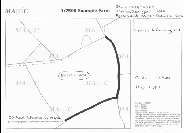
The example map shows what you need to note on your map. In this example, the land parcel number is hand-written in the middle of the land parcel. A thick line is drawn along 2 sides of the land parcel to show a new or changed boundary. The map scale and OS grid references are hand-written on the map as well as the SBI, application year and the agreement name.